Browse Listings in Some results in last auction
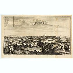
La ville de Moscou, capitale de la Moscovie.
Decorative panoramic view of Moscow. Below the engraving a numbered key (1- 24) of the important buildings of the city. This well executed engraving was published in 1729...
Place & Date: Leiden, 1719
Selling price: $650
Sold in 2021
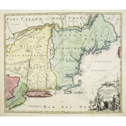
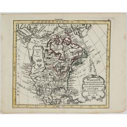
Nova Anglia Septentrionali Americae implantata . . .
German interest in North America was high during the first half of the eighteenth century when Johann Baptiste Homann was the leading German cartographer. During this per...
Place & Date: Nurnberg, 1720
Selling price: $1050
Sold in 2022
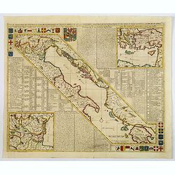
Carte de Géographie des différents Etats de la République de Venise . . .
An interesting map of the Gulf of Venice with inset map of the surroundings of Venice and map of Turkey in upper right corner. Plenty of descriptive French text, from Cha...
Place & Date: Amsterdam, 1720
Selling price: $225
Sold in 2021
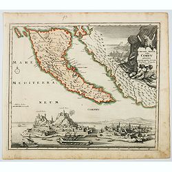
Corcyrae Insula, vulgo Corfu planities unacum parte Greciae.
A scarce map of Greece’s most northerly island, originally drawn by Christoph Weigel, well known as one of the 18th century’s most prolific map makers. To the right o...
Place & Date: Nurnberg, ca 1720
Selling price: $150
Sold in 2021
-250x250.jpg)
Orbis Terrarum
Dutch so-called ' Staten' bibles, published between 1637 and c. 1760, contained 5 maps: The World, ' Paradise', The Perigrinations, The Promised Land Canaan, The Travels ...
Place & Date: Amsterdam, c. 1720
Selling price: $1500
Sold in 2022
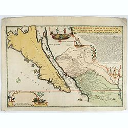
La Californie ou Nouvelle Caroline.
This fine rare map is a reissue of de Fer's map of 1705 but on a larger scale, and with some notable additions. A boldly engraved and handsome item, the largest scale map...
Place & Date: Paris, 1720
Selling price: $5600
Sold in 2022
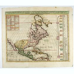
Nouvelle Carte de l' Amerique Septentrionale Dressee sur les plus Nouvelles Observations de Messieurs de l' Academie. . .
Great map of North America with well developed cartography in the Great Lakes and Mississippi River.It includes all of Central America and the West Indies. The English se...
Place & Date: Amsterdam, 1720
Selling price: $275
Sold in 2022
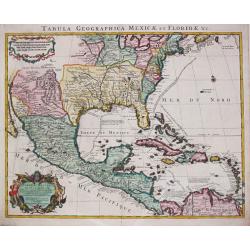
Tabula Geographica Mexicae et Floride des Terres Angloises et des Isles Antilles, du Cours et des Environs de la Riviere de Mississipi. Par G. de l' Isle a Amsterdam chéz Jean Covens & Corneille Mortier. 1722.
Guillaume de l' Isle (1675-1724), Royal Geographer, was the most influential cartographer of the first quarter of the 18th century. ' Atlas de Géographie' (1700-12), pos...
Place & Date: Amsterdam, 1722
Selling price: $750
Sold in 2022
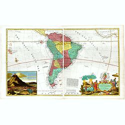
...this map of South America...
Map of South America including part of Central America. Cartographic elements include lines of latitude and longitude, compass rose, indication of wind directions, locati...
Place & Date: London 1725
Selling price: $2100
Sold in 2021
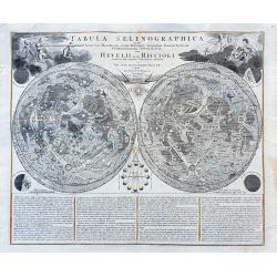
Tabula Selenographica in qua Lunarium. . .
A fantastic and important chart of the Moon after Johann Gabriel Doppelmayr, from the "Atlas Coelestis in quo Mundus Spectabilis". It shows a comparison of the ...
Place & Date: Nuremberg, ca 1742
Selling price: $800
Sold in 2021
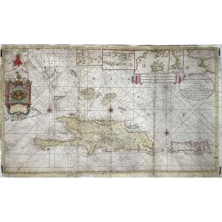
Nieuwe en Naaukeurige Paskaart van Het Eyland Hispaniola of St. Domingo met alle desselfs Havenen, Dieptens en Ankergronden, als meede de door passeeringe tusche de Caiques en andere Eylanden. ..
Fine Sea Chart of Puerto Rico and Hispaniola, published by Johannes Van Keulen II. A rare map since these larger sized sheets were never published in atlases but were ra...
Place & Date: 1742
Selling price: $2450
Sold in 2022

Nicolas De Fer Geographe de Sa Majesté Catholique et de Monseigneur Le Dauphin. Mort en 17120, agé de 74 ans.
An oval portrait of Nicolas De Fer, engraved by Pierre Dupin d'après Hyacinthe Rigaud. Dated 1746. Presented at the waist, the bust turned three-quarters towards the rig...
Place & Date: Paris, 1746
Selling price: $500
Sold in 2022
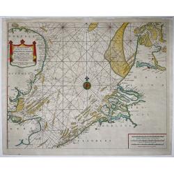
A Correct Chart of the Sea Coasts of England, Flanders, and Holland…
Nice example of Mount & Page's map of the Channel showing the coastlines of England, Belgium and Holland.Published at first in 1671-1672 in John Seller's 'The English...
Place & Date: London, ca. 1750
Selling price: $525
Sold in 2021
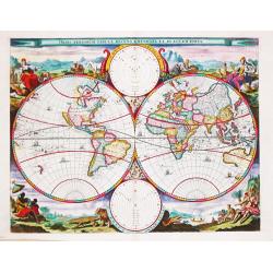
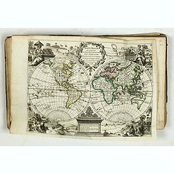
Orbis Terrarum Tabula Recens Emendata Et In Lucem Edita.
A world map in two hemispheres, decorated in the corners with the representations of the four continents in allegorical form.
Place & Date: Amsterdam, c. 1750
Selling price: $1160
Sold in 2022
Atlas nouveau portatif à l'usage des militaires et du voyageur.
>Charming atlas with an engraved title, and 91 numbered and engraved double-page maps in orginal out line colors. The atlas starts by 36 pages text entitled 'Introduct...
Place & Date: Paris, Le Rouge, Prault, Veuve Robinot, Briasson, 1756
Selling price: $2300
Sold in 2022
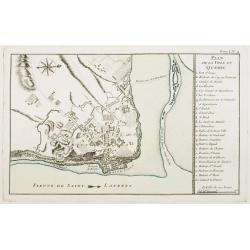
Plan de la Ville de Québec.
A detailed plan the territories of city of Québec. With a lettered key, indicating the principal places in town.The only issue of this version of Bellin's map, slightly ...
Place & Date: Paris, 1764
Selling price: $300
Sold in 2021
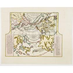
Carte des Nouvelles découvertes. . .
This map is most notable for it's depiction of "Mer de L'Ouest" or "Sea of the West", a great sea, easily the size of the Mediterranean, to flow from ...
Place & Date: Paris, 1770
Selling price: $200
Sold in 2022
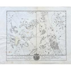
To Count Cyrillus de Rasumowsky...
Very rare copper-engraved celestial chart on hand-laid paper! We could not trace any other example or reference to it. Shows many prominent star constellations. Below wit...
Place & Date: ca. 1770
Selling price: $200
Sold in 2022
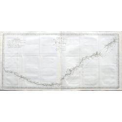
Carte de la Nle. Galles Merid.le ou de la Cote Orientale de la Nle. Hollande Découverte et visiteé par le Lieutenant J. Cook, Commandant de l'Endeavor. . .
One of Cook's most famous charts, the important first map of New South Wales, Australia. Oriented with north to the right side, and it extends from Point Hicks and Cape H...
Place & Date: Paris, ca 1774
Selling price: $350
Sold in 2021
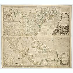
An Accurate Map of North America. Describing and Distinguishing the British and Spanish Dominions on this Great Continent. According to the Definitive Treaty Concluded at Paris 10th Feb. 1763.
The outstanding British map of North America created on the eve of the American Revolution, this is the desirable fourth Robert Sayer (1725-1794) issued 1775 edition of B...
Place & Date: London, Robert Sayer, 1775
Selling price: $1900
Sold in 2022
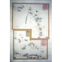
LESSER ANTILLES,- Carte réduite des îles Antilles au nord du 13me. degré de latitude.. / TURKS-CAICOS-BAHAMAS,- Carte réduite des debouquements de St. Domingue..
Two engraved maps together on one large sheet, the first covering the Leeward Islands from Puerto Rico to Barbados, the second showing the Turks and Caicos Islands and so...
Place & Date: Paris, 1775
Selling price: $600
Sold in 2022
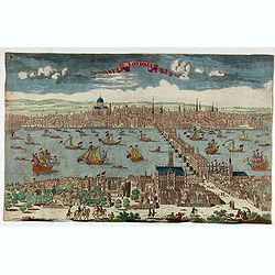
Londres.
Decorative print of London.
Place & Date: Paris, ca. 1780
Selling price: $450
Sold in 2022
Amerique Septentrionale avec les Nouvelles Découvertes
The map of the North America in a quiet unusual shape.Comes from rarely seen Jean-Baptiste Nolin atlas “Atlas Général a l’usage des colleges et maisons d’educatio...
Place & Date: Paris, 1783
Selling price: $300
Sold in 2022
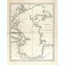
Carte de la Mer Caspienne 1785.
Large and detailed chart, with numerous soundings, as mapped by Jean Antoine Guldenstaedt (1745-1781), a Russian naturalist, who surveyed the area in 1771-1773. Engraved ...
Place & Date: Paris, Dezauche, ca 1785
Selling price: $170
Sold in 2021
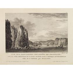
Vue Des Montagnes Escarpées De Fraisler, Sur La Côte Orientale De La Baye George Dans L'Amérique Septentrionale. Atlas de ce Continent, par Desbares.
Fine view of St. Georges Bay, Nova Scotia, east coast of Canada. '12.' inscribed upper right. Engraved by Pillement. "A Paris, chez Noel, Md. D'Estampes, Rue St. Jac...
Place & Date: Paris, ca. 1790
Selling price: $60
Sold in 2021
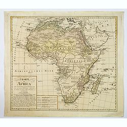
Charte von Africa.
An uncommon late eighteenth-century map of the continent of Africa, prepared by Güssefeld, based on earlier work done by Sayer and Rennel. Gussefeld worked for the Homan...
Place & Date: Nuremberg, 1797
Selling price: $91
Sold in 2021
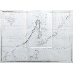
Carte des Découvertes Faites en 1787 dans les Mers de Chine et de Tartarie par les Frégates Françaises la Boußole et l'Astrolabe depuis leur Départ de Manille. . .
A nice large chart of the Asian coast, with parts of Korea, the Russian coast, the Sea of Okhotsk, the Sea of Japan, Hokkaido with unfinished coastline, Sakhalin, and of ...
Place & Date: Paris, 1797
Selling price: $200
Sold in 2022
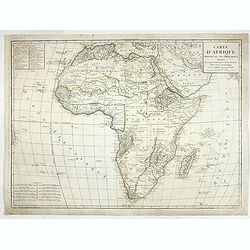
Carte d'Afrique
Fine detailed map of Africa. Prepared by J.B.Poirson and Herison. Upper left hand corner 2 blocks listing the foreign English, Dutch, Spanish, Portuguese and Danish posse...
Place & Date: Paris, 1798
Selling price: $110
Sold in 2022
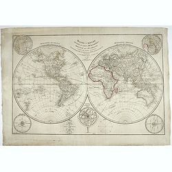
Mappe-monde divisée en deux hémisphères, oriental et occidental, assujetties aux dernières découvertes de Mrs de Bougainville, Surville, Cartret. Wallis, Furneau, Cook, etc, Par J.-B. Poirson...
Fine detailed world map in double hemispheres. Prepared by J.B.Poirson and Herison. According to the title the map is updated with info from travels by de Bougainvill...
Place & Date: Paris, 1798
Selling price: $200
Sold in 2022

Rose à cent feuilles - Rosa contifolia L.
A bouquet of Roses. Engraved by P.F. Le Grand after designs by the Dutch-born Gerard van Spaendonck (1746-1822).Taken from the rare work "Fleurs dessinées d'après ...
Place & Date: Paris, c.1800
Selling price: $220
Sold in 2022
![[Lot of 2 manuscript maps] Schetskaart van het westelijk vaarwater naar de reede van Ternate. [together with ] Sketch of the island of Ternate, Tidore and to the Southward.](/uploads/cache/47989-250x250.jpg)
[Lot of 2 manuscript maps] Schetskaart van het westelijk vaarwater naar de reede van Ternate. [together with ] Sketch of the island of Ternate, Tidore and to the Southward.
Two rare manuscript maps being one general map of the spice islands and a detailed map of the South Western Channel in front of the town Ternate with the island "Noo...
Place & Date: Ternate ?, ca. 1800-1810
Selling price: $850
Sold in 2022
![[Official US Government Document.]](/uploads/cache/48156-250x250.jpg)
[Official US Government Document.]
An official US government printed document, completed in manuscript. An attractive copper engraved broadside, signed by President James Madison, appointing Daniel Chandle...
Place & Date: Washington D.C., 1812
Selling price: $1550
Sold in 2022
![[Official US Government Document.]](/uploads/cache/48153-250x250.jpg)
[Official US Government Document.]
Washington, D.C. February, 1815. partially-printed document, completed in manuscript, with a paper seal of the United States affixed to lower left corner. An official pre...
Place & Date: Washington D.C., 1815
Selling price: $1400
Sold in 2022
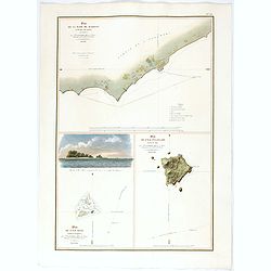
Plan De La Rade De Raheina sur l'Ile Mowi (Iles Sandwich).
Exceedingly rare plan of Lahaina and its anchorages, the earliest obtainable map of Maui based upon actual surveys.This coastal charting of Lahaina, Maui, "Plan de l...
Place & Date: Paris, 1819
Selling price: $1400
Sold in 2022
![Nouvelle-Hollande: Ile King. L'Elephant-Marin ou Phoque a Trompe. [plate XXXII]](/uploads/cache/40118-250x250.jpg)
Nouvelle-Hollande: Ile King. L'Elephant-Marin ou Phoque a Trompe. [plate XXXII]
Sea Lions lying on a beach on King Island off the South Australian coast, after the original sketches by Lesueur, from Voyage de découvertes aux terres Australes by Fran...
Place & Date: Paris, 1824
Selling price: $75
Sold in 2021
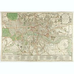
Bowles's one-sheet pan of the cities of London and Westminster
Bowles detailed map of London was updated regularly through the first decade of the 19th century. In addition to providing large scale detail, Bowles maps are also illust...
Place & Date: London, 1825
Selling price: $500
Sold in 2022
![[The Morai. Hawaiian Islands ].](/uploads/cache/26379-250x250.jpg)
[The Morai. Hawaiian Islands ].
Aquatint depicting the Morai (Tahiti), a burying ground and a place of worship where human sacrifices were performed. Engraved by Castelli. Plate N° 84. From Giulio Ferr...
Place & Date: Milan, 1827
Selling price: $50
Sold in 2021
![[TEXAS] Set of 5 maps in plano format, on an uniform scale, covering Texas.](/uploads/cache/35573-250x250.jpg)
[TEXAS] Set of 5 maps in plano format, on an uniform scale, covering Texas.
A set of 5 plano sheet maps covering Texas, from Vandermaelen's famous Atlas Universel.It is to be noted that only a handful of these were made in plano format (they were...
Place & Date: Brussels, 1825-1827
Selling price: $1500
Sold in 2021
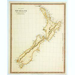
The Islands of New Zealand.
This is a map of New Zealand produced by the Society for the Diffusion of Useful Knowledge (S.D.U.K.). It covers the entire island country from Cape Reinga (C. Maria Van ...
Place & Date: London, 1838
Selling price: $120
Sold in 2021
![[Title page] Voyage pittoresque et archaéologique en Russie.](/uploads/cache/43490-250x250.jpg)
[Title page] Voyage pittoresque et archaéologique en Russie.
Title page of "Voyage pittoresque et archaéologique en Russie" with two joined pages. The first is a letter for a certain "Mathilde" from Anatole Dé...
Place & Date: Paris, 1844
Selling price: $100
Sold in 2021
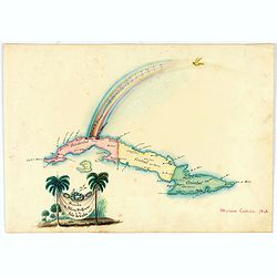
Arribo de Albina Steffanoni a la Isla de CUBA. 1848.
Fine manuscript map of Cuba made on the occasion of the visit of soprano Balbina Steffenone to Cuba in 1848. The map is carefully drawn and heightened by watercolors, orn...
Place & Date: Habana, 1848
Selling price: $500
Sold in 2022
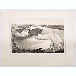
Vue Generale du Niagara a Vol d'Oiseau.
A spectacular view of Niagara Falls, the Horseshoe Falls in the foreground looking upstream towards Lake Erie. It was lithographed by Eugene Ciceri (1813 -90) after the v...
Place & Date: Paris, ca 1851
Selling price: $150
Sold in 2021
![Karta Kievskoi Gubernii [Kiev Governorate, Ukraine].](/uploads/cache/34757-250x250.jpg)
Karta Kievskoi Gubernii [Kiev Governorate, Ukraine].
A detailed map of Ukraine's Kyiv Governorate, printed in St. Petersburg by Alexey Afinogenovich Ilyin, one of the most important 19th Century maps of the region.This fine...
Place & Date: St. Petersburg, 1871
Selling price: $750
Sold in 2021
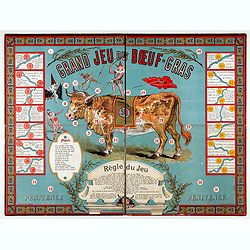
Le bœuf-gras. (Boardgame).
Rare boardgame named "The big game of the fat ox". The celebration of the fat ox was a central custom of the Paris Carnival, which was held at mid-Lent, a perio...
Place & Date: Paris, ca. 1880
Selling price: $600
Sold in 2022
![[Untitled - Le Voyage Autour du Monde en 80 jours: d'apres le Romain de Jules Verne.]](/uploads/cache/48134-250x250.jpg)
[Untitled - Le Voyage Autour du Monde en 80 jours: d'apres le Romain de Jules Verne.]
This lovely children's games of the novel by Jules Verne game is without its illustrated box, six little hand-painted lead playing pieces (modeled on characters in the no...
Place & Date: Paris, ca 1880
Selling price: $350
Sold in 2022
![[Complete map of ancient and modern geography of China]](/uploads/cache/18997-250x250.jpg)
[Complete map of ancient and modern geography of China]
A variant of a so-called "Complete map of ancient and modern geography of China.". The map shows Korea in the east to Central Asia in the west, and from Heilong...
Place & Date: China, ca. 1888
Selling price: $15000
Sold in 2022
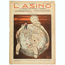
L'Asino e il popolo utile paziente e bastonato.
A satirical look at the Roman Catholic churches' ever-reaching take over of the globe. Pope Pius X is seen sitting beneath the glove, with his arms stretched as far as th...
Place & Date: Rome, 1908
Selling price: $190
Sold in 2021

Vellum leaf with a large miniature showing saint surrounded by noble women in typical medieval dresses.
A large miniature (225x215mm) showing a scene with in the center a saint surrounded by medieval figures (Isabella of France and her son the future Edward III ?) descendin...
Place & Date: Paris (?), c.1890-1920
Selling price: $3000
Sold in 2022
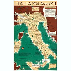
Italia 1934 - Anno XII.
A very satirical map of Italy that heavily criticizes the Fascist regime in the country, with many unflattering notes attached to places and regions. (ie SARDINIA "...
Place & Date: Connecticut, 1934
Selling price: $155
Sold in 2021
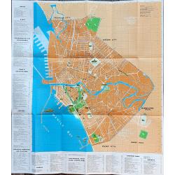
Manila and bay area
An unusual tourist leaflet with a large map of Manila, printed around 1960. Gives information about many locations, hotels, banks, government offices, clubs, churches, em...
Place & Date: Manila, ca. 1960
Selling price: $100
Sold in 2022

Hong Kong.
Decorative poster advertising flights to Hong Kong made by Georges Mathieu. The poster is published outside his series of 15 composed of posters of Greece, Israel, German...
Place & Date: Paris, 1967
Selling price: $850
Sold in 2021
![[Anti capitalism Soviet Union propaganda poster]](/uploads/cache/47024-250x250.jpg)
[Anti capitalism Soviet Union propaganda poster]
Propaganda mini anti-capitalism poster published in Russia during The Cold War. By the 1960’s and 1970’s, outrageous practices in Soviet bureaucracy flourished. Poor ...
Place & Date: Leningrad, 1974
Selling price: $100
Sold in 2022
![[Anti capitalism Soviet Union propaganda poster]](/uploads/cache/47023-250x250.jpg)
[Anti capitalism Soviet Union propaganda poster]
Propaganda mini anti-capitalism poster published in Russia during The Cold War. By the 1960’s and 1970’s, outrageous practices in Soviet bureaucracy flourished. Poor ...
Place & Date: Leningrad, 1979
Selling price: $100
Sold in 2022
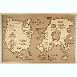
The World According To Ronald Reagan.
Lively political satire map, depicting the World According to Ronald Reagan. In the center of the map are large caricatures of Ronald Reagan, dressed as a cowboy and stan...
Place & Date: Seattle, 1982
Selling price: $750
Sold in 2022

Stop arms race, stop nuclear madness, eliminate nuclear weapons.
Uncommon Soviet propaganda poster against the nuclear race.Read more about the Soviet propaganda poster. [+]
Place & Date: Moscow, 1987
Selling price: $100
Sold in 2022

Harpers Christmas.
Les Affiches Étrangères were printed in 1895-1896 by Jules Cheret of the Chaix Imprimerie. The plates are printed in stone lithography. "Harpers Christmas" st...
Place & Date: 1897 paris
Selling price: $150
Sold in 2021