Browse Listings
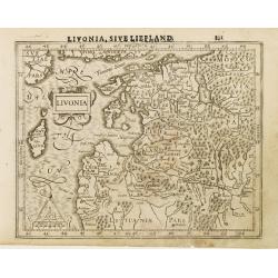
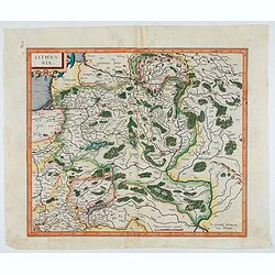
Livonia.
Finely engraved small map of the Baltic states Estonia and Latvia filled with forests, rivers and lakes. Latin text on verso.Embellished with a strap work title cartouche...
Date: Amsterdam, 1610
Selling price: ????
Please login to see price!
Sold in 2008
![Gades oder Cales Males duch die Englischen und Hollender eingenomen [1596]](/uploads/cache/26898-250x250.jpg)
Gades oder Cales Males duch die Englischen und Hollender eingenomen [1596]
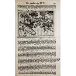
Showing in a bird's-eye view of the siege by the English and Dutch forces of the town Cadiz during June and July 1596. The town of Seville is shown in the upper left corn...
Date: Cologne, 1610
Selling price: ????
Please login to see price!
Sold in 2009
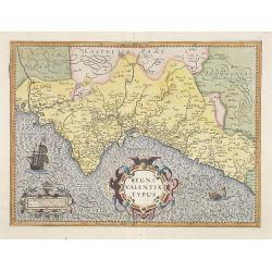
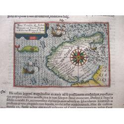
Regni Valentiae Typus.
Fine early map of Valencia and covering the coastline from Cartagena to Benicarlo. North is oriented to the right.The map is decorated with a sailing ship, sea monster, t...
Date: Amsterdam, 1610
Selling price: ????
Please login to see price!
Sold in 2009
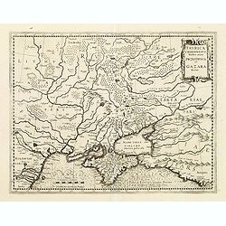
Taurica Chersonesus Nostra aetate Przecopsca et Gazara dicitur.
Mercator's fine map of the region north of the Black Sea encompassing the Crimea and the southern steppes of Ukraine. This map served as the basis of most other cartograp...
Date: Amsterdam, 1610
Selling price: ????
Please login to see price!
Sold in 2010
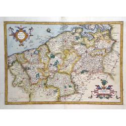
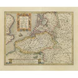
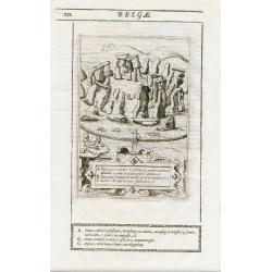
Flandria Comit.
Finely detailed map of of Belgium region from the Mercator/Hondius atlas. Accompanying French text is on verso. Shows cities of Brussels and Antwerp in the west, Namur in...
Date: Amsterdam, 1610
Selling price: ????
Please login to see price!
Sold in 2010
Northumbria, cum Berlandia, et Dunelmensis Episcopatus.
A lovely early map of border region between England and Scotland. The seas are engraved in Mercator's characteristic wave pattern and the interior is filled with detail. ...
Date: Amsterdam, 1610
Selling price: ????
Please login to see price!
Sold in 2010
Le Duche de Brabant (untitled)
Fine Mercator/Hondius map of the Brabant region of Northern Belgium. Shows the city of Brussels in the west. Accompanying French text is on verso. Fantastic, vibrant orig...
Date: Amsterdam, 1610
Selling price: ????
Please login to see price!
Sold in 2010
Belgii inferioris descriptio. . .
One of the earliest maps of the Low Countries. Including now-a-days The Netherlands in the north to Luxembourg in the South, centered on Zeeland and the Rhine River.
Date: Amsterdam, 1610
Selling price: ????
Please login to see price!
Sold in 2011
Merionethshire, Described 1610.
A beautiful Welsh county map of Merionethshire; part of the renowned “Theatre of the Empire of Great Britaine” by English cartographer John Speed. The copper plates w...
Date: London, 1610
Selling price: ????
Please login to see price!
Sold in 2020
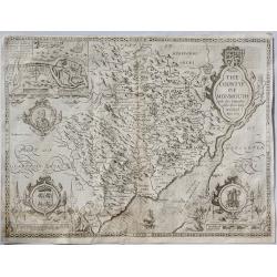
The Countye of Monmouth. . .
A beautiful Welsh county map of Monmouth Shire; part of the renowned “Theatre of the Empire of Great Britaine” by English cartographer John Speed. The copper plates w...
Date: London, ca. 1610
Selling price: ????
Please login to see price!
Sold in 2019
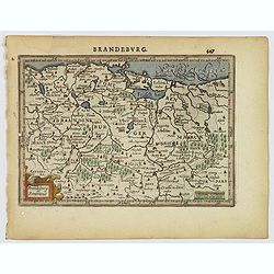
Brandeburg et Pomerania.
A nice small map of Brandenburg and Pomerania, in northeastern Germany, with the western portion of Poland. Berlin is shown roughly in the center of the map. Many larger ...
Date: Amsterdam, 1610
Selling price: ????
Please login to see price!
Sold in 2021
L'Isle de France, Parisiesis Agri Descriptio Auctore.
This is a handsome and detailed map of the region of Paris and its vicinity, attributed to Francois de la Guillotiere. It is beautifully engraved with forests, rivers, ci...
Date: Amsterdam, ca 1610
Selling price: ????
Please login to see price!
Sold in 2021
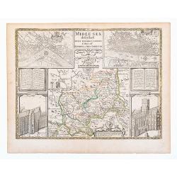
Middlesex. Midle-sex described With The Most Famous Cities Of London and Westminster.
Old outline color to map of the county delineating the hundreds. Double page. A wonderfully decorative map of Middlesex incorporating maps of London and Westminster to up...
Date: London, Thomas Basset and Richard Chiswell. 1610
Selling price: ????
Please login to see price!
Sold in 2020
![[Celestial Gores.]](/uploads/cache/46376-250x250.jpg)
[Celestial Gores.]
A single engraved sheet of 12 small gores making up a 11,5 cm (4,5 inch) celestial globe, sheet size 190 x 365 mm, the diameter of globe is 116 mm. First gore with dedica...
Date: Lyon, 1610
Selling price: ????
Please login to see price!
Sold in 2020
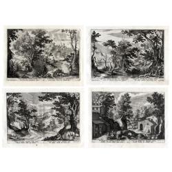
A set of four landscapes with the story of the Good Samaritan.
After designs by Paul Bril (1554-1626). Raphael Sadeler (1584-1632) was a Flemish engraver, part of the very active Sadeler family. Paul Bril (1554-1626) was a landscape ...
Date: ca. 1610
Selling price: ????
Please login to see price!
Sold in 2021
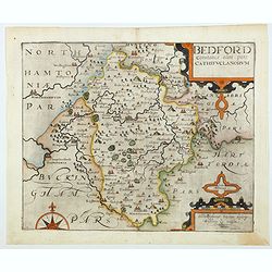
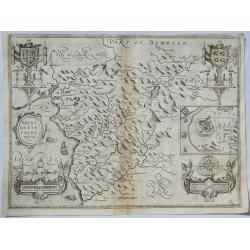
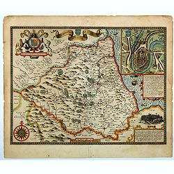
Bedford Comitatus olim pars Cathifuclanorum.
A beautiful early 17th century map of Befordshire, based on the first survey of England by Christopher Saxton, and published in Camden's Britannia (pub. London: 1607-1637...
Date: London, 1610
Selling price: ????
Please login to see price!
Sold in 2021
Lithuania.
One of the earliest maps of Lithuania and Poland.
Date: Amsterdam, ca. 1610
Selling price: ????
Please login to see price!
Sold in 2023
![[Lot of 6 maps of the Provence, Marseille, Cannes, Nice, France.] Provenciae, Regionis Galliae, vera exactissimiaqs descriptio. Petro Ionne Bompario auctore. / Provence / Baptista Doetecomius Sculp.](/uploads/cache/18218-(1)-250x250.jpg)
[Lot of 6 maps of the Provence, Marseille, Cannes, Nice, France.] Provenciae, Regionis Galliae, vera exactissimiaqs descriptio. Petro Ionne Bompario auctore. / Provence / Baptista Doetecomius Sculp.
An early and most decorative map of the Provence with the Riviera from the Rhone estuary, Marseille, Cannes, Nice to Vintimiglia. Engraved by Baptista Van Doetechum for...
Date: Amsterdam, c. 1610
Selling price: ????
Please login to see price!
Sold in 2023
![[Berkshire]. Bercheriae vulgo Barkshyre qui olim sedes A:Trebatum.](/uploads/cache/1156346-250x250.jpg)
[Berkshire]. Bercheriae vulgo Barkshyre qui olim sedes A:Trebatum.
Original uncoloured engraved map of Berkshire trimmed to neatline and backed onto 18th century laid paper. Map dimensions 23 x 32 cm, overall backing-sheet size 32 x 40 c...
Date: London: Impensis Georgii Bishop & Ioannis Norton, 1610
Selling price: ????
Please login to see price!
Sold in 2023
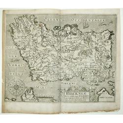
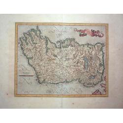
Hiberniae Ireland Anglis Yuerdon Britannis Erin incolis Ierna Orpheo & Arist. Iris Diodoro Siculo Juverna Juvenali Joyernia Ptol.Christopher Saxton & William Hole
One of the earliest obtainable maps of Ireland. Oriented with West at the top. Highly detailed.This map of Ireland is derived from Baptista Boazio's map of Ireland dating...
Date: London, 1610
Selling price: ????
Please login to see price!
Sold in 2013
Stonehenge.
Stonehenge from 1610 edition of Camden’s Britannia. Attributed to William Kip One of the most important engravings in the 1610 edition is this splendid one of Stoneheng...
Date: London, 1610
Selling price: ????
Please login to see price!
Sold in 2012
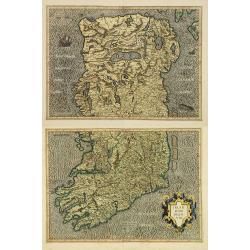
Irlandiae regnum. (2-sheets)
A early and large scale, two-sheet map of Ireland, which can be joined.The maps are richly engraved with a moiré pattern in the seas and strong topographical features in...
Date: Amsterdam, 1610
Selling price: ????
Please login to see price!
Sold in 2016
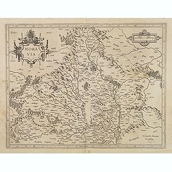
Moravia.
Detailed map centered on Brno. Moravia map, edited by Mercator and signed "Per Gerardum Mercatorem. Cum privilegio." in lower right corner, published by Jodocus...
Date: Amsterdam, c.1610
Selling price: ????
Please login to see price!
Sold in 2012
![Belgii inferioris descriptio: emendata cum circumiacentium regionu[m] confinijs: Zeelant insularum loca aliquo. . .](/uploads/cache/33486-250x250.jpg)
Belgii inferioris descriptio: emendata cum circumiacentium regionu[m] confinijs: Zeelant insularum loca aliquo. . .
One of the earliest maps of the Low Countries. Including now-a-days The Netherlands in the north to Luxembourg in the South, centered on Zeeland and the Rhine River.
Date: Amsterdam, 1610
Selling price: ????
Please login to see price!
Sold in 2020
Irlandiae Regnum.
Gerard Mercator's map of Ireland from the Mercator Hondius atlas with Latin text printed on the back. A fine, early map of Ireland with west at the top of the map. This i...
Date: Duisberg, Amsterdam, 1587-1610
Selling price: ????
Please login to see price!
Sold in 2015
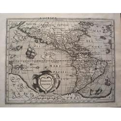
Americae Descrip.
Verso Latin text. An intricate and beautiful map of North and South America as well as parts of the Atlantic and Pacific Ocean.
Date: Amsterdam, ca. 1610
Selling price: ????
Please login to see price!
Sold in 2013
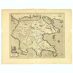
Morea olim Peloponnesus.
Early map of Peloponnesus, Greece.
Date: Amsterdam, 1610
Selling price: ????
Please login to see price!
Sold in 2014
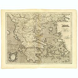
Graeciae.
Mercator's fine map of Greece, based on Nikolaus Sophianos (1500-1552). Map shows all of Greece including the islands and the Turkish coastline north of 35°. Renaissance...
Date: Amsterdam, 1610
Selling price: ????
Please login to see price!
Sold in 2015
![Tornaci Nervorum. Episcopatus Perantiquus Totaq. Tornacesii Ditio... Ion. Baptista Vrientius Antverp. Tabulam a se delineatam.. [One of the rarest of all Ortelius maps]](/uploads/cache/93996-250x250.jpg)
Tornaci Nervorum. Episcopatus Perantiquus Totaq. Tornacesii Ditio... Ion. Baptista Vrientius Antverp. Tabulam a se delineatam.. [One of the rarest of all Ortelius maps]
This exceptional rare map of Hainaut is a must for all collectors of Ortelius maps!!! The rarest of all Ortelius maps. Centered on Lille. The map has a dedication to Mich...
Date: Antwerp, ca. 1610
Selling price: ????
Please login to see price!
Sold in 2021
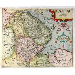
Lincolniae Comitatus Ubi Olim Insederunt Coritani.
A fine copper engraved map by William Kip, after Christopher Saxton. A map of Lincolnshire from the second edition of Philemon Holland’s translation of Camden’s Brit...
Date: London, 1610
Selling price: ????
Please login to see price!
Sold in 2016
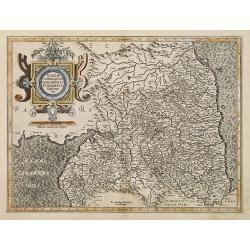
Brescia episcopatus Mediolanum ducatus.
Beautifully engraved small map covering Lombardy and the Lakes Garda and Como, naming the cities of Milan, Bergamo, Mantua, Brescia, and many others. Decorated with a sma...
Date: Amsterdam, ca. 1610
Selling price: ????
Please login to see price!
Sold in 2016
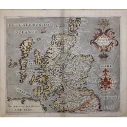
SCOTIA REGNUM
Second state map of Scotland 'SCOTIA REGNUM' By William Hole based on Christopher Saxton’s map of 1579, signed in the plate.A very attractive and decorative early 17th ...
Date: London, 1610
Selling price: ????
Please login to see price!
Sold in 2016
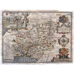
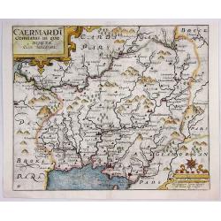
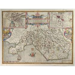
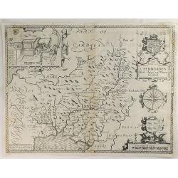
Caermarden, Both Shyre And Towne Described.
This is probably the most decorative map of Caermarden county. It has an inset plan of Caermarthen, two cartouches with armorials, wonderful compass rose and the Prince ...
Date: London, 1610
Selling price: ????
Please login to see price!
Sold in 2017
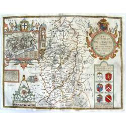
The Countie of Nottingham described. The Shire Townes Situation and the Earls there of observed.
From Speed's atlas, engraved by Jodocus Hondius. With inset plan of Nottingham. Huge, beautiful cartouche featuring putti with bow & arrows, pheasants, crown and co...
Date: London, Thomas Bassett and Richard Chiswell, 1610
Selling price: ????
Please login to see price!
Sold in 2015
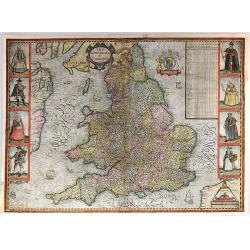
The Kingdome of England
The most famous and iconic map of England in the Stuart period. Rare first state of the map. Handsome copper engraved map from Speed's "Theatre of the Empire of Grea...
Date: London, 1610
Selling price: ????
Please login to see price!
Sold in 2015
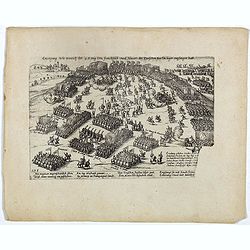
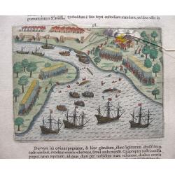
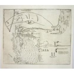
Erzeignung Wie Henrich der 4. Konig von Franckreich und Navarr, der Teutschen fursten lager empfangen hatt. Plate 278.
Plate from the series about the " Eighty Years' War" or the independence war of Holland against Spain, we know of approximately four hundred engravings by Frans...
Date: Cologne, ca. 1610
Selling price: ????
Please login to see price!
Sold in 2020
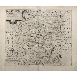
Radnor Comitatus quem Silvres.
A decorative map of the Welsh county of Radnorshire, in Mid-Wales, engraved by William Kip, after Christopher Saxton, for the second English edition of Camden's 'Britanni...
Date: London, 1610
Selling price: ????
Please login to see price!
Sold in 2017
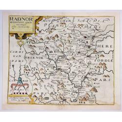
Radnor Comitatus Quem Silvres.
A decorative map of the Welsh county of Radnorshire, in Mid-Wales, engraved by William Kip, after Christopher Saxton, for the second English edition of Camden's 'Britanni...
Date: London, 1610
Selling price: ????
Please login to see price!
Sold in 2018
Caermardt Comitatus in Quo Dimetae.
A decorative map of the Welsh county of Caermarthen, in Wales, engraved by William Kip, after Christopher Saxton, for the second English edition of Camden's 'Britannia', ...
Date: London, 1610
Selling price: ????
Please login to see price!
Sold in 2017
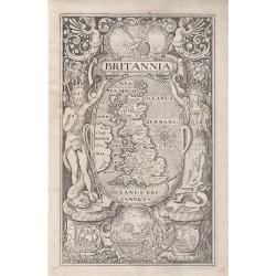
'Britannia' Frontispiece - William Camden.
Above the title, a cartouche depicting the figure of Britannia, with shield and spear, seated on a rock beside the sea. Below a map of Britain, inscribed with the Latin n...
Date: London, 1610
Selling price: ????
Please login to see price!
Sold in 2018
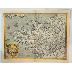
Britannia & Normandia cum Consinib Regionibus.
A Mercator & Hondius map of Brittany and Normandy, including part of Picardy. One of the earliest maps of Brittany and Normandy, it was first published by Mercator in...
Date: Amsterdam, 1610
Selling price: ????
Please login to see price!
Sold in 2017
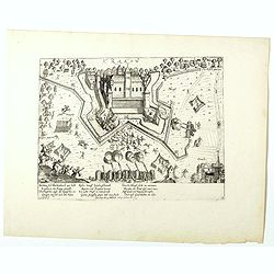
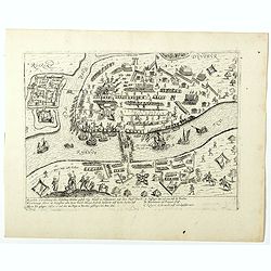
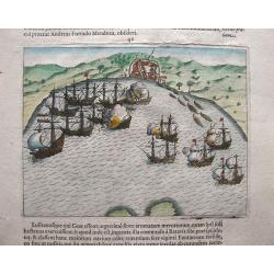
(Krakow Castle near Krefeld)
Rare print of Krakow Castle near Krefeld, besieged from November 4 1605 and captured by Spinola by the troops under the Count of Bucquoy on November 7, 1605.The plates by...
Date: Cologne, 1610
Selling price: ????
Please login to see price!
Sold in 2023
(Siege of the Rhine bridge by Duisburg)
Rare print of siege of the Rhine bridge by Duisburg captured by Spinola by the troops under the Count of Bucquoy on November, 1605.The plates by Hogenberg are dealing wit...
Date: Cologne, 1610
Selling price: ????
Please login to see price!
Sold in 2018
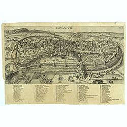
Lovanium.
Striking early view of Louvain (Leuven), engraved by Jodocus (Josse or Joost) Vander Baren in 1610.Very rare. Jodocus (also Joost or Josse) Van der Baren was a painter wh...
Date: Leuven, 1610
Selling price: ????
Please login to see price!
Sold in 2018
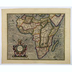
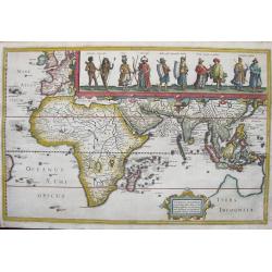
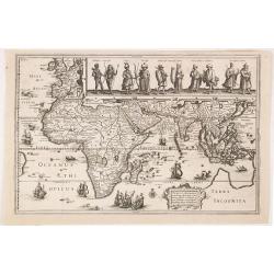
Africa Ex Magna orbis terre descriptione Gerardi Mercatoris desumpta, Studio & industria.
This magnificent old color map of Africa was one of the most influential maps of the continent of its time. This atlas version of the map was engraved by Gerard Mercator�...
Date: Amsterdam, ca 1610
Selling price: ????
Please login to see price!
Sold in 2021
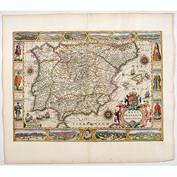
Nova Hispaniae descriptio.
Very rare second state of the Jodocus Hondius map, being the first carte-a-figures map of Spain and Portugal. With the imprint : Amsterdam Everardus Cloppenburghius excud...
Date: Amsterdam, 1610
Selling price: ????
Please login to see price!
Sold in 2022
Tabula geograph in qua Europaeae, Africaeae, Asiae aeq et circujacentium insularum oraeae maritimaeae accurate describuntur et ad jntelligentia navigationum Indicaru accommodantur
A rare and decoratively engraved map extending from western Europe to Japan with all Africa, Arabia and southern Asia prominent. Engraved by Jodocus Hondius the Elder. Th...
Date: Amsterdam, 1611
Selling price: ????
Please login to see price!
Sold in 2013
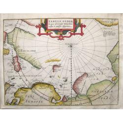
Tabula Geogr. in qua admirandae navigationis cursus et recursus designatur.
First state of a very early and scarce map of the North Pole and Arctic regions showing recent discoveries including the voyage of Jan Willem Barentsz on his quest to fin...
Date: Amsterdam, 1611
Selling price: ????
Please login to see price!
Sold in 2016
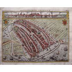
Amstelodamum Emporium
One of the oldest maps and views of Amsterdam, elegantly engraved by Jodocus Hondius the elder in 1611. The map depicts the view of Amsterdam in the beginning of its expa...
Date: Amsterdam, 1611
Selling price: ????
Please login to see price!
Sold in 2014
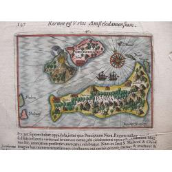
Tabula Geograph.
A finely engraved map by Jodocus Hondius for Johannes Pontanus Renum et Urbis Amstelodamensium Historia... being a history of Amsterdam but also including reports of vari...
Date: Amsterdam, Gilles Joosten Saegman, 1611
Selling price: ????
Please login to see price!
Sold in 2014
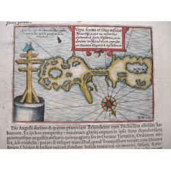
Vera forma et fitus ... (Nova Zembla and the Russian Cross.)
The map depicts an island to the north of Nova Zembla and the Russian Cross found on that island with its eight extremities. Drawn by Jan Huygen van Linschoten in 1594 du...
Date: Amsterdam, 1611
Selling price: ????
Please login to see price!
Sold in 2014
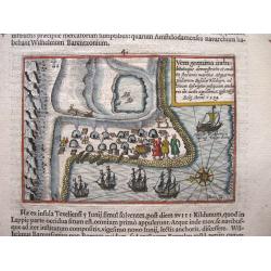
Vera Genuina, Island of Kilduyn.
Uncommon map of part of the coast along the Barents Sea with the island of Kilduyn, offshore of the river near the town of Cola (Murmansk). Made to illustrate Willem Bare...
Date: Amsterdam, 1611
Selling price: ????
Please login to see price!
Sold in 2014
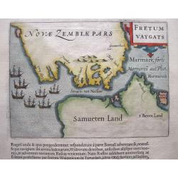
Fretum Vaygats.
The map depicts the southern part of Nova Zembla and the small passage called the Strait of Nassau, Straete van Nassau between Nova Zembla and the mainland of Russia. Dep...
Date: Amsterdam, 1611
Selling price: ????
Please login to see price!
Sold in 2014
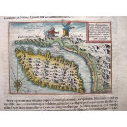
Vera delineatio insulae Ordinum quatuor circiter miliaribus a freto Nassovico distantis.
Map of the Strait of Nassau and Novaya Zemblya, here identified as Novae Zemblae Pars, in present-day Russia. We find the explorers attacked by a polar bear. The map inc...
Date: Amsterdam, 1611
Selling price: ????
Please login to see price!
Sold in 2014
Nova Zembla & Fretum Waygats.
Map of Novaya Zemblya, here identified as Nova Zembla, in present-day Russia. Includes beautiful ships, seals, a whale, a cartouche, a fine compass rose, and icebergs. Ev...
Date: Amsterdam, 1611
Selling price: ????
Please login to see price!
Sold in 2014
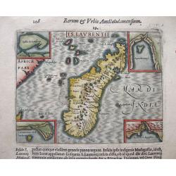
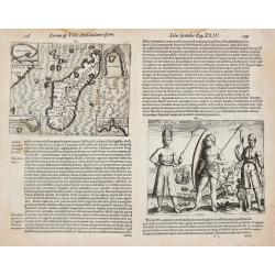
I.S. Laurentii. (Madagascar).
A highly detailed map of Madagascar with 4 insets with detail maps and a print on verso depicting the inhabitants of the island. Even though this map is much smaller than...
Date: Amsterdam, 1611
Selling price: ????
Please login to see price!
Sold in 2014
Baly and Java.
Map of Bali in present-day Indonesia. Includes inset of temple and temple grounds. Even though this map is much smaller than an atlas map from Blaeu, Hondius or Ortelius,...
Date: Amsterdam, 1611
Selling price: ????
Please login to see price!
Sold in 2014
The town of Madura on the island Madura: Madurensium
An early, rare view of the town of Madura on the island Madura with the 4 ships of Houtman's fleet. On verso the inhabitants are showing the Houtman’s crew their skills...
Date: Amsterdam, 1611
Selling price: ????
Please login to see price!
Sold in 2014
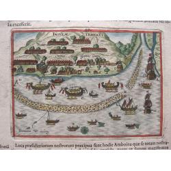
Banda isles - Banda, Poelepetacke and Groene Ape
Two early maps on one sheet. Amboina and the Banda Isles: Banda, Pulau Run and Gunung Api on the verso of the sheet. From the description by Pontanus of the second expedi...
Date: Amsterdam, 1611
Selling price: ????
Please login to see price!
Sold in 2014
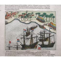
View of the town of Gammelamme, situated on Ternate.
View of the town of Gammelamme [Gamalama] on Ternate, where the Dutch established a trading post. Includes Dutch ships, native boats or proas, indication of the reef, nat...
Date: Amsterdam, 1611
Selling price: ????
Please login to see price!
Sold in 2020
Siege of Malacca.
Siege of Malacca by admiral Cornelis Matelief. Malacca is in the background. The Dutch go ashore with boats and march on the city. Even though this map is much smaller th...
Date: Amsterdam, 1611
Selling price: ????
Please login to see price!
Sold in 2014
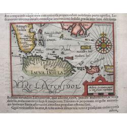
Java, Borneo and Southern Sumatra.
An early, rare and beautiful map of Java and the southern part of Sumatra and Borneo. Includes Bali and Cambava (present-day Mataram?). Also includes shoals. Fine calligr...
Date: Amsterdam, 1611
Selling price: ????
Please login to see price!
Sold in 2014
Goa
Very early view of Goa, India. An entire leaf from the book by Pontanus ‘Rerum et urbis Amstelodamensium Historia’ (1611). On verso a naval engagement.
Date: Amsterdam, 1611
Selling price: ????
Please login to see price!
Sold in 2023
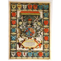
The Achievement of Our Soveraigne King James as he Nowe Beareth With the Armes of Severall kings that have aunciently raigned within his nowe Dominions
This is the frontispiece to John Speed's “The Theatre of the Empire of Great Britaine.” The central panel contains the Royal Arms, allegorical motifs including putti,...
Date: London, 1611
Selling price: ????
Please login to see price!
Sold in 2015
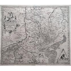
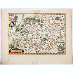
Limburgensis Ducatus Nova Descriptio.
An early and uncommon map of the former duchy of Limburg in what is today's Belgium and Holland, compiled by Agidio Martini in 1603.Martini, a mathematician in Antwerp, w...
Date: Amsterdam, c1611
Selling price: ????
Please login to see price!
Sold in 2016
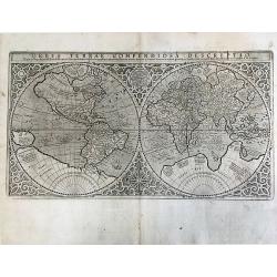
Orbis Terrae Compendiosa Descriptio.
Rumold Mercator's important world map with Latin text on the verso. This influential double-hemisphere world map was created by Rumold Mercator, based on the work of his ...
Date: Duisberg, 1587-1611
Selling price: ????
Please login to see price!
Sold in 2018
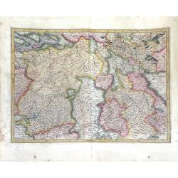
Mesopotamia Syrie.
This scarce map of the Eastern Mediterranean region extends throughout the Middle East and Egypt. Cyprus and the Levantine coasts are clearly detailed with particular att...
Date: Hannover 1611
Selling price: ????
Please login to see price!
Sold
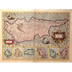
Cyprus Ins
From the "Gerardi Mercatoris Atlas sive Cosmographicae meditationes de fabrica mundi et fabricati figura denuò auctus". Latin text on verso. An elegant map of ...
Date: Amsterdam, c 1611
Selling price: ????
Please login to see price!
Sold
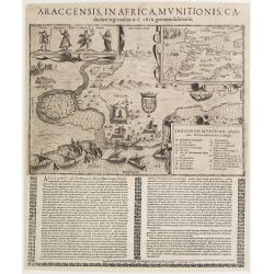
Araccensis in Africa, Munitionis catholico regi traditae..
Very rare so-called Einblatt druck of Morocco. In upper right hand corner inset map of Morocco and southern tip of Spain, Canaries and an over-sized Majorca. To the left ...
Date: Augsburg 1611
Selling price: ????
Please login to see price!
Sold
I.S. Laurentii. / Rex Ins. S. Maria Indigenarum I.S. Laurentii imagines.
Johan Isaac Pontanus. Rerum et Urbis Amstelodamensium historia, with descriptions of the voyages made by the Dutch to Novoya Zemlya and the first voyage of the Dutch to t...
Date: Amsterdam, 1611
Selling price: ????
Please login to see price!
Sold
Mauritius.
From J.A.Pontanus\' \'Rerum et urbis Amstelodamensium historia\'. Description of the first voyage of the Dutch to the East Indies under command of Houtman.
Date: Amsterdam, 1611
Selling price: ????
Please login to see price!
Sold
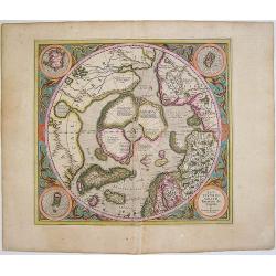
Septentrionalium Terrarum descriptio
This influential map was the first separately printed map devoted to the Arctic. The hemisphere is surrounded by a floral design with four roundels in each corner. These ...
Date: Amsterdam, 1611
Selling price: ????
Please login to see price!
Sold in 2011
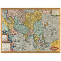
Asiae Nova Descriptio Auctore Jodoco Hondio.
Hondius Asia map in full colors.
Date: Amsterdam, 1611
Selling price: ????
Please login to see price!
Sold in 2009
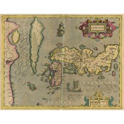
Iaponia.
A close derivative of the Teixeira map introduced by Ortelius in 1595. Hondius, however, makes note of Korea by including an inscription stating that it is not known whet...
Date: Amsterdam, 1611
Selling price: ????
Please login to see price!
Sold in 2010
The Bishoprick and Citie of Durham.
A beautiful first edition John Speed map of Co. Durham.Aesthetically, it is considered one of the most accomplished maps in the 'Theatre', noted for its clarity and featu...
Date: London, 1611
Selling price: ????
Please login to see price!
Sold in 2023
-250x250.JPG)
Kent with her Cities and Earls Described and Observed
A rare highly decorative and finely engraved early 17th-century map of Kent was published in John Speed's Theatre of the Empire of Great Britaine. The inset plans of Cant...
Date: London, 1611
Selling price: ????
Please login to see price!
Sold in 2022
Glamorgan Shyre with the Sittuations of the Chiefe Townd Cardyff and Ancient Landaffe Described.
A nice full color example of John Speed's map of the County of Glamorgan, in south Wales, including coats of arms and a detailed town plan of Cardiff and the town of Land...
Date: London, 1612
Selling price: ????
Please login to see price!
Sold in 2019
Caermarden both Shyre and Towne Described.
This is probably the most decorative map ever produced concerning the Welsh county of Caermarden (Carmarthenshire). It has an inset plan of Caermarthen, two cartouches w...
Date: London, 1612
Selling price: ????
Please login to see price!
Sold in 2019
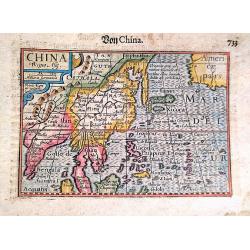
China Regio Asie / Von China.
An attractive example of Barent Langenes's map of China and neighbouring countries, which first appeared in the 1598 edition of Langenes's 'Caert-Thresoor'. This example ...
Date: Amsterdam, 1612
Selling price: ????
Please login to see price!
Sold in 2020
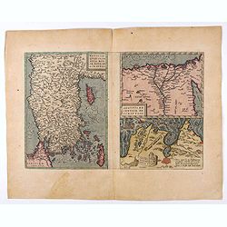
Natoliae. . .Aegypti recentior..Carthaginis (3 maps on 1 sheet).
Rare. Three maps on one sheet. Map to the left east to the top. Detailed map Turkey, including Cyprus and Crete. Also map of the Nile delta and another map of Tunis.
Date: Antwerp, 1608-1612
Selling price: ????
Please login to see price!
Sold in 2020