Browse Listings
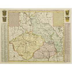
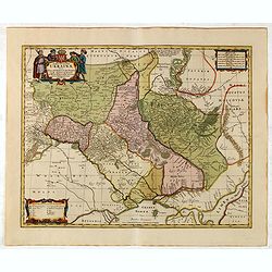
Carte du Royaume de Boheme. La chronologie de ses Rois..
Map centered on today Czech Republic, including part of Poland with a key table to the towns on both sides.Zacharie Chatelain (d.1723) was the father of Henri Abraham (16...
Date: Amsterdam, ca. 1720
Selling price: ????
Please login to see price!
Sold
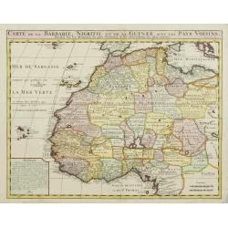
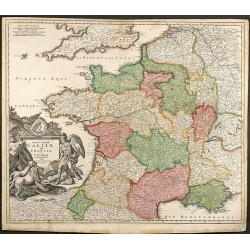
Carte de la Barbarie, Nigritie, et de la Guinée?
Map of North and West Africa, including the Canary Islands, the Cape Verde Islands and the Azores. According to the title "drawn up from early 18th century reports a...
Date: Amsterdam, ca. 1720
Selling price: ????
Please login to see price!
Sold
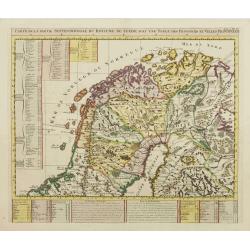
Carte de la Partie Septentrionale du Royaume de Suede?
Map of the northern part of Scandinavia. It covers the area straddling Norway, Sweden, Finland and Russia.Zacharie Chatelain (d.1723) was the father of Henri Abraham (168...
Date: Amsterdam, ca. 1720
Selling price: ????
Please login to see price!
Sold
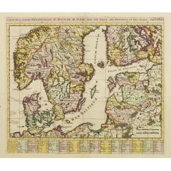
Carte de la Partie Meridionale du Royaume de Suede?
Map of the southern part of Scandinavia with letter key at the bottom.Zacharie Chatelain (d.1723) was the father of Henri Abraham (1684-1743) and Zacharie Junior (1690-17...
Date: Amsterdam, ca. 1720
Selling price: ????
Please login to see price!
Sold
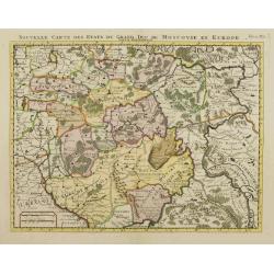
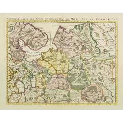
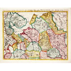
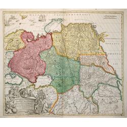
Nouvelle Carte des Etats du Grand Duc de Moscovie en Europe. Partie Meridionale.
Detailed map of central Russia. Moscow in the centre of the map, including Rzeva, Ukraine, Astracan, etc.Zacharie Chatelain (d.1723) was the father of Henri Abraham (1684...
Date: Amsterdam, ca. 1720
Selling price: ????
Please login to see price!
Sold
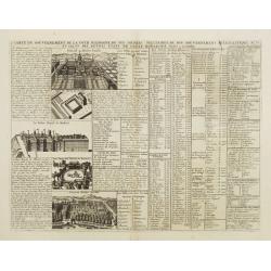
Carte du Gouvernement de la Cour d'Espagne..
This impressive engraving is a wonderful example of Chatelain's elegant plates. Ornamented with numerous vignettes.It provides a detailed description of the infrastructur...
Date: Amsterdam, ca. 1720
Selling price: ????
Please login to see price!
Sold in 2012
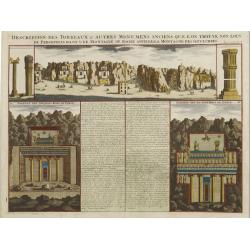
Description des Tombeaux & autres Monumens Anciens..
This impressive engraving is a wonderful example of Chatelain\'s elegant plates.Ornamented with views representing burial monuments and mausoleums hewed out in the rock a...
Date: Amsterdam, ca. 1720
Selling price: ????
Please login to see price!
Sold in 2009
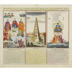
Description d'un des plus fameux temples des Chinois..
This impressive engraving is a wonderful example of Chatelain?s elegant plates.Divided in 3 panels, respectively showing the most important gods in the Chinese deities sy...
Date: Amsterdam, ca. 1720
Selling price: ????
Please login to see price!
Sold
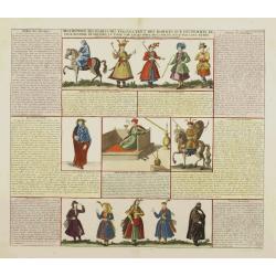
Description des habits des Persans..
This impressive engraving is a wonderful example of Chatelain\'s elegant plates.Ornamented with numerous vignettes showing the costumes of the ancient Persians.General in...
Date: Amsterdam, ca. 1720
Selling price: ????
Please login to see price!
Sold in 2009
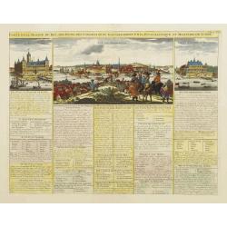
Carte de la Maison du Roi, des Etats.. de Suede.
This impressive engraving is a wonderful example of Chatelain?s elegant plates. Ornamented with 3 vignettes: Palais du Roi de Suede, Vuë de Stockholm, Vuë du château d...
Date: Amsterdam, ca. 1720
Selling price: ????
Please login to see price!
Sold in 2009
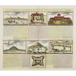
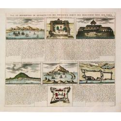
Vue et Description de quelques-uns des principaux forts des Hollandois..
This impressive engraving is a wonderful example of Chatelain's elegant plates.Ornamented with numerous vignettes representing some of the Dutch settlements in the East I...
Date: Amsterdam, ca. 1720
Selling price: ????
Please login to see price!
Sold in 2008
Etat abregé de la Maison du Grand Seigneur..
This impressive engraving is a wonderful example of Chatelain?s elegant plates. Ornamented with 3 vignettes: Vuë du Serrail de Constantinople, Vuë de Constantinople, Vu...
Date: Amsterdam, ca. 1720
Selling price: ????
Please login to see price!
Sold

Habillement de l'Empereur de la Chine & des Dames de son Palais..
This impressive engraving is a wonderful example of Chatelain?s elegant plates.Divided in 3 panels, showing examples of costumes of Chinese ladies and those of the king o...
Date: Amsterdam, ca. 1720
Selling price: ????
Please login to see price!
Sold
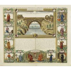
Habillemens d'Hommes et Femmes de diverses provinces de Chine..
This impressive engraving is a wonderful example of Chatelain?s elegant plates.Very nice view representing a bridge in the upper central part. Surrounded with panels show...
Date: Amsterdam, ca. 1720
Selling price: ????
Please login to see price!
Sold
Nouvelle Carte des Etats du Grand Duc de Moscovie en Europe. Partie Sertentrionale.
Northern part of European Russia. Zacharie Chatelain (d.1723) was the father of Henri Abraham (1684-1743) and Zacharie Junior (1690-1754).They worked as a partnership pub...
Date: Amsterdam, ca. 1720
Selling price: ????
Please login to see price!
Sold
Carte generale des Etats du Czar. Empereur de Moscovie, ou L'on voit ce que ce prince possede en Europe ..
Impressive map of Russia Tartary and part of China with key tables to the towns. Depicting the different states belonging to the Czar in Asia and Europe, showing the path...
Date: Amsterdam, ca. 1720
Selling price: ????
Please login to see price!
Sold
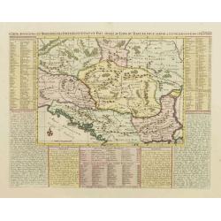
Carte ancienne et moderne des differents et Païs situez au long du Danube, pour servir a l'intelligence de l'histoire.
Handsome map of the Balkans showing the various historical regions with explanatory text and tables on three sides. The map focuses on the Danube valley, which is the mos...
Date: Amsterdam, ca. 1720
Selling price: ????
Please login to see price!
Sold
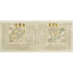
Carte génealogique pour conduire à l'Histoire des Rois du Nord, la Carte de leurs états, leurs Armes ..
Large fold out map which traces the genealogy of the royal families of Scandinavia. The royal lineage of Norway, Denmark, and Sweden are all carefully laid out across the...
Date: Amsterdam, ca. 1720
Selling price: ????
Please login to see price!
Sold
Nouvelle Carte des Etats du Grand Duc de Moscovie en Europe partie Septentrionale.
H.A. Chatelain's attractive map of the northern part of European Russia.
Date: Amsterdam, c. 1720
Selling price: ????
Please login to see price!
Sold
Vue et description de quelques-uns des principaux forts des Hollandois dans les Indes.
Henri Abraham Chatelain was a Amsterdam-based geographer and publisher. His main product is the 'Atlas Historique et Méthodique', in seven volumes, published between 171...
Date: Amsterdam, 1710-1720
Selling price: ????
Please login to see price!
Sold in 2010
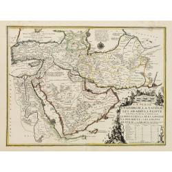
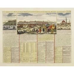
La Perse, La Georgie, LA Natolie, Les Arabies, L'Egipte et le Cours du Nile..
A regional map showing the Asian territories of Ottoman Empire with emphasis on the course of river Nile.The map has an elaborate cartouche showing the ethnic population ...
Date: Paris, 1720
Selling price: ????
Please login to see price!
Sold in 2008
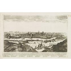
Dantzick.
A very RARE panoramic view of Danzig, including a numbered legend in the lower part.The plate is numbered in red pencil in upper right corner.Engraved by Jean Crepy (the ...
Date: Paris, 1690-1720
Selling price: ????
Please login to see price!
Sold in 2008
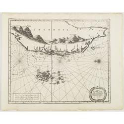
l'Isle de Formosa ou sont exactement marquez les bancs de Sables . . .
A decorative map of the west coast of Taiwan and the Pescadores Islands (Penghu), showing little detail of the Taiwanese inland, apart from the immense mountain range. Fo...
Date: Leiden, 1720
Selling price: ????
Please login to see price!
Sold in 2008
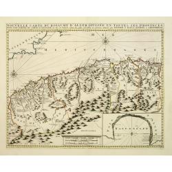
Nouvelle carte du Roiaume D\'Alger divisée en toutes ses provinces, avec une partie due cotes D\'Espagne . . .
Rare and detailed map of the coast of Algeria. Large inset map of the Bay of Alger (El-Jazir). Shows a coastline of Spain around Alicante. Two compass roses in the Medite...
Date: Amsterdam, 1720
Selling price: ????
Please login to see price!
Sold in 2012
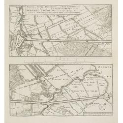
Nieuwe en nette afteekening van de door Gravinge die er Staat. . . Stadt Utrecht tot aan Spakenborg in de Zuyder Zee . . .
New and accurate map of the canal from the city of Utrecht to Spakenburg. The map was published in : Het groote tafereel der dwaasheid : vertoonende de opkomst, voortgang...
Date: Amsterdam, 1720
Selling price: ????
Please login to see price!
Sold
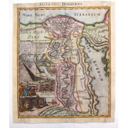
Aegyptus Hodierna.
Highly decorative map depicting the Nile River. Large vignette featuring the pyramids, Sphinx, tombs of the kings and waterfall. Johann Baptist Homann (1664 – 1724) wa...
Date: Nuremberg, 1720
Selling price: ????
Please login to see price!
Sold in 2013
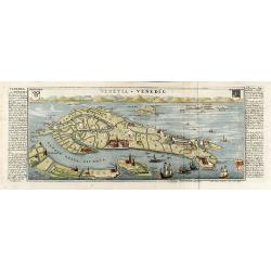
VENETIE, GELEGEN IN DE HADRIATISCHE ZEE IN VERSCHEIDE EILANDEN AFGEDEELT
Rare view of Venice by Pieter Schenk.
Date: Amsterdam, 1720
Selling price: ????
Please login to see price!
Sold in 2018
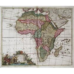
Africa --- mauro percussa Oceano, Niloque admota tepenti....Cum Privilegio ordinum Hollandia et Westfrisia.
An attractive map of Africa containing many of the striking characteristics of Dutch cartography of Africa from around this period. The cartouche in this map is the same...
Date: Amsterdam, c. 1720
Selling price: ????
Please login to see price!
Sold in 2013
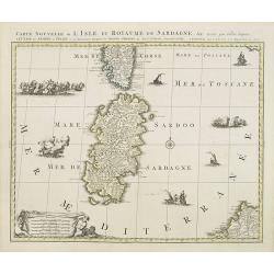
Carte nouvelle de l'Isle et royaume de Sardagne. . .
Uncommon map of Sardinia, with part of Corsica, the second-largest island in the Mediterranean Sea and an autonomous region of Italy. The Mediterranean is filled with sin...
Date: Amsterdam, 1720
Selling price: ????
Please login to see price!
Sold in 2023
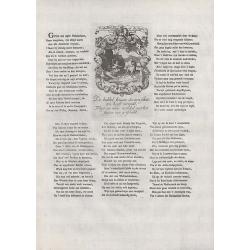
De Bubbel Jonge op de Jagt.
Text page with copper engraving (150 x 100mm.) taken from Het groote tafereel der dwaasheid : vertoonende de opkomst, voortgang en ondergang der actie, bubbel en windnego...
Date: Amsterdam, 1720
Selling price: ????
Please login to see price!
Sold in 2008
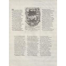
Het hobbelend Actiescheepje van Madame Compagnie en Monsieur Bubbels.
Text page with copper engraving (150 x 100mm.) taken from Het groote tafereel der dwaasheid : vertoonende de opkomst, voortgang en ondergang der actie, bubbel en windnego...
Date: Amsterdam, 1720
Selling price: ????
Please login to see price!
Sold in 2008
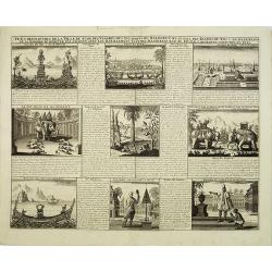
Vue & description de la ville de Siam, des pagodes, des Talapoins ou religieux de ce pais. . .
This impressive engraving is a wonderful example of Chatelain?s elegant plates.Exhaustive information about each scene is given in lengthy tables.Zacharie Chatelain (d.17...
Date: Amsterdam, ca. 1720
Selling price: ????
Please login to see price!
Sold in 2008
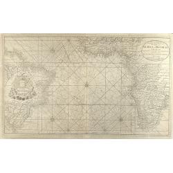
Nieuwe Wassende Graadige Pas-kaart van de Kust van Guinea en Brasilia strekkende van Cap-Verde tot de Cap de Bon-Esperance en Verders van Rio de Berbice tot Rio de la Plata te Amsterdam by Joannes van Keulen
Very large scale sea chart of the Atlanic Ocean from J. van Keulen. Showing the west coast of Africa down to South Africa and Brasil in the West. Exceptional for a nautic...
Date: Amsterdam, 1720
Selling price: ????
Please login to see price!
Sold in 2008

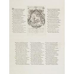
Het uitgeteerde en ftervende Actie boomtje.
Text page with copper engraving (150 x 100mm.) taken from Het groote tafereel der dwaasheid : vertoonende de opkomst, voortgang en ondergang der actie, bubbel en windnego...
Date: Amsterdam, 1720
Selling price: ????
Please login to see price!
Sold in 2008
Spiegel der Reden Voor de Wanhopende Actionisten.
Text page with copper engraving (150 x 100mm.) taken from Het groote tafereel der dwaasheid : vertoonende de opkomst, voortgang en ondergang der actie, bubbel en windnego...
Date: Amsterdam, 1720
Selling price: ????
Please login to see price!
Sold in 2008
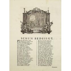
Schyn Bedriegt.
Text page with in top copper plate engraving (150 x 190mm.) taken from Het groote tafereel der dwaasheid : vertoonende de opkomst, voortgang en ondergang der actie, bubbe...
Date: Amsterdam, 1720
Selling price: ????
Please login to see price!
Sold in 2008

Hispaniae et Portugalliae regna per Nicolaum Visscher
Outstanding example of an Iberian peninsula map showing Spain and Portugal and Balearic Islands. Two beautiful cartouches with several putti and coat of arms. Published b...
Date: Amsterdam, 1720
Selling price: ????
Please login to see price!
Sold in 2009
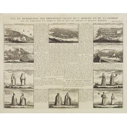
Vue et dscription des principales villes de l'Armenie et de la Georgie avec les habillements des femmes du pays, et ceux des prêtres et religieux armeniens. . .Tom: V N° 11 Pag: 28
View and description of the principal Armenian and Georgian cities with illustrations of Armenian women's garments as well as priests' and monks' clothing. The views are ...
Date: Amsterdam, ca 1720
Selling price: ????
Please login to see price!
Sold in 2013
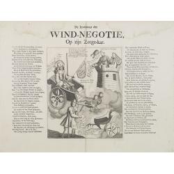
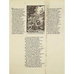
De Inventeur der Wind - Negotie, Op zijn Zeege-kar.
Decorative print satirizing the stock exchange business after it collapse in the beginning of the 18th century, that led to the complete ruin of many of over-eager French...
Date: Amsterdam, 1720
Selling price: ????
Please login to see price!
Sold in 2009
De malle actionisten naar Vianen of 't Peperland.
Decorative print satirizing the stock exchange business after it collapse in the beginning of the 18th century, that led to the complete ruin of many of over-eager French...
Date: Amsterdam, 1720
Selling price: ????
Please login to see price!
Sold in 2008
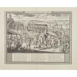
Law, als een tweede Don Quichot, op sanches Graauwtje zit ten spot.
Decorative print satirizing John Law and his investment schemes; with an etching showing a crowd of people, in the center John Law and mounted on a donkey which is pulled...
Date: Amsterdam, 1720
Selling price: ????
Please login to see price!
Sold in 2008
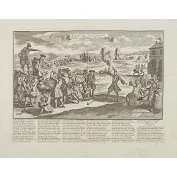
Vytslag der wind negotie.
Decorative print satirizing the stock exchange business after it collapse in the beginning of the 18th century, that led to the complete ruin of many of over-eager French...
Date: Amsterdam, 1720
Selling price: ????
Please login to see price!
Sold in 2008
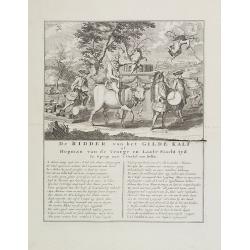
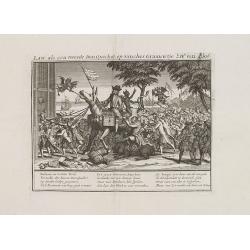
De Ridder van het Gilde Kalf of Hopman van de Vroege en Laate Slacht tyd in optogt naar 't Orakel van Delfos.
Decorative print satirizing the stock exchange business after it collapse in the beginning of the 18th century, that led to the complete ruin of many of over-eager French...
Date: Amsterdam, 1720
Selling price: ????
Please login to see price!
Sold in 2008

Kermis wind-kraamer en grossier - La Monopole des Vents.
Decorative print satirizing the stock exchange business after it collapse in the beginning of the 18th century, that led to the complete ruin of many of over-eager French...
Date: Amsterdam, 1720
Selling price: ????
Please login to see price!
Sold in 2008
Sy overwint de min. . . .
Decorative print satirizing the stock exchange business after it collapse in the beginning of the 18th century, that led to the complete ruin of many of over-eager French...
Date: Amsterdam, 1720
Selling price: ????
Please login to see price!
Sold in 2008
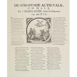
De stropende actie-valk, omhals, En 't Bubbel-Rotje onder de klaauwen van den UIL.
Decorative print satirizing the stock exchange business after it collapse in the beginning of the 18th century, that led to the complete ruin of many of over-eager French...
Date: Amsterdam, 1720
Selling price: ????
Please login to see price!
Sold in 2008

Portraits du Grand Seigneur et des Principaux Officiers de l'Empire Ottoman. . .
These four impressive engravings are a wonderful example of Chatelain's elegant plates.Divided in 4 panels accompanied by detailed descriptions, are examples of costumes ...
Date: Amsterdam, ca. 1720
Selling price: ????
Please login to see price!
Sold in 2008
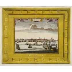
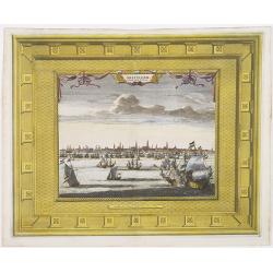
Amsterdam Capitale de la Hollande.
A panoramic view of the town of Amsterdam seen from 't IJ. Set within a decorative border, printed from a separate plate.Uncommon.
Date: Leiden, 1720
Selling price: ????
Please login to see price!
Sold in 2008
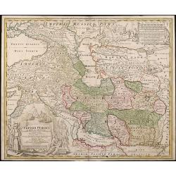
Imperii Persici In Omnes Suas Provincias
Hand colored copper engraving by J.B. Homann, showing Persia between Astrakhan, Kabul, Arabic Sea and Cyprus.
Date: Nuremberg, 1720
Selling price: ????
Please login to see price!
Sold in 2008
Ducatus Luxemburgi tam in Maiores quam Minores ejusdem Ditiones accurate distinctus et exhibitus a Ioh. Bapt. Homanno Norimbergae
Old colored map of Luxembourg by J. B. Homann. With one decorative cartouche.
Date: Nuremberg, 1720
Selling price: ????
Please login to see price!
Sold in 2009
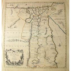
Aegyptus Antiqua Divisa in Nomos.
Very interesting copper engraved map of Northern Egypt and parts of Lybia, showing the are from the Mediterranean Sea with the Nile delta and Alexandria, to the Red Sea, ...
Date: Amsterdam, c1720
Selling price: ????
Please login to see price!
Sold in 2011
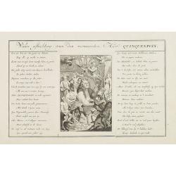
Waare afbeelding van den vermaarden Heer Quinquenpoix.
Page taken from Het groote tafereel der dwaasheid : vertoonende de opkomst, voortgang en ondergang der actie, bubbel en windnegotie, in Vrankryk, Engeland, en de Nederlan...
Date: Amsterdam, 1720
Selling price: ????
Please login to see price!
Sold in 2008
Totius Regni Galliae Sive Franciae et Navarrae novi¯ima Tabula edita Ó Io. Bapt. Homann Norimbergae
Copper engraved map of France by J. B. Homann. Covering complete France and southern part of the British Isles with many detail and one beautiful dramatic cartouche.
Date: Nuremberg, 1720
Selling price: ????
Please login to see price!
Sold in 2009
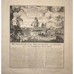
De Laggende Law, De Treurende Actionist..
A satire print taken from "Het groote tafereel der dwaasheid : vertoonende de opkomst, voortgang en ondergang der actie, bubbel en windnegotie, in Vrankryk, Engeland...
Date: Amsterdam, 1720
Selling price: ????
Please login to see price!
Sold in 2008
De verslagen actionist in de stoel met rinkels..
A satire print taken from "Het groote tafereel der dwaasheid : vertoonende de opkomst, voortgang en ondergang der actie, bubbel en windnegotie, in Vrankryk, Engeland...
Date: Amsterdam, 1720
Selling price: ????
Please login to see price!
Sold in 2008
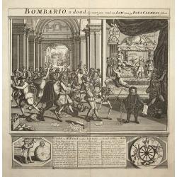
Bombario, o dood..
A satire print taken from "Het groote tafereel der dwaasheid : vertoonende de opkomst, voortgang en ondergang der actie, bubbel en windnegotie, in Vrankryk, Engeland...
Date: Amsterdam, 1720
Selling price: ????
Please login to see price!
Sold in 2008
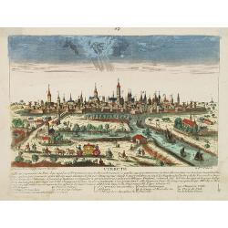
Utrecht.
A very RARE panoramic view of the city of Utrecht, including a numbered legend in the lower part.Engraved by Jean Crepy (the father) who was active as an engraver and pub...
Date: Paris, 1690-1720
Selling price: ????
Please login to see price!
Sold in 2008
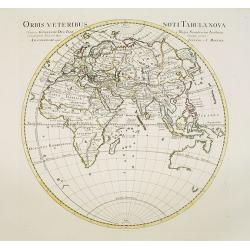
Orbis Veteribus Noti Tabula Nova.
Map of the Eastern Hemisphere, including Australia, with the tip of Diemensland. Japan's Honshu is called Satyrorum , and Kyushu Insulae Tres.The map is most interesting ...
Date: Amsterdam, 1720
Selling price: ????
Please login to see price!
Sold in 2017
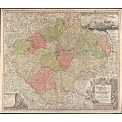
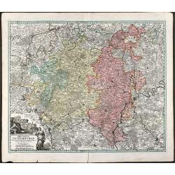
Bohemia Regnum juxta XII. Circulos divisum, cum Comitatu Glacensi et ditione Egrana, nec non confinibus Provinciis in mappa Geographica accurati¯ime delineatum per Matthaeum Seutter
Large original old colored map of Bohemia by M. Seutter. With two decorative cartouches and a city view of Carlsbad. Centered around Prague (Praha).
Date: Augsburg, 1720
Selling price: ????
Please login to see price!
Sold in 2009
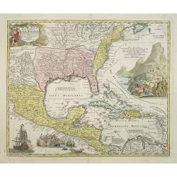
Regni Mexicani seu Novae Hispaniae, Floridae, Novae ..
The map shows the eastern sea board of America, the West Indies and the various estates and countries that border the Gulf of Mexico, with decorative cartouches. The map ...
Date: Nuremberg 1720
Selling price: ????
Please login to see price!
Sold in 2009
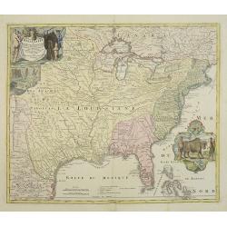
Amplissimae Regionis Mississipi,.. Provinciae Ludovicianae..
Attractive map of present-day U.S. from Nouveau Mexico to the Atlantic, centering on the French province of Louisiana, with the English colonies and Spanish Florida indic...
Date: Nuremberg 1720
Selling price: ????
Please login to see price!
Sold in 2009

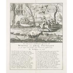
De kornet van vuil gewin of wortel en besse postiljon op zyn mager, doch niewlyks gemest varken uitschreewende de kompany is vol.
Print taken from Het groote tafereel der dwaasheid : vertoonende de opkomst, voortgang en ondergang der actie, bubbel en windnegotie, in Vrankryk, Engeland, en de Nederla...
Date: Amsterdam, 1720
Selling price: ????
Please login to see price!
Sold in 2009
Typus Generalis Ukrainae sive Palatinatuum Podoliae, Kioviensis et Braczlaviensis terras nova delineatione exhibens. . .
Keymap based on Guillaume La Vasseur de Beauplan's map of the region published in "Description d'Ukraine". The work described Ukraine as several provinces of th...
Date: Amsterdam, ca. 1720
Selling price: ????
Please login to see price!
Sold in 2022
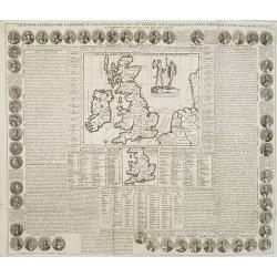
Carte Pour l'Introduction a l'Histoire d'Angleterre, ou l'on Voit son Premier Gouvernement, et l'Etat Abrege de cette Monarchie sous les Empereurs Romains, et sous les Rois Saxons.
The sheet includes a large inset map of Roman Britain including the English Channel and the western coast of France (200 x 255mm.). It also provides a wealth of informati...
Date: Amsterdam, 1720
Selling price: ????
Please login to see price!
Sold in 2009
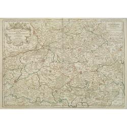
Le Comté de Haynaut, Divisé en Chatellenies, Balliages, Prevostés. Le Cambresis. Dédié au Roy . . .
Map of the county of Hainaut with its most important cities, Mons (Bergen), Cambrai (Kamerijk) and Charleroi. Also including Hainaut, who territorially is divided between...
Date: Paris, 1720
Selling price: ????
Please login to see price!
Sold in 2010
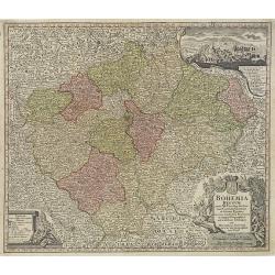
Bohemia Regnum juxta XII. Circulos divisum, cum Comitatu Glacensi et ditione Egrana, nec non confinibus Provinciis in mappa Geographica accuratissime delineatum per Matthaeum Seutter.
Decorative and uncommon map of Bohemia by M. Seutter. With two decorative cartouches and a city view of Carlsbad, with a numbered key. Centered around Prague.
Date: Augsburg, 1720
Selling price: ????
Please login to see price!
Sold in 2010
Amsterdam Capitale de la Hollande.
A panoramic view of the town of Amsterdam seen from 't IJ. Set within a decorative border, printed from a separate plate. Rare.
Date: Leiden, 1720
Selling price: ????
Please login to see price!
Sold in 2009
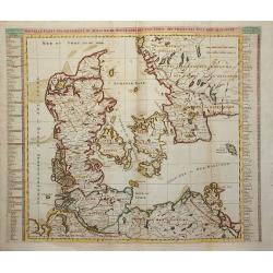
Nouvelle Carte Geographique du Royaume de Dannemarck avec une table des villes les plus remarquables.
Map of Denmark with a key table to the towns on both sides.Zacharie Chatelain (d.1723) was the father of Henri Abraham (1684-1743) and Zacharie Junior (1690-1754).They wo...
Date: Amsterdam, ca. 1720
Selling price: ????
Please login to see price!
Sold in 2011
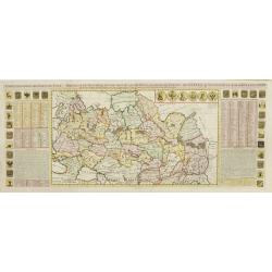
Generalis totius Imperii Moscovitici ?
Decorated title cartouche includes several classical, allegorical and historical figures. Illustrations on map include two masted ships, four boats, and two sea creatures...
Date: Nuremberg, 1720
Selling price: ????
Please login to see price!
Sold in 2009
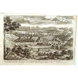
Bude Ville capitale de la Hongrie.
A rare panoramic of Budapest.The plate is numbered in red pencil in upper right corner.Engraved by Pierre Aveline (Paris, c.1656 - 23 May 1722). He was also a print-publi...
Date: Paris, 1690-1720
Selling price: ????
Please login to see price!
Sold in 2009
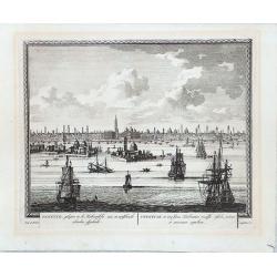
Venetia - Venedig
Beautiful colored birdeye view of Venice by Gabriel Bodenehr. Showing the important buildings, several sailing ships and German description on both sides. Printed from tw...
Date: Augsburg, 1720
Selling price: ????
Please login to see price!
Sold in 2010
![Nouvelle carte de la Suisse. Divisée en ses treize cantons. . . [4 sheets]](/uploads/cache/01476-250x250.jpg)
Nouvelle carte de la Suisse. Divisée en ses treize cantons. . . [4 sheets]
Prepared by Johann Jakob Scheuchzer (1672-1733), physician and geographer of Zürich. In 1712 he published a map of Switzerland in four sheets (scale 1/290,000), of which...
Date: Amsterdam, 1720
Selling price: ????
Please login to see price!
Sold in 2011
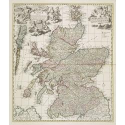
Exactissima Regni Scotiae Tabula tam in septentrionalem et meriodionalem quam in minores earundem provincias insulesq, et undique praetensas accurate . , ,
A magnificent and detailed map of Scotland, with all the counties, cities and towns, castles and churches, lochs, rivers and streams shown. This example with the imprint ...
Date: Amsterdam, 1690 -1720
Selling price: ????
Please login to see price!
Sold in 2018
De kornet van vuil gewin of wortel en besse postiljon op zyn mager, doch niewlyks gemest varken uitschreewende de kompany is vol.
Print taken from Het groote tafereel der dwaasheid : vertoonende de opkomst, voortgang en ondergang der actie, bubbel en windnegotie, in Vrankryk, Engeland, en de Nederla...
Date: Amsterdam, 1720
Selling price: ????
Please login to see price!
Sold
![De inventeur der Wind-Negotie, Op zijn Zeege-kar. [The inventor of stock-jobbery in his triumphal car.]](/uploads/cache/27964-250x250.jpg)
De inventeur der Wind-Negotie, Op zijn Zeege-kar. [The inventor of stock-jobbery in his triumphal car.]
Page taken from Het groote tafereel der dwaasheid : vertoonende de opkomst, voortgang en ondergang der actie, bubbel en windnegotie, in Vrankryk, Engeland, en de Nederlan...
Date: Amsterdam, 1720
Selling price: ????
Please login to see price!
Sold
![Quincampoix in duigen. [Quinquampoix destroyed.]](/uploads/cache/27966-250x250.jpg)
Quincampoix in duigen. [Quinquampoix destroyed.]
Quinquampoix destroyed, taken from Het groote tafereel der dwaasheid : vertoonende de opkomst, voortgang en ondergang der actie, bubbel en windnegotie, in Vrankryk, Engel...
Date: Amsterdam, 1720
Selling price: ????
Please login to see price!
Sold in 2009
![De Ridder van het Gilde Kalf of Hopman van de Vroege en Laate Slacht tyd in Optogt naar ' t Orakel van Delfos. [The chevalier of the Golden Calf, or captain of the early and late time of slaughtering, in procession to the Oracle of Delphos.]](/uploads/cache/27967-250x250.jpg)
De Ridder van het Gilde Kalf of Hopman van de Vroege en Laate Slacht tyd in Optogt naar ' t Orakel van Delfos. [The chevalier of the Golden Calf, or captain of the early and late time of slaughtering, in procession to the Oracle of Delphos.]
Page taken from Het groote tafereel der dwaasheid : vertoonende de opkomst, voortgang en ondergang der actie, bubbel en windnegotie, in Vrankryk, Engeland, en de Nederlan...
Date: Amsterdam, 1720
Selling price: ????
Please login to see price!
Sold
![De laggende Law, de treurende actionist met de smekende Mercurius. [Law laughing, the shareholders mourning, and Mercury entreating.]](/uploads/cache/27968-250x250.jpg)
De laggende Law, de treurende actionist met de smekende Mercurius. [Law laughing, the shareholders mourning, and Mercury entreating.]
Page taken from Het groote tafereel der dwaasheid : vertoonende de opkomst, voortgang en ondergang der actie, bubbel en windnegotie, in Vrankryk, Engeland, en de Nederlan...
Date: Amsterdam, 1720
Selling price: ????
Please login to see price!
Sold
![De Stropende Actie-Valk, Om Hals, En't Bubbel-Rotje onder de klaauwen van den Uil. [The strapping share-hawk pierced and the bubble rat between the claws of the owl.]](/uploads/cache/27969-250x250.jpg)
De Stropende Actie-Valk, Om Hals, En't Bubbel-Rotje onder de klaauwen van den Uil. [The strapping share-hawk pierced and the bubble rat between the claws of the owl.]
Page taken from Het groote tafereel der dwaasheid : vertoonende de opkomst, voortgang en ondergang der actie, bubbel en windnegotie, in Vrankryk, Engeland, en de Nederlan...
Date: Amsterdam, 1720
Selling price: ????
Please login to see price!
Sold
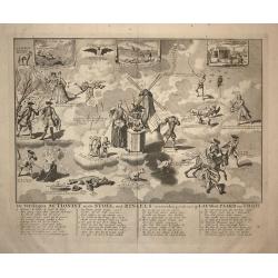
![De verwarde actionisten torenbouw tot Babel. [The Babel tower of the confused stock-jobbers.]](/uploads/cache/27970-250x250.jpg)
De verwarde actionisten torenbouw tot Babel. [The Babel tower of the confused stock-jobbers.]
Page taken from Het groote tafereel der dwaasheid : vertoonende de opkomst, voortgang en ondergang der actie, bubbel en windnegotie, in Vrankryk, Engeland, en de Nederlan...
Date: Amsterdam, 1720
Selling price: ????
Please login to see price!
Sold in 2009