Browse Listings
![Nissa Silesior Sedes Episcopalis [on sheet with] Liginicium.](/uploads/cache/34325-250x250.jpg)
Nissa Silesior Sedes Episcopalis [on sheet with] Liginicium.
Bird's-eye of Nysa and Legnica (Poland)Frans Hogenberg (1535 Mechelen - Cologne 1590) was a copper engraver and etcher. Georg Braun (1541 - Cologne - 1622) was a geograp...
Date: Cologne, 1618
Selling price: ????
Please login to see price!
Sold in 2014
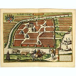
Moscavw. - Moscovia, Urbs, regionis eiusde nominis metropolitia, duplo maior. . .
Town view of the city of Moscow from a slightly elevated viewpoint across the frozen Moskva River. The walled center of the city is depicted with its many churches and fi...
Date: Cologne, 1618
Selling price: ????
Please login to see price!
Sold in 2014
![Sendomiria [with] Biecz](/uploads/cache/35632-250x250.jpg)
Sendomiria [with] Biecz
Bird's-eye views of Sandomierz and Biecz in Poland, each with a key to seven locations. Frans Hogenberg (1535 Mechelen - Cologne 1590) was a copper engraver and etcher. ...
Date: Cologne, 1618
Selling price: ????
Please login to see price!
Sold in 2015
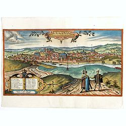
Cracovia Minoris Poloniae Metropolis.
Rare panoramic view of Cracow, only included in volume 6 of "Civitates Orbis Terrarum". This edition without text on verso.The "Civitates Orbis Terrarum&qu...
Date: Cologne, 1618
Selling price: ????
Please login to see price!
Sold in 2020
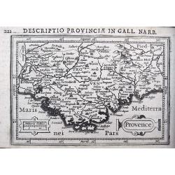
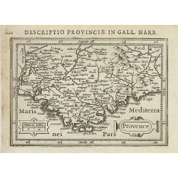
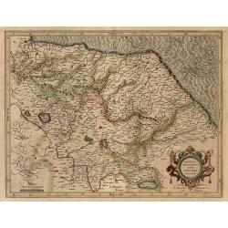
Provence.
A detailed miniature map of the Provence including Nice, Ventimiglia, Cannes, Toulon, Marseille, Orange, Avignon, and many more. Latin text on verso.
Date: Amsterdam, ca 1618
Selling price: ????
Please login to see price!
Sold in 2018
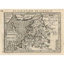
Livoniae Descrip.
Miniature map of the Baltic States Estonia, Latvia & Lithuania.
Date: Amsterdam, 1618
Selling price: ????
Please login to see price!
Sold in 2017
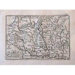
Savoie.
A delightfully small, but very detailed map including the cities of Geneva, Basle, Aosta, Lyon, Valence, and many more.
Date: Amsterdam, ca. 1618
Selling price: ????
Please login to see price!
Sold in 2017
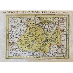
Franciae Comitatus.
A very small but attractive map of the region around Paris, with many details and place names. Latin text on verso.
Date: Amsterdam, ca. 1618
Selling price: ????
Please login to see price!
Sold in 2017
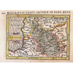
Artesia.
An nice early miniature map of Northern France and the border region of Belgium. From Dieppe to Kortrijk including Lille, Arras, Cambrai. Latin text on verso.
Date: Amsterdam, ca. 1618
Selling price: ????
Please login to see price!
Sold in 2017
Cracovia Metropolis Regni Poloniae.
Rare panoramic view of Cracow only included in volume 6 of "Civitates Orbis Terrarum." This edition is without text on verso.The "Civitates Orbis Terrarum&...
Date: Cologne, 1618
Selling price: ????
Please login to see price!
Sold in 2020
![[Title page] Theatri Geographiae Veteris Tomus prior in quo. . .](/uploads/cache/43982-250x250.jpg)
[Title page] Theatri Geographiae Veteris Tomus prior in quo. . .
This is the lovely title page to Bertius' edition of Ptolemy's 'Geographia' that was copied from Mercator's edition from 1578. The two great Greek geographers stand benea...
Date: Amsterdam, ca 1618
Selling price: ????
Please login to see price!
Sold in 2019
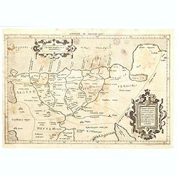
Appendix Tab. III. Africae, Aegyptum Inferiorem Exhibens.
Map of the Nile delta based on the Ptolemaic model. Mercator originally published this map in his 1578 edition of Ptolemy's great Geography. Although he is most renowned ...
Date: Amsterdam, 1618
Selling price: ????
Please login to see price!
Sold in 2020
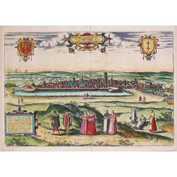
Dantzigt / Gedanum.
A very fine example of this decorative, early view of the town of Danzig. Georg Braun and Franz Hogenberg, published the highly successful "Civitas Orbis Terrarum' i...
Date: Cologne, 1572-1618
Selling price: ????
Please login to see price!
Sold in 2020
![Hagae Comitis celeberrimi totius Evropae municipij typus [The Hague/Den Haag.]](/uploads/cache/84969-250x250.jpg)
Hagae Comitis celeberrimi totius Evropae municipij typus [The Hague/Den Haag.]
A birds-eye-view / town plan of The Hague. - This view comes from the sixth and last volume of the 'Civitates Orbis Terrarum' ("Theatri Praecipuarum Totius Mundi Urb...
Date: Cologne, 1618
Selling price: ????
Please login to see price!
Sold in 2021
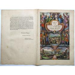
THEATRI PRAECIPUARUM TOTIUS MUNDI URBIUM LIBER SEXTUS, ANNO MDCXVIII.
Title page to volume six of Braun G. & Hogenberg F. 'Civitates Orbis Terrarum'. With the related dedication sheet , dedicated to King Ferdinand of Bohemia.The Civitat...
Date: Cologne, 1618
Selling price: ????
Please login to see price!
Sold in 2021
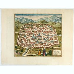
Damascus – Urbs Nobilissima ad Libanum Montem, Totius Syriae Metropolis.
Striking town plan of Damascus shows the fortified walls of the City and various buildings, public squares and other places of interest, with costumed locals and camels i...
Date: Cologne, 1618
Selling price: ????
Please login to see price!
Sold in 2023
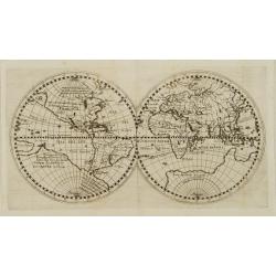
World Map. (No title)
Rare double hemispherical world map showing the track round the world by Le Maire and Schouten in 1615-17. Continents are marked in outline and no southern regions are sh...
Date: Oppenheim, 1618
Selling price: ????
Please login to see price!
Sold in 2009
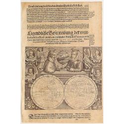
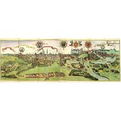
Eigentliche verzeichnus dieses im Jahr 1618.
Although very little is known about Caspar Hersbach, we do know that this broadside celestial chart was made to announce the appearance of a comet in 1618. The comet is i...
Date: Cologne 1618
Selling price: ????
Please login to see price!
Sold
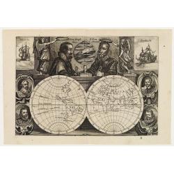
World Map. (No title)
Rare double hemispherical world map showing the track round the world by Le Maire and Schouten in 1615-17. A second state, now including the names of the tropics and the ...
Date: Amsterdam, ca. 1618
Selling price: ????
Please login to see price!
Sold
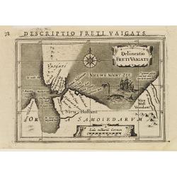
Delineatio Freti Vaigats.
A miniature map of the southern tip of the island of Novaya Zemlya. Discovered by William Barents in 1594. Showing the Vaigach Straits and the surrounding Barents and Kor...
Date: Amsterdam 1618
Selling price: ????
Please login to see price!
Sold
World Map. (No title)
Rare double hemispherical world map showing the track round the world by Le Maire and Schouten in 1615-17. A second state, now including the names of the tropics and the ...
Date: Amsterdam, ca. 1618
Selling price: ????
Please login to see price!
Sold in 2009
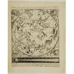
Tabularum Geographicarum Contractarum
Third edition of this rare and influential pocket atlas. All maps are fine and dark impressions. World map engraved by J.Hondius (signed) is appearing twice; celestial ch...
Date: Amsterdam, J.Hondius, 1618
Selling price: ????
Please login to see price!
Sold
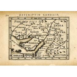
CAMBAIA
Very decorative little map of northern India with Gujarat and the Indus river, bordering Pakistan. Naming major towns represented by symbols, major rivers, mountains, and...
Date: Amsterdam, 1618
Selling price: ????
Please login to see price!
Sold in 2008
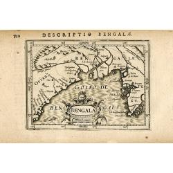
BENGALA
Very decorative little map of the Bay of Bengal, showing parts of India, Bangladesh, and Myanmar (Burma). Presenting major towns with small symbols, also showing major ri...
Date: Amsterdam, 1618
Selling price: ????
Please login to see price!
Sold in 2008
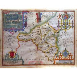
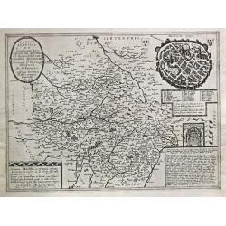
The Countie of Radnor.
A decorative county map from John Speed's atlas, illustrated with a town map of Radnor.
Date: London, 1618
Selling price: ????
Please login to see price!
Sold in 2010
Provence.
Text in Latin on verso.
Date: Amsterdam 1616-1618
Selling price: ????
Please login to see price!
Sold in 2011
Cracovia Metropolis Regni Poloniae.
Rare panoramic view of Cracow, only included in volume 6 of "Civitates Orbis Terrarum". This edition without text on verso.The "Civitates Orbis Terrarum&qu...
Date: Cologne, 1618
Selling price: ????
Please login to see price!
Sold in 2011
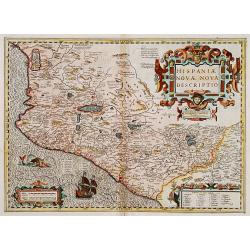
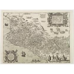
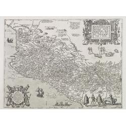
Hispaniae novae nova descriptio.
A map of Mexico, embellished with a large title cartouche, a sailing ship, and a sea monster.
Date: Amsterdam 1619
Selling price: ????
Please login to see price!
Sold
Totius Lemovici.
In 1594 Francois Bougereau published his Le Theatre Francois, the first atlas of France. Jean Leclerc re-issued this atlas in 1619 as 'La Theatre geographique de France. ...
Date: Paris, 1619
Selling price: ????
Please login to see price!
Sold in 2009
No title: Double hemisphere.
This very rare double hemisphere world map is based on the two carefully drawn hemispheres by Hessel Gerritsz..Nicolai has diligently updated Gerritz.' map. There are lin...
Date: Munich 1619
Selling price: ????
Please login to see price!
Sold
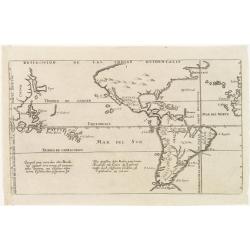
Descripcion de las Indias Ocidentalis.
De Bry's version of this important map by Antonio de Herrera y Tordesillas with cartography based on the manuscript charts of Juan Lopez de Velasco.It depicts the Papal l...
Date: Frankfurt 1619
Selling price: ????
Please login to see price!
Sold
Hispaniae novae sive magnae, recens et vera descriptio * 1595.
This was the standard map of the area for a generation, copied after Ortelius. Both cartouches in the map are copies of designs by Hans Vredeman de Vries. The map shows a...
Date: Frankfurt 1619
Selling price: ????
Please login to see price!
Sold
Zurichgow et Province de Basle (no title).
Gerard Mercator's ' Atlas sive Cosmographica' was published and augmented between 1606 and 1641 by Jodocus Hondius, his son Hendrik and by Johannes Janssonius.A map of th...
Date: Amsterdam, 1619
Selling price: ????
Please login to see price!
Sold
Africa ex magna orbis terre descriptione Gerardi Mercatories desumpta studio & industria G.M. Juniorius
A classic map of Africa. The map first appeared in Gerard Mercator’s Atlas sive Cosmographicae..., published posthumously in 1595. As stated in the title, this map is ...
Date: Duisburg and then Amsterdam, (1595) 1609 or 1619
Selling price: ????
Please login to see price!
Sold in 2011
![[Title page part two] Itinerarium Hierosolymitanum et Syriacum. . .](/uploads/cache/25462-250x250.jpg)
[Title page part two] Itinerarium Hierosolymitanum et Syriacum. . .
Title page with copper engraved view of Jaffa (85x120mm) within letter press, taken from the rare book Itinerarium Hierosolymitanum et Syriacum, in quo variarum Gentium M...
Date: Antwerp, Verdussen, 1619
Selling price: ????
Please login to see price!
Sold in 2009
Varia antiquitates in itinere Bethleëmitico confpecta. . .
Text page with copper engraved illustration of region north of Jerusalem taken from Itinerarium Hierosolymitanum et Syriacum, in quo variarum Gentium Mores et Institua in...
Date: Antwerp, Verdussen, 1619
Selling price: ????
Please login to see price!
Sold in 2009
Hiervsalem.
Text page with copper engraved illustration of Jerusalem, with in background Mount Olive, taken from Itinerarium Hierosolymitanum et Syriacum, in quo variarum Gentium Mor...
Date: Antwerp, Verdussen, 1619
Selling price: ????
Please login to see price!
Sold in 2009
![Hiervsalem. [Jerusalem]](/uploads/cache/25500-250x250.jpg)
Hiervsalem. [Jerusalem]
Text page with copper engraved illustration of Jerusalem, taken from Itinerarium Hierosolymitanum et Syriacum, in quo variarum Gentium Mores et Institua insularum, region...
Date: Antwerp, Verdussen, 1619
Selling price: ????
Please login to see price!
Sold in 2008
Hiervsalem.
Text page with copper engraved plan of Jerusalem, taken from Itinerarium Hierosolymitanum et Syriacum, in quo variarum Gentium Mores et Institua insularum, regionum, vrbi...
Date: Antwerp, Verdussen, 1619
Selling price: ????
Please login to see price!
Sold in 2008
![Ramma. [Ramla] / Domus Boni Latronis [Latrum]](/uploads/cache/25502-250x250.jpg)
Ramma. [Ramla] / Domus Boni Latronis [Latrum]
Text page with copper engraved view of Ramla, taken from Itinerarium Hierosolymitanum et Syriacum, in quo variarum Gentium Mores et Institua insularum, regionum, vrbium s...
Date: Antwerp, Verdussen, 1619
Selling price: ????
Please login to see price!
Sold in 2009
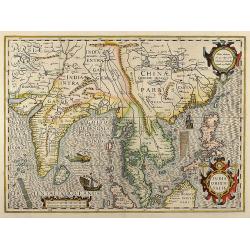
India Orientalis
Beautiful colored map of India, the Malay Peninsula, China and the Philippines, Thailand and Cambodia and parts of Sumatra with Borneo from a French edition of the Mercat...
Date: Amsterdam, 1619
Selling price: ????
Please login to see price!
Sold in 2008
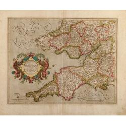
Cornubia, Devonia, Somersetus, Dorcestria, Wiltonia, Glocestria Monumetha, Glamorgan, Caermarden, Penbrok, Cardigan, Radnor, Breknoke, Herefordia, & Wigornia
Original colored map of south west England and south Wales of Gerard Mercator. From a Latin edition of the Mercator Hondius Atlases.
Date: Amsterdam, 1619
Selling price: ????
Please login to see price!
Sold in 2009
Hispaniae novae sive magnae, recens et vera descriptio * 1595.
This was the standard map of the area for a generation, copied after Ortelius. Both cartouches in the map are copies of designs by Hans Vredeman de Vries. The map shows a...
Date: Frankfurt, 1619
Selling price: ????
Please login to see price!
Sold
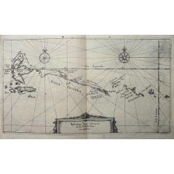
Beschreibung Novae Guineae, wie die von Wilhelm Schouten umbfahren.
Rare and very early map of New Guinea, published in Frankfurt in 1619, as part of Hulsius' Sechtzehende Schiffahrt, which retold the voyage of Willem Schouten. Schouten ...
Date: Frankfurt, 1619
Selling price: ????
Please login to see price!
Sold in 2009
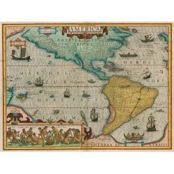
America
Jodocus Hondius's fine delineation of the Americas is probably the most attractive map of the Western Hemisphere in the Mercator/Hondius/Janssonius succession. A clarity ...
Date: Amsterdam, 1619
Selling price: ????
Please login to see price!
Sold in 2010
Africa ex magna orbis terre descriptione Gerardi Mercatories desumpta studio & industria G.M. Juniorius
A classic map of Africa. The map first appeared in Gerard Mercator’s Atlas sive Cosmographicae..., published posthumously in 1595. As stated in the title, this map is b...
Date: Duisburg and then Amsterdam, (1595) 1609 or 1619
Selling price: ????
Please login to see price!
Sold in 2011
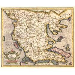
MACEDONIA EPIRUS ET ACHAIA.
Mercator's map of Macedonia.
Date: Amsterdam, 1619
Selling price: ????
Please login to see price!
Sold in 2017
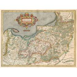
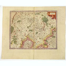
PRUSSIA.
Mercator's map of part of Poland.
Date: Amsterdam, 1619
Selling price: ????
Please login to see price!
Sold in 2014
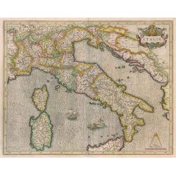
ITALIA
Beautiful map of Italy by G. Mercator.
Date: Amsterdam, 1619
Selling price: ????
Please login to see price!
Sold in 2014
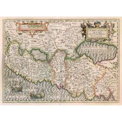
TERRA SANCTA quae in Sacris Terra Promissionis ol: PALESTINA.
Beautiful map of the Holy Land by Hondius.
Date: Amsterdam, 1619
Selling price: ????
Please login to see price!
Sold in 2014
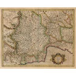
Le Daulphine, Languedoc, Gacoigne, Provence. . .
A highly detailed map of southern France. The title cartouche at the top left hand corner is decorated with bunches of fruit. Rivers, mountain ranges and forests are show...
Date: Paris, 1593 - ca.1619
Selling price: ????
Please login to see price!
Sold in 2017
(World map showing the track round the world by Le Maire and Schouten).
Rare double hemispherical world map showing the track round the world by Le Maire and Schouten in 1615-1617.Continents are marked in outline and no southern regions are s...
Date: Frankfurt, 1619
Selling price: ????
Please login to see price!
Sold in 2016
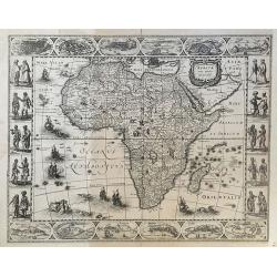
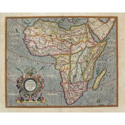
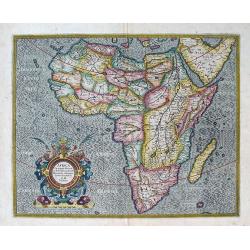
Africae Nova Tabula.
FIRST STATE. This is the very rare, and separately issued, first state of the famous Hondius map. It was hugely influential, providing a milestone for later Africa maps b...
Date: Amsterdam, 1619
Selling price: ????
Please login to see price!
Sold in 2019
Latium nunc Campagna di Roma.
Campagna di Roma.
Date: Amsterdam, 1619
Selling price: ????
Please login to see price!
Sold in 2017
Bavaria Ducatus.
Bayern
Date: Amsterdam, 1619
Selling price: ????
Please login to see price!
Sold in 2016
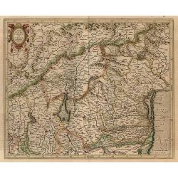
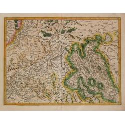
Tarvisina Marchia Et Tirolis Comitatus.
Lombardy and Tyrol. French text on verso.
Date: Amsterdam, 1619
Selling price: ????
Please login to see price!
Sold in 2016
Tuscia.
Toscana. French text on verso.
Date: Amsterdam, 1619
Selling price: ????
Please login to see price!
Sold in 2017
Pedemontana Regio Cum Genuensium Territorio & Montisferrati Marchionatu.
Southwest Lombardy including Piemonte, Monferrato and Liguria. French text on verso.
Date: Amsterdam, 1619
Selling price: ????
Please login to see price!
Sold in 2017
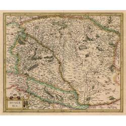
Hungaria.
Hungary. French text on verso.
Date: Amsterdam, 1619
Selling price: ????
Please login to see price!
Sold in 2016
Marchia Anconitana cum Spoletano Ducatus.
Marche. French text on verso.
Date: Amsterdam, 1619
Selling price: ????
Please login to see price!
Sold in 2017
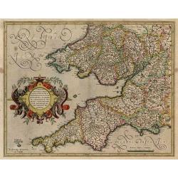
Cornubia, Devonia, Somersetus, Dorcestria, Wiltonia, Glocestria, Monumetha, Glamorgan,..
southwest England and southern Wales. French text on verso.
Date: Amsterdam, 1619
Selling price: ????
Please login to see price!
Sold in 2017
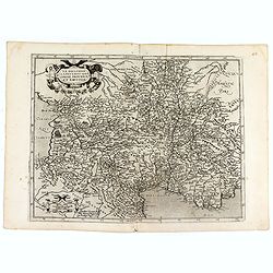
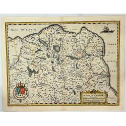
Polonia et Silesia.
Poland. French text on verso.
Date: Amsterdam, 1619
Selling price: ????
Please login to see price!
Sold in 2016
Orbis Terrae Compendiosa Descriptio... ( and) America...(and) Europa ...(and) Africa ... (and) Asia ...
Beautiful set of the world and continents. French text on verso.Orbis Terrae Compendiosa Descriptio Quam ex Magna Universali Gerardi Mercatoris ... Rumoldus Mercator fier...
Date: Amsterdam, 1619
Selling price: ????
Please login to see price!
Sold in 2016
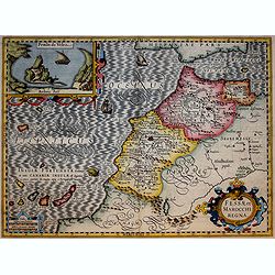
Fessae et Marocchi Regna
Richly embellished map of Morocco with a large inset titled Penon de Velez showing a fort on the Barbary coast. The map includes the Canary islands and Madera.Three strap...
Date: Amsterdam, 1619
Selling price: ????
Please login to see price!
Sold in 2017
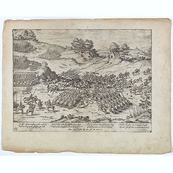
Philippus Strossy Italianischer Captein. . . Plate 26.
Early print from the series about the " Eighty-Years War" or the independence war of Holland against Spain, we know of approximately four hundred engravings by ...
Date: Cologne, ca. 1619
Selling price: ????
Please login to see price!
Sold in 2016
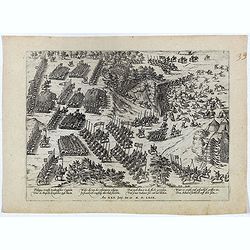
In disser zusammen treffung wirdt es pferdt Des Princen von Conde geschossen zu Erde. . . Plate 64.
Early print showing the killing of the horse of Henri de Bourbon Prince of Condé on 13 March 1619.Plate from the series about the " Eighty Years' War" or the i...
Date: Cologne, ca. 1619
Selling price: ????
Please login to see price!
Sold in 2021
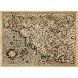
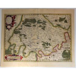
Abruzzo et Terra de Lavoro.
A striking map of Abruzzo in Northern Napoli and the neighbouring regions, from an early edition of the Mercator-Hondius Italia Sclavonia et Greciae Tabula Geographicae. ...
Date: Amsterdam, 1619
Selling price: ????
Please login to see price!
Sold in 2017
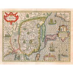
China.
Important map of China. Besides China, the map depicts Korea as an elongated island and Japan from the Teixeira model of 1595
Date: Amsterdam, 1619
Selling price: ????
Please login to see price!
Sold in 2017
Bolonia & Guines Comitatus.
A fine Hondius map showing a part of northwestern France. The map is oriented with west at the top and shows the French coast from Calais to Grofflieres and the Canche Ri...
Date: Amsterdam, 1619
Selling price: ????
Please login to see price!
Sold in 2020
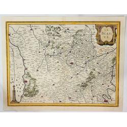
La Beauce.
A fine Hondius map of 'La Beauce' (Northern France between Seine and Loire rivers). This maps shows the cities of: Chartres, Orleans, Blois, Paris and others, and it fea...
Date: Amsterdam, 1619
Selling price: ????
Please login to see price!
Sold in 2023
L'Isle de France Parisiesis Agri de Scriptio Auctore.
A detailed map of the region with Paris and Vincennes. It is beautifully engraved with forests, cities, villages and rivers with the compounds at Vincennes and Madril pro...
Date: Amsterdam, 1619
Selling price: ????
Please login to see price!
Sold in 2018
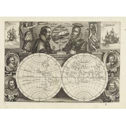
![[No Title] Gerardus Mercator natus rupelmundae III . . .](/uploads/cache/42981-250x250.jpg)
[No Title] Gerardus Mercator natus rupelmundae III . . .
The double portraits of two of the greatest men in cartography, Gerard Mercator of Rupelmund and Judocus Hondius of Flandria. A superb example of the engravers skill of C...
Date: Amsterdam, 1619
Selling price: ????
Please login to see price!
Sold in 2019
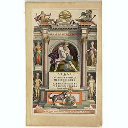
Atlas sive Cosmographicae Meditationes . . . (Title page)
Architectural frontage with personifications of the four Continents, Atlas, Peruana and Magalanica. This is the updated version with the lower text panel stippled and ove...
Date: Amsterdam, 1619
Selling price: ????
Please login to see price!
Sold in 2019
![[Title page] Belgii Inferioris Geographicae Tabulae.](/uploads/cache/43981-250x250.jpg)
[Title page] Belgii Inferioris Geographicae Tabulae.
A lovely frontispiece in the Dutch Renaissance style with the title surrounded with strapwork designs, garlands, fruit, fish and cherubs. From the Atlas sive Cosmographie...
Date: Amsterdam, ca 1619
Selling price: ????
Please login to see price!
Sold in 2020
![[Untitled map of Southern Scotland].](/uploads/cache/44629-250x250.jpg)
[Untitled map of Southern Scotland].
An attractive early seventeenth century map of southern Scotland by Hondius. Some of the Inner & Outer Hebridean Isles are shown Skye, Mull, Arran, Mull, Egge, Islay,...
Date: Amsterdam, ca 1619
Selling price: ????
Please login to see price!
Sold in 2019
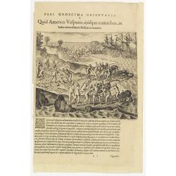
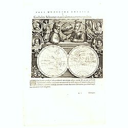
Pars Undecima Orientalis I. Quid Americo Vesputio, ejusque comitibus, in India . . .
Amerigo Vespucci (1454-1512) or one of his crew members capturing by female cannibals at arrival in South America. Note the violin which is oddly included among the strew...
Date: Frankfurt, 1619
Selling price: ????
Please login to see price!
Sold in 2023
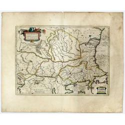
WALACHIA, SERVIA, BULGARIA, ROMANIA.
A decorative, striking example of Blaeu's map of the Lower Danube, Bulgaria, Romania, Serbia and Macedonia.
Date: Amsterdam, 1619
Selling price: ????
Please login to see price!
Sold in 2020
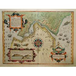
Exquisita & magno aliquot.. Freti Magellanici. . .
A map of the extremities of South America. North at 180 degrees. Borders graduated for latitude. Single compass rose with radiates. Scale in German miles. Soundings and s...
Date: Amsterdam, 1619
Selling price: ????
Please login to see price!
Sold in 2020
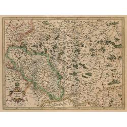
Palatinatus RhenI.
A nice, detailed map of the Rheinpfalz in Germany by Mercator, an early and famous map publisher.An attractive map, covering part of the river Rhine, that includes (among...
Date: Amsterdam, ca 1619
Selling price: ????
Please login to see price!
Sold in 2021
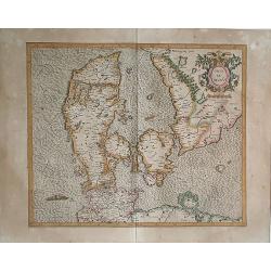
Daniae Regnu.
A map of Denmark, with a sea monster in the sea. Mercator was born in Rupelmonde in Flanders and studied in Louvain under Gemma Frisius, Dutch writer, astronomer and math...
Date: Amsterdam, 1619
Selling price: ????
Please login to see price!
Sold in 2020