Browse Listings
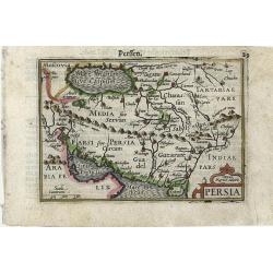
Persia
Very fine early miniature map of Persia, this map is from the first edition of the Langenes atlas, (later well known under the name of Bertius). Dutch text on verso.
Date: Middelburg, 1598
Selling price: ????
Please login to see price!
Sold in 2010
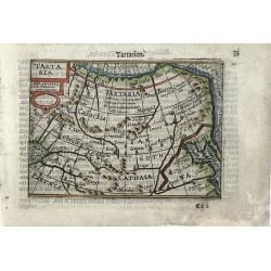
Tartaria
Very fine early miniature map of Tartaria with the wall on the map, this map is from the first edition of the Langenes atlas, (later well known under the name of Bertius)...
Date: Middelburg, 1598
Selling price: ????
Please login to see price!
Sold in 2010
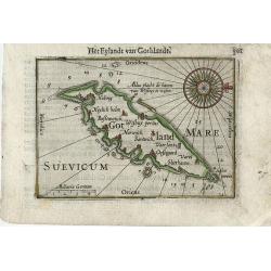
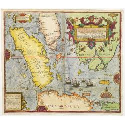
Gotland
Very fine early miniature map of Gotland, this map is from the first edition of the Langenes atlas, (later well known under the name of Bertius). Dutch text on verso.
Date: Middelburg, 1598
Selling price: ????
Please login to see price!
Sold in 2010
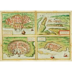
CALARIS, MALTA, RHODUS, FAMAGUSTA.
Four separate views of historical Mediterranean islands on one sheet. Malta, Calaris, Rhodes ( Rhodus ), Famagusta.From the greatest publication in this genre! The Civita...
Date: Cologne 1598
Selling price: ????
Please login to see price!
Sold
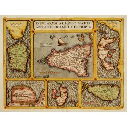
Insularum Aliquot Maris Mediterranei Descriptio.
Six maps on one sheet. In the center a map of Sicily, surrounded by maps of Sardinia, Djerba, The island of Elbe, Corfu and Malta.
Date: Antwerp 1598
Selling price: ????
Please login to see price!
Sold
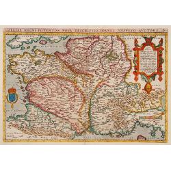
Galliae Regni Potentiss: Nova Descriptio Ioanne Ioliveto Auctore.
A decorative view of 16th Century France that is derived from Jean Jolivet's woodcut map of 1560. Decorated with one large cartouche and one smaller royal crest. The map ...
Date: Antwerp, 1598
Selling price: ????
Please login to see price!
Sold
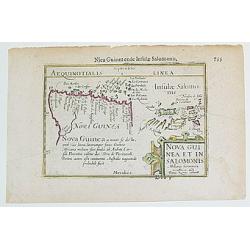
Nova Guinea et In. Salomonis.
From the CAERT-THRESOOR, one the very first maps to depict New Guinea as a separate island. This work is also the first to provide a "full" charting / identific...
Date: Paris, 1598
Selling price: ????
Please login to see price!
Sold
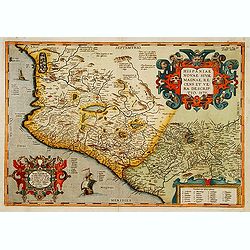
Hispaniae Novae sive magnae,..
This was the standard map of the area for a generation, copied by De Bry, Quad and Hondius. Even though Herrera (Spain's Royal Cosmographer) and Wytfliet worked 20 years ...
Date: Antwerp, 1598
Selling price: ????
Please login to see price!
Sold
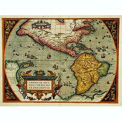
Americae Sive Novi Orbis, Nova Descriptio
Woodcut map by based on Abraham Ortelius' classic map of 1570, with the huge bulge in the southwest coastline of South America, the Ortelian western coastline of North Am...
Date: Basel 1598
Selling price: ????
Please login to see price!
Sold
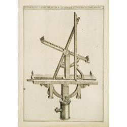
Instrument geometrique dict la barque..
Early copper engraving by Amboise Bachot. He was the author of Le gouvernail lequel conduira le curieux de geometrie en perspective dedans l'architecture des fortificatio...
Date: Paris 1598
Selling price: ????
Please login to see price!
Sold

Barque de rassembler plusieurs termes pour parvenir..
Early copper engraving by Amboise Bachot. He was the author of Le gouvernail lequel conduira le curieux de geometrie en perspective dedans l'architecture des fortificatio...
Date: Paris 1598
Selling price: ????
Please login to see price!
Sold
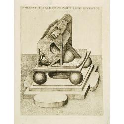
Ambrosius Bachotus Parisiensis Inventor.
Early copper engraving by Amboise Bachot. He was the author of Le gouvernail lequel conduira le curieux de geometrie en perspective dedans l'architecture des fortificatio...
Date: Paris 1598
Selling price: ????
Please login to see price!
Sold
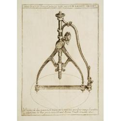
Compas Geometrique descrivant.. proposée P.AB Bachot.
Early copper engraving by Amboise Bachot. He was the author of Le gouvernail lequel conduira le curieux de geometrie en perspective dedans l'architecture des fortificatio...
Date: 1598
Selling price: ????
Please login to see price!
Sold
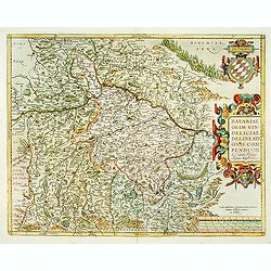
Bavariae, olim vindeliciae delineationis..
Fine and early map of Bavaria, prepared by Philipp Apian in 1561 and used by Ortelius in his atlas 'Theatrum Orbis Terrarum [Atlas of the Whole World]. The Theatrum was r...
Date: Anvers, 1598
Selling price: ????
Please login to see price!
Sold
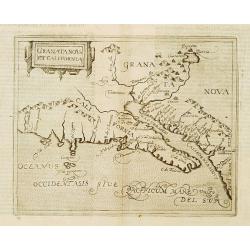
Granata Nova et California.
Very rare sixteenth century map: the second printed map devoted to the California peninsula and the south west of present day United States. A reduced version of the Corn...
Date: Cologne 1598
Selling price: ????
Please login to see price!
Sold
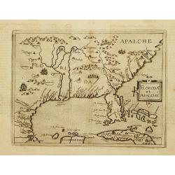
Florida et Apalche.
Very rare sixteenth century map: drawn from the Abraham Ortelius -Gerónimo de Chaves map entitled La Florida, published in 1584. However, here Metellus expands the area ...
Date: Cologne 1598
Selling price: ????
Please login to see price!
Sold
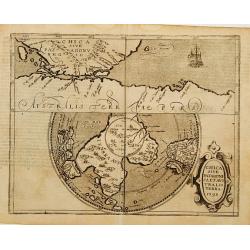
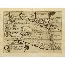
Chica sive Patagonica et Australis Terra 1598.
Very rare sixteenth century map: A reduced version of the Cornelis Wytfliet map of the same name.The map is divided into two sections. The top half is drawn on normal pro...
Date: Cologne 1598
Selling price: ????
Please login to see price!
Sold
Maris Pacifici vulgo Mar del Zur.
The second printed map devoted to the Pacific.Published in the German edition of José de Acosta's De Natura Nova Orbis. All other maps in the book are reduced versions o...
Date: Cologne 1598
Selling price: ????
Please login to see price!
Sold
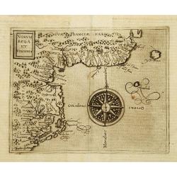
Norumbega et Virginia.
Rare sixteenth century map: It shows the east coast of North America from the Outer Banks of present day Carolina to Canada is depicted at a period just before a number o...
Date: Cologne 1598
Selling price: ????
Please login to see price!
Sold
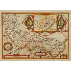
Agri Cremonensis Typvs.
Region in the Northern portion of Italy with the city of Cremonia near the center. With very decorative inset map of Crema, copied after Forlani's map of 1570. First publ...
Date: Antwerp 1598
Selling price: ????
Please login to see price!
Sold
Oost ende West Vrieslandte beschryvinghe.
Prepared by Jacob van Deventer. A very decorative map of the Dutch provinces of Friesland, Groningen and Drente and of the German Province of Friesland.
Date: Antwerp 1598
Selling price: ????
Please login to see price!
Sold
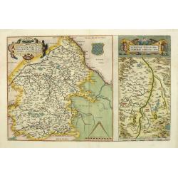
Regionis Biturigum... Per Ioannem Calamaeum. / Limaniae Topographia Gabriele Symeoneo Auct.
Two maps on one sheet.
Date: Antwerp 1598
Selling price: ????
Please login to see price!
Sold in 2009
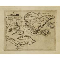
Estotilandia et Laboratoris terra.
This is an important and influential map depicting the first detailed record of the discoveries of Davis and Frobisher in their search for the Northwest Passage. The attr...
Date: Cologne 1598
Selling price: ????
Please login to see price!
Sold
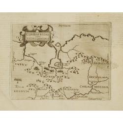
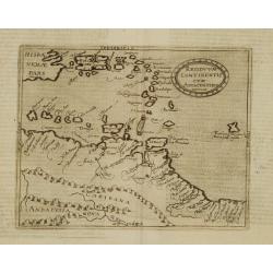
Conibas regio cum vicinis gentibus.
This is, however, the first printed map of present-day central Canada. The basic cartography derives from Gerard Mercator's world map of 1569, which first depicted a larg...
Date: Cologne 1598
Selling price: ????
Please login to see price!
Sold
Limes occidentis et quiuira Anian.
Very rare sixteenth century map: One of the first printed map to focus on present day Alaska, here labeled "Anian Regnum." It encompasses most of the western co...
Date: Cologne 1598
Selling price: ????
Please login to see price!
Sold
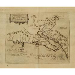
Granata Nova et California.
Very rare sixteenth century map: the second printed map devoted to the California peninsula and the south west of present day United States. A reduced version of the Corn...
Date: Cologne 1598
Selling price: ????
Please login to see price!
Sold
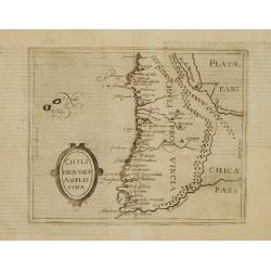
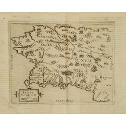
Chili Provincia Amplissima.
Very rare sixteenth century map of Chili.Published in the German edition of José de Acosta's De Natura Nova Orbis, first published in Salamanca, 1588. Acosta was a Spani...
Date: Cologne 1598
Selling price: ????
Please login to see price!
Sold
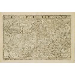
Typus orbis terrarum.
Very rare sixteenth century world map in Mercator projection.Published in the German edition of José de Acosta's De Natura Nova Orbis, first published in Salamanca, 1588...
Date: Cologne 1598
Selling price: ????
Please login to see price!
Sold
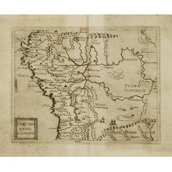
Peruani Regni Discriptio.
Very rare sixteenth century map of Peru.Published in the German edition of José de Acosta's De Natura Nova Orbis, first published in Salamanca, 1588. Acosta was a Spanis...
Date: Cologne 1598
Selling price: ????
Please login to see price!
Sold
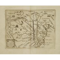
Plata Americae Provincia.
Very rare sixteenth century map showing part of Peru and the territory known as Paraguay including La Plata River and south part of Brazil, with effluents of Panama river...
Date: Cologne 1598
Selling price: ????
Please login to see price!
Sold
Residuum Continentis cum Adiacentibus Insulis.
Very rare sixteenth century map of Venezuela, including the islands of Curaçao, Bonaire, Aruba and the islands in the Caribbean and Puerto Rico.Published in the German e...
Date: Cologne 1598
Selling price: ????
Please login to see price!
Sold
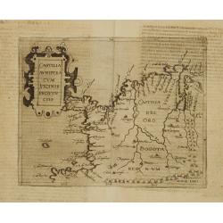
Castilia Aurifera cum vicinis Provinciis.
Very rare sixteenth century map of Colombia.Published in the German edition of José de Acosta's De Natura Nova Orbis, first published in Salamanca, 1588. Acosta was a Sp...
Date: Cologne 1598
Selling price: ????
Please login to see price!
Sold
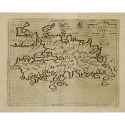
Hispaniola Insula.
Very rare sixteenth century map of the Hispaniola Island and the eastern tip of Cuba.Published in the German edition of José de Acosta's De Natura Nova Orbis, first publ...
Date: Cologne 1598
Selling price: ????
Please login to see price!
Sold
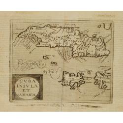
Cuba Insula et Iamaica.
Very rare sixteenth century map of Cuba, in lower part JamaicaPublished in the German edition of José de Acosta's De Natura Nova Orbis, first published in Salamanca, 158...
Date: Cologne 1598
Selling price: ????
Please login to see price!
Sold
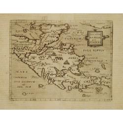
Iucatana Regio et Fondura.
Very rare sixteenth century map of Yucatan and Honduras.Published in the German edition of José de Acosta's De Natura Nova Orbis, first published in Salamanca, 1588. Aco...
Date: Cologne 1598
Selling price: ????
Please login to see price!
Sold
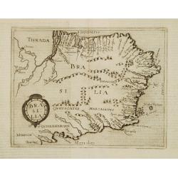
Brasilia.
Very rare sixteenth century map of Brazil.Published in the German edition of José de Acosta's De Natura Nova Orbis, first published in Salamanca, 1588. Acosta was a Span...
Date: Cologne 1598
Selling price: ????
Please login to see price!
Sold
Americae Sive Novi Orbis, Nova Descriptio.
In 1587, a new plate was engraved which appeared in editions from 1588 onwards. Of the three maps, this one is perhaps the most important. Geographically, it is the most ...
Date: Antwerp, 1598
Selling price: ????
Please login to see price!
Sold

Two title pages to a book:
by Dionysii Gothefridii I.C. (part 1 and 2). Printed in 1598 by W.Lemarie. Renaissance borders on 4 sides
Date: 1598
Selling price: ????
Please login to see price!
Sold
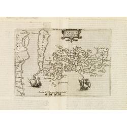
Iaponia regnum.
One of the earliest printed map of Japan and the first copy after Ortelius / Teixeira.Published in the German edition of José de Acosta's De Natura Nova Orbis, first pub...
Date: Cologne c. 1598
Selling price: ????
Please login to see price!
Sold
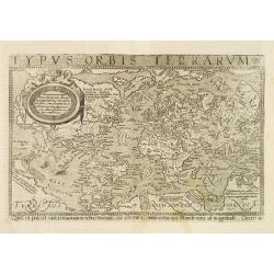
Typus orbis terrarum.
Very rare sixteenth century world map in Mercator projection.Published in the German edition of José de Acosta's De Natura Nova Orbis, first published in Salamanca, 1588...
Date: Cologne 1598
Selling price: ????
Please login to see price!
Sold
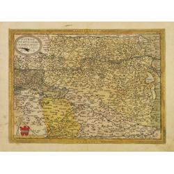
Austriae ducatvs chorographia, Wolfgango Lazio auctore.
Fine and early map of Austria after Wolfgang Lazius and used by A.Ortelius in his atlas Theatrum Orbis Terrarum [Atlas of the Whole World].Only included in the atlas edit...
Date: Antwerp 1598
Selling price: ????
Please login to see price!
Sold in 2009
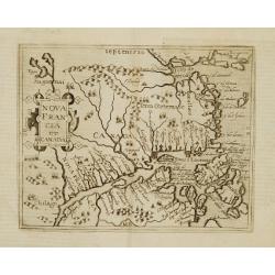
Nova Francia et Canada.
Very rare sixteenth century map: the second printed map to use CANADA in its title, and the second to concentrate on the river and Gulf of St.Lawrence. It summarises sixt...
Date: Cologne 1598
Selling price: ????
Please login to see price!
Sold
Nova tabula Insularum Javae, Sumatrae, Borneonis..
A most important foundation map, one of the first detailed European maps to focus on southern Malaysia and the region around present-day Singapore. The map was published ...
Date: Frankfurt 1598
Selling price: ????
Please login to see price!
Sold
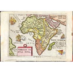
Africae Tabula Nova
From the Ortelius miniature atlas 'Epitome theatri Orteliani' published by Philip Galle. Colored in nice, period correct color. Printers crease running through West Afric...
Date: Antwerp, ca 1598
Selling price: ????
Please login to see price!
Sold

(Title page) Urbium Praecipuarum Mundi Theatrum Quintum
The most decorative frontispiece of the 5th part of the 'Civitatus Orbis Terrarum'. Showing heraldic figures, representations of the four continents and 5 European and on...
Date: Amsterdam 1598
Selling price: ????
Please login to see price!
Sold
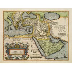
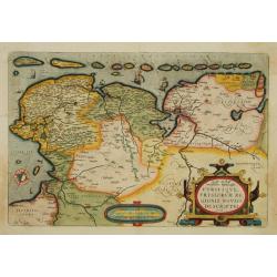
Turcici Imperii Descriptio.
This is the best known of all the sixteenth-century maps of the Ottoman Empire, which at the time of publication encompassed the present nations of Egypt, Israel, Lebanon...
Date: Antwerp, 1598
Selling price: ????
Please login to see price!
Sold in 2008
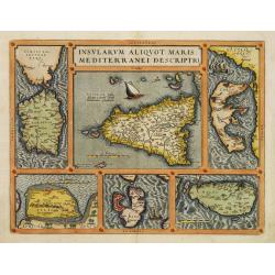
Insularum Aliquot Maris Mediterranei Descriptio.
Six maps on one sheet. In the center a map of Sicily, surrounded by maps of Sardinia, Djerba, The island of Elbe, Corfu and Malta.
Date: Antwerp 1598
Selling price: ????
Please login to see price!
Sold
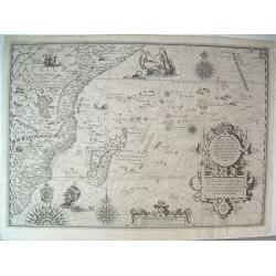
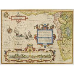
Affbeeldinghe der custen des landts...Terra do Natal.
A superbly decorative early chart engraved by Arnold van Langren showing the African coastline of the Indian Ocean from the Cape to Natal, Mozambique and Madagascar. From...
Date: Amsterdam 1598
Selling price: ????
Please login to see price!
Sold
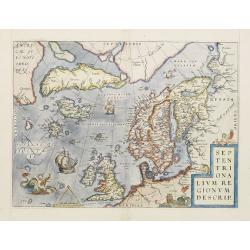
Septentrionalium Regionum Descrip.
This influential map of the Arctic, including Scandinavia, Iceland, Greenland and part of the North American continent, includes also the legendary islands of i.a. Drogeo...
Date: Antwerp 1598
Selling price: ????
Please login to see price!
Sold
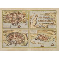
MALTA, CALARIS, RHODES, FAMAGUSTA.
Four separate views of historical Mediterranean islands on one sheet. MALTA, CALARIS, RHODES ( Rhodus ), FAMAGUSTA.From the greatest publication in this genre!. The Civit...
Date: Cologne, 1598
Selling price: ????
Please login to see price!
Sold in 2008
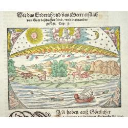
Das erste buch der cosmography
This interesting woodcut illustrates the creation as described in Genesis. It is printed on a full sheet of German text featuring a large decorative initial
Date: Basle 1598
Selling price: ????
Please login to see price!
Sold
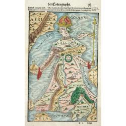
Europa Regina
This is one of the most famous of cartographic oddities showing Europe in the shape of a woman. The representation of Europa Regina or Queen of Europe, was first drawn by...
Date: Basel 1598
Selling price: ????
Please login to see price!
Sold
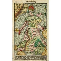
Europa Regina
This is one of the most famous of cartographic oddities showing Europe in the shape of a woman. The representation of Europa Regina or Queen of Europe, was first drawn by...
Date: Basel 1598
Selling price: ????
Please login to see price!
Sold
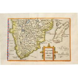
Regnum Monomotapae.
Metellus Rare Map of Southern Africa, from a 1598 Latin edition of Botero's "Theatrum Principum Orbis Universi". Modelled on the southern section of Mercator's ...
Date: Cologne, 1598
Selling price: ????
Please login to see price!
Sold in 2008
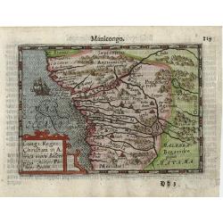
Affbeeldinghe der custen des landts Guinea, Manicongo..
A superbly decorative early engraved by Arnold Van Langren. The ocean is filled with superbly engraved compass spurs, Dutch galleons and elaborate strapwork cartouches. ...
Date: Amsterdam, 1598
Selling price: ????
Please login to see price!
Sold in 2008
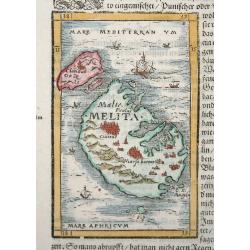
Melita.
This tiny map, set into a sheet of text, is one of the earliest available maps of the strategically important Mediterranean islands of Malta and Gozo. The woodblock map s...
Date: Basle, 1598
Selling price: ????
Please login to see price!
Sold in 2009
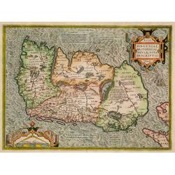
Hiberniae Britannicae insulae nova descriptio.
Copied from Mercator's influential wall map of the British Isles of 1564, this is certainly the best map of Ireland of the 16th century.
Date: Antwerp, 1598
Selling price: ????
Please login to see price!
Sold in 2009
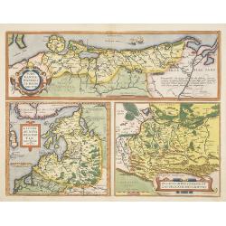
Pomeraniae, Wandalicae Regionis, Typ. - Livoniae Nova Descriptio, Ioanne Portantio auctore. - Ducatus Oswieczensis, et Zatoriensis, Descriptio.
Three maps on one sheet. The first map covers northern part of Pomerania. The map of Livonia is prepared by Johannes Portanius, who was a contemporary of Ortelius who als...
Date: Antwerp, 1598
Selling price: ????
Please login to see price!
Sold in 2009
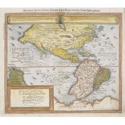
Americae Sive Novi Orbis, Nova Descriptio.
Woodcut map by based on Abraham Ortelius' classic map of 1570, with the huge bulge in the southwest coastline of South America, the Ortelian western coastline of North Am...
Date: Basel 1598
Selling price: ????
Please login to see price!
Sold in 2010
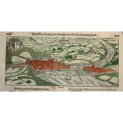
.. Stett Genff.. (Geneva)
An uncommon and early woodblock view of Geneva as a medieval walled city on the shores of Lake Leman. The skyline is dominated by the Cathedral of St. Peter, where John C...
Date: Basle 1598
Selling price: ????
Please login to see price!
Sold in 2009
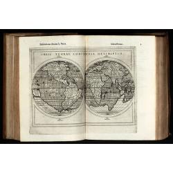
Geografia di Claudio Tolomeo Alessandrino Tradotta di Greco nell'Idioma Volgare Italiano da Girolamo Ruscelli
Sixth edition of Ruscelli's translation of Ptolemy's Geografia edited and extended by Giuseppe Rosaccio published by the Hires of M. Sessa in 1598 and 1599.Illustrated wi...
Date: Venice, 1598
Selling price: ????
Please login to see price!
Sold in 2010
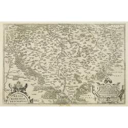
Regni Bohemiae descriptio.
Fine and early map of Czechoslovakia after Johann Criginger and used by A.Ortelius in his atlas 'Theatrum Orbis Terrarum [Atlas of the Whole World].Only included in the a...
Date: Antwerp, 1598
Selling price: ????
Please login to see price!
Sold in 2010
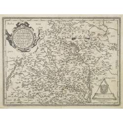
Moraviae, quae olim Marcomannorum Sedes, Corographia, A.D. Pavlo Fabritio Medico et Mathematico Descripta. . .
Copper engraving, uncolored as published. Fine and decorative early map of Moravia, Slovakia prepared by Paul Fabritius (1569) and revised by Crato.The map provides good ...
Date: Antwerp, 1598
Selling price: ????
Please login to see price!
Sold in 2010
Pomeraniae, Wandalicae Regionis, Typ. - Livoniae Nova Descriptio, Ioanne Portantio auctore. - Ducatus Oswieczensis, et Zatoriensis, Descriptio.
Three maps on one sheet. The first map covers northern part of Pomerania. The map of Livonia is prepared by Johannes Portanius, who was a contemporary of Ortelius who als...
Date: Antwerp, 1598
Selling price: ????
Please login to see price!
Sold in 2010
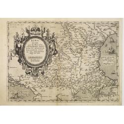
Romaniae, (quae olim Thracia dicta) ..
An early impression, without text on verso. Very fine map centered on the Danube area. The map is based on the double sheet map by Jacob Gastaldi. Abraham Ortelius (1527-...
Date: Antwerp, before 1598
Selling price: ????
Please login to see price!
Sold in 2010
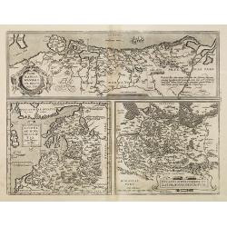
Carpetaniae Partis Desc.1584. -Guipus Coae Regionis Typus.
An ornate and highly decorative set of three maps on one sheet, Carpetanin, (upper left), Guipuzcoa, (upper right) and Cadiz (lower center). The maps are highly decorativ...
Date: Antwerp, 1598
Selling price: ????
Please login to see price!
Sold in 2010
Congi Regni Christiani in Africa.
A fine early miniature map of the West coast of Africa, this map is from the first edition of the Langenes atlas (later well known under the name of Bertius). Dutch text ...
Date: Middelburg, 1598
Selling price: ????
Please login to see price!
Sold in 2014
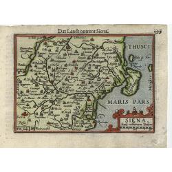
Siena.
A fine early miniature map of Siena, this map is from the first edition of the Langenes atlas (later well known under the name of Bertius). Dutch text on verso.
Date: Middelburg, 1598
Selling price: ????
Please login to see price!
Sold in 2014
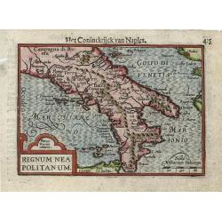
Regnum Neapolitanum.
Very fine early miniature map of the Southern part of Italy, this map is from the first edition of the Langenes atlas, (later well known under the name of Bertius). Dutch...
Date: Middelburg, 1598
Selling price: ????
Please login to see price!
Sold in 2010
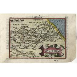
Aprutium
Very fine early miniature map of a part of Italy, this map is from the first edition of the Langenes atlas, (later well known under the name of Bertius). Dutch text on ve...
Date: Middelburg, 1598
Selling price: ????
Please login to see price!
Sold in 2014
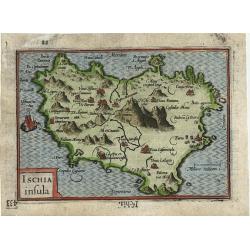
Ischia insula
Very fine early miniature map of a part of Italy, this map is from the first edition of the Langenes atlas, (later well known under the name of Bertius). Dutch text on ve...
Date: Middelburg, 1598
Selling price: ????
Please login to see price!
Sold in 2010
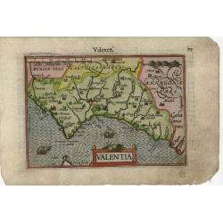
Valentia
Excellent early miniature map of a part of Spain; this map is from the first edition of the Langenes atlas (later well known under the name of Bertius). Dutch text on ver...
Date: Middelburg, 1598
Selling price: ????
Please login to see price!
Sold in 2010
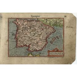
Hispania
Excellent early miniature map of a part of Spain; this map is from the first edition of the Langenes atlas (later well known under the name of Bertius). Dutch text on ver...
Date: Middelburg, 1598
Selling price: ????
Please login to see price!
Sold in 2010
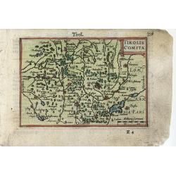
Tirolis Comita
Excellent early miniature map of a part of Austria; this map is from the first edition of the Langenes atlas (later well known under the name of Bertius). Dutch text on v...
Date: Middelburg, 1598
Selling price: ????
Please login to see price!
Sold in 2014
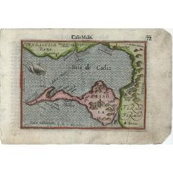
Calis Malis
Very fine early miniature map of a part of the Bay of Cadiz, this map is from the first edition of the Langenes atlas, (later well known under the name of Bertius). Dutch...
Date: Middelburg, 1598
Selling price: ????
Please login to see price!
Sold in 2012

Carthaginensis sinus.
Very fine early miniature map showing Tunis and its surroundings. The sea is embellished with a ship and a sea monster. The map depicts the ancient site of Carthage with ...
Date: Middelburg, 1598
Selling price: ????
Please login to see price!
Sold in 2014
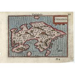
Cefalonia
Very fine early miniature map of the Greek island of Cefalonia (Cephalonia), this map is from the first edition of the Langenes atlas, (later well known under the name of...
Date: Middelburg, 1598
Selling price: ????
Please login to see price!
Sold in 2010
Filippo Pigafetta-De Bry Map of Africa.
This is the De Bry version of the Pigafetta map of Africa. It is a close copy of the Pigafetta map. Pigafetta wrote a book entitled Relatione del reame di Congo et del...
Date: Frankfurt, 1598
Selling price: ????
Please login to see price!
Sold in 2010
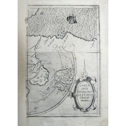
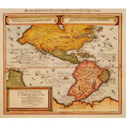
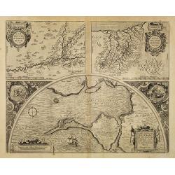
Chica Sive Patagonica et Australis Terra.
Fragment of the famous and rare copper engraved map by Cornelius Wytfliet, published in "Descriptionis Ptolemaicae Augmentum". The map portion on the top shows...
Date: 1598
Selling price: ????
Please login to see price!
Sold in 2011
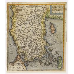
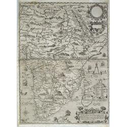
Natoliae quae olim Asia minor.
East to the top. Detailed map Turkey, including Cyprus and Crete. German text on verso.
Date: Antwerp, 1598
Selling price: ????
Please login to see price!
Sold in 2010