Browse Listings
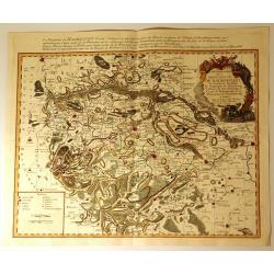
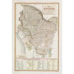
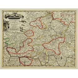
Carte Particuliere de la Principaute de Halberstadt
Carte Particuliere de la Principaute de Halberstadt. A large and rare map of Halberstadt, Germany, and its surroundings by Le Rouge. Showing the town in the German state...
Date: Paris, 17576
Selling price: ????
Please login to see price!
Sold in 2015
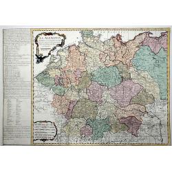
La ALEMANIA dividida en sus principales Estados segun las ultimas y nuevas observationes de las Accademias y de Paris y de Londres.
A beautiful, rare colored map of Germany by the Spanish cartographer Pedro Gendron. As in most 18th century maps published in Spain, which are based upon non-Spanish sour...
Date: Madrid(?), ca 1760
Selling price: ????
Please login to see price!
Sold in 2020
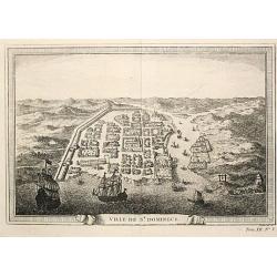
Ville de St. Domingue.
An attractive view of the town of St. Domingue.
Date: Paris, c. 1760.
Selling price: ????
Please login to see price!
Sold
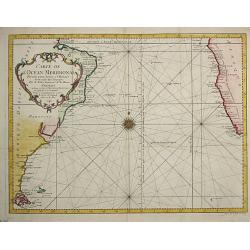
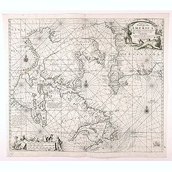
Carte de l Ocean Meridional, 1746.
Jaques Nicolas Bellin (1702-720) was the most important French hydrographer of the 18th century. Sea-atlas 'Hydrographique Français', 1756-65, atlas to accompany Prévos...
Date: Amsterdam, c. 1760.
Selling price: ????
Please login to see price!
Sold
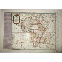
CARTE NOUVELLE D'AFRIQUE.
An original rare copper engraved map of 'modern' Africa by Moithey, published by Etienne André Philippe de Pretot, Paris, from the atlas 'Cosmographie Universelle' - ca ...
Date: Paris ca 1765
Selling price: ????
Please login to see price!
Sold in 2021
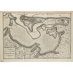
De Hoofdstad en Haven van 't Eiland Porto Rico in de Westindien.
Izaak Tirion (d. 1769) Amsterdam publisher. His 'Nieuwe en beknopte handatlas' saw 6 editions between before 1740 and after 1784. Also 'Tegenwoordige staat van alle volke...
Date: Amsterdam, 1765.
Selling price: ????
Please login to see price!
Sold
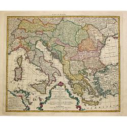
Totius Danubii cum Adjacentibus Regnis nec non totius Graciae et Archipelagi.
Homann Heirs (of Johann Baptist and Johann Christof) published: Grosser Atlas, 1731, 1737. Geogr. Maior, 1759, Atlas Homannianus, 1762.A map depicting southeast Europe wi...
Date: Nurnberg, 1766.
Selling price: ????
Please login to see price!
Sold
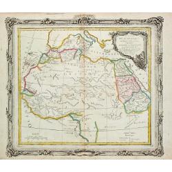
Partie de L' Afrique en deca de l' Equateur.
Louis Brion de la Tour (1756-1823), ' Atlas Géneral, Civil et Ecclésiastique', 1766, ' Atlas Général', 1790-98. Louis Charles Desnos (fl.1750-70), Le Rouge's 'Atlas N...
Date: Paris, 1766.
Selling price: ????
Please login to see price!
Sold
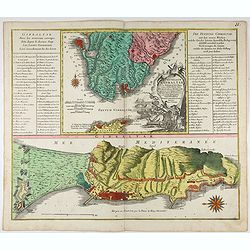
Castellum Gibraltar in Andalusia..
Two maps of Gibraltar on one sheet: a plan of the Rock up to the Spanish lines: and a chart of the Straits, also showing Cadiz and Marbella. The title cartouche shows the...
Date: Augsburg, c.1770.
Selling price: ????
Please login to see price!
Sold in 2021
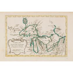
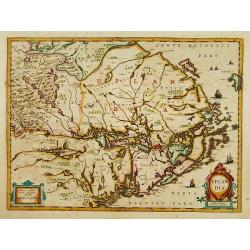
Carte des Lacs du Canada..
Scarce edition of this accurate map showing the all the Great Lakes in the traditional Bellin configuration.Kershaw does not mention this state with in lower right corner...
Date: Amsterdam, 1773.
Selling price: ????
Please login to see price!
Sold in 2014
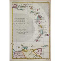
Carte des Isles Antilles ou du Vent avec la Partie orientale des Isles sous le Vent.
Rigobert Bonne (1727-1795), French cartographer. His maps are found in a.o. Atlas Moderne (1762), Raynal's Histoire Philos. du Commerce des Indes (1774) and Atlas Encyclo...
Date: Paris, 1774.
Selling price: ????
Please login to see price!
Sold
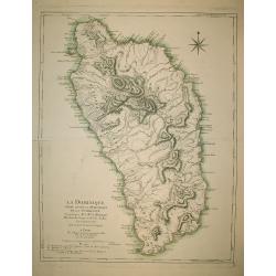
La Dominique située entre La Martinique et La Guadeloupe
A map of Dominica by Le Rouge.
Date: Paris, s.d. (1778)
Selling price: ????
Please login to see price!
Sold in 2009
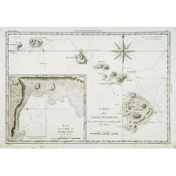
Carte des Isles Sandwich.
Handsome copper-engraved chart of the archipelago of Hawaii with a large inset "Plan de la Baye de Karakakooa." Cook's tracks through the island chain in both 1...
Date: Paris 1779.
Selling price: ????
Please login to see price!
Sold
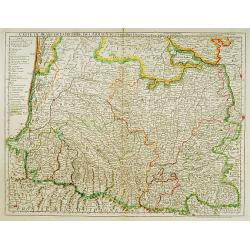
Carte du Bearn de la Bigorre de l'Armagnac..
Map of south-west part of France covering the Landes country with Dax, Bayonne and Pau till Montauban and Toulouse on the right.
Date: Paris [c. 1780]
Selling price: ????
Please login to see price!
Sold
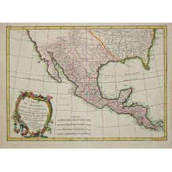
Carte du Mexique ou de la N.lle Espagne Contenant aussi le Nouveax Mexique, la Californie, avec une partie des Pays adjacents.
"Jean Lattré, Paris-based engraver and publisher. Worked with Robert de Vaugondy, J. Janvier and R. Bonne. "" Atlas Monderne', 1771, 1783 , 1793. Rigobert...
Date: Paris, 1783.
Selling price: ????
Please login to see price!
Sold
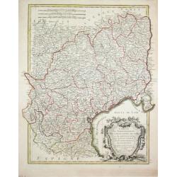
Carte des Gouvernements de Languedoc, de Foix et de Rousillon avec la Partie Oreintale du Gouvernement de Guienne.
Jean Lattré, Paris-based engraver and publisher. Worked with Robert de Vaugondy, J. Janvier and R. Bonne. " Atlas Monderne', 1771, 1783 , 1793. Rigobert Bonne (1727...
Date: Paris, 1783.
Selling price: ????
Please login to see price!
Sold
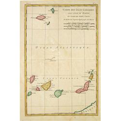
Carte des Isles Canaries, avec l'Isle de Madere et celle de Porto Santo
Rigobert Bonne (1727-1795), French cartographer. His maps are found in a.o. Atlas Moderne (1762), Raynal's Histoire Philos. du Commerce des Indes (1774) and Atlas Encyclo...
Date: Paris, 1784.
Selling price: ????
Please login to see price!
Sold
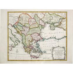
Nieuwe en Naauwkeurige Kaart / van / EUROPEËSCH TURKYE / benevens de aangrenzende Landen / Hongaryen, Zevenbergen, / Klein Tartarye enz.
Willem Albert Bachiene (1712-1783), Dutch geographer in Maastricht. Most important work ' Heilige Geographie', a work on the Holy Land. Mathijs Schalenkamp published in 1...
Date: Amsterdam, 1785.
Selling price: ????
Please login to see price!
Sold
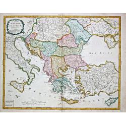
Carte de l' Empire de Turquie en Europe.
Pierre Bourgoin, Paris-based engraver and publisher. Published in 1784 his uncommon ' Atlas Élémentaire de la Géographie'. After his death his widow continued the busi...
Date: Paris, 1788.
Selling price: ????
Please login to see price!
Sold
The North Prospect of the City of Edinburgh.
A very fine and quite large view of Edinburgh from Joannes Kip's Britannia Illustrata or Views of Several of the Queens Palaces also of the Principal Seats of the Nobilit...
Date: London 1708-20
Selling price: ????
Please login to see price!
Sold
Pascaarte vande Noorder Zee Custen van America, vande West-Hoeck van Ysland doorde...
Fourth and last edition of van Keulen's chart of the Arctic Canada with the Hudson Bay and the supposed Northwest Passage. First published in 1680. The map is based upon ...
Date: Amsterdam, 1728-80
Selling price: ????
Please login to see price!
Sold in 2020
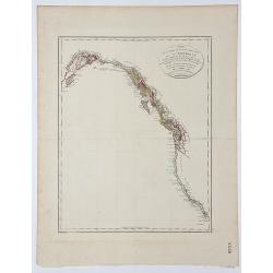
Carte de la partie de la Cote nord-ouest de l' Amerique.
A detailed and rare map of the Gulf of Alaska, British Columbia, and south to St.Francisco. Prepared by Edward Roberts after information by George Vancouver and engraved ...
Date: Paris, ca. 1800
Selling price: ????
Please login to see price!
Sold in 2017
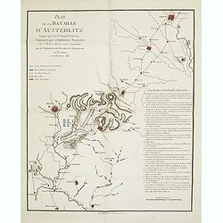
Plan de la bataille d'Austerlitz gagnée par la gde armée française commandée par l'empereur Napoléon sur l'armée austro-russe commandée par les empereurs de Russie et d'Allemagne en personnes le 11 frimaire XIV.
Map of the Battle of Austerlitz of 1805. With a color-key to the French, Russian and Austrian armies. Explicative key for the battle in lower right: A-Q and a -d. prepare...
Date: Paris, 18056
Selling price: ????
Please login to see price!
Sold in 2013
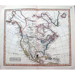
North America.
An interesting steel engraved map showing Mexico reaching until Mendocino and Utah Lake! Locates Texas, Cabo San Lucas, New Madrid in Missouri, etc. Names Indian nations,...
Date: Anon, ca 1820?
Selling price: ????
Please login to see price!
Sold in 2018
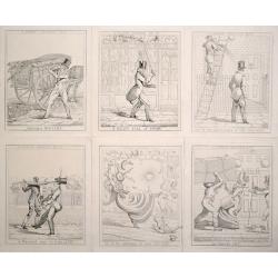
(Complete set of 6) A London Nuisance.
Scarce and amusing series of 6 plates depicting the dangers of the London streets.Complete set of 6 "A London Nuisance", etchings by Richard Dighton, plates 1-6...
Date: London, 1821
Selling price: ????
Please login to see price!
Sold in 2014
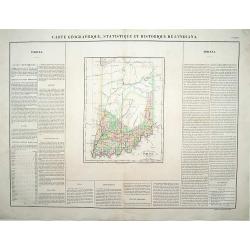
Carte Géographique .. Indiana.
\"Detailed map of Indiana. From J.A. Buchon, \"\"Atlas Gégraphique Statistique, historique et chronologique des deux Ameriques et des isles adjacentes; tr...
Date: Paris 1825.
Selling price: ????
Please login to see price!
Sold
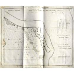
Land District North of Red River in the Sate of Louisiana.
An unusual map from an American land survey report, surveyed in 1823 by Maxfield Ludlow, and ordered by The House of Commons in 1827. It shows the Mississippi River with ...
Date: London, 1828?
Selling price: ????
Please login to see price!
Sold in 2018
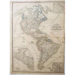
CARTE GENERALE des Deux Ameriques.
An interesting old colored lithographed map of the American continent, with the Independent Texas Republic. From a french atlas by G.Heck.There are 3 inset maps of - the ...
Date: Paris, ca 1835
Selling price: ????
Please login to see price!
Sold in 2021
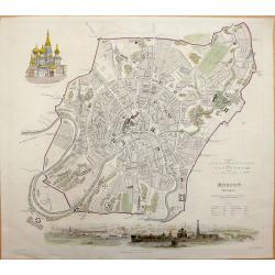
Moscow MOCKBƃI W. B. Clarke for S.D.U.K.- General Atlas...of The Society for the Diffusion of Useful Knowledge.
Very attractive engraved plan of the city centered on the Kremlin. All major streets, many public places, and buildings named. Details shown on many of the fortified area...
Date: London, 1836
Selling price: ????
Please login to see price!
Sold in 2013
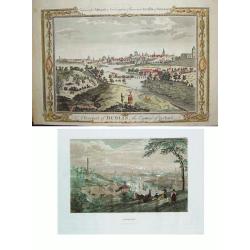
LOT of 2: 1) A Prospect of Dublin the Capital of Ireland 2) Dublin
Two wonderful views of Dublin offered as one lot. Item 1) shows the Liffey River winding through the city. The foreground is filled with citizens, some wealthy and othe...
Date: Item 1) London, ca. 1780. Item 2) Philadelphia, dated 1838.
Selling price: ????
Please login to see price!
Sold in 2010

Washinga Sahba's Grab.../ Tombeau de Wachinga Sahba.../ Washinga Sahba's Grave on Blackbird's Hill.
Aquatint from: 'Reise in das innere Nord-America in den Jahren 1832-1834' by Prince Maximilian of Wied-Neuwied, after paintings by Karl Bodmer, engraved by Lucas Weber, p...
Date: London, 1842
Selling price: ????
Please login to see price!
Sold in 2016
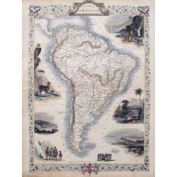
South America.
Detailed map of South America from the famous Atlas by John Tallis. With many place names, regions, and countries shown.Highly decorative map with ornamental borders, sev...
Date: London, ca. 1850
Selling price: ????
Please login to see price!
Sold in 2015
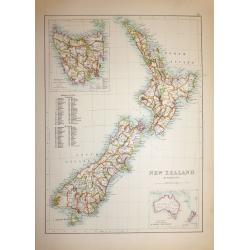
New Zealand & Tasmania
A superb map of New Zealand drawn and engraved by William Hughes – Sidney Hall steel engraved. Published by Adam & Charles Black in ‘General Atlas of the World’...
Date: Edinburgh, 1854
Selling price: ????
Please login to see price!
Sold in 2019
Ducato di Lucca.
Very finely engraved and detailed map of the Duche of Lucca during the Roman and Middle Age period. Lower left part of the map, two inset lists of the localities names us...
Date: Rome 1860.
Selling price: ????
Please login to see price!
Sold

A set of 12 prints of the country seats of the Noblemen & Gentlemen of Ireland
A set of 12 original 1870 color prints from The Rev. F.O. Morris work “A Series of Picturesque Views of Seats of the Noblemen & Gentlemen of Great Britain and Irela...
Date: London & Dublin, 1870
Selling price: ????
Please login to see price!
Sold in 2017
Trigonometrical Branch Survey of India, Sheet No6 of North Eastern Frontier Parts of Tibet, Sikhim and Bhutan
A well-used map of the area surrounding Lhasa. Published under the direction of Colonel G. C. De Pree, Surveyor General of India.
Date: Dehra Dun, 1885
Selling price: ????
Please login to see price!
Sold in 2016
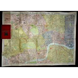
Gall & Inglis Reduced Ordnance Map of London
A large scale folding map of London, published in London by Gall & Inglis in the form of a pocket book. The map is backed, both sides, and the main map is in full ori...
Date: London, 1890
Selling price: ????
Please login to see price!
Sold in 2016
![INFLUENCE DE L'INFLUENZA SUR L'EUROPE. [The influence of Flu on Europe]](/uploads/cache/84679-250x250.jpg)
INFLUENCE DE L'INFLUENZA SUR L'EUROPE. [The influence of Flu on Europe]
A 1890's rare chromolithographed humouristic map on a flu pandemic in Europe. Published by the French satiric paper 'Le Troupier' in Paris.The largest nineteenth-century ...
Date: Paris, ca 1890
Selling price: ????
Please login to see price!
Sold in 2020

A set of 20 humorous prints from the Russian Empire's war with the French and British Empire's and beyond
This set of 20 are dated between 1855-1894. Mostly engraved by Joseph Swain. Joseph Swain was one of the most important woodblock engravers. Punch was responsible for the...
Date: London, 1855 - 1894
Selling price: ????
Please login to see price!
Sold in 2016

A set of 15 humorous prints. 1846, 1857, 1858, 1862, 1863, 1864, 1866. 1882, 1896. All with American, Civil War, Oregon Treaty and Abraham Lincoln interest
A set of 15 humorous prints. 1846, 1857, 1858, 1862, 1863, 1864, 1866. 1882, 1896. All with American, Civil War, Oregon Treaty and Abraham Lincoln interest.Mostly engrav...
Date: London 1846 - 1896
Selling price: ????
Please login to see price!
Sold in 2015
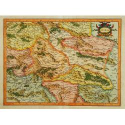
Stiria.
Detailed map of Styria, the most eastern part of Austria, centred on Graz.Signed lower right hand corner Per Gerardum Mercatorem Cum Privilegio.
Date: Amsterdam 1639-44
Selling price: ????
Please login to see price!
Sold
Hibernia regnum vulgo Ireland.
Fine map of Ireland with large coat of arms.
Date: Amsterdam 1639-44
Selling price: ????
Please login to see price!
Sold
![Scotiae pars Septentrionalis. [2 Maps]](/uploads/cache/16215-250x250.jpg)
Scotiae pars Septentrionalis. [2 Maps]
Detailed map in two sheets depicting the Northern part of Scotland.
Date: Amsterdam 1639-44
Selling price: ????
Please login to see price!
Sold
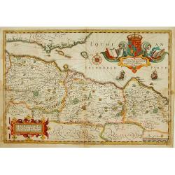
A New Description of the Shyres Lothian and Linlitquo. Be T.Pont.
A Scottish clergyman, Timothy Pont's survey of Scotland of 1595-1608 made that country the best mapped in the world. However it was not until Blaeu issued the maps as Vol...
Date: Amsterdam 1639-44
Selling price: ????
Please login to see price!
Sold
Uplandia.
Covers the area of the modern Uppsala, the vicinity of Stockholm, and includes most of Aland.
Date: Amsterdam 1639-44
Selling price: ????
Please login to see price!
Sold
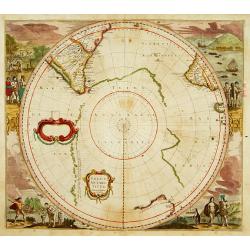
POLUS ANTARCTICUS.
With vignettes of natives within corners. This is the first printed map as far as I know to show the discovery of Peter Nuyts land, or part of the south coast of Australi...
Date: Amsterdam 1639-44
Selling price: ????
Please login to see price!
Sold
!["Nederlandsch West - Indië. [7 maps on one sheet, including Curaç.]"](/uploads/cache/15951-250x250.jpg)
"Nederlandsch West - Indië. [7 maps on one sheet, including Curaç.]"
"An excellent engraving of the Dutch possessions in the West Indies. Seven maps on one sheet, Surinam, St. Martin, Bonaire, Curaç, Aruba, St.Eustatius and...
Date: The Netherlands c.1900.
Selling price: ????
Please login to see price!
Sold
Carta de las islas Baleares..
Very detailed and rare map, engraved by E. Perez, showing the islands of Majorca, Minorca and Ibiza. Lighthouses and soundings contemporary colored in yellow and red. Ver...
Date: Madrid, Deposito Hidrografico, 1900.
Selling price: ????
Please login to see price!
Sold
![No title: [Minorca]](/uploads/cache/16334-250x250.jpg)
No title: [Minorca]
Geological map showing the island Minorca printed in out-line colors. Very interestingly in the lower left hand bottom a manuscript key to the different geological ages i...
Date: Paris, c. 1920.
Selling price: ????
Please login to see price!
Sold
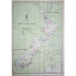
New Zealand
An interesting map of New Zealand’s North and South Islands, complete with an inset map of New Zealand’s position in the South Pacific Ocean. Printed by W. A. G. Skin...
Date: Wellington, 1932
Selling price: ????
Please login to see price!
Sold in 2018
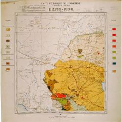
Carte geologique de l'Indochine. Bang-Kok est.
Geological or soil map showing part of Bangkok , including in the left and right margins a colored legend with signs of the different geological ages. Heliography and pri...
Date: Service geographique de l'Indochine, fevrier 1939.
Selling price: ????
Please login to see price!
Sold in 2009

4 London Transport related maps.
‘Railways Diagram of Lines’ dated January 1951 (The London Underground) 225 x 150 mm.‘Bus Map Country Area’ June 1952, 570 x 430 mm.‘Bus Map Central Area Includ...
Date: London, 1951 -1952
Selling price: ????
Please login to see price!
Sold in 2016
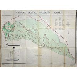
Nairobi Royal National Park.
A large plan of Nairobi National Park, first edition September 1956. A key shows the physical make up of the park plus a list of Mammals and Reptiles found in the park.
Date: Nairobi, 1956
Selling price: ????
Please login to see price!
Sold in 2019
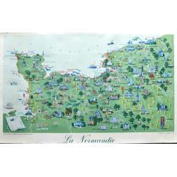
La Normandie.
A nice large poster of the area of Normandy. A fantastic pictorial map with many illustrations. Also includes dates of the battles in the 2nd World War. Below it reads: P...
Date: Paris, ca 1960?
Selling price: ????
Please login to see price!
Sold in 2021
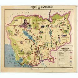
Royaume du Cambodge, carte touristique.
Decorative pictorial and Tourist map with points of interest shown pictorially. Figures monuments, animals, and beaches. Scale 1:1,000,000. Tite in upper margin, key at l...
Date: [Phnom Penh, Service ge´ographique des F.A.N.K., 1968]
Selling price: ????
Please login to see price!
Sold in 2020
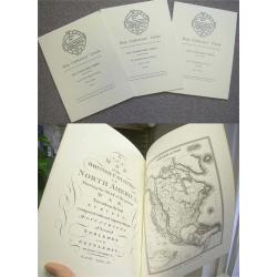
Printed Maps of America, Vols 1-3
Three editions dealing with America. Map Collectors' Circle Series Nos. 68, 69 and 80. Printed Maps of America. Parts 1,2 and 3. Soft Covers. Each publication measures 9�...
Date: London: 1971-1972.
Selling price: ????
Please login to see price!
Sold
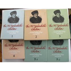
The AE Nordenskiold Collection: Annotated Catalogue of Maps made up to 1800.
Scarce! Complete set of books: volumes 1, 2, 3, 4, 5/1, and 5/2, plus accompanying softbound overview of collection. This is not often found for sale as a complete set,...
Date: Helsinki University Library: Stockholm, 1979-1995
Selling price: ????
Please login to see price!
Sold in 2013
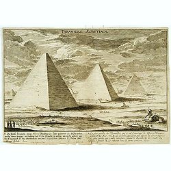
Pyramides Aegyptiacae.
An imaginary view.
Date: (19th)
Selling price: ????
Please login to see price!
Sold
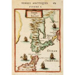
Terre de Iesso.
"A charming small map of Hokkaido and the northern part of Honshu. With four western ships in the sea, by Allain Manneson Mallet (1630-1706), a well travelled milita...
Date: MALLET,A.M.
Selling price: ????
Please login to see price!
Sold

Bombardement de la Citadelle d'Anvers.
Engraving showing the attack of the citadel of Antwerp in November 1832.
Date: Paris
Selling price: ????
Please login to see price!
Sold in 2016
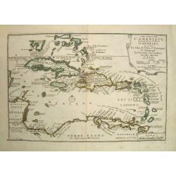
Les Isles De L'Amerique.
"Les Isles De L'Amerique Connues Sous le Nom D'Antilles, ou Sont les Isles de Cuba, St. Domingue et Jamaique les Lucayes, les Caribes."An elegant map of the Car...
Date: 1705, Paris
Selling price: ????
Please login to see price!
Sold in 2019

Harpers Christmas.
Les Affiches Étrangères were printed in 1895-1896 by Jules Cheret of the Chaix Imprimerie. The plates are printed in stone lithography. "Harpers Christmas" st...
Date: 1897 paris
Selling price: ????
Please login to see price!
Sold in 2021
![[Africa - General continental map with Ottoman script]](/uploads/cache/44735-250x250.jpg)
[Africa - General continental map with Ottoman script]
Post card size map in Ottoman script showing the continent of Africa from Mehmet Eşref’s ‘Küçük Atlas’, a rare portfolio of loose-leaf maps wit...
Date: Istanbul, Şirket-i Mürettibiye ve Karacoğlu Matbaas&#
Selling price: ????
Please login to see price!
Sold
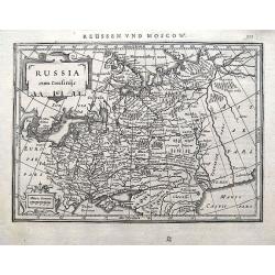
Russia cum Confiniis.
An early map of western Russia from the "Atlas Minor" (Gerhard Mercator / Jodocus Hondius). Extends from Lappland until the Caspian Sea. With two small cartouch...
Date: Amsterdam, 1609 or later
Selling price: ????
Please login to see price!
Sold in 2018
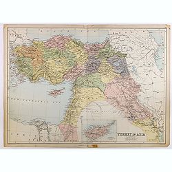
Turkey in Asia.
Very detailed map of Turkey. Inset of Cyprus. The map was printed from lithographic stones taken from a hand-engraved steel plate. The cartographer John Bartholomew of Ed...
Date: Edinburg
Selling price: ????
Please login to see price!
Sold in 2017
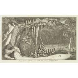
Marmere grot op het eiland Antiparos.
Marble Cave of Antiparos, who is an island in the island group Cyclades in the Aegean Sea, in the modern eparchy of Naxos. The cave itself, which is about 150 feet by 100...
Date: Amsterdam, c.17
Selling price: ????
Please login to see price!
Sold in 2014
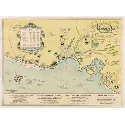
Montego Bay Jamaica, B.W.L.
Beautiful vintage pictorial tourist map of the Montego Bay in Jamaica, with key to distances to hotels and guest houses. In lower part publicity for railway and motor car...
Date: London,
Selling price: ????
Please login to see price!
Sold in 2020
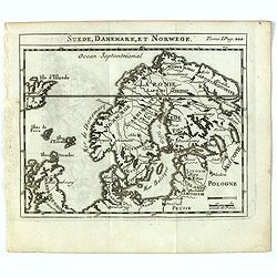
Suede, Danemark, et Norwege.
Scarce small map of Scandinavia based on cartography of Guillaume Delisle (. Published in "Nouveau traité de geographie par M**** ", published by La veuve Lott...
Date: Paris, La veuve Lottin & Butard, P.G. Le Mercier, Rollin, David, Delag
Selling price: ????
Please login to see price!
Sold in 2016
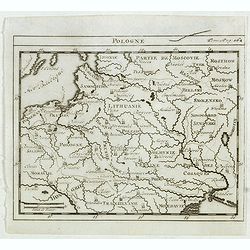
Pologne.
Scarce small map of Poland based on cartography of Guillaume Delisle. Published in "Nouveau traité de geographie par M**** ", published by La veuve Lottin &...
Date: Paris, La veuve Lottin & Butard, P.G. Le Mercier, Rollin, David, Delag
Selling price: ????
Please login to see price!
Sold in 2015

Engraving
Engraving showing Clio, one of the 9 Muses from Greek Mythology. From the series of the Muses, nr. 89 By Goltzius (1558-1616)
Date: 17 th. cent.
Selling price: ????
Please login to see price!
Sold
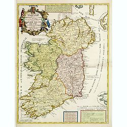
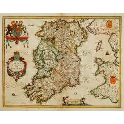
Le Royaume d'Irlande..
Uncommon map of Ireland. A visually stunning map with a large title cartouche. This large one-sheet map was produced by the Venetian cosmographer Vincenzo Coronelli when ...
Date: Paris 1690 / CORONELLI,P.
Selling price: ????
Please login to see price!
Sold
Lot of 3 maps of Germany.
Robert de Vaugondy: Empire d'Allemagne, 24 cm x 28 cm. Van der AA : Cercle du Haut Rhin, 22,5cm x 29 cm: L'Allemagne, 22,5 cm x 29 cm.The three maps are well-engraved.
Date: Paris/ Leiden
Selling price: ????
Please login to see price!
Sold
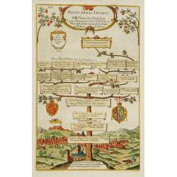
Reges Arpag Veteres..
A family tree of the rulers of Aragon starting with Ennicus (832-861). In lower part a view of Burgos.
Date: England
Selling price: ????
Please login to see price!
Sold
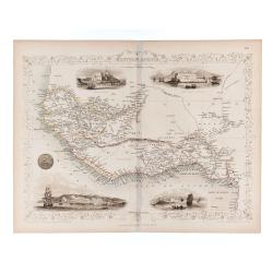
Western Africa.
Double page steel engraved map. Map accompanied by vignette scenes of Christiansborg, Cape Coast Castle, Sierra Leone and Bakel. Decorative scrolling and title cartouche ...
Date: London & New York: The London Printing and Publish
Selling price: ????
Please login to see price!
Sold in 2020
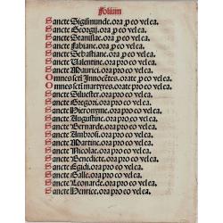
Saints page from Book of Hours
Saints page from a Book of Hours Latin text in Black and red ink
Date: Unknown
Selling price: ????
Please login to see price!
Sold
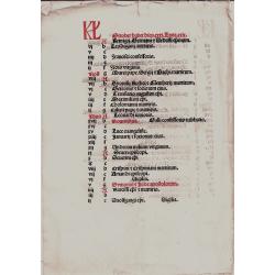
Calendar page September/ October
Calendar leaf from a Book of Hours for the month of September and October Latin text in Black and red ink
Date: France, unknown
Selling price: ????
Please login to see price!
Sold
![[Bottom of Very Large Map] The Duchy of Brabant.](/uploads/cache/98717-250x250.jpg)
[Bottom of Very Large Map] The Duchy of Brabant.
This the bottom of a very large English map showing the following regions: Duchy of Brabant, Luxemburg, Duchy of Limburg, Bishoprick, French Flanders, County of Artois, C...
Date: Unknown
Selling price: ????
Please login to see price!
Sold in 2017
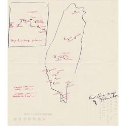
Outline map of Formosa.
An unusual hand drawn map of Formosa.
Date: Kagi City, Formosa
Selling price: ????
Please login to see price!
Sold in 2019
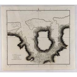
Sketch of the Harbours on the North Side of Eimeo (Taloo Harbour).
A chart showing what is now called Cook's Bay on the island of Moorea (Society Islands) in the French Polynesia. This chart appeared in; "A Voyage to the Pacific Oce...
Date: New York,
Selling price: ????
Please login to see price!
Sold in 2019
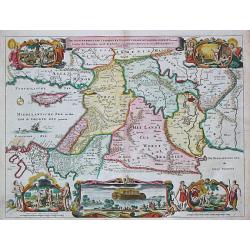
De Gelegentheyt van t' Paradys en t' Landt Canaan, mitsgaders d' eerst bewoonde Landen der Patriarchen.
Dutch so-called "Staten" bibles, published between 1637 and c. 1760, contained 5 maps: The World, "Paradise", The Perigrinations, The Promised Land Ca...
Date: Amsterdam / Dordrecht, Pieter Keur, Pieter Rotterdam em Pieter Rotterd
Selling price: ????
Please login to see price!
Sold