Browse Listings
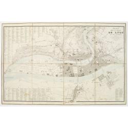
Plan de la Ville de Lyon, et ses environs, réduit d'apres les meilleurs levés, corrigé, augmenté et gravé d'après des plans particuliers et des reconoissances faites sur les lieux.
With the title at upper right, an alphabetical street index at upper left, an index of other features at lower left and right, and a scale of metres at lower right, the r...
Date: Lyon, chez Midan libraire, 1830
Selling price: ????
Please login to see price!
Sold

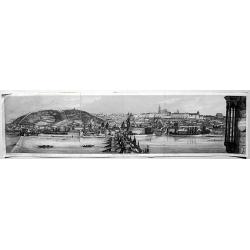
Vue de Vienne prise du cote du chateau de Schonbrunn.
Spectacular view of Vienna. Engraved by Schwartz, after a design of Hügl. Published by Bannee & Schrot, active in Rue du Mail, Paris.
Date: Paris c.1830
Selling price: ????
Please login to see price!
Sold
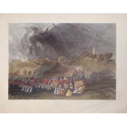
![[British soldiers in India].](/uploads/cache/14500-250x250.jpg)
[British soldiers in India].
A decorative print showing a group of English soldiers being attacked by Indian locals. After design of A. van Eschen. From a series Englischer Dienst. 10 Service d'Angle...
Date: Germany, c.1830
Selling price: ????
Please login to see price!
Sold in 2011
![[Dutch soldiers in Indonesia].](/uploads/cache/14501-250x250.jpg)
[Dutch soldiers in Indonesia].
A decorative print showing a group of Dutch soldiers and 2 locals returning to their vessel. After design of A. van Eschen. From a series Hö:llandischer Dienst. 1...
Date: Germany c.1830
Selling price: ????
Please login to see price!
Sold

Service de France. 3éme Régiment Fusiliers1812
A decorative print showing a group of French soldiers. After design of A. van Eschen. From a series Service de France .
Date: Germany c.1830
Selling price: ????
Please login to see price!
Sold
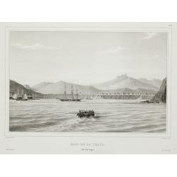
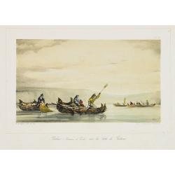
Baie de la praya. (Ile San lago.).
View of the Cape Verde from Voyage de la corvette l’Astrolabe exécuté par Ordre du Roi pendant les années 1826 – 1827 – 1828 – 1829 sous le commandement de M. ...
Date: Paris, 1830
Selling price: ????
Please login to see price!
Sold in 2011
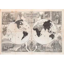
Welt-karte der Mission.
Shows the four continents with the missions. Very decorative. Rare.
Date: Germany, 1830
Selling price: ????
Please login to see price!
Sold in 2015
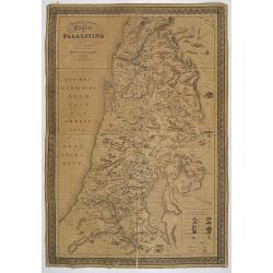
Topographisch-historische Charte von Palaestina. . .
First German text edition of this very decorative, large map of Palestine, edited by the German orientalist and theologian Ernst Friedrich Karl Rosenmüller (1768-1835), ...
Date: Leipzig, Baumgärtners Buchhandlung, 1830
Selling price: ????
Please login to see price!
Sold in 2008

Notre-Dame de gloire. (à Rio de Janeiro).
Beautiful Brazilian landscape with the Notre-Dame de gloire church in background. After Auguste Borget (1808-1877), in upper right corner "Plate 2".
Date: Moulins, ca. 1830
Selling price: ????
Please login to see price!
Sold in 2008
Balsas (Bateaux de Pêche) sur la Côte de Bolivie.
A fishing scene along the Bolivian coast. After Auguste Borget (1808-1877), in upper right corner " Plate 10."
Date: Moulins, ca. 1830
Selling price: ????
Please login to see price!
Sold in 2009
![[ A manuscript map of the Arabian Peninsular. ]](/uploads/cache/26537-250x250.jpg)
[ A manuscript map of the Arabian Peninsular. ]
Large scale map of southern half of Arabian Peninsular, including Bahrain, Oman, etc. To the left the River Nile.
Date: Germany, c. 1830
Selling price: ????
Please login to see price!
Sold in 2008

Iles Viti et Nlle Irlande.
From "Voyage de la corvette l'Astrolabe exécuté par Ordre du Roi pendant les années 1826 - 1827 - 1828 - 1829 sous le commandement de M. Jules Dumont d'Urville, C...
Date: Paris, 1830
Selling price: ????
Please login to see price!
Sold in 2011

Amboine.
From "Voyage de la corvette l'Astrolabe exécuté par Ordre du Roi pendant les années 1826 - 1827 - 1828 - 1829 sous le commandement de M. Jules Dumont d'Urville, C...
Date: Paris, 1830
Selling price: ????
Please login to see price!
Sold in 2011
![[No title] Russland. Gouv. 31. Taurien und 31a das Land der Tschernomorkischen Kosaken.](/uploads/cache/28947-250x250.jpg)
[No title] Russland. Gouv. 31. Taurien und 31a das Land der Tschernomorkischen Kosaken.
Map depict the area north of the Black Sea, including the sea of Azov and the cities of Akhmetschet, Kaffa, Jekaterinodar, Kherson, etc.From "W. E. A. von Schliebens...
Date: Leipzig, G. J. Göschen, ca 1825-1830
Selling price: ????
Please login to see price!
Sold in 2013
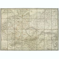
Post Reise Karte durch Deutschlandund die Angraenzenden Staaten. . .
post road maps map of Germany, Poland, the Low Countries, Switzerland and Austria. Folding map dissected in 8 sections, canvas mounted. The map is showing incredible deta...
Date: Vienna, 1830
Selling price: ????
Please login to see price!
Sold in 2011

Asia-Minor Shewing the Seven Apocalyptic Churches of Asia.
Interesting map of Turkey and Cyprus, with ancient place names. Locates the Seven Churches and other places mentioned in the New Testament.With a vignette view of Tarsus.
Date: London, c1830
Selling price: ????
Please login to see price!
Sold in 2012
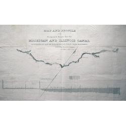
MAP AND PROFILE of the Proposed Route for the MICHIGAN AND ILLINOIS CANAL SURVEYED IN 1830 by W. B. GUION & H. BELIN CIVIL ENGINEERS reduced from the original drawing by J. R. IRWIN LIEUT. U.S.A.
Large scale plan of the Illinois Michigan Canal. Shows landmarks along its course. With the profile of Lake Michigan underneath the map. Unusual and interesting item!
Date: c1830
Selling price: ????
Please login to see price!
Sold in 2013

Vue du Kremlin.
Lithography showing the Kremlin in Moscow.
Date: Paris, 1830
Selling price: ????
Please login to see price!
Sold in 2014
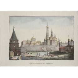
Vue intérieure du Kremlin.
Lithographie shows the Kremlin in Moscow.
Date: Paris, 1830
Selling price: ????
Please login to see price!
Sold in 2014
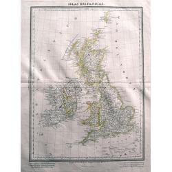
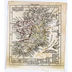
Islas Britanicas.
Very rare Spanish map of the British Isles by Domingo Estrue. With the longitudes east of Madrid. Very detailed map with towns, areas, roads, and many islands shown. Thi...
Date: Madrid, 1830
Selling price: ????
Please login to see price!
Sold in 2014
Winchelsea, Sussex.
Hand-colored steel engraving by J. Henshell after J.M.W. Turner featuring a scene of Winchelsea, Sussex.
Date: London, 1830
Selling price: ????
Please login to see price!
Sold in 2016

Hand-Colored Copper Engraving of Atlas With World On Shoulders.
This is an interesting hand-colored copper engraving of Atlas with the world on his shoulders. The world is a celestial globe.
Date: London, c1830
Selling price: ????
Please login to see price!
Sold in 2014
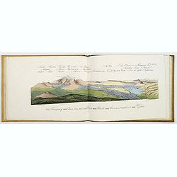
Vues et coupes des principales formations géologiques du département du Puy-de-Dôme... Atlas (only).
Geological atlas with 31 plates drawn by Lecoq and Bouillet, lithographed by Thibaud- Landriot and finely colored at the time of publication. Jean Baptiste Bouillet (1799...
Date: Paris, Levrault, Clermont-Ferrand, Bouillet, Thibaud-Landriot, 1830
Selling price: ????
Please login to see price!
Sold

Œillets flammands. N° 24.
Fine lithograph of roses by Godefroy Engelmann" after a drawing by Auguste Piquet de Brienne (1789-c.1860) . Published in Paris at rue Montmartre 6, after 1829.Godef...
Date: Paris, 1830
Selling price: ????
Please login to see price!
Sold in 2015

Lys, Rose mousseuse et Pensée. N° 15.
Fine lithograph of roses by Godefroy Engelmann" after a drawing by Auguste Piquet de Brienne (1789-c.1860) . Published in Paris at rue Montmartre 6, after 1829.Godef...
Date: Paris, 1830
Selling price: ????
Please login to see price!
Sold in 2015

Rose blanche. N° 16.
White Rose. Fine lithograph of roses by Godefroy Engelmann" after a drawing by Auguste Piquet de Brienne (1789-c.1860) . Published in Paris at rue Montmartre 6, afte...
Date: Paris, 1830
Selling price: ????
Please login to see price!
Sold in 2015

Rose capucine. N° 17.
Fine lithograph of roses by Godefroy Engelmann" after a drawing by Auguste Piquet de Brienne (1789-c.1860) . Published in Paris at rue Montmartre 6, after 1829.Godef...
Date: Paris, 1830
Selling price: ????
Please login to see price!
Sold in 2015

Rose jaune à cent feuilles. N° 365.
Yellow roses. Fine lithograph of roses by Godefroy Engelmann" after a drawing by Auguste Piquet de Brienne (1789-c.1860) . Published in Paris at rue Montmartre 6, af...
Date: Paris, after 1830
Selling price: ????
Please login to see price!
Sold in 2015

Coriope de Virginie. N° 66.
Decorative and early lithography of a bouquet of flowers. Fine lithograph of roses by Godefroy Engelmann" after a drawing by Auguste Piquet de Brienne (1789-c.1860) ...
Date: Paris, 1830
Selling price: ????
Please login to see price!
Sold in 2021

Phlox de la Caroline. N° 55.
Bouquet of flowers. Lithograph by Godefroy Engelmann" after a drawing by A. Brienne. Godefroy Engelmann was born in 1788 in Mühlhausen, a small town near the France...
Date: Paris, ca. 1830
Selling price: ????
Please login to see price!
Sold in 2015
![[No title, showing Majorca, minorca and part of the coast of Algaria.]](/uploads/cache/35723-250x250.jpg)
[No title, showing Majorca, minorca and part of the coast of Algaria.]
Very detailed folding map with map of Majorca, Minorca and part of the coast of Algeria. In upper left Spanish coast with Barcelona.
Date: France, c.1830
Selling price: ????
Please login to see price!
Sold in 2015
America entworfen von C. G. Reichard...
Unusual German map of the Americas, published in an early edition of Stielers Hand-Atlas. Dated 1816, improved 1828. Includes interesting details in North America, for e...
Date: Gotha, ca. 1830
Selling price: ????
Please login to see price!
Sold in 2015
The World as Known to the Ancients, Egypt with Libya & The East (3 Maps)
Three fine Holy Land maps by Sidney Hall. Sidney Hall (1788–1831) was a British engraver and cartographer well known and popular for his early nineteenth century atlase...
Date: London, ca. 1830
Selling price: ????
Please login to see price!
Sold in 2018
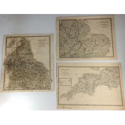
Three S.D.U.K. Maps - England I, England III & England IV
Three detailed maps of England by S.D.U.K. published in London in 1830 by Chapman & Hall and engraved by John Walker. “England I” covers Northumberland, Cumberla...
Date: London, 1830
Selling price: ????
Please login to see price!
Sold in 2016
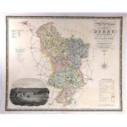
Map of the County of Derby, from an Actual Survey made in the Years 1824 & 1825. By C. & I. Greenwood.
A large map with decorative title at upper right, and a large vignette view of Chatsworth House at lower left. Published by Greenwood & Co. in London in 1830. Engrav...
Date: London, 1830
Selling price: ????
Please login to see price!
Sold in 2016
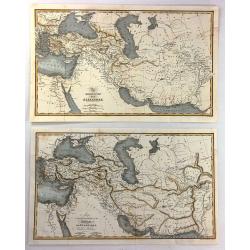
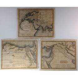
(2 Maps) - The Expedition of Alexander & Map To Illustrate the History of the Assyrians, Babylonians, Medes and Persians
Two interesting historical maps of North Africa and the Middle East at different times in history. “The Expedition of Alexander” covers the time from 334BC through t...
Date: London, c1830
Selling price: ????
Please login to see price!
Sold in 2016
Lengyel Fold
Small Hungarian map of Poland and Lithuania. Major cities and towns depicted in red, mountains, rivers, woodlands and forests are also highlighted in color.
Date: ca. 1830
Selling price: ????
Please login to see price!
Sold in 2016
Prag (without a title).
A rare, fascinating view of Prag, from the "Buchhandlung of A. Borroschs", engraved by J. Hyrtl in Vienna, 1830.
Date: Vienna, 1830
Selling price: ????
Please login to see price!
Sold in 2018
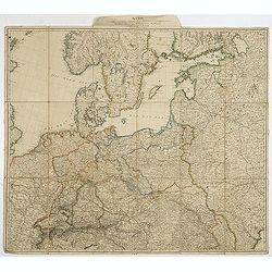
Karte des mittlern und östlichen Europa, von der Seine bis an der Dnieper. . .
Detailed map of the north west of Europe centered on Poland and Lithuania. The map is prepared by D.G. Reymann and published in Berlin by Simon Schropp & Co.A road sy...
Date: Berlin, ca. 1830
Selling price: ????
Please login to see price!
Sold in 2018
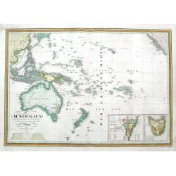
Australien nach Krusenstern, Flinders, Freycinet, Oxley. . .
A scarce early edition of this detailed German map of Australia and Oceania. It extends to show the entire southern Pacific Ocean, from China to California, including Jap...
Date: Weimar, 1830
Selling price: ????
Please login to see price!
Sold in 2018
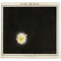
B.C. 2348. The deluge.
Plate from "An historical atlas: in a series of maps of the world as known at different periods constructed upon a uniform scale and colored according to the politic...
Date: London, 1830
Selling price: ????
Please login to see price!
Sold in 2020
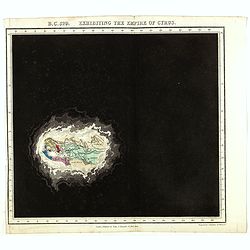
B.C. 529. Exhibiting the Empire of Cyprus.
Plate from An historical atlas: in a series of maps of the world as known at different periods constructed upon an uniform scale and colored according to the political ch...
Date: London, 1830
Selling price: ????
Please login to see price!
Sold in 2024
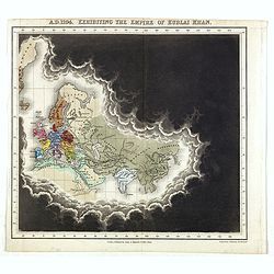
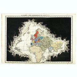
A.D. 1294. Exhibiting the Empire of Kublai Khan.
Plate from An historical atlas: in a series of maps of the world as known at different periods constructed upon an uniform scale and colored according to the political ch...
Date: London, 1830
Selling price: ????
Please login to see price!
Sold in 2020
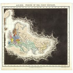
A.D. 1100. Period of the first crusade.
Plate from An historical atlas: in a series of maps of the world as known at different periods constructed upon an uniform scale and colored according to the political ch...
Date: London, 1830
Selling price: ????
Please login to see price!
Sold in 2023
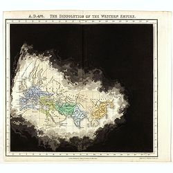
A.D. 476. The dissolution of the Western Empire.
Plate from An historical atlas: in a series of maps of the world as known at different periods constructed upon an uniform scale and colored according to the political ch...
Date: London, 1830
Selling price: ????
Please login to see price!
Sold in 2024
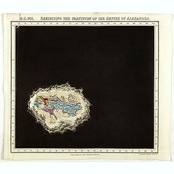
B.C. 301. Exhibiting the partitionof the Empire of Alexander.
Plate from An historical atlas: in a series of maps of the world as known at different periods constructed upon an uniform scale and colored according to the political ch...
Date: London, 1830
Selling price: ????
Please login to see price!
Sold
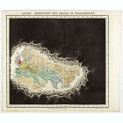
A.D. 814. Exhibiting the Empire of Charlemagne.
Plate from An historical atlas: in a series of maps of the world as known at different periods constructed upon an uniform scale and colored according to the political ch...
Date: London, 1830
Selling price: ????
Please login to see price!
Sold in 2024
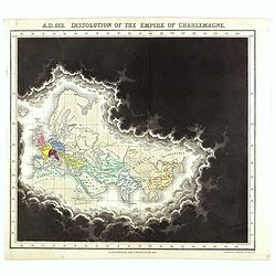
A.D. 912. Dissolution of the Empire of Charlemagne.
Plate from An historical atlas: in a series of maps of the world as known at different periods constructed upon an uniform scale and colored according to the political ch...
Date: London, 1830
Selling price: ????
Please login to see price!
Sold in 2021
A.D. 1498. The discovery of America.
Plate from An historical atlas: in a series of maps of the world as known at different periods, constructed upon a uniform scale and colored according to the political ch...
Date: London, 1830
Selling price: ????
Please login to see price!
Sold
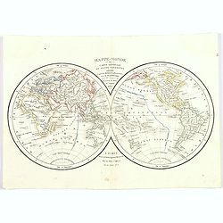
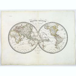
Mappe-Monde ou Carte Générale du Globe Terrestre.
World map in double hemispheres by F. Delamarche successor of Robert de Vaugondy. Continents in differing outline colors. A nice inexpensive world map from the first half...
Date: Paris, 1830
Selling price: ????
Please login to see price!
Sold in 2019
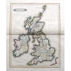
British Islands
Daniel Lizars fine map of the British Isles, pubslished by his son William Hole Lizars. With main roads, counties, cities, etc.
Date: Edinburgh, ca. 1830
Selling price: ????
Please login to see price!
Sold in 2019
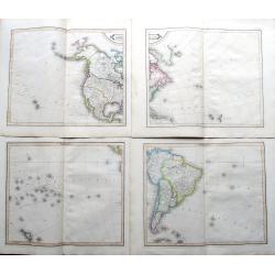
America.
Lizar's fantastic 4-sheet map of the Americas, pubslished by Daniel Lizars son, William Hole Lizars. The map shows an unfinished coast lines towards the Northwest Passage...
Date: Edinburgh, ca 1830
Selling price: ????
Please login to see price!
Sold in 2019
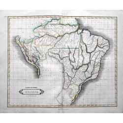
Lower Peru, Brazil & Paraguay.
Daniel Lizars fine map of Brazil, Paraguay, and parts of Peru, pubslished by his son William Lizars. With mountains, rivers, areas, cities, etc. Bolivia and Colombia left...
Date: Edinburgh, ca 1830
Selling price: ????
Please login to see price!
Sold in 2019
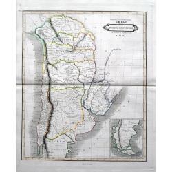
Bolivia or upper Peru; Chili and the United Provinces of South America or La Plata.
Daniel Lizars fine map of Bolivia, Chili, todays Argentina and Uruguay, pubslished by his son William Lizars. An inset map shows Patagonia. With the road from Valparaiso ...
Date: Edinburgh, ca 1830
Selling price: ????
Please login to see price!
Sold in 2019
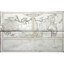
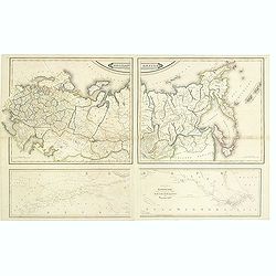
Russian Empire / Chart of the communication between the archipelago and Black Sea.
Large 2-sheet map (from 4 plates) of the Russian Empire, pubslished by Daniel Lizars son, William Hole Lizars. The unusual map shows Russia in great detail with many plac...
Date: Edinburgh, ca 1830
Selling price: ????
Please login to see price!
Sold in 2019
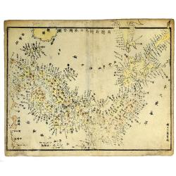
JAPAN, ca 1830.
Woodcut, colored map of Japan, with Japanese text.
Date: c 1830
Selling price: ????
Please login to see price!
Sold in 2019
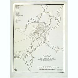
Plan de la Ville de Saigon. . .
An impressive large plan of the Vietnamese city of Saigon, produced and published by the Depot General de la Marine in Paris. Plan of the City of Saigon, fortified in 179...
Date: Paris, ca 1830
Selling price: ????
Please login to see price!
Sold in 2020
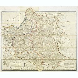
Charte von Polen nach seiner gegenwärtigen Eintheilung in das neue Königreich Polen, die übrigen russischen Besitzungen, das preussische. . . 1831
Rare folding case map of Poland and Lithuania for the year 1831. Very detailed, including a road system and a key in lower right corner. Published in Vienna, by the cousi...
Date: Vienna, 1831
Selling price: ????
Please login to see price!
Sold in 2012
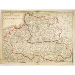
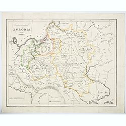
Carte des Etats de Pologne et du Grand Duché de Lithunanie.
Uncommon map of Poland prepared by Eustache Hérisson (1759-18.. ) and engraved by Cordier. The map was published by the last family member of the Jean publishing firm of...
Date: Paris, 1831
Selling price: ????
Please login to see price!
Sold in 2013
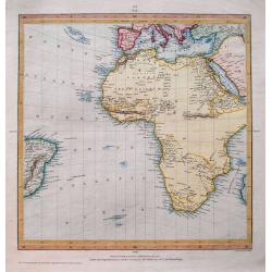
(Untitled map of Africa)
Fine map of Africa and the southern Atlantic. Includes a small part of Brazil, south Europe, and Arabia. Interesting map with large parts left blank in the interior of...
Date: London, 1831
Selling price: ????
Please login to see price!
Sold in 2014
![[Manuscript map without title] Map of the east Indian coast with Sri Lanka showing The Cousins Voyage 1831.](/uploads/cache/34583-250x250.jpg)
[Manuscript map without title] Map of the east Indian coast with Sri Lanka showing The Cousins Voyage 1831.
Manuscript map of the Indian coast with Ceylon (Sri Lanka) with the track of the vessel "Le Cousin" from Calcutta to Pondicherry and the retour voyage from Madr...
Date: Perhaps India, ca. 1831
Selling price: ????
Please login to see price!
Sold in 2014

Tulipa Suavéolens Tulipe Odorante.
Engraved by P.F.Legrand. From Plantarum succulentarum Historia: ou Histoire naturelle des plantes grasses, avec leurs figures en colors , by Pierre-Joseph Redouté's (175...
Date: Paris, 1799-1831
Selling price: ????
Please login to see price!
Sold in 2018
Carte des Etats de Pologne et du Grand Duché de Lithunanie.
Uncommon map of Poland prepared by Eustache Hérisson (1759-18.. ) and engraved by Cordier. The map was published by the last family member of the Jean publishing firm of...
Date: Paris, 1831
Selling price: ????
Please login to see price!
Sold in 2015
L'Europe a l'Epoque du Demembrement de L'Empire de Charlemagne.
Fine map featuring the empire of CHARLEMAGNE in Europe. It was developed by F. Delamarche in Paris in 1831. It was published in "ATLAS DE LA GEOGRAPHIE".
Date: Paris, 1831
Selling price: ????
Please login to see price!
Sold in 2017
Circumjacent the North Pole.
This map was produced by Society for the Diffusion of Useful Knowledge to update the latest discoveries in the Arctic. The northern regions are fairly well mapped by this...
Date: London, 1831
Selling price: ????
Please login to see price!
Sold in 2016
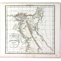
Egypt
Impressive map of Egypt by the Diffusion of Useful Knowledge, or S.D.U.K . It depicts Egypt, centered on the Nile River from the Mediterranean on the south as far as Nub...
Date: London, 1831
Selling price: ????
Please login to see price!
Sold in 2015
Aegypti Antique Tabula
A fine map of ancient Egypt, with the early names of the settlements along the Nile River, engraved by F. Delamarche and published in Paris in 1831.C.F. Delamarche (1740-...
Date: Paris, 1831
Selling price: ????
Please login to see price!
Sold in 2018
Mappe-Monde en deux hemispheres.
A double hemisphere World map, interestingly, with the Americas on the right, rather than the more common orientation. A first edition, produced by Lapie in Paris. With t...
Date: Paris, 1831
Selling price: ????
Please login to see price!
Sold in 2018
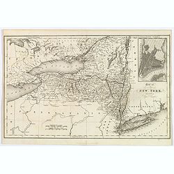
Map of the State of New York with part of Upper Canada.
A scarce early map of New York, showing towns, roads, rivers, lakes, mountains, islands, canals, etc. Inset map of Manhattan. One of the earliest separate maps of the sta...
Date: London, 1831
Selling price: ????
Please login to see price!
Sold in 2018
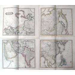
Asia
Lizar's fantastic 4-sheet map of Asia. From Turkey until the Philippines. Shows caravan routes through the Arabian desert, tremendous detail in Siberia, and small islands...
Date: Edinburgh, ca. 1831
Selling price: ????
Please login to see price!
Sold in 2019
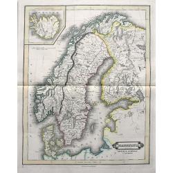
Scandinavia including Sweden, Norway & Denmark.
An excellent steel engraved map of Scandinavia, including the Baltics and St. Petersburg. An inset map shows Iceland.
Date: Edinburgh, ca 1831
Selling price: ????
Please login to see price!
Sold in 2019
Situazione attuale della Polonia 1831.
An unusual map of Poland by the Italian Bernardo Zaydler, published in the work History of Poland in 1831. The map extends from Prussia and Bohemia in the west, across th...
Date: Florence, 1831
Selling price: ????
Please login to see price!
Sold in 2023
![[Set of 9 maps of India]](/uploads/cache/20230514_144931-250x250.jpg)
[Set of 9 maps of India]
A set of 9 steel engraved maps of India published under the superintendence of the Society for the Diffusion of Useful Knowledge (SDUK), most sheets are early editions da...
Date: London, ca. 1831
Selling price: ????
Please login to see price!
Sold in 2023
J.R. Arsenale (Venice)
A superbly hand colored aquatint depicting the arsenal of Venice. It provides an excellent view of the architecture. Quite decorative.
Date: Venic, 1831
Selling price: ????
Please login to see price!
Sold in 2011
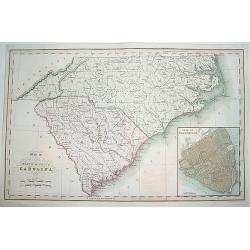
Map of the States of North & South Carolina..
An increasingly scarce map of North and South Carolina. This was one the first maps to provide accurate border divisions for the Carolina counties. Moreover, it was one o...
Date: London, 1831
Selling price: ????
Please login to see price!
Sold
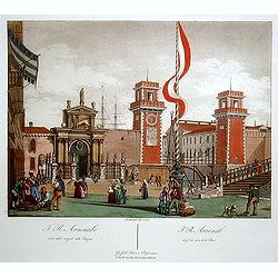
J.R. Arsenal. (Venice)
Superbly hand colored aquatint showing the arsenal of Venice. It provides a lovely view of the architecture.
Date: Venice 1831
Selling price: ????
Please login to see price!
Sold
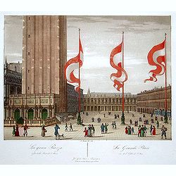
La Grande Place. (Venice)
"Superbly hand colored aquatint showing the ""Grande Place"" of Venice. It provides a lovely view of the architecture and the people walking in f...
Date: Venice 1831
Selling price: ????
Please login to see price!
Sold
Carta Topografica del lago di como e delle tre-Pievi.
A uncommon postal map centered on the lake of Como. Engraved by Giuseppe Pezze.
Date: Milan, c. 1831
Selling price: ????
Please login to see price!
Sold in 2011
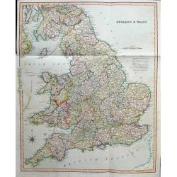
England & Wales
Large and highly detailed map of England & Wales, from Edinburgh to the French coast. Includes ferries to Ireland and Isle of Man, streets with distances between town...
Date: London, 1831
Selling price: ????
Please login to see price!
Sold in 2016
Russian empire. / Chart of the communication between the archipelago and black sea.
Printed on 2 sheets, each sheet has two maps printed from different copper plates. The lower map at 1:400,000 scale and includes northern part of the Black Sea with, Hell...
Date: Edinburg, 1831
Selling price: ????
Please login to see price!
Sold in 2014