Browse Listings
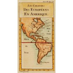
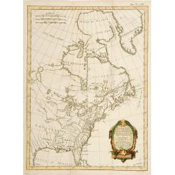
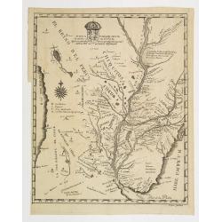
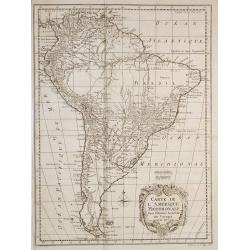
Les colonies des Européens en Amérique.
Map of the American continent showing the European settlements.
Date: Paris, c.1780
Selling price: ????
Please login to see price!
Sold

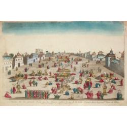
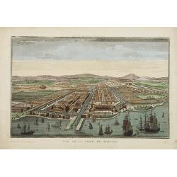
Gezicht van het West-Indisch-Huys, op de binnen plaats..
Taken from his Atlas of Amsterdam. Inside-square of the West Indian Company headquarters at Amsterdam. Several traders are shown
Date: Amsterdam 1780
Selling price: ????
Please login to see price!
Sold
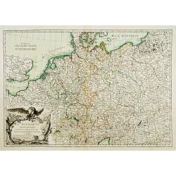
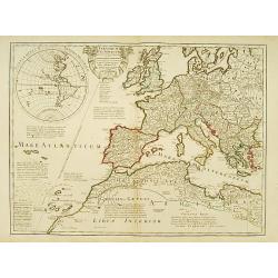
L'Alemagne divisée... / Carte de l'Empire d'Alemagne?
2 decorative maps of Germany with nice title cartouches.
Date: Paris c.1780
Selling price: ????
Please login to see price!
Sold
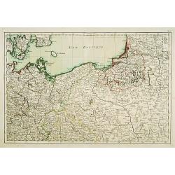
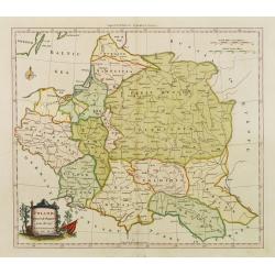
(Map of Poland and Prussia.)
Map centered on the Baltic depicting Prussia and North Poland.
Date: Paris c.1780
Selling price: ????
Please login to see price!
Sold
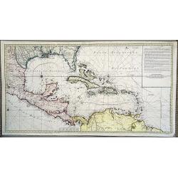
Carte d'une partie de l'Amérique pour la navigation des isles et du Golfe du Mexique.
A stunning and very scarce, highly detailed map of the Gulf of Mexico, Florida, Central America and the Caribbean from JA Dezauche, the successor to Buache and De L'Isle....
Date: Paris, 1780
Selling price: ????
Please login to see price!
Sold in 2020
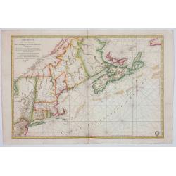
Carte Réduite Des Côtes Orientales De L' Amérique Septentrionale Contenant Celles des provinces de New-York et de la Nouvelle Angleterre..
A well engraved and highly detailed chart that was issued in Neptune americo-septentrionale. Showing the East Coast from Chaleur Bay to New Jersey, encompassing all of Ne...
Date: Paris, 1780
Selling price: ????
Please login to see price!
Sold in 2020

Planisphaerium Coeleste. Verlegt von I.M.Probst.
Scarce and very handsome celestial chart showing the constellations in allegorical form. Published by the lesser known brother Johann Michael Probst.Tucked between the cu...
Date: Augsburg 1780
Selling price: ????
Please login to see price!
Sold
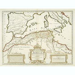
In notitiam ecclesiasticam Africae..
An engraved map of the Northern Africa coast, and the Mediterranean with good detail on the islands of Sardinia, Corsica, Majorca, Minorca, etc. Embellished with an uncol...
Date: Paris, 1780
Selling price: ????
Please login to see price!
Sold
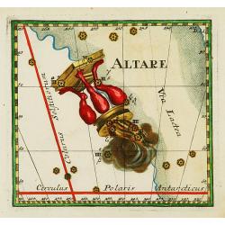
Altare
Uncommon celestial print showing the constellation of Altar, engraved by Johann Christoph Berndt and published by Johann Philipp Andreae (1700-1757).Published in the 'Mer...
Date: Nuremberg c.1780
Selling price: ????
Please login to see price!
Sold
![[Title page] Recueil Des Principaux Plans des Ports et Rades de la Mer Méditerranée, Estraits de ma carte en Douze Feüilles Dediée à Mons. Le Duc de Choiseul Ministre de la guerre et de la Marine ..](/uploads/cache/17242-250x250.jpg)
[Title page] Recueil Des Principaux Plans des Ports et Rades de la Mer Méditerranée, Estraits de ma carte en Douze Feüilles Dediée à Mons. Le Duc de Choiseul Ministre de la guerre et de la Marine ..
Title page from a famous chart book by Jean-Louis Jacquier-Roux, here one of the later editions published in Italy by Pre Meucci.
Date: Livourne, c.1780
Selling price: ????
Please login to see price!
Sold in 2009
Theatrum Historicum.. Romani tu Barbarorum.. Pars Occidentalis..
Showing the Roman Empire by G. de l'Isle, French cartographer, pupil of Cassini, called Father of Modern Geography. In upper left hand corner the Western hemisphere. Engr...
Date: Paris, 1780
Selling price: ????
Please login to see price!
Sold in 2008
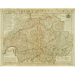
Carte de Suisse ou sont les Cantos de ..
General map of Switzerland with all the cantons good detail. In upper part 24 coats of arms of the different cantons.
Date: Paris, 1780
Selling price: ????
Please login to see price!
Sold in 2014

Pontis D. Jobi super Canalem Regium extensi eiusq vicinic Prospectus.
Decorative and dramatic engraved print of a bridge in Venice. Published by Domenico Lovisa (c.1690-c.1750), and engraved by Sipion Feramosca.
Date: Venice 1780
Selling price: ????
Please login to see price!
Sold
Partie du Nord de L'Amerique Septentrionale..
Rigobert Bonne (1727-1795), a prolific French cartographer, flourished between about 1760 and 1778, working in the French Hydrographical Office, and appointed as Hydrogra...
Date: Paris 1780
Selling price: ????
Please login to see price!
Sold

Cour des Lions dans le Palais..a Granada.
In the eighteenth and nineteenth centuries there were many popular speciality establishments in Paris, Augsburg and London which produced optical viewing devices and spec...
Date: Italy / France 1780
Selling price: ????
Please login to see price!
Sold
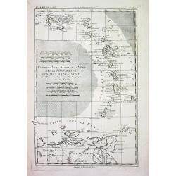
CARTE DES ISLES ANTILLES ou du VENT AVEC LA PARTIE ORIENTALE DES ISLES SOUS LE VENT
Beautiful and detailed copper-engraved map the lesser Antilles, from Puerto Rico to the coast of Venezuela. The map bears seven distance scales. From "Atlas de toute...
Date: Paris, c1780
Selling price: ????
Please login to see price!
Sold
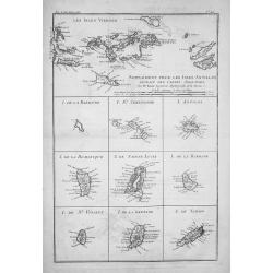
SUPPLÉMENT POUR LES ISLES ANTILLES, EXTRAIT DES CARTES ANGLOISES...
Beautiful and detailed copper-engraved map with excellent detail on the Virgin Islands + 9 inset maps of: Barbuda, St. Kitts, Antigua, Dominica, St. Lucia, Barbados, St. ...
Date: Paris, c1780
Selling price: ????
Please login to see price!
Sold
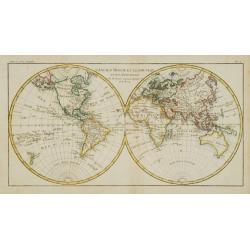
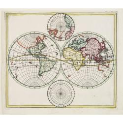
L'Ancien Monde et le Nouveau.
A bold border and decorative title cartouche enclose this map of the world. The double hemisphere includes the peninsular of California, a filled-in Northwest coast of No...
Date: Paris 1780
Selling price: ????
Please login to see price!
Sold
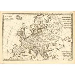
L' Europe
Rigobert Bonne (1727-1795), French cartographer. His maps are found in a.o. Atlas Moderne (1762), Raynal's Histoire Philos. du Commerce des Indes (1774) and Atlas Encyclo...
Date: Paris, c. 1780
Selling price: ????
Please login to see price!
Sold
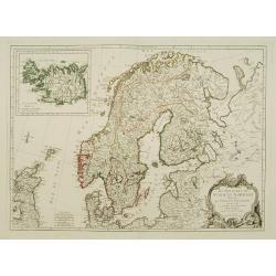
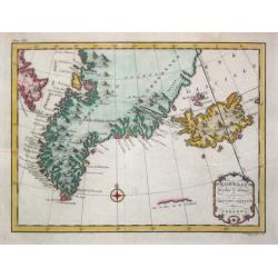
Les Royaumes de Suede et Norwege divisés par Provinces..
Detailed map of Scandinavia, with inset of Iceland. The author is M. Janvier.
Date: Venise, ca. 1780
Selling price: ????
Please login to see price!
Sold
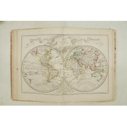
Atlas Géographique des quatre parties du monde par Guillaume de L'Isle et Phil. Buache.
Incomplete atlas published by Ph.Buache. Including engraved title, world map in double hemispheres, Europe, Plan topo-Hydrographique du Detroit de Gibraltar (by Treutel &...
Date: Paris 1780
Selling price: ????
Please login to see price!
Sold
Mappa Paraquariae in multis a me correcta. . .
A rare map of Paraguay from Dobrizhoffer Martin (1717-1791) Historia de Avipones y Mocobies. Engraved by F.Assner.The map includes all of Argentina from 11º to 370º sou...
Date: Vienna, 1780
Selling price: ????
Please login to see price!
Sold in 2011
Ceremonie de la grande Feste que les Chinois celebre le 24 de la Lune d'Aoust dans la principale Place de Pekin.
An optical view of festivities on the 24th of August in Bejing.
Date: Paris, c. 1780
Selling price: ????
Please login to see price!
Sold
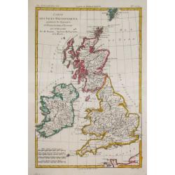
Carte des Isles Britanniques.
Rigobert Bonne (1727-1795), French cartographer. His maps are found in a.o. Atlas Moderne (1762), Raynal's Histoire Philos. du Commerce des Indes (1774) and Atlas Encyclo...
Date: Paris, c. 1780
Selling price: ????
Please login to see price!
Sold in 2018
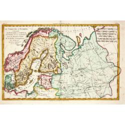
Le Nord de l'Europe.
Rigobert Bonne (1727-1795), French cartographer. His maps are found in a.o. Atlas Moderne (1762), Raynal's Histoire Philos. du Commerce des Indes (1774) and Atlas Encyclo...
Date: Paris, c. 1780
Selling price: ????
Please login to see price!
Sold in 2009
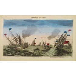
Tempête sur Mer.
So-called optical print. Showing a English and French ships at rough sea. Mondhare was one of the well-known publishers of optical prints, established in Paris.In the eig...
Date: Paris, 1780
Selling price: ????
Please login to see price!
Sold in 2022
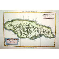
Kaart van het Eiland Jamaika.
An uncommon and very attractive map of Jamaica. The island's mountains are boldly engraved and excellent detail of the various river systems is provided. The parishes are...
Date: Amsterdam, c. 1780
Selling price: ????
Please login to see price!
Sold
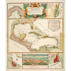
Mappa Geographica..Indiae Occidentalis..
Six varying sized insets depict the West Indies: Panama, Saint Augustine, Vera Cruz, Santo Domingo, and, a birds-eye view of Mexico City. The primary, largest inset map h...
Date: Nuremberg, 1780
Selling price: ????
Please login to see price!
Sold
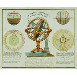
La Sphère Artificielle ou Armilaire Oblique.
Decorative copper plate showing armillary Sphere, two spheres according to Copernicus and Ptolemy and two diagrams.Sphere on a decorative stand.
Date: Paris c. 1780
Selling price: ????
Please login to see price!
Sold
World map.
Elaborately engraved double hemisphere map, showing California as an island. Taken from the rare Atlas methodicus explorandis juvenum profectibus in studio geographico ad...
Date: Nuremberg, 1780
Selling price: ????
Please login to see price!
Sold in 2016
Poland Corrected & Improve'd from the best authorities..
Uncommon map of Poland, prepared by John Barber, and engraved for and published in William Guthrie's new Geographical Grammer.With typical 18th century title cartouche lo...
Date: London 1780
Selling price: ????
Please login to see price!
Sold
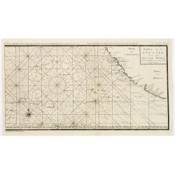
Riviere Tamise et Baye Mercure à la Nle. Zelande ..
A detailed chart after Cook?s charting of Mercury Bay and the Hauraki Bay at Auckland, New Zealand with soundings anchorages and other navigational data, with two insets ...
Date: Germany, c. 1780
Selling price: ????
Please login to see price!
Sold

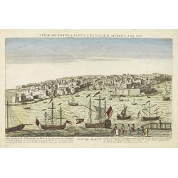
Vue du Port et de la Ville de L'Amekk dans Larbie..
So called optical print of Mekka. In lower part of the print the title: Vue du Port et de la Ville de L'Amekk dans Larbie heureuse a 5 lieues de la Mar Rouge .Rare.In the...
Date: Paris, ca 1780
Selling price: ????
Please login to see price!
Sold
Delineatio Pagi Tigurini ex observationibus recentissimis et accuratissimis : accedit seorsim in tabella dominum Sax et Forsteck.
Detailed map centered on Zurich. With very fine cartouches, upper right 36 coats of arms of cities in the region.Engraved by Tobias C. Lotter.
Date: Augsburg 1780
Selling price: ????
Please login to see price!
Sold in 2023
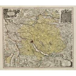
Pagi Basileensis qui pars est reipublicae Helvetiorum..
Detailed map of Basle Canton, centred on Basel and Rheinfelden.With fine title cartouche with panoramic view of Basel and heraldic figures like Neptune's, Mercury, Justit...
Date: Augsburg, 1780
Selling price: ????
Please login to see price!
Sold in 2022

J.Anckerstöm a killer of King Gustave III.
Decorative aquatint engraving after Witterquits.
Date: Augsburg 1780
Selling price: ????
Please login to see price!
Sold
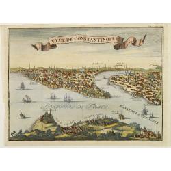
Veue de Constantinople.
Naïve panoramic view of Istanbul.
Date: Paris 1780
Selling price: ????
Please login to see price!
Sold
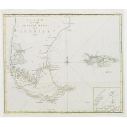
Kaart van het Zuidlyk Eind van Amerika. 1775.
Uncommon chart of the tip of South America, showing Patagonia, Tierra del Fuego and the Falkland Islands. With an inset of Staaten Land in the lower right corner.Publishe...
Date: Amsterdam c. 1780
Selling price: ????
Please login to see price!
Sold
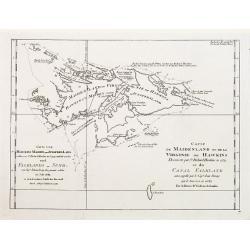
Carte de Maidenland ou de la Virginie de Hawkins.. Et du Canal Falkland..
Fine chart of the Falkland Islands called Maidenland or Virginie by Sir Richard Hawkins who discovered the islands in 1574.Also shows the Canal Falkland, the Strait betwe...
Date: Paris 1780
Selling price: ????
Please login to see price!
Sold
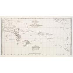
Charte von einem Theile des Süd-Meeres..
Map of the southern Pacific Ocean with Australia, New Zealand, and South America.
Date: Berlin 1780
Selling price: ????
Please login to see price!
Sold
Karte von der Süd-See oder dem Stillen Meere..
The right hand sheet of a 2-sheet map of the Pacific. Depicting Mexico and California, most northern name is Punta de los Reyes, most southern is Acapulco, including Bay ...
Date: Paris, 1780
Selling price: ????
Please login to see price!
Sold in 2016
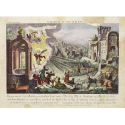
Vue de la Ville Bethlehem. . .
So-called optical print of the city Bethlehem in Israel, showing an angel announcing the birth of Jesus Christ. One of the well-known and earliest publishers of optical p...
Date: Paris, 1780
Selling price: ????
Please login to see price!
Sold in 2014
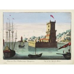
Prospectus Turris Bethlemi prope Ulyssipponem - Vue de la Tour de Bellem.
Optical view of the Belém Tower located in the Belém district of Lisbon, Portugal.In the eighteenth and nineteenth centuries there were many popular speciality establis...
Date: Italy 1780
Selling price: ????
Please login to see price!
Sold
Groenland.
Date: Amsterdam, 1780
Selling price: ????
Please login to see price!
Sold
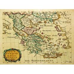
Carte de la Grece dressée sur un grand nombre de memoires..
Detailed copper-engraved map of Greece with its neighboring countries, including southern Italy and part of Cyprus. Relief shown pictorially. With large decorative title ...
Date: Paris, 1780
Selling price: ????
Please login to see price!
Sold in 2009
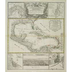
Mappa Geographica.. Indiae Occidentalis..
Six varying sized insets depict the West Indies: Panama, Saint Augustine, Vera Cruz, Santo Domingo, and a birds-eye view of Mexico City. The primary, largest inset map ha...
Date: Nuremberg, 1780
Selling price: ????
Please login to see price!
Sold in 2012
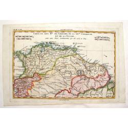
Carte du Nouvelle Royaume de Grenade, de Andalousie et de la Guyane.
Copper engraved for "Atlas de Toutes les Parties Connues du Globe Terrestre". From Panama to the mouth of the Amazon. BONNE, RIGOBERT (1729-1795). Bonne was �...
Date: Paris, 1780
Selling price: ????
Please login to see price!
Sold in 2013
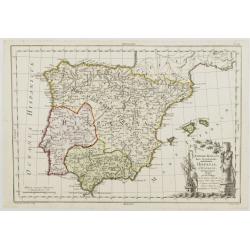
Imperii Romani Pars Occidentalis. Hispania. L'Espagne..
Detailed map of the Hibernian Peninsula and Baleares islands, showing also southwestern part of France.Decorative title cartouche in the lower right corner.
Date: Paris, ca 1780
Selling price: ????
Please login to see price!
Sold
Partie de Turquie en Europe.
Nicolas Sanson (1600-67), ' father of the French cartography' and founder of the Sanson firm. Atlas ' Cartes générales de toutes les parties du Monde', 1658-70 and a po...
Date: Paris, c. 1780
Selling price: ????
Please login to see price!
Sold
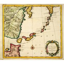
Carte des Isles Kouriles.
An attractive and unusual map of the Kuriles Islands and the northern coast of Hokkaido. The map includes numerous inaccuracies and fanciful names for a number of the isl...
Date: Amsterdam, 1780
Selling price: ????
Please login to see price!
Sold in 2011
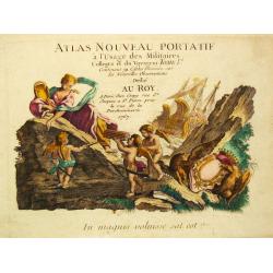
Atlas nouveau Portatif a l' Usage des Militaires Colleges et du Voyageur, Tome Ier.
Nice title-page of a French pocket-atlas.
Date: Paris, 1780
Selling price: ????
Please login to see price!
Sold
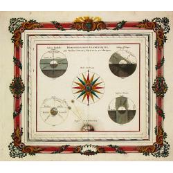
Demonstrations Geometriques, des Spheres Droite, Paralelle, et Oblique.
Louis Brion de la Tour (1756-1823), ' Atlas Géneral, Civil et Ecclésiastique', 1766, ' Atlas Général', 1790-98. Louis Charles Desnos (fl.1750-70).A celestial print fr...
Date: Paris, ca. 1780
Selling price: ????
Please login to see price!
Sold in 2013
![VUE DE MALTE. [View of Malta -Valetta].](/uploads/cache/24719-250x250.jpg)
VUE DE MALTE. [View of Malta -Valetta].
A so-called optical print. A very decorative and extremely rare view of Valetta, seen from the sea. The mirror-image title in top reads :Vue de la partie sud est de la vi...
Date: Paris, 1780
Selling price: ????
Please login to see price!
Sold in 2008
Vue de la ville de Batavia.
A so-called optical print showing a bird's eye view of Batavia, Java (now Djakarta, Indonesia), the headquarters of the V.O.C. in Indonesia. In the foreground many Dutch ...
Date: Paris, 1780
Selling price: ????
Please login to see price!
Sold in 2009
Vue perpective de l'Isle de St.Helene appartenant a la Compagnie Angloise pour les Indes Orientales.
Decorative optical view of St.Helena with in foreground British ships. The island is well-known as after Napoleon Bonaparte was captured by the Royal Navy, he was held ho...
Date: Paris, 1780
Selling price: ????
Please login to see price!
Sold in 2008
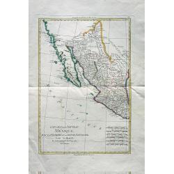
L'Ancien et le Nouveau Mexique avec la Floride et la Basse Louisiane. Partie Occidentale.
Excellent early map of California, Texas, Arizona, New Mexico, and Mexico. Very detailed with many towns, jesuit missions, forts, Indian areas, etc. Early geography of in...
Date: Paris, c 1780
Selling price: ????
Please login to see price!
Sold in 2010
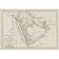
Carte de L'Arabie, rédigée en grande partie d'après le voyge récent et les Cartes de M. Niebuhr par le Sr. Brion de la Tour. . .
Giving good detail of the Arabian peninsula. From "Histoire Universel" by Louis Brion de la Tour.
Date: Paris, 1780
Selling price: ????
Please login to see price!
Sold
Vue de Malte.
Uncommon optical print of the harbour viewof Valletta on Malta. Text in French. Basset was a well-known publisher of optical prints, established in Paris, rue St.Jacques....
Date: Paris, 1780
Selling price: ????
Please login to see price!
Sold in 2013
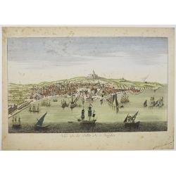
Vue de la ville de Naples.
A so-called optical print showing a panoramic view of Naples with a busy harbour.More about optical prints.
Date: Paris, c. 1780
Selling price: ????
Please login to see price!
Sold in 2016
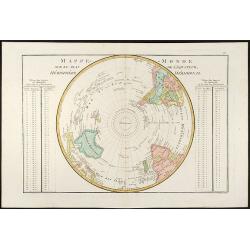
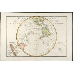
Mappe-Monde Sur Le Plan De L\'Equateur HémisphÞre Méridional
Beautiful colored map of the southern hemisphere by Rigobert Bonne.
Date: Paris, 1780
Selling price: ????
Please login to see price!
Sold in 2009
Mappe-Monde sur un Plan Horizontal, situé Ó 45d de latitude Sud. Hemisphire Occidental
Beautiful colored map of the Southwestern Hemisphere by Rigobert Bonne.
Date: Paris, 1780
Selling price: ????
Please login to see price!
Sold in 2009
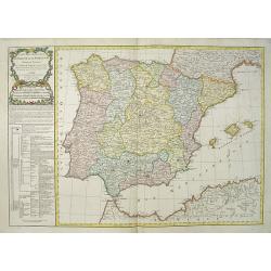
Carte des Royaumes d' Espagne et de Portugal divisés par . . .
A detailed map of Spain and Portugal. Embellished with an attractive title-cartouche. Published by Charles François Delamarche (1740-1817), a Paris-based geographer and ...
Date: Paris, 1780
Selling price: ????
Please login to see price!
Sold in 2016
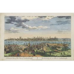
A General View of the City of Constantinople / Vue Générale de la Ville de Constantinople.
A panoramic view of Constantinople. Printed for F. West 83 Fleet Street, London.
Date: London, c.1780
Selling price: ????
Please login to see price!
Sold in 2009
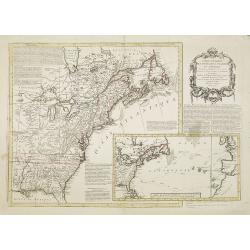
Carte Nouvelle des Posséssions Angloises en Amérique. . .
Third state, of this rare and attractive map shows Eastern Canada and the American colonies. It is important as it gives a clear notion of the international intrigues and...
Date: Paris, Moithey et Crepy, 1780
Selling price: ????
Please login to see price!
Sold in 2018
Carte de l'Amérique Méridionale, pour l'Histoire Générale des Voyages in 8º.
A nice map of South-America.
Date: Paris, 1780
Selling price: ????
Please login to see price!
Sold in 2010
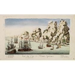
Vue du Cap de Bonne Esperance.
A fanciful, but rare optical print of the Cape of Good Hope". Published by Louis-Joseph Mondhare, who was a well-known publisher of optical prints, established from ...
Date: Paris, 1780
Selling price: ????
Please login to see price!
Sold in 2009
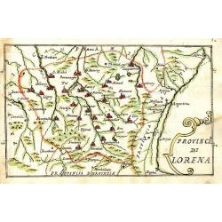
Provincia di Lorena.
Scarce manuscript map of the Lorraine region. Includes the cities of Metz, Verdun, Nancy,... Finely executed and detailed map by an Italian hand, showing the cities repre...
Date: 1740-1780
Selling price: ????
Please login to see price!
Sold in 2009
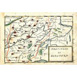
Provincia di Borgogna.
Rare manuscript map of the French border to Switzerland. Centered on Besancon, including the Lake de Geneva in Switzerland. Finely executed and detailed map by an Italia...
Date: c. 1740-1780
Selling price: ????
Please login to see price!
Sold in 2013

Gezicht van het West-Indisch-Huys, op de binnen plaats.
Inside-square of the West Indian Company headquarters at Amsterdam.Several traders are shown.Taken from his "Afbeeldingen van de wyd-vermaarde koopstad Amsterdam&quo...
Date: Amsterdam, 1780
Selling price: ????
Please login to see price!
Sold in 2016
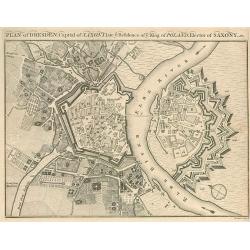
Plan of Dresden, Capital of Saxony.
Small plan of Dresden.
Date: 1780
Selling price: ????
Please login to see price!
Sold in 2010
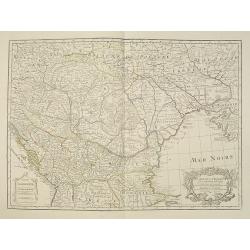
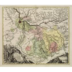
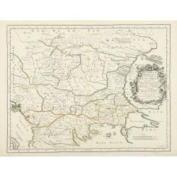
Carte de la Hongrie et Partie Septentrionale de la Turquie. . .
Showing the region between the Gulf of Venice and Croatia to the Black Sea, including Bulgaria, Romania, Macedonia, Ukraine, Hungary, and part of Poland and Bohemia.Decor...
Date: Paris, 1780
Selling price: ????
Please login to see price!
Sold in 2023
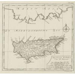
Het eiland cyprus door R.Pococke.
Rare map of Cyprus from a Dutch edition of ""Description Of The East And Some Other Countries" by R. Pococke. "Beschryving van het Oosten enz. Door de...
Date: Amsterdam/ Rotterdam, 1780
Selling price: ????
Please login to see price!
Sold in 2010
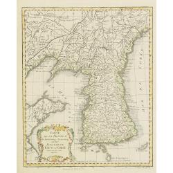
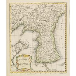
Carte de la Province de Quantong ou Lyau-tong et du Royaume de Kau-Li ou Corée . . .
Map of Korea. The language on the map is Dutch and French. The notation at the bottom indicates that the prime meridian is set at Ferro Island, otherwise known as El Hier...
Date: Paris, 1780
Selling price: ????
Please login to see price!
Sold in 2010
Montlouis.
Montlouis (Languedoc-Roussillon).
Date: Paris, ca. 1780
Selling price: ????
Please login to see price!
Sold in 2011

Monument de Mausoli batis par Arthemise mis au nombre d'une des 7 merveille du Monde.
Optical print from the series of 7 engravings "Seven wonders of the ancient world". Showing the Temple of Artemis at Ephesus.Located in Bodrum, about 50 km sout...
Date: Paris, 1780
Selling price: ????
Please login to see price!
Sold in 2013

Vue du superbe Temple de Ste Sophie aujourd'huy Mosquée principale à Constantinople.
A fanciful depiction of the Aya Sofya in Istanbul. In the eighteenth and nineteenth centuries there were many popular specialty establishments in Paris, Augsburg and Lond...
Date: Paris, 1780
Selling price: ????
Please login to see price!
Sold in 2013
Carte du Kamtchakta. . .
An early detailed map of the Kamchatka peninsula, based on the work of Stepan Petrovich Krasheninnikov, who travelled in the area 1737-41.Drawn and engraved by Laurent fo...
Date: Paris, 1780
Selling price: ????
Please login to see price!
Sold in 2010
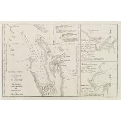
Carte de la baie des chaleurs a la côte occidentale du golfe de St Laurent. . . / Plan du havre de Ristigouche.
A well engraved and highly detailed two-in-one chart of "la baie des chaleurs" in Canada along the St. Laurence.Prepared in 1724 by L'Hermite and edited by the ...
Date: Paris, 1780
Selling price: ????
Please login to see price!
Sold in 2010
Carte de la Province de Quantong ou Lyau-tong et du Royaume de Kau-Li ou Corée . . .
Map of Korea. The map is of interest for the use of East Sea, the sea between Korea and Japan, here called "Mer de Corée Meer von Korea." Decorative title car...
Date: Paris, 1780
Selling price: ????
Please login to see price!
Sold
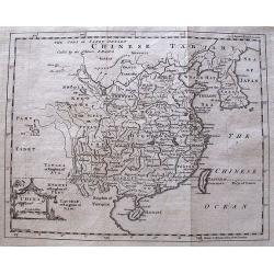
China.
Decorative map by the noted English cartographer Thomas Jeffreys, Geographer to George III and the Prince of Wales.
Date: London, c. 1780
Selling price: ????
Please login to see price!
Sold in 2012