Browse Listings
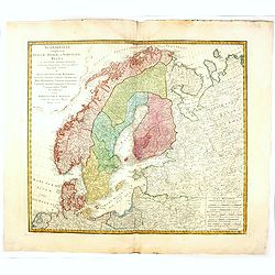
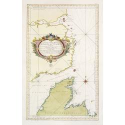
Scandinavia complectens sueciae, Daniae et Norvegiae. . .
A detailed map of Scandinavia covering Sweden, Denmark, and Norway. Published by the Homann Heirs.
Date: Nuremberg, 1776
Selling price: ????
Please login to see price!
Sold in 2019
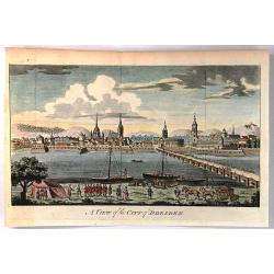
A view of the City of Dresden
Engraved city view looking across the river to Dresden. Military and commercial activities are shown on the near shore with many buildings on the far shore of the Elber R...
Date: London, 1776
Selling price: ????
Please login to see price!
Sold in 2016
![[Title page] Atlas Universel dressé sur les meilleures cartes modernes.](/uploads/cache/36722-250x250.jpg)
[Title page] Atlas Universel dressé sur les meilleures cartes modernes.
Title page of the Atlas Universel dressé sur les meilleures cartes modernes . Title is set in an allegorical scene of mythological figures.
Date: Venice, 1776
Selling price: ????
Please login to see price!
Sold in 2017
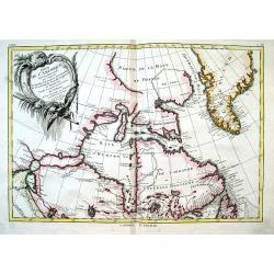
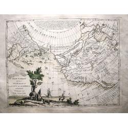
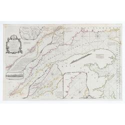
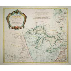
Partie de L'Amerique Septentrionale, qui comprend le Canada,...
Important map of the Hudson Bay and northeastern Canada from Lake Winnipeg to Greenland. It illustrates the French and English searches for the Northwest Passage. With se...
Date: Paris, 1776
Selling price: ????
Please login to see price!
Sold in 2016
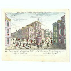
La Destruction de la Statue royale a Nouvelle Yorck.
A famous Revolutionary War optical prints, depicting the Sons of Liberty tearing down a statue of King Georg III at Bowling Green in New York.The image shows depict the e...
Date: Augsburg, 1776
Selling price: ????
Please login to see price!
Sold in 2016
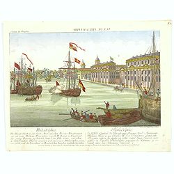
Vue de Philadelphie.
An attractive optical prints of Philadelphia, the capital of Pennsylvania, and the future fledgling nation's capital, during the Revolutionary war with Britain. A harbour...
Date: Augsburg, 1776
Selling price: ????
Please login to see price!
Sold in 2016
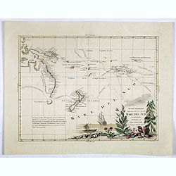
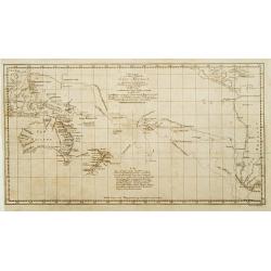
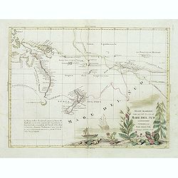
Nuove scoperte Fatte nel 1765. 67 e 69 nel Mare del Sud. . .
A very decorative map of the southern Pacific, showing the region from New Guinea to the Society Islands, marking the tracks of the explorers Carteret, Wallis, Byron and ...
Date: Venise, 1776
Selling price: ????
Please login to see price!
Sold in 2017
Nuove Scoperte De'Russi al Nord del Mare del Sud si nell'Asia, che nell'America.
A beautiful example of Antonio Zatta's map of the northern Pacific Coastal regions. One of the best illustrations of the Northwest Passage, here depicting two passages fr...
Date: Venice, 1776
Selling price: ????
Please login to see price!
Sold in 2017
![[Frontispiece] 'Atlas Universel Dresse sur les Meilleures Cartes Modernes.'](/uploads/cache/98688-250x250.jpg)
[Frontispiece] 'Atlas Universel Dresse sur les Meilleures Cartes Modernes.'
This is a very decorative frontispiece from Paolo Santini's atlas is a plagiat of Gilles Robert de Vaugondy's atlas published in 1757. On top Apollo steers his chariot dr...
Date: Venise, 1776
Selling price: ????
Please login to see price!
Sold in 2018

The Parricide. A Sketch of Modern Patriotism. Westminster Magazine, vol. IV, 1st May 1776.
Britannia attacked by America and the British lion.Reaction against ministers who supported the American cause. Images include: John Wilkes (1725-1797); America as a woma...
Date: London, 1776
Selling price: ????
Please login to see price!
Sold in 2018
Amerique Septentrionale avec les Routes, Distances en miles, Villages et Etablissements François et Anglois Par le Docteur Mitchel Traduit de l'Anglois ... Corigee en 1776 par M. Hawkins... Verbessert 1776
Second impression of third French edition of the famous John Mitchell map of the British and French Dominions in North America which was first published in 1755. Title in...
Date: Paris, 1776
Selling price: ????
Please login to see price!
Sold
![[Title page] Nouvelles vues perspectives des Ports de France, dessinées pour le Roi . . .](/uploads/cache/41603-250x250.jpg)
[Title page] Nouvelles vues perspectives des Ports de France, dessinées pour le Roi . . .
Title page of "Nouvelles vues perspectives des Ports de France".
Date: Paris, 1776
Selling price: ????
Please login to see price!
Sold in 2023
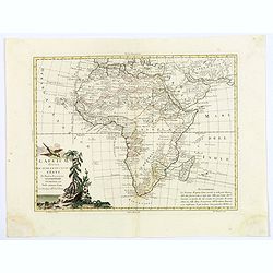
L'Africa divisa ne'suoi principali Stati di Nuova Projezione.
This attractive Italian map by Antonio Zatta is based on the earlier cartography of the Frenchman Janvier, and is quite accurate for the time period, although the source ...
Date: Venice, 1776
Selling price: ????
Please login to see price!
Sold in 2018
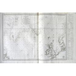
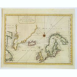
Carte Réduite des Mers du Nord . . .
A highly interesting large-scale sea chart of the North Atlantic. Extends from Labrador until Sweden. Shows the coasts of Scandinavia, the Baltic Sea, British Isles, Icel...
Date: Paris, 1776
Selling price: ????
Please login to see price!
Sold in 2018
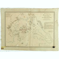
A Plan of Boston, and its Environs, shewing the true Situation of His Majesty's Army. And also those of the Rebels. Drawn by an Engineer at Boston. Octr. 1775.
An important plan of the Siege of Boston, based on a survey by a British officer present during the Siege, with details relating to fortifications, the disposition of for...
Date: London, 1776
Selling price: ????
Please login to see price!
Sold in 2018
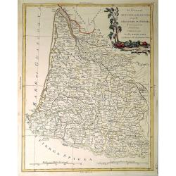
Li Governi di Guyenne e guascogna con quello de Bearn e Bassa Navarra. . .
A map of the Bordeaux region of France, including the cities of Bordeaux, Marmande, Tonneins, and Bayonne. To the south, the Navarra region of Spain along with the Pyrene...
Date: Venice, 1776
Selling price: ????
Please login to see price!
Sold in 2021
America meridionale divisa ne'fuoi principali Stati.
An attractive map depicting all of South America in the grand Zatta style. With a splendid ornate cartouche with Zatta's normal flourish. The map illustrates many of the ...
Date: Venice, 1776
Selling price: ????
Please login to see price!
Sold in 2021
Carte Nouvelle de l'Amerique Angloise Contenant tout ce que les Anglois Possedent sur le Continent de l'Amerique Septentrionale Savoir le Canada, la Nouvelle Ecosse ou Acadie, les Treize Provinces Unies...
This fine and large map was issued shortly before the outbreak of the American Revolution and was included in Lotter's Atlas Geographique. The map covers the region from ...
Date: Augsburg, 1776
Selling price: ????
Please login to see price!
Sold in 2019
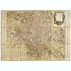
Plan routier de la Ville et Faubourg de Paris.
Grid plan. On both sides of the map, an alphabetical map of the streets Updates: North, opening of Thiroux Street, new name of St. Anne Street, which becomes rue Poissonn...
Date: Paris, 1776
Selling price: ????
Please login to see price!
Sold
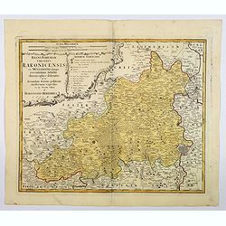
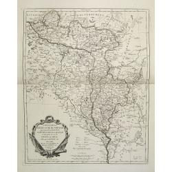
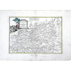
Regni Bohemiae Circulus Rakonicensis . .
A nice large-scale map of the Rakovnik region, north and west of Prague in the Czech republic. Published by Homann Heirs in the mid-eighteenth century in Nuremberg. From ...
Date: Nuremburg, 1776
Selling price: ????
Please login to see price!
Sold in 2021
Carte Reduite des Mers du Nord. . .
A scarce example of this attractive chart of the north Atlantic, including, Scandinavia, Iceland, Greenland, parts of Canada &c., from Prevost's 'Histoire Generale de...
Date: Amsterdam, 1776
Selling price: ????
Please login to see price!
Sold in 2019
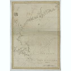
The Coast of New England.
A chart of New England Coast, taken from the "Atlantic Neptune", and marked in lower left corner "Published according to Act of Parliament April 24th, 1776...
Date: London, 1776
Selling price: ????
Please login to see price!
Sold in 2019
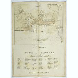
A plan of the Town of Newport in the province of Rhode Island.
A plan of the Town of Newport in the province of Rhode Island, taken from the "Atlantic Neptune", and marked in lower left corner "Published according to A...
Date: London, 1776
Selling price: ????
Please login to see price!
Sold in 2019
![[ Narraganset Bay and Rhodes Island and Harbour. ]](/uploads/cache/44824-250x250.jpg)
[ Narraganset Bay and Rhodes Island and Harbour. ]
A chart of Narraganset Bay and part of Rhode Island, taken from the "Atlantic Neptune", and marked in lower left corner "Published according to Act of Parl...
Date: London, 1776
Selling price: ????
Please login to see price!
Sold in 2019
![[Nantucket Island and the west end of Martha's Vineyard]](/uploads/cache/44826-250x250.jpg)
[Nantucket Island and the west end of Martha's Vineyard]
A chart of Nantucket Island, taken from the "Atlantic Neptune", and marked in lower left corner "Published according to Act of Parliament June 1st, 1776 by...
Date: London, 1776
Selling price: ????
Please login to see price!
Sold in 2019
![[ Buzzards Bay, Martha's Vineyard, Nantucket Island ]](/uploads/cache/44827-250x250.jpg)
[ Buzzards Bay, Martha's Vineyard, Nantucket Island ]
A chart of Buzzards Bay, Martha's Vineyard and Nantucket Island, taken from the "Atlantic Neptune", and marked in lower left corner "Published according to...
Date: London, 1776
Selling price: ????
Please login to see price!
Sold in 2019

Veduta della fonte e delle Spelonche d'Egeria fuor della porta Capena or di San Sebastiano... Tempio di Bacco, or di S. Urbano
View of the fountain and grotto of Egeria (Spelonche d'Egeria) outside the Porte Capena in Rome. An impressive and stark etching by the master of architectural prints Gia...
Date: Rome/Paris, 1776
Selling price: ????
Please login to see price!
Sold in 2020
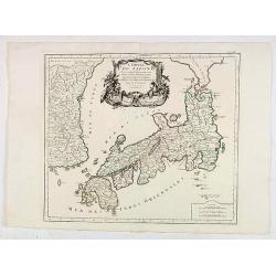
L'Empire Du Japon Divise En Sept Principales Parties..
Santini's Italian published edition of Giles Didier Robert De Vaugondy's map of Japan first appeared in 1778 in the "Atlas Universel".In 1784 Santini sold the p...
Date: Venice, 1776
Selling price: ????
Please login to see price!
Sold in 2020
Exact Chart of the River St. Laurence from Fort Frontenac to the Island of Anticosti showing the Soundings, Rocks, Shoals &c. with Views of the Lands and all necessary Instructions for navigating that River to Quebec.
2 sheets joined. 63 x 99 cm. Original outline color (none added).
Date: London, Robert Sayer. 1776
Selling price: ????
Please login to see price!
Sold in 2020

Anatra col collare dell'Isola di Terra Nuova.
A rare print of a Newfoundland duck, being plate DLXXV from the publication: 'Ornitologia methodice digesta atque iconibus aeneis ad vivum illumitatis ornata, latine et i...
Date: Florence, 1767-1776
Selling price: ????
Please login to see price!
Sold in 2020
CARTE DE L'ARCHIPEL AU NORD DE L'ISLE DE FRANCE. . . - REUNION,MAURITIUS,SEYCHELLES,DIEGO GARCIA.
A rare, large, and fine antique naval chart, depicting the Indian Ocean from as low as Mauritius to the southernmost Maldives islands, with an inset map of the Seychelles...
Date: Paris, 1776
Selling price: ????
Please login to see price!
Sold in 2021

Atlas universel dresse sur les meilleures cartes modernes.
An attractive uncolored example of the frontispiece to Paolo Santini's "Atlas Universel". The page is surmounted by Apollo being drawn in his chariot by four wh...
Date: Venice, 1776
Selling price: ????
Please login to see price!
Sold in 2022
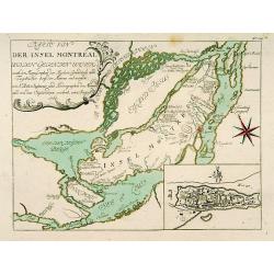
Karte von der Insel Montreal..
A rare issue of a plan of Montreal prepared by N.Bellin in 1760. The second state with the added plan of Montreal in lower right corner.
Date: Nurnberg, 1776
Selling price: ????
Please login to see price!
Sold in 2011
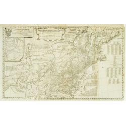
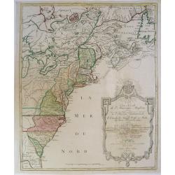
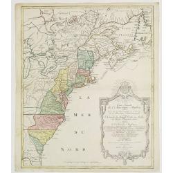
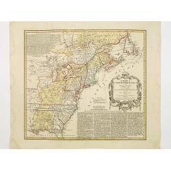
A map of the middle British colonies in North America.
A separately published copper engraving in one sheet. The map shows geography from the mouth of the Delaware to the eastern edge of New York; inland, it shows the Susqueh...
Date: London, 1776
Selling price: ????
Please login to see price!
Sold

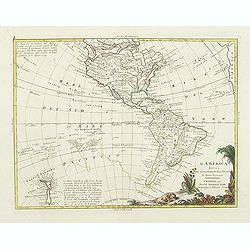
America meridionale divisa ne'fuoi principali..
Attractive map depicting all of South America in the grand Zatta style. Splendid ornate cartouche with Zatta's normal flourish. The map illustrates many of the primitive ...
Date: Venice 1776
Selling price: ????
Please login to see price!
Sold
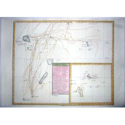
Charte von einem Theile des Süd=Meeres..
Showing the Pacific, with the track of the English vessel Delphin under Comodor Byron, and Tamar by Captain Mouat, in 1765. The Delphin by Captain Wallis and the Swallow ...
Date: Berlin 1776
Selling price: ????
Please login to see price!
Sold
Carte de la Pologne Autrichienne Contenant La Russie Rouge et la partie méridionale du Palatinat de Cracovie..
Detailed map of Poland, showing the area east of Krakow until Ukraine.Santini gives credit to Homann Heirs in the cartouche.
Date: Venise 1776
Selling price: ????
Please login to see price!
Sold
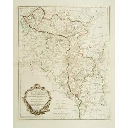
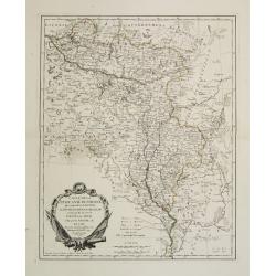
Carte de la Lithuanie Russienne qui comprend les Palatinats de Livonie de Witepsk, de Miscislaw..
Detailed map of Belarus, Latvia with the river Dnepr. Included are towns as Smolensk, Orsa, Minsk, etc.Santini gives credit to Homann Heirs in the cartouche. °
Date: Venise 1776
Selling price: ????
Please login to see price!
Sold
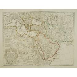
Carte de la Turquie de L\'Arabie et de la Perse.
Fine map of the Turkish Empire. A re-issue by Ph.Buache.
Date: Paris 1776
Selling price: ????
Please login to see price!
Sold in 2010
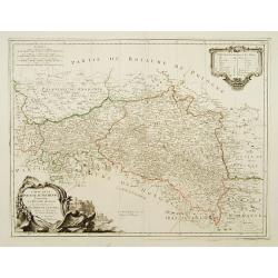
Carte de la Pologne Autrichienne contenant La Russie Rouge et la partie méridionale du Palatinat de Cracovie ..
Detailed map with Krakow, including the areas of Malopolskie and Podkarpackie and including present-day Ukraine.Santini gives credit to Homann Heirs in the cartouche. Mal...
Date: Venise, 1776
Selling price: ????
Please login to see price!
Sold in 2008
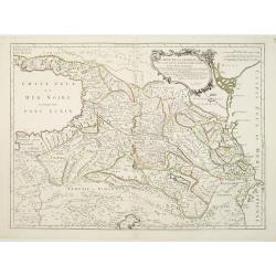
Carte de la Géorgie &c. des pays situés entre la Mer Noire et la Mer Caspienne..
Detailed map of Georgia, Armenia and Azerbaijan.Santini gives credit to Homann Heirs in the cartouche.
Date: Venise 1776
Selling price: ????
Please login to see price!
Sold
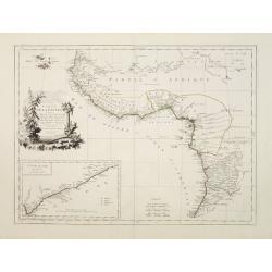
Carte de la Guinée contenant les Isles du Cap Verd le Senegal, la Côtede Guinée proprement dite les Royaumes de Loango, Congo..
Detailed map of Southwest African coast, from Guinea to Congo.Santini gives credit to R.Bonne in the cartouche. With inset map of the "Gold Coast" after d'Anvil...
Date: Venise 1776
Selling price: ????
Please login to see price!
Sold
Carte de la Lithuanie Russienne qui comprend les Palatinats de Livonie, de Witepsk, de Miscislaw, et un partie de ceux de Polock et de Minsk..
Detailed map of the areas along the river Dnieper and Duna.Santini gives credit to Homann Heirs in the cartouche.
Date: Venise, 1776
Selling price: ????
Please login to see price!
Sold in 2012
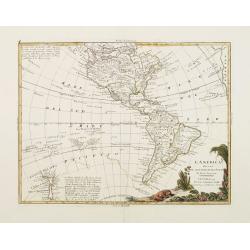
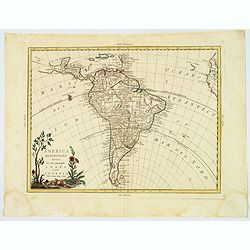
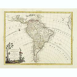
L'America divisa ne suoi principali Stati..
Attractive map of The Americas, with the first voyage of Capt. Cook (1768) depicted around South America and across the Pacific to New Zealand, which is well charted. Nor...
Date: Venice 1776
Selling price: ????
Please login to see price!
Sold

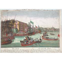
Débarquement des Troupes Angloises à Nouvelle Yorck.
So-called optical print which shows English troops landing in New York City during the Revolution prior to the conquest of the city. With reversed title in French along t...
Date: Paris, 1776
Selling price: ????
Please login to see price!
Sold in 2011
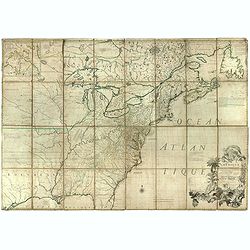
Carte Nouvelle de L'Amerique Angloise..
Large, beautiful and detailed map of the Eastern Seaboard, from Northern Florida to Newfoundland, including numerous Indian tribal lands and showing the British colonies ...
Date: Augsburg 1776
Selling price: ????
Please login to see price!
Sold
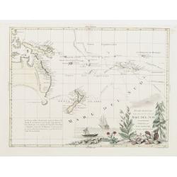
Nuove Scoperte Fatte nel 1765 . 67. e 69 nel Mare de Sud.
Antonio Zatta?s map of the South Pacific, showing the tracks of Cook's voyages through the region in 1765, 1767 and 1769. Shows Cook's tracks between New Zealand and alon...
Date: Venise 1776
Selling price: ????
Please login to see price!
Sold
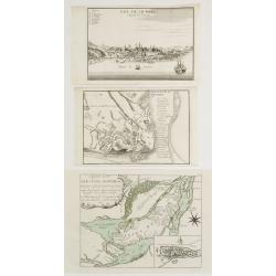
Plan de la Ville de Quebec / Vue De Quebec, Capitale du Canada / Karte von der Insel Montreal..
3 engravings illustrating plans and views of two cities belonging to the French speaking part of Canada.1 Detailed plan of the city of Quebec, uncolored. An uncommon issu...
Date: Paris / Nurnberg 1694-1776
Selling price: ????
Please login to see price!
Sold
Suite De La Carte Réduite Du Golphe De St. Laurent Contenant Les Costes de Labrador.. (1758
A well engraved and highly detailed chart that was issued in L'hydrographie françoise and is dated 1753. Seal of the Depot de Marine and prix trente Sols. The page numbe...
Date: Paris, 1776
Selling price: ????
Please login to see price!
Sold
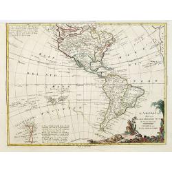
L'America divisa ne suoi principali Stati..
Attractive map of The Americas, with the first voyage of Capt. Cook (1768) depicted around South America and across the Pacific to New Zealand, which is well charted. Nor...
Date: Venice, 1776
Selling price: ????
Please login to see price!
Sold in 2017
Vuë de la Nouvelle Yorck. Neu Yorck. Eine Stadt in Nord-America auf einer Insul Manatthan.
Fascinating optical print with a view of the harbor in New York, showing an idealized image of Manhattan at the outbreak of the American Revolutionary-War.Read more about...
Date: Augsburg, 1776
Selling price: ????
Please login to see price!
Sold in 2023
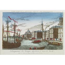
Le débarquement des troupes anglaises à New York.
The landing of the English troops in New York in September 1776. A so-called optical print. In the eighteenth and nineteenth centuries there were many popular speciality ...
Date: Paris, 1776
Selling price: ????
Please login to see price!
Sold
Carte de la Lithuanie Prussienne qui comprend les Palatinats de Livonie, de Witepsk, de Liscislaw, et une partie de ceux de Polock et de Minsk cédés par la Pologne à la Russie. Dressée sur l'Exemplaire des Héritiers Homann 1775.
Detailed map of the areas along the river Dnieper and Duna. Santini gives credit to Homann Heirs in the cartouche.The map was prepared by the Venetian cartographer and pu...
Date: Venice, 1776
Selling price: ????
Please login to see price!
Sold in 2009
Partie Occidentale du Canada et Septentrionale de la Louisiane..
Fine copper engraved map of the Great Lakes region after d'Anville's, to whom Santini gives credit in the cartouche.The map extends from the upper Mississippi River valle...
Date: Venice, 1776
Selling price: ????
Please login to see price!
Sold in 2009
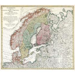
Scandinavia complectens Sveciae, Daniae et Norvegiae Regna ...
Scandinavia by Homann Heirs
Date: Nuremberg, 1776
Selling price: ????
Please login to see price!
Sold in 2009
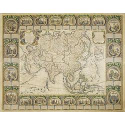
CARTE D'ASIE divisée EN SES PRINCIPAUX ETATS... Par Abbé Clouet. . .
Uncommon and decorative "carte à figures" wall map, prepared by Cloued, with superb decoration. The map is interesting as it shows Korea in the d'Anville type ...
Date: Paris, Mondhare, 1776
Selling price: ????
Please login to see price!
Sold
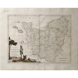
Li Governi di Guyenna e Guascogna con quello di Bearn e Bassa Navarra
Map of the Bourdeaux region of France, including the cities of Bourdeaux, Marmande, Tonneins, and Bayonne. To the south, the Navarra region of Spain along with the Pyrene...
Date: Venice, 1776
Selling price: ????
Please login to see price!
Sold in 2010
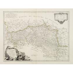
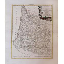
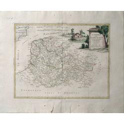
Li Governi del Limosin, Quercy, E Preigord Di Nuoca Projezione.
Map of the regions Limousin, Quercy and Périgord in southwest France different colors are used to outline the three regions and the titles in bold lettering further dist...
Date: Venice, 1776
Selling price: ????
Please login to see price!
Sold in 2010
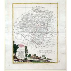
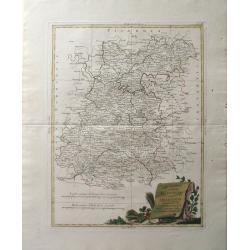
Li Governi del Berri, del Nivernois, della Marche, del Bourbonnois e dell \'Auvergne Di Nvoua Projezione.
Map of five regions in central France including the province Berry, most famous for the 14-15th century illuminated manuscript, "Les Trés Riches Heures du Dec de Be...
Date: Venice, 1776
Selling price: ????
Please login to see price!
Sold in 2010
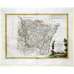
Li Governi Di Lorenza, Barr, ed Alsazia Di Nuova Projecione.
Map of three regions in northeastern France: Barrois, Lorraine and Alsace. Barrois is a "pays" and in the Middle Ages the region was a part of the duchy of Bar....
Date: Venice, 1776
Selling price: ????
Please login to see price!
Sold in 2010
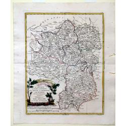
Li Governi dell\'Isola Di Francia ED Orleanois Di Nuova Projezione.
Map of the region surrounding Orleans France by Antonio Zatta. Map includes major cites such as Chartres, Fontainebleau and Beauvais and rivers systems. A bold cartouche ...
Date: Venice, 1776
Selling price: ????
Please login to see price!
Sold in 2010
Li Governi della Fiandra Francese, d\'Artois, di Picardia, del Boulonois di Nuova Projezione.
Map of Northern France by Antonio Zatta. This wonderfully detailed composition includes major cites such as Calais, Abbeville, and Dunkirk, and the northern coastline of ...
Date: Venice, 1776
Selling price: ????
Please login to see price!
Sold in 2010
Li Governi di Normandia del Maine e Perche di Nuova Projezione.
Map of the Normandy Coast of France by Antonio Zatta. This detailed map depicts major cities such as Rouen, Ambriere and Mortagne, and the off coast islands of Jersey, Gu...
Date: Venice, 1776
Selling price: ????
Please login to see price!
Sold in 2010
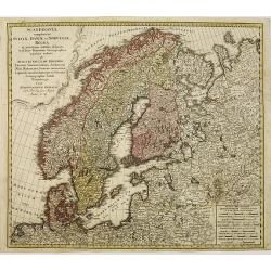
Scandinavia complectens sueciae, Daniae et Norvegiae. . .
Detailed map of Scandinavia, covering Sweden, Denmark, and Norway. Published by the Homann Heirs.
Date: Nuremberg, 1776
Selling price: ????
Please login to see price!
Sold in 2011
L'Estremadura e la Castiglia Nuova Di Nuova Projezione. . .
Map of the regions of Castille and Estremadura regions of west/central Spain by Antonio Zatta. The cities of Madrid and Toledo are depicted, as is the western border of P...
Date: Venice, 1776
Selling price: ????
Please login to see price!
Sold in 2010
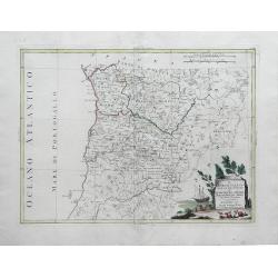
Il Portogallo Cioe le Provincie di Entredouro, e Minho, Traz-os-Montes, e Beira Di Nuova Projezione. . .
Map of the provinces of Minho, Biera, Tras-os-Montes e Alto Duoro and Beira, of northern Portugal, by Antonio Zatta. Towns, villages, forests, mountains and rivers of the...
Date: Venice, 1776
Selling price: ????
Please login to see price!
Sold in 2010
America meridionale divisa ne'fuoi principali..
Attractive map depicting all of South America in the grand Zatta style. Splendid ornate cartouche with Zatta's normal flourish. The map illustrates many of the primitive ...
Date: Venice, 1776
Selling price: ????
Please login to see price!
Sold in 2011
L\'America divisa ne suoi principali Stati..
Attractive map of The Americas, with the first voyage of Capt. Cook (1768) depicted around South America and across the Pacific to New Zealand, which is well charted. Nor...
Date: Venice, 1776
Selling price: ????
Please login to see price!
Sold in 2011
![Plan de Constantinonple et du Bosphore de Thrace, D'après celui levé sur les lieux en 1776, par Mr. Kauffer.. [Map in manuscript]](/uploads/cache/17483-250x250.jpg)
Plan de Constantinonple et du Bosphore de Thrace, D'après celui levé sur les lieux en 1776, par Mr. Kauffer.. [Map in manuscript]
An interesting French manuscript map of the Bosphorus from the Marmara See till the Black Sea. The outlines of Stambol ou Constantinople, At-Meydan ou Hyppodrome, Grand S...
Date: France, later than 1776
Selling price: ????
Please login to see price!
Sold
Nuove scoperte Fatte nel 1765. 67 e 69 nel Mare del Sud. . .
A very decorative map of the southern Pacific, showing the region from New Guinea to the Society Islands, marking the tracks of the explorers Carteret, Wallis, Byron and ...
Date: Venise, 1776
Selling price: ????
Please login to see price!
Sold in 2011

A plan of the City and Environs of Philadelphia. . .
The Lotter edition of Scull & Heap's seminal Philadelphia map, which map was first issued in 1752.Holmes' grid plan for the city is shown, situated between the rivers...
Date: Augsburg, 1777
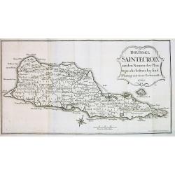
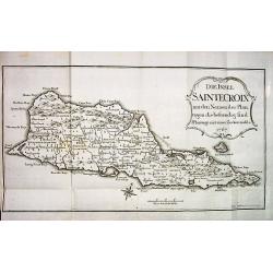
Die Insel SAINTE CROIX mit den Namen der Plan...
Very rare map of the Island of St. Croix (Santa Cruz), one of the US Virgin Islands. Although dated 1767 this it was published in 1777 in Oldendorp's "Geschichte der...
Date: Nuremberg, 1777
Selling price: ????
Please login to see price!
Sold
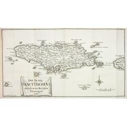
Die Insel Sanct Thomas mit den mehresten Plantagen 1767
Very rare map of the Island of St. Thomas, US Virgin Islands. Although dated 1767 this it was published in 1777 in Oldendorp's "Geschichte der Mission der evangelisc...
Date: Nuremberg, 1777
Selling price: ????
Please login to see price!
Sold
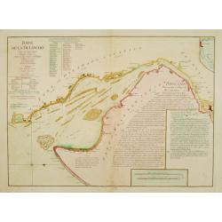
Baye de la Delaware.
Chart showing the Delaware Bay and port of Philadelphia, prepared by Joshua Fisher?s, re-issued by Le Rouge in Paris. North is oriented to the right. The sailing chart sh...
Date: Paris 1777
Selling price: ????
Please login to see price!
Sold
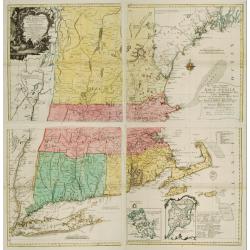
A map of the most inhabited part of NEW ENGLAND..
A separately published copper engraving in four sheets, 96.5 x 100cm. This is the second plate by Probst after the Jeffery's-Green map.With an imposing title cartouche up...
Date: Augsbourg, 1777
Selling price: ????
Please login to see price!
Sold
America Septentrionalis a Domino d'Anville..
The map is throughly annotated in German. Interesting map of the Colonies at the outset of the French & Indian War. Some of the interesting features include a truncat...
Date: Nuremberg 1777
Selling price: ????
Please login to see price!
Sold
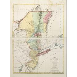
A map of the provinces of New-York and New-Jersey..
This map afforded British commanders during the Revolution an excellent overview of areas that would be crucial in the early years of the war, in particular the Hudson Va...
Date: Augsburg 1777
Selling price: ????
Please login to see price!
Sold
DIE INSEL SAINTE CROIX mit den Namen der Plantagen die bestaendig sind.
Very rare and sought after map of the Island of St. Croix (Santa Cruz), one of the US Virgin Islands. Although dated 1767 this it was published in 1777 in Oldendorp's &qu...
Date: Nuremberg, 1777
Selling price: ????
Please login to see price!
Sold
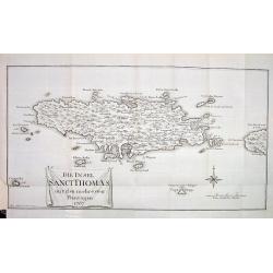
DIE INSEL SANCT THOMAS mit den mehresten Plantagen 1767
Very rare and sought after map of the Island of St. Thomas, US Virgin Islands. Although dated 1767 it was published in 1777 in Oldendorp's "Geschichte der Mission de...
Date: Nuremberg, 1777
Selling price: ????
Please login to see price!
Sold
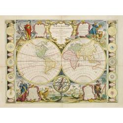
Mappe Monde Carte universelle de la Terre Dressée Sur les Re . . .
Prepared by J.B.Nolin. Decorative map of the world in two hemispheres surrounded by allegorical figures of the continents, armillary spheres and planetary systems at side...
Date: Paris, 1777
Selling price: ????
Please login to see price!
Sold in 2008