Browse Listings
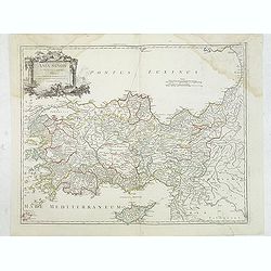
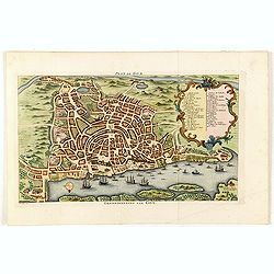
Asia Minor in suas partes seu provincias divisa. . .
Detailed map of Ancient Turkey with Cyprus from his "Atlas Universel".Gilles Robert de Vaugondy (1688–1766), also known as Le Sieur or Monsieur Robert, and hi...
Date: Paris, 1751
Selling price: ????
Please login to see price!
Sold in 2012
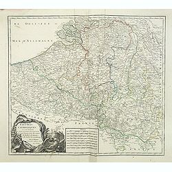
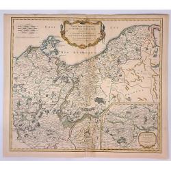
Pays-Bas Catholiques . . .
Detailled map of Belgium from his "Atlas Universel".Gilles Robert de Vaugondy (1688–1766), also known as Le Sieur or Monsieur Robert, and his son, Didier Robe...
Date: Paris, 1751
Selling price: ????
Please login to see price!
Sold in 2011
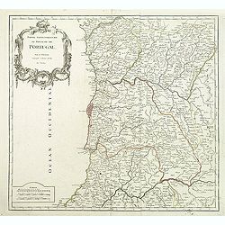
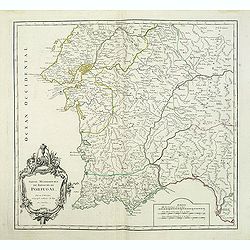
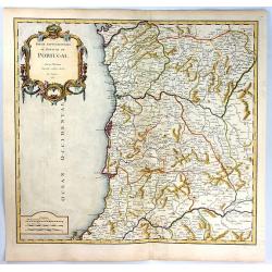
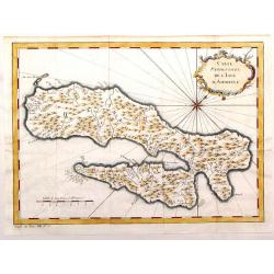
Partie Septentrionale du Royaume de Portugal.
Detailed map encompassing the whole northern half of Portugal from his "Atlas Universel".Gilles Robert de Vaugondy (1688–1766), also known as Le Sieur or Mons...
Date: Paris, 1751
Selling price: ????
Please login to see price!
Sold in 2011
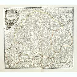
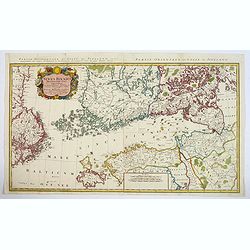
Le Royaume de Hongrie.
Detailed map of Hungary. Including kingdom of Croatia, Bosnia, Serbia and Bulgaria from his "Atlas Universel".Gilles Robert de Vaugondy (1688–1766), also know...
Date: Paris, 1751
Selling price: ????
Please login to see price!
Sold in 2020
Partie Meridionale du Royaume de Portugal.
Detailed map encompassing the whole southern half of Portugal from his "Atlas Universel".Gilles Robert de Vaugondy (1688–1766), also known as Le Sieur or Mons...
Date: Paris, 1751
Selling price: ????
Please login to see price!
Sold in 2011
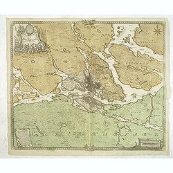
Charta öfwer Stockholms Stads Belägenhet.
A scarce town-plan of Stockholm. The map was engraved by Georg Biurmans himself and covers a large area around Stockholm including Drottningholm Palace in the west and in...
Date: Stockholm, c.1751
Selling price: ????
Please login to see price!
Sold in 2012
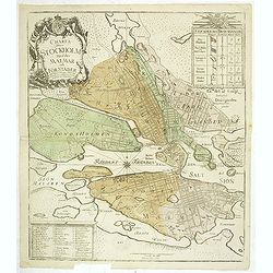
Charta öfwer Stockholm med des malmar och förstäder af Hans Konge Majt. til strandernes anlaggning i nader faststäld den 1. julii 1751.
A scarce town-plan of Stockholm. The map was engraved by Georg Biurmans himself and covers a large area around Stockholm. The major roads are carefully recorded. A large ...
Date: Stockholm, c.1751
Selling price: ????
Please login to see price!
Sold in 2012
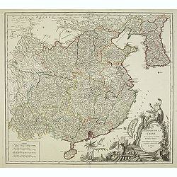
L'Empire de la Chine..
Detailed map of China, Korea and Taiwan. Decorative cartouche lower right showing natives.
Date: Paris, 1751
Selling price: ????
Please login to see price!
Sold in 2012
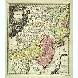
Pensylvania, Nova Jersey et Nova York..
Pre-Revolutionary War era map based on Lewis Evans’ map of 1749 and one of the few maps to concentrate on this area and one of the most bizarre maps of North America ev...
Date: Augsburg, c.1751
Selling price: ????
Please login to see price!
Sold in 2019
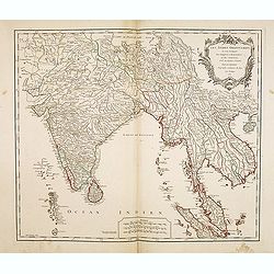
Les Indes Orientales, ou sount distingues les Empires et Royaumes..
Interesting regional map extending from India, the Ganges and the Maldive Islands to Hai-nan, Cochinchina, Malacca and Sumatra. Includes islands, "Sinca poura" ...
Date: Paris, 1751
Selling price: ????
Please login to see price!
Sold
Galliae Christianae Belgica Secunda Provinciae Ecclesiasticae Remensis
Nicely detailed copper engraved map covering the southwestern part of France. This map depicts the cities of Amiens, Senlis, Laon, Beauvais and Saint-Omer. Details includ...
Date: Paris, 1751
Selling price: ????
Please login to see price!
Sold in 2014
Galliae Christianae Belgicae Secundae Ecclesiasticae Provinciae Remensis
Very large, decorative title cartouche on an interesting Nolin map of Reims, Amiens & Senlis France. Engraved on copper plates by Dussy.J. B. Nolin 1657-1708)set up h...
Date: Paris, 1751
Selling price: ????
Please login to see price!
Sold in 2014
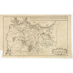
Carte generale des Villes et des Bailliages de la Prusse avec une partie de la Pologne et de la Vistule depuis Fantzig jusque à Warsovie.
Scarce map of northern part of Poland, including Gdansk and Warschaw. Engraved by Jacobus van der Schley (1715 - 1779).From "Memoires Pour Servir A L'Histoire De La ...
Date: The Hague, Berlin, Jean Neaulme, 1751
Selling price: ????
Please login to see price!
Sold in 2013
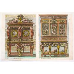
Hand colored Copper Engraving of Two Fancy Sideboards (Untitled).
Fine copper engraving of two very fancy sideboards. From "Oevres D'Architecture de Jean Le Pautre" published by Jobert. Jean le Pautre (1618 – 1682) was a F...
Date: Paris, 1751
Selling price: ????
Please login to see price!
Sold in 2015
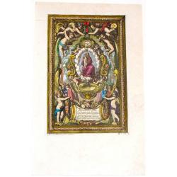
Madonna & Child.
Fine copper engraving of an ultra decorative "Madonna & Child" painting with engraved frame entitiled "Inventions for making Plates". From "O...
Date: Paris, 1751
Selling price: ????
Please login to see price!
Sold in 2014
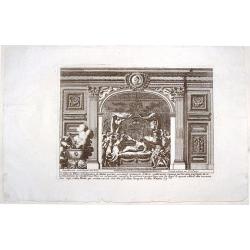
Les Filles de Pelias.
This fine copper engraving by Le Pautre features the daughters of Pelias turning on him and trying to kill him.From "Oeuvres d'Architecture de Jean Le Pautre" b...
Date: Paris, Mariette, 1751
Selling price: ????
Please login to see price!
Sold in 2015
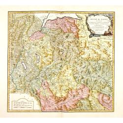
Duche de Savoye qui comprend le Chablais, le Fossigny, le Genevois, la Savoye Propre, la Tarentaise et la Maurienne, dresse d'apres la Grande Carte de Piemont de Tomaso Borgomo (i.e., Borgonio) et autres. . .
Finely and crisply engraved map of Savoy prepared by Robert de Vaugondy's map, from "Atlas Universel".Large decorative title cartouche in the upper right corner...
Date: Venice, ca.,1751
Selling price: ????
Please login to see price!
Sold
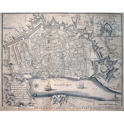
Antwerp A strong, large, and Beautiful City on ye River Scheld, in the Dutchy of Brabant, subject to ye Queen of Hungary / Plan of the City and Citadel of Antwerp
A large and very detailed plan of Antwerp with its forts. Shows numerous buildings and street names! Published in "Mr Tindal's Continuation of Mr Rapin's History of ...
Date: London, 1751
Selling price: ????
Please login to see price!
Sold in 2013
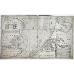
Nieuwe paskaart van het zuyderste gedeelte der Noord-Zee strekkende van Texel tot aande Hoofden...
Fine chart of the North Sea with the coasts of Belgium, Netherlands and South East England. Decorated with soundings, compass card, ship. Full title in a cartouche at bot...
Date: Amsterdam, 1728-1751
Selling price: ????
Please login to see price!
Sold in 2021
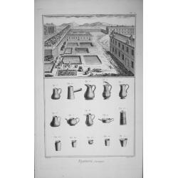
(Complete 15 Plate set) Fayancerie.
Complete 15 Plate set ‘Fayancerie’ Contenant Douze Planches Diderot's ‘Encyclopede du Duictionarnaire Raisonn des Sciences’. Original copper engraving drawn by L...
Date: Paris, 1751
Selling price: ????
Please login to see price!
Sold in 2014
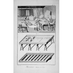
(Complete 9 Plate set) Miroitier Metteur au Teint.
Complete 9 Plate set ‘Miroitier Metteur au Teint’ ‘Encyclopede du Duictionarnaire Raisonn des Sciences’.Original copper engraving drawn by Lucotte & others, ...
Date: Paris, 1751
Selling price: ????
Please login to see price!
Sold in 2015

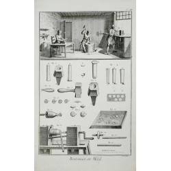
(Complete 5 Plate set) Chaudronnier.
Complete 5 Plate set Chaudronnier ‘Encyclopede du Duictionarnaire Raisonn des Sciences’.Original copper engraving drawn by Dasgerantins & others, engraved by Prev...
Date: Paris 1751
Selling price: ????
Please login to see price!
Sold in 2015

(Complete 9 Plate set of silk dryeing.) Teinturier.
Complete 9 Plate set ‘Teinturier’ from, Diderot's ‘Encyclopede du Duictionarnaire Raisonn des Sciences’ Edited by Denis Diderot. Original copper engraving drawn b...
Date: Paris, 1751
Selling price: ????
Please login to see price!
Sold in 2015

(A set of five plates about optical lens making.) Lunettier.
A set of five plates Lunettier (optical lens maker). From, Diderot's ‘Encyclopede du Duictionarnaire Raisonn des Sciences’.Edited by Denis Diderot.Collection of Plate...
Date: Paris, 1751
Selling price: ????
Please login to see price!
Sold in 2015
(A set of seven plates about button making in many forms) Boutonnier.
A set of seven plates ‘Boutonnier’ (Button making in many forms), from, Diderot's ‘Encyclopede du Duictionarnaire Raisonn des Sciences’. Edited by Denis Diderot. ...
Date: Paris 1751
Selling price: ????
Please login to see price!
Sold in 2016
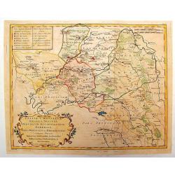
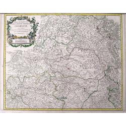
Cercle de Westphalie, divisé en tous ses etats et souverainetés.
Detailed map of the northwestern part of Germany, centered on M¨nster.
Date: Paris, 1751
Selling price: ????
Please login to see price!
Sold in 2014
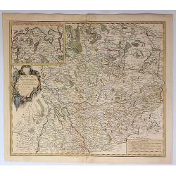
Partie méridionale du cercle de Haute Saxe. . .
Detailed map of part of Germany, centered on Leipzig.
Date: Paris, 1751
Selling price: ????
Please login to see price!
Sold in 2014
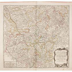
Partie méridionale du cercle de Haute Saxe. . .
Highly detailed regional map from De Vaugondy's Atlas Universel.
Date: Paris, 1751
Selling price: ????
Please login to see price!
Sold in 2014
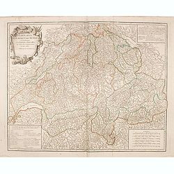
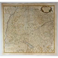
Carte de la République des Suisses. . .
Detailed map of Switzerland from De Vaugondy's Atlas Universel.
Date: Paris, 1751
Selling price: ????
Please login to see price!
Sold in 2014
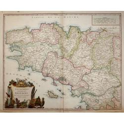
Gouvernement General de Bretagne divife dioceses ou recceptes.
An attractive map of Brittany that extends to the island of Belle-Île, just off of the Quiberon Peninsula. The map shows the divisions of the dioceses and is filled with...
Date: Paris, 1751
Selling price: ????
Please login to see price!
Sold in 2016
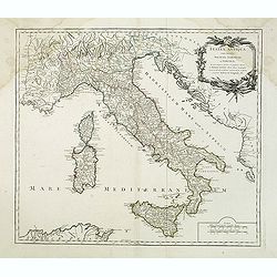
Italia antiqua cum insulius Sicilia, Sardinia et Corsica. . .
Map of Italy, including the islands of Corsica, Sardinia and Sicilia. Published by Robert Vaugondy (son 1723-1886) after a map by Nicolas Sanson. Map shows the ancient di...
Date: Paris, c.1751
Selling price: ????
Please login to see price!
Sold in 2014
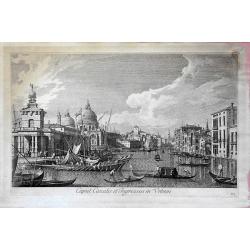
Caput Canalis et ingressus in urbem. . .
From "Urbis Venetiarum prospectus celebriores ex Antonii Canal tabulis XXXVIII. Aere expressi ab Antonio Visentini in partes tres distributi. Pars prima", this ...
Date: Venece, 1751
Selling price: ????
Please login to see price!
Sold in 2018
Nouvelle Carte de la Riviere de Canada ou St.Laurens de l'Isle de Anticoste jusqua Quebec. . .
A rare chart of the river St. Laurence with five insets. Including Montreal and Quebec.More about Van Keulen dynasty [+]
Date: Amsterdam, 1751
Selling price: ????
Please login to see price!
Sold in 2015
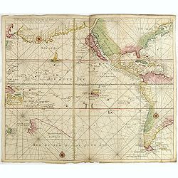
(Chart of the Pacific Ocean with California as an island)
A rare chart of the Pacific with California with an indented northern coast and the Strait of Anian to the north. There are lots of place names along the coasts of North ...
Date: Amsterdam, 1738 - 1751
Selling price: ????
Please login to see price!
Sold in 2015
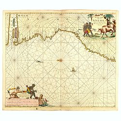
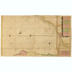
Pas caert vande cuften van Angola van Rio de Zaire...
This decorative sea chart of Angola features many place names along the coast. In the upper right corner, we see a figurative title cartouche, and in the lower left corn...
Date: Amsterdam, 1751
Selling price: ????
Please login to see price!
Sold in 2016
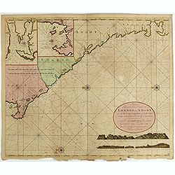
Nieuwe Paskaert van de Custen Zee Loango en Angoy van C. de Lopo Gonzalves tot R. de Zaire os Congo vertoonende alle desselfs gelegenteden.
Sea-chart of the coast of Gabon, Loango, Angoy and Angola to Zaire (Congo) River. In lower right side title and two coastal profiles. In upper left corner inset charts of...
Date: Amsterdam, ca. 1715 -1751
Selling price: ????
Please login to see price!
Sold in 2025
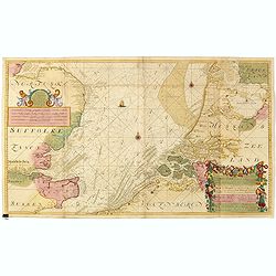
Nieuwe Generale Paskaart van de Bocht van Vrankryk Biscaia en Gallissia tussen I. de Ouessant en C. de Finisterre.
Rare chart of the Gulf of Biscay including all the south-west coast of France from Brest to the south and continuing along the Spanish coast, including Bilbao, until Ferr...
Date: Amsterdam, 1728-1751
Selling price: ????
Please login to see price!
Sold in 2015
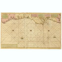
Nieuwe Generale Paskaart van de Cust van PORTUGAL tusschen C: de Finisterre. . .
Decorative chart of the coast of Portugal, from Pontevedra (Spain) to the Cape Saint Vincent (Vila do Bispo). East to the top. More about Van Keulen dynasty [+]
Date: Amsterdam, 1751
Selling price: ????
Please login to see price!
Sold in 2015
Nieuwe paskaart van het zuyderste gedeelte der Nord-Zee strekkende van Texel tot aande Hoofden...
Fine chart of the Nord Sea with the coasts of Belgium, Netherlands and South East England. Decorated with soundings, compass card, ship in a title cartouche in four langu...
Date: Amsterdam, 1728-1751
Selling price: ????
Please login to see price!
Sold in 2015
Nieuwe paskaart vande geheele canaal tufschen engeland en vranckryck.
This rare chart shows the Chanel between England et France. With explanation cartouche and ornamentally surrounded title-cartouche, fivefold miles indicator, current arro...
Date: Amsterdam, 1728 - 1751
Selling price: ????
Please login to see price!
Sold in 2016
Paskaart van de Cust van Portugal, Barbaria, en Genehoa. Beginnende van d' Barlenges tot aan C. Verde. Met al zyn Diepte en Drooghte dus ver Naaukeurig opgesocht door Ervaren Stuurlieden.
Fine sea chart of the Azores, Canary and Cape Verde island groups that were so important to the Atlantic trade routes. The large pictorial cartouche includes a group of E...
Date: Amsterdam, 1751
Selling price: ????
Please login to see price!
Sold in 2015
Nieuwe en zeer naauwkeurige paskaart van kusten van West Indien strekkende van Rio Oronoque tot beneede cartagena met alle de Caribische Eylanden. . .
Rare and beautiful sea chart by Van Keulen of the sea offshore of Venezuela and south of Hispanolia, the islands Trinidad, Margarita, Aruba and Curaçao are shown as well...
Date: Amsterdam, ca. 1728-1751
Selling price: ????
Please login to see price!
Sold in 2015
Nouvelle Carte de l'Etat de la Republique de Genes. Dressé sur les mémoires les plus nouveaux. . .
Uncommon map of the Ligurian coast around Genoa in northern Italy with three insets below of the harbors of Genoa and Bastia and the island of Corsica.Joachim Ottens (166...
Date: Amsterdam, 1751
Selling price: ????
Please login to see price!
Sold in 2016
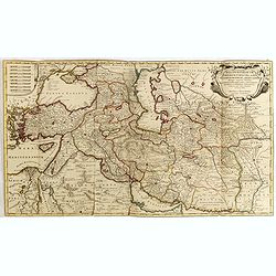
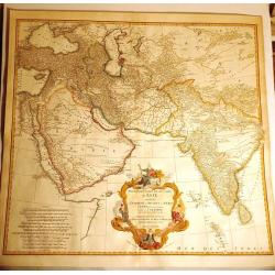
Regnum Persicum Imperium Turcicum in In Asia Russorum Provinciae ad Mare Caspium . . .
Striking map of the region bounded by Cyprus and the Eastern Mediterranean, the Nile, Medina, the Persian Gulf and the Indus River in the south and the Black Sea, Circass...
Date: Amsterdam, 1751
Selling price: ????
Please login to see price!
Sold in 2015
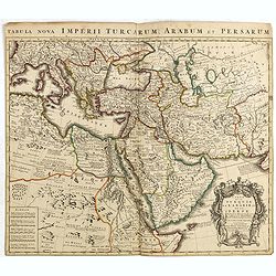
Carte de la Turquie de L'Arabie et de la Perse.
Rare early state of De L'Isle's map of the Turkish Empire and Arabian Peninsula. Includes the Turkish Empire, Mediterranean, Central Asia and parts of the Ukraine, Egypt,...
Date: Amsterdam, 1751
Selling price: ????
Please login to see price!
Sold in 2015
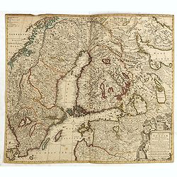
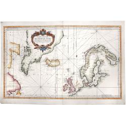
Regni Sueciae Tabula Generalis, divisa in Sueciae, Gotiae.
Fine map centered on Finland, including part of Sweden, Norway and Russia.The map was originally issued by Frederick de Wit but than re-issued by Pieter Mortier in Amster...
Date: Amsterdam, 1751
Selling price: ????
Please login to see price!
Sold in 2018
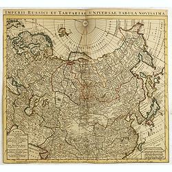
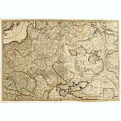
Kaert van Het geheele Russische Keizerryk...
Map of the whole Russian empire. Together with Major and Minor Tartary now enlarged with new discoveries in the year 1739 by captain Span(g)berg. Map extends from Scandin...
Date: Amsterdam, 1751
Selling price: ????
Please login to see price!
Sold in 2015
Sades Belli in POLONIA et in Moscovia . . .
Scarce map including Lithuania, Russia, Ukraine, Curlandia, Livonia, Tartaria Minor, Walachia, Volhynia, etc. With a key in lower bottom. Small inset map of Astrakan regi...
Date: Amsterdam, 1751
Selling price: ????
Please login to see price!
Sold in 2015
Le cercle de Baviere . . .
Interesting regional map, extending from Waldeck in the North to Efferding on the Danube in the East, Saltzberg and the Tyrolian Alps in the South and Dillingen on the Da...
Date: Paris, 1751
Selling price: ????
Please login to see price!
Sold in 2016
Premiere Partie de la Carte d'Asie Contenant la Turquie, l'Arabie, la Perse, l'Inde en deca du Gange et de la Tartarie
Magnificent 2-sheet map of the western half of Asia by D’Anville. Includes from Turkey through the Black and Caspian Seas to Tibet, and south to include the Arabian pen...
Date: Paris, 1751
Selling price: ????
Please login to see price!
Sold in 2015
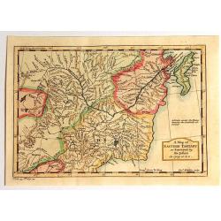
A Map of Eastern Tartary as Surveyed by the Jesuits in 1709, 1710 & 1711.
A fine map of Eastern Tartary that shows parts of present-day Russia, Mongolia, and China, and was based on the work of Jesuit cartographer Jean-Baptiste Regis.In the bot...
Date: London, 1751
Selling price: ????
Please login to see price!
Sold in 2015
AN ACCURATE MAP OF THE COUNTY OF KENT DIVIDED INTO ITS LATHES, and Subdivided into Hundreds. Drawn from Surveys, and most approved modern Maps, with various additional Improvements: Illustrated with Historical Extracts relative to the Air, Soil, Natural P
A first edition pre Large Atlas. A large and handsome eighteenth-century map of the county on a scale of three-eighths of an inch to the mile.Compiled by Emanuel Bowen, G...
Date: London, 1751
Selling price: ????
Please login to see price!
Sold in 2017
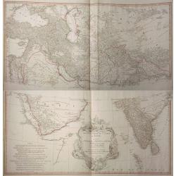
Premiere Partie de la Carte d´Asie Contenant la Turquie, l´Arabie, la Perse, l´Inde en deca du Gange et de la Tartarie.
A magnificent 2-sheet map of the western half of Asia by D’Anville. Includes from Turkey through the Black and Caspian Seas to Tibet, and south to include the Arabian p...
Date: Paris, 1751
Selling price: ????
Please login to see price!
Sold in 2017
Carte particuliere de la Cote Occidentale de l'Afrique...
A large 2 sheet map of a part of the west coast of Africa that covers The Gambia and Senegal.
Date: Paris, ca. 1751
Selling price: ????
Please login to see price!
Sold in 2016
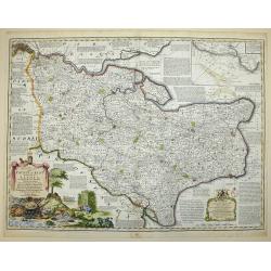
Partie septentrionale du Gouvernem? general de Champagne....
Very detailed map of the northern part of the famous Champagne region, centered on Reims. Includes towns, mountains, rivers, lakes, etc. With a large decorative title car...
Date: Paris, ca. 1751
Selling price: ????
Please login to see price!
Sold in 2016
Partie Septentrionale du Royaume de Portugal
A finely engraved map of the northern portion of Portugal by Robert de Vaugondy. It covers northern Portugal from Tui in Spain, southward to Santarem, and inland as far a...
Date: Paris, 1751
Selling price: ????
Please login to see price!
Sold in 2019
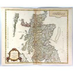
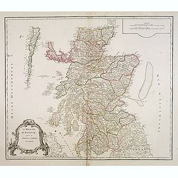
L'Ecosse Divisee en Shires ou Comtes
A decorative map of Scotland, published by Boudet in Paris in 1751. The map includes a decorative Rococo cartouche and scale of miles in the bottom left corner.The map is...
Date: Paris, 1751
Selling price: ????
Please login to see price!
Sold in 2023
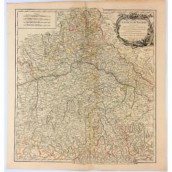
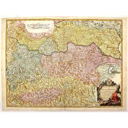
Le Cercle de Baviere Qui Comprend le Haut Palatinat, les Duchés de Haute et Basse Baviere et de Neuburg, L'Archevéché de Salzburg...
An interesting regional map, extending from Waldeck in the North to Efferding on the Danube in the East, Saltzberg and the Tyrolian Alps in the South, and Dillingen on th...
Date: Paris, 1751
Selling price: ????
Please login to see price!
Sold in 2017
Cercle de Souabe...
The Circle of Swabia, or Swabian Circle, was an Imperial Circle of the Holy Roman Empire established in 1500 on the territory of the former German stem-duchy of Swabia. T...
Date: Paris, 1751
Selling price: ????
Please login to see price!
Sold in 2018
Cercle de Westphalie Divise en Tout Ses Etats et Souverainetes.
A fine map of Westphalia by Vaugondy in 1751. The Lower Rhenish–Westphalian Circle was an Imperial Circle of the Holy Roman Empire. It comprised territories of the form...
Date: Paris, 1751
Selling price: ????
Please login to see price!
Sold in 2018
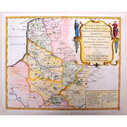
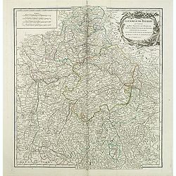
Partie Septentrionale du Cercle de Haute Saxe qui contient le Duche de Pomeranie et le Marquisat de Brandebourg...
A stunning map of the northern portion of Upper Saxony, in what is now northeast Germany and Northwest Poland. It includes the Duchy of Pomerania and Brandenburg, and ext...
Date: Paris, 1751
Selling price: ????
Please login to see price!
Sold in 2018
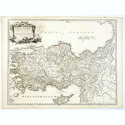
Asia Minor in suas partes seu provincias divisa. . .
A detailed map of Ancient Turkey with Cyprus from his "Atlas Universel". With s decorative title cartouche.Gilles Robert de Vaugondy (1688–1766), also known a...
Date: Paris 1751
Selling price: ????
Please login to see price!
Sold in 2019
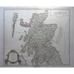
Le Royaume D'Ecosse divisee en Shires ou Comtes.
A striking and detailed map of Scotland, from Vaugondy's “Atlas Universel”. It includes towns, cities, mountains, rivers and lakes. Interestingly shaped rococo decor...
Date: Paris, 1751
Selling price: ????
Please login to see price!
Sold in 2018
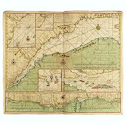
Sinus Finnici Delineatio Geographica ex quam pluriminis subsidiis novissimis stereographice tradita per Dm. Tobiam Majerum. . . Professorem . . .
A fine mid-18th century two sheet map of the Gulf of Finland with its surroundings (Åland, Southern Finland, Inkerinmaa, Estonia, Karjalankannas, Uppland). St. Petersbur...
Date: Nuremberg, 1751
Selling price: ????
Please login to see price!
Sold in 2018
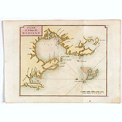
Plan de la Baye de Manille.
Detailed plan of Manila Bay after George Anson's key plan of the Bay of Manila. Several places are named along the coast, including Bataan, Metro Manila, and Cavite. With...
Date: Paris, 1751
Selling price: ????
Please login to see price!
Sold in 2018
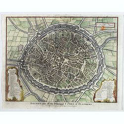
Bruges one of the Principal Cities of Flanders.
A birds-eye plan of the lovely Belgian city of Bruges, seen here within its ancient walls and fortifications. A number of bridges and windmills are shown, along with pict...
Date: London, ca 1751
Selling price: ????
Please login to see price!
Sold in 2019
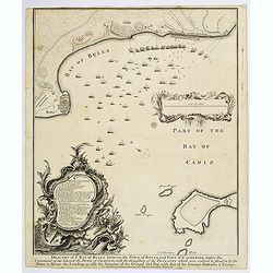
Draught of the Bay of Bulls between the Town of Rotta and Fort St. Catherine. . .
A large plan of the Bay of Bulls in southern Spain, outlining a military action fought by the English there, as part of the ongoing 'War of the Spanish Succession' - foug...
Date: London, ca 1751
Selling price: ????
Please login to see price!
Sold in 2020
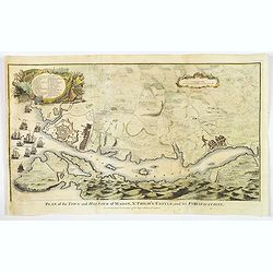
Plan of the Town and Harbour of mahon, St. Philip's Castle, and its Fortifications.
An attractive bird's-eye plan of Mahon and its fortifications and surrounds in the mid eighteenth century. You see the town plan of Mahon, the capitol of the Balearic isl...
Date: London, 1751
Selling price: ????
Please login to see price!
Sold in 2019
CARTE REDUITE DES MERS DU NORD. Pour serive aux Vaisseaux du Roy.
A large, striking hand-colored map of the North Sea, depicting the Scandinavia peninsula, the United Kingdom, Greenland, east coasts of today's US and Canada and centered...
Date: Paris, 1751
Selling price: ????
Please login to see price!
Sold in 2019
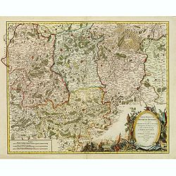
![Partie septentrionale du cercle de Haute Saxe [...] Brandebourg.](/uploads/cache/44152-250x250.jpg)
Partie septentrionale du cercle de Haute Saxe [...] Brandebourg.
Finely and crisply engraved map of north eastern part of Germany, including part of Poland. With inset map of Brandenburg. Map by Robert De Vaugondy with an ornamental ti...
Date: Paris, ca 1751
Selling price: ????
Please login to see price!
Sold in 2020
The Seraglio & Gardens of the Grand Seignior. / Serrail & Jardins du Grand Seigneur.
This rare plan of the Topkapi Palace in Istanbul was published by John Rocque, an English engraver, active in London from 1734. The title is printed in English and French...
Date: London, 1752
Selling price: ????
Please login to see price!
Sold
Le Royaume d'Ecosse.
Detailed map of Scotland, from a later edition of DeVaugondy's Atlas Universel. Includes towns, mountains, rivers, lakes and a host of other details. Decorative Cartouche...
Date: Paris, after 1752
Selling price: ????
Please login to see price!
Sold in 2014
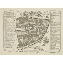
Plan de Goa. Grondtekening van Goa.
A beautifully detailed and engraved town-plan of the Portuguese colony of Goa in India, with a number key (1-29) to the city's major monuments and sites, enclosed in a de...
Date: Amsterdam, 1752
Selling price: ????
Please login to see price!
Sold in 2017
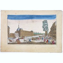
A view of the Exchange the South and North Blaak taken from the Gaapers Bridge ROTTERDAM - Vue de la Bourse. . .
So-called optical print. Fine panoramic view of the exchange of Rotterdam, with many people on the foreground.Underneath : "Published according to Act of Parliament&...
Date: London, after 1752
Selling price: ????
Please login to see price!
Sold in 2014
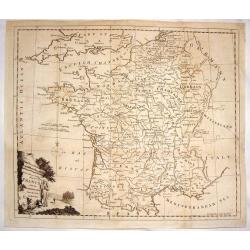
A New and Accurate Map of France with the Netherlands From the Best Authorities.
An interesting map featuring a rural cartouche with a woman holding a cross and looking at a papal crown and chalais laying on the ground. Emanuel Bowen (1714-1767), ma...
Date: London, 1752
Selling price: ????
Please login to see price!
Sold in 2015
Partie Meridion. du Duche de Brabant.
Detailed map of a part of Belgium from his "Atlas Universel".Gilles Robert de Vaugondy (1688–1766), also known as Le Sieur or Monsieur Robert, and his son, Di...
Date: Paris, 1752
Selling price: ????
Please login to see price!
Sold in 2014
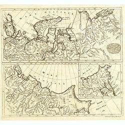
Sibirie maxime Septentrionalis pars a Nova Semlja in oceanum orientalem . . .
Scarce map of Siberia engraved by Johann Eberhard Alber, who was a German copper engraver active from 1742-1757.
Date: Nuremberg, 1752
Selling price: ????
Please login to see price!
Sold in 2014
Carte Particuliere de L'Isle d'Amboine.
Fine hand-colored,copper engraved map of Ambon in the Moluccas Islands (Spice Islands)off the coast of Indonesia. After N. Bellin and engraved by Van Schley.
Date: Paris, 1752
Selling price: ????
Please login to see price!
Sold in 2018
Partie Septentrionale du Cercle D'Autriche Qui Comprend L'Archiduche D'Autriche.
A pleasing map of North Austria centered around the Danube River which flows through the top part of the map through Vienna. Large title cartouche is featured in the righ...
Date: Paris, 1752
Selling price: ????
Please login to see price!
Sold in 2018
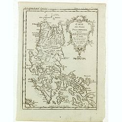
Carte des isles Philippines, dressée sur la carte espagnole du R.P. Murillo de Velarde. Ire feuille. . . 1752.
Fine map of the northern islands of the Philippines.Jacques Nicolas Bellin (1703-1772) was one of the most important and proficient French cartographers of the mid-eighte...
Date: Paris, 1752
Selling price: ????
Please login to see price!
Sold in 2021