Browse Listings
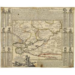
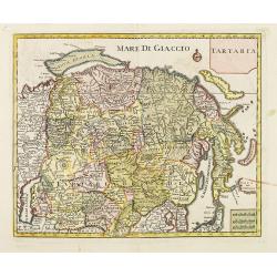
Tartaria Minor. . . . Calendarium Perpetuum oder Ein Immerwährender Kalender. . .
Very rare map of the Crimea and Ukraine, surrounded by a Calendarium Perpetuum. Each month is represented in a block with the the days and its Saint and topped with a dwa...
Date: Augsburg, 1740
Selling price: ????
Please login to see price!
Sold in 2025
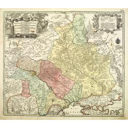
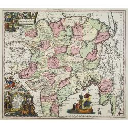
Amplissima Ucraniae Regio Palatinatus Kioviensem et Braclaviensem . . .
An uncommon and attractive map of the Ukraine has excellent detail of the river systems and charming, pictorial topography. It is decorated with two elegantly engraved ca...
Date: Augsburg, 1740
Selling price: ????
Please login to see price!
Sold in 2011
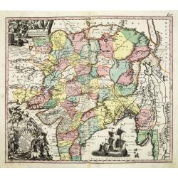
Imperii Magni Mogolis sive Indici Padschach. . .
Impressive map of the Mongol Empire, including present India (except the southern tip), Pakistan, Afghanistan, parts of Burma, etc.Decorated with two colored pictorial ca...
Date: Augsburg, ca 1740
Selling price: ????
Please login to see price!
Sold in 2011
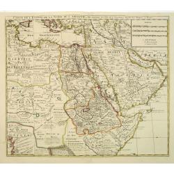
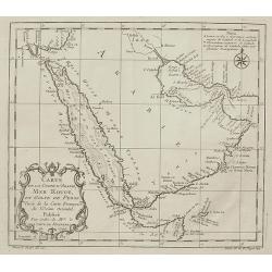
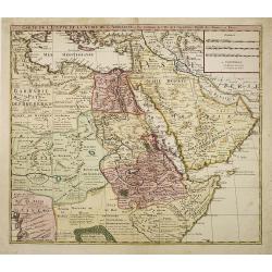
Carte de L\'Egypte de la Nubie de L\'Abissinie. . .
Prepared by G.de l'Isle. Uncommon issue by Hendrik de Leth. Very detailed map of northeastern Africa, the Red Sea and the Arabian peninsula shows the political divisions ...
Date: Amsterdam, 1740
Selling price: ????
Please login to see price!
Sold in 2012
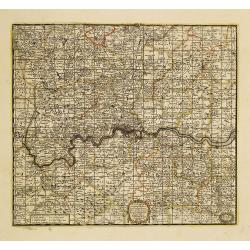
A New Map Containing the Towns Gentlemens Houses Villages and other Remarks Round London . . .
Detailed map showing hundreds of place names in the greater London area, including Darking, Hampsted, Hertford, Guildford, etc.
Date: London, 1740
Selling price: ????
Please login to see price!
Sold in 2011
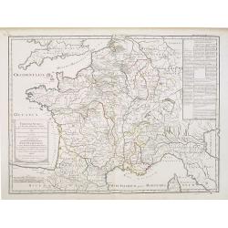
Franciae status sub regibus primae stirpis,. . ./ Etat de la France sous les rois de la première race. . .
A historical map of France depicting the region at the beginning of the Middle Ages. It depicts the kingdom of Clovis, the Founder of France, as it was divided among his ...
Date: Paris, 1740
Selling price: ????
Please login to see price!
Sold
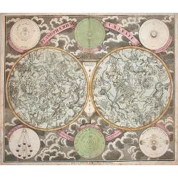
Planisphaerium Caeleste.
A very decorative double hemisphere celestial chart, centered on the North and South Poles.With circular diagrams illustrating the theories of Tycho, Ptolemy and Copernic...
Date: Augsburg, 1740
Selling price: ????
Please login to see price!
Sold in 2016
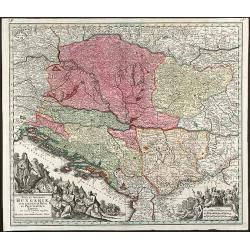
Nova et Accurata Hungariae cum adiacentib. Regn. et Principatibus Tabula
Original old colored map of the Balkan by M. Seutter. Showing Hungary, Serbia, Croatia, Bosnia and Herzegovina and Albania. With two beautiful cartouches.
Date: Augsburg, 1740
Selling price: ????
Please login to see price!
Sold in 2009
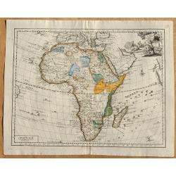
Carta Generale Dell' Africa.
From an Italian edition of "Atlante Novissimo". Published by Albrizzi. With a vignette cartouche in upper right showing a crocodile hunt.
Date: Venice, ca 1740
Selling price: ????
Please login to see price!
Sold in 2008
![[Title page] Le Nouveau Theatre du Monde.](/uploads/cache/25938-250x250.jpg)
[Title page] Le Nouveau Theatre du Monde.
A large and finely engraved frontispiece by F. Bleiswyk entitled "Le Nouveau Theatre du Monde" for Pieter van der AA. Shows Atlas carrying the world on his shou...
Date: Leiden, ca. 1740
Selling price: ????
Please login to see price!
Sold in 2021
![[Title page] Atlas Novus..](/uploads/cache/25950-250x250.jpg)
[Title page] Atlas Novus..
A very large title page featuring the people holding maps and a "Queen" sitting on a globe depicting Africa, Asia and Europe.
Date: Augsburg, ca. 1740
Selling price: ????
Please login to see price!
Sold in 2008
Carte particuliere de la Hungarie de la Transivanie de la Croatie et de la Sclavonie. . .
A map showing Hungary, Serbia, Croatia.
Date: Amsterdam, 1740
Selling price: ????
Please login to see price!
Sold in 2008
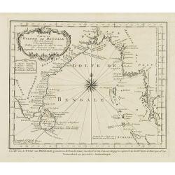
Carte du Golphe de Bengale. . .
Uncommon map of India, Ceylon and East coast of Malaysia, after J.N.Bellin. With title in Dutch in lower margin, engraved by J. van Schley. From Atlas Portatif pour serv...
Date: Amsterdam, 1740
Selling price: ????
Please login to see price!
Sold in 2011
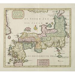
Het Koninkryk Japan, verdeelt in Acht en zestig Provintien in alle Naauwkeurigheid en Zorgvuldigheid Beschreven en uytgegeven Volgens de Oorspronkelyke Japansche Kaarten. . .
Map of Japan as well as two inset maps of Kamtschatka / Tschukotka and that Peninsula Oshima of Hokkaido. Title cartouche held by two Japanese Gods, Tossitoku and Nebis, ...
Date: Amsterdam, ca 1740
Selling price: ????
Please login to see price!
Sold in 2008
Carta Geografica del Regno di CORSICA.
Taken from In Lo stato presente di tutti i paesi, e popoli del Mondo ...Vol. XXIV, edited by Thomas Salmon. A Italian edition of this famous work, published in 26 volumes...
Date: Albizzi, Venise, 1740
Selling price: ????
Please login to see price!
Sold
Imperii Magni Mogolis sive Indici Padschach..
Impressive map of the Mongol Empire, including present India (except the southern tip), Pakistan, Afghanistan, parts of Burma, etc.Decorated with two colored pictorial ca...
Date: Augsburg, ca 1740
Selling price: ????
Please login to see price!
Sold in 2008
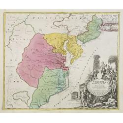
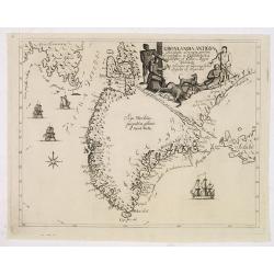
Virginia Marylandia et Carolina.
An attractive and detailed map, covering the coastline from Long Island in the north to just south of Cape Feare in Carolina, with the large fictitious Apalache Lacus in ...
Date: Augsburg, 1740
Selling price: ????
Please login to see price!
Sold
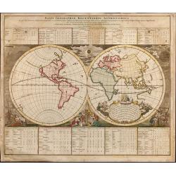
Basis Geographiae Recentioris Astronomica
Worldmap in double hemisphere. California as an Island. From the Doppelmayr \"Atlas Coelestis\" published by J.B. Homann in Nuremberg.
Date: Nuremberg, 1740
Selling price: ????
Please login to see price!
Sold in 2009
Carte de la Coste d'Arabie, Mer Rouge, et Golfe de Perse,...
Nice small map focusing on the Red Sea, also covering coastal areas around the Arabian Peninsula and the Persian Gulf. Jacques Bellin was Hydrographer in the French Dép�...
Date: Paris, 1740
Selling price: ????
Please login to see price!
Sold in 2009
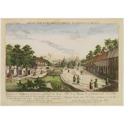
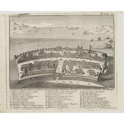
Vue de la Bastion de Gelderland, hors de la Ville Batavia.
Complete title : Vuë de la bastion de Gelderland hors de la ville Batavie [mirror-reversed] / Collection des Prospects / Prospect von der Bastion Gelderland ausserhalb d...
Date: Augsburg, 1740
Selling price: ????
Please login to see price!
Sold in 2010
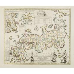
Nieuwe Kaart van 't Keizerrijk Japan.
Japan is still drawn in a nearly purely east-west position. At bottom right at the island of Fatsisio is mentioned: To this island the powerful men of Japan were sent Int...
Date: Amsterdam, 1740
Selling price: ????
Please login to see price!
Sold in 2009
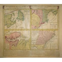
Dominia Anglorum in America Septentrionali.
Four maps on one sheet (New Foundland/ New England/ Virginia and Carolina/Florida) based on J.B.Homann\'s map, showing British possessions in North America. At bottom of ...
Date: Nuremberg 1740
Selling price: ????
Please login to see price!
Sold in 2009
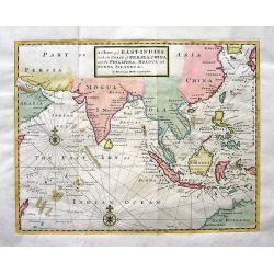
A Chart of ye EAST-INDIES, With the Coast of Persia, China also the Philipina, Moluca and Sunda Islands &c.
A very decorative chart of the Indian Ocean. The map extends until Saudi Arabia and Madagascar in the West, and Australia, New Guinea, and Japan in the East. Shows a part...
Date: London, c.1740
Selling price: ????
Please login to see price!
Sold in 2009
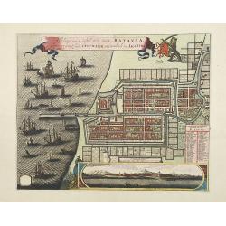
Afbeldinge van het casteel en de stadt Batavia. . .
Copied after Clement de Jonghe's map of 1650. Map of Jakarta, head quarters of the V.O.C.Joachim Ottens (1663 - 1719) and his sons Renier and Joshua were prominent Dutch ...
Date: Amsterdam, 1740
Selling price: ????
Please login to see price!
Sold in 2011
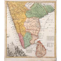
Peninsula Indiae Malabar Coromandel Ceylon.
Homann's family well-engraved map of southern India and Ceylon.
Date: Nuremberg, 1740
Selling price: ????
Please login to see price!
Sold in 2014
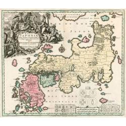
Regni Japoniae nova mappa geographica.
One of the most decorative and elegant maps of Japan. The map is based on Englebert Kaempfer's map of 1727. It shows a much distorted outline for the Island of Japan and ...
Date: Augsburg, 1740
Selling price: ????
Please login to see price!
Sold in 2010
Mappa Geographica complectens..
Decorative map depicting the region of Central America. View of Mexico.
Date: Nuremberg, 1740
Selling price: ????
Please login to see price!
Sold in 2009
Danubii Fluminis pars media in qua Hungaria, Sclavonia..
Very rare "carte à figures" map of former Yugoslavia. With decorative title cartouche and surrounded by four borders with 13 city views each accompanied by lar...
Date: Augsburg, 1740
Selling price: ????
Please login to see price!
Sold
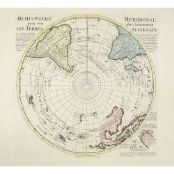
Hemisphere meridional pour voir plus distinctement les terres australes. . .
With the imprint of the Ottens family - rare. An Antarctic map including a recounting of the discovery of an island south of the Cape of Good Hope which was named Cap de ...
Date: Amsterdam, 1740
Selling price: ????
Please login to see price!
Sold in 2011
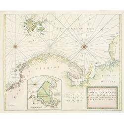
A New Generall Chart of Ye Northern Ocean vitz Norway, Greenland, Finmark, Lapland, Moscovy and Nova Zembla.
Chart of the coasts of Norway, Sweden, Lapland, Russia, including the west coast of Nova Zembla, and part of Greenland. With inset of the island of Podesemsko, with Archa...
Date: London, 1716 - 1740
Selling price: ????
Please login to see price!
Sold in 2009
Oran Munita Urbs et Comodus Porta in Ora Maritima Barbariae.
Map of the vicinity of Oran with panoramic view from the sea below.
Date: Augsburg, 1740
Selling price: ????
Please login to see price!
Sold in 2010
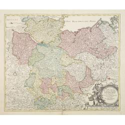
Circulus Saxoniae inferioris.
Johann Baptist Homann's well-engraved map of northern part of Germany. Including the towns of Hamburg, Berlin, Gottingen, enz. Johann Baptist Homann (1663-1724) was a Ger...
Date: Nuremberg 1740
Selling price: ????
Please login to see price!
Sold in 2022
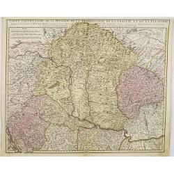
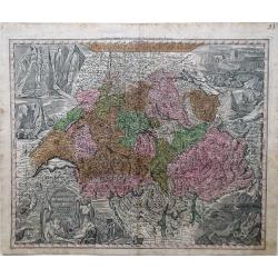
Nova Totius Helvetia cum Suis Surditis.
Matthaus Seutter map of Switzerland with vignettes of the Alps in the upper right and left corners and bottom right corner.
Date: Augsburg, 1730-1740
Selling price: ????
Please login to see price!
Sold in 2010
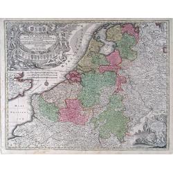
Germanie Inferioris Belgii.
Matthaus Seutter map of northern France, Belgium and Holland. Shows from Paris, France in the south to Rotterdam, Holland in the north.
Date: Augsburg, 1730-1740
Selling price: ????
Please login to see price!
Sold in 2010
XVII Provincia Belgii five Germanie Inferioris.
Matthaus Seutter map showing regions of northern France, Belgium, Holland, England and Germany.
Date: Augsburg, 1730-1740
Selling price: ????
Please login to see price!
Sold in 2010
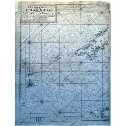
A Large Chart of The Channell Between England And France.
A striking nautical chart detailing of the channel between England and France.
Date: London, 1740
Selling price: ????
Please login to see price!
Sold in 2010
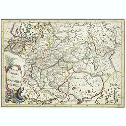
Post Charte des Russischen Reichs.
Rare map of Russia showing the postal roads. Large title cartouche in lower left corner.More about post road mapspost route maps.
Date: Germany, ca. 1740
Selling price: ????
Please login to see price!
Sold in 2010
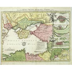
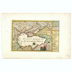
Des neueroffneten Kriegs-Theatri in Rusland und Turckey..
A rare map of the Black Sea, the scene of Russia-Turkish hostilities in 1736-9. The inset fortification plans feature Constantinople, Azov, Bendery and the strongholds at...
Date: Nuremberg 1740
Selling price: ????
Please login to see price!
Sold in 2010
Nova Totius Helvetia cum Suis Surditus ac Sociis.
Decorative map of Switzerland with vignettes of the Alps in the upper right and left corners and bottom right corner and a decorative cartouche in the lower left corner.
Date: Augsburg, 1730-1740
Selling price: ????
Please login to see price!
Sold in 2010
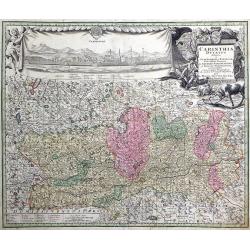
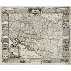
Carinthia Ducatus destineta in Superiorem, et Inferior. Cum infertis Dominiis ad Archiep Salisburgens et Episcop. Bambergensis pertinentibus nova mappa Geographica ob oculos et venum exposita per Matth. Seutter.
Decorative map of the region of the duchy of Carinthia in southern Austria bordering the eastern Alps. The map shows many details of the regions, such as mountains, abbey...
Date: Augsburg, 1730-1740
Selling price: ????
Please login to see price!
Sold in 2010
St. Sebastian. A strong fortified town of Guiapuscoa laying at the bottom of the Bay of Biscay
A very rare plan of San Sebastian in Spain by W.H. TomsThis copper engraved plan of San Sebastian was drawn by G. S. Baudwin and sold, engraved and published by W. H. Tom...
Date: London, 1740
Selling price: ????
Please login to see price!
Sold in 2010
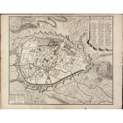
Plan de la ville de Brusselle, Ville Noble au Duche de Brabant, et les delices des Pays Bas.
Impressive and scarce plan of Brussels by Covens & Mortier. This city plan was engraved by F. De Bakker and published in Amsterdam after 1712. The plan is a copy of t...
Date: Amsterdam, 1740
Selling price: ????
Please login to see price!
Sold in 2010
Tartaria.
A fine map of Siberia, including Korea and Japan. From "Atlante Novissimo Che Contiene Tutte Le Parti Del Mondo...." This atlas was published in Venice and was ...
Date: Venice, 1740
Selling price: ????
Please login to see price!
Sold in 2012
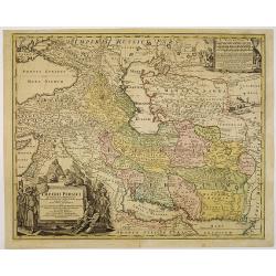
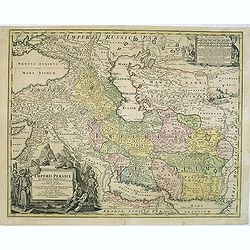
Imperii Persici in omnes suas Provincias . . . Exacte Divisi Nova Tabula Geographica. . .
Showing the eastern part of Turkey and Cyprus, Palestine, Persian Gulf, including Gulf of Oman, Caspian Sea, Iran and the north-west territories of India.Embellished with...
Date: Nurenberg, 1740
Selling price: ????
Please login to see price!
Sold in 2010
Carte de L'Egypte de la Nubie de L'Abissinie. . .
Prepared by G.de l'Isle. Uncommon issue by Hendrik de Leth. Very detailed map of northeastern Africa, the Red Sea and the Arabian peninsula shows the political divisions ...
Date: Amsterdam, 1740
Selling price: ????
Please login to see price!
Sold in 2010
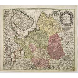
Mappae Imperii Moscovitici pars Septentrionalis.
Detailed map of northern Russia embellished with an uncolored pictorial cartouche showing hunting scenes.Good detail in Lapland, the White Sea and Archangel. St. Petersbu...
Date: Augsburg, 1740
Selling price: ????
Please login to see price!
Sold in 2010

Petr Welikij imperator i camoderschez wserossinskij oschez oschetscheschewa (rossice). Petrus Magnus totius Russiae imperator et autocrator.
Mezzo tint by A. Zouboff, after J. G. Tannauer. Very rare variant of the portrait of Peter the Great with a Cristal Czar cross and crown. Another version is known where t...
Date: St. Petersburg, c. 1740
Selling price: ????
Please login to see price!
Sold in 2014
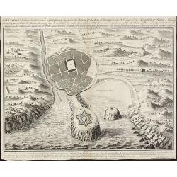
Accurater Grundriss und gegend des vestung Asoph samt der Russischen Belagerung.
A map of the Black Sea with in top a plan and siege of the town of Asoph, "Prospect und Belagerung der Vestung Asoph” and "Plan “Wahrer Grundriß der Vestun...
Date: Germany, c.1740
Selling price: ????
Please login to see price!
Sold in 2010
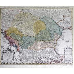
Carte d'Hongrie en general contenant felon la Division ancienne & methodique, la Hongrie en particulier, la Croatie, la Dalmatie, la Bosnie, la Servie, la Boulgarie; la Principaute de Transylvanie, les Defpotats de Walacie & de Moldav...
A fine map of the Balkan region, including Hungary, Romania, Bulgaria, Bosnia, Serbia, Macedonia and the eastern regions of the Black Sea, by Johann Matthias Haas (Hasius...
Date: Nuremberg: c.1740
Selling price: ????
Please login to see price!
Sold in 2010
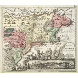
Recens edita totius Novi Belgii in America Septentrionali.
This most spectacular map, based on the Janssonius' map of the area. A wonderful cartouche adjacent to the title shows a long line of gods and natives bringing forth gift...
Date: Augsburg, 1730-1740
Selling price: ????
Please login to see price!
Sold in 2011
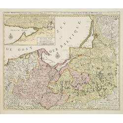
Regni Borussiae.. Royaume de Prusse. . .
Rare map of Prussia, with inset map of the area around Kaliningrad (Koningsberg), the capital of Kaliningrad region, and an exclave of White European Russia, on the Prego...
Date: Amsterdam, 1740
Selling price: ????
Please login to see price!
Sold in 2010
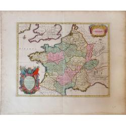
Praefectura generalis Languedociae olim Occitania.
Detailed map of Languedoc and contiguous regions. Published by Gerard and Leonard Valk.
Date: Amsterdam, 1740
Selling price: ????
Please login to see price!
Sold in 2011
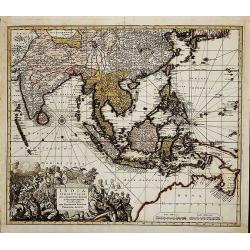
India Orientalis
First state (before the privilege, which was granted not before 1740). Map of South-East Asia showing the area between India in the West and Japan and Australia in the Ea...
Date: Augsburg, c. 1730-1740
Selling price: ????
Please login to see price!
Sold in 2014
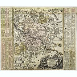
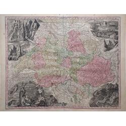
Accuratissima delineatio Geographica Dioecesis Ac Prefecture Dresdensis. . .
Detailed map centered of Dresden. Legend in the left and the right of the map. Beautiful title cartouche in the lower right corner.This edition by Seutter, another, later...
Date: Augsburg, c. 1740
Selling price: ????
Please login to see price!
Sold in 2015
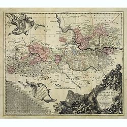
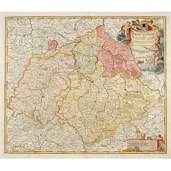
Anhaltinus Principatus Stirpis Ascaniensis felicitate hodiè florens geographi. . .
Map of Anhalt in eastern Germany, reaching from Magdeburg to Wittenberg, Halle/Saale and Quedlinburg. Large and very decorative pictorial cartouche, two further baroque c...
Date: Augsburg, 1740
Selling price: ????
Please login to see price!
Sold in 2012
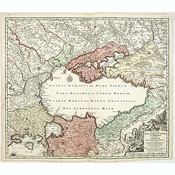
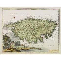
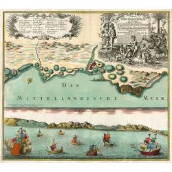
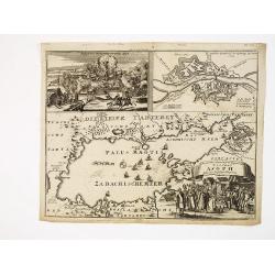
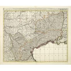
Nova et accurata Tartariae Europae seu Minoris et in specie Crimeae. . .
Rare map of the Black Sea area, showing Southern Russia, including the Ukraine, Cossack Regions and the Southern part of Muscovy, parts of Lithuania, and Poland In lower ...
Date: Augsburg, 1740
Selling price: ????
Please login to see price!
Sold in 2011
Imperii Persici in omnes suas Provincias . . . Exacte Divisi Nova Tabula Geographica. . .
Showing the eastern part of Turkey and Cyprus, Palestine, Persian Gulf, including Gulf of Oman, Caspian Sea, Iran and the north-west territories of India.Embellished with...
Date: Nurenberg, 1740
Selling price: ????
Please login to see price!
Sold in 2014
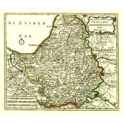
Ducatus Geldria Te Trachia Arnhemiensis Sive Velavia.
Detailed map covering Amersfoort, Elburg, Zwolle, Deventer, Zutphen, Doesburgh, Wageningen, etc.
Date: Amsterdam, 1740
Selling price: ????
Please login to see price!
Sold in 2022
Circulus Saxoniae Superioris ..
Detailed and decorative map centered Leipzig and including Dresden, Meissen, Erfurth, etc. With fine title cartouche with Hercules, putti and a fanciful view of Leipzig.
Date: Nuremberg, 1740
Selling price: ????
Please login to see price!
Sold in 2020
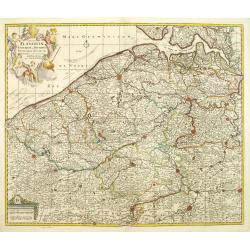
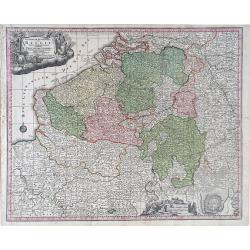
Comitatus Flandriae universe in ditiones. . .
Detailed map of Flandriae. Showing the cities of Lens, Lille, Bethune, Brugge, Gent. Beautiful title cartouche surrounded by 5 cherubs.
Date: Amsterdam, 1740
Selling price: ????
Please login to see price!
Sold in 2011
![[Portrait] Johannes Baptista Homann . . .](/uploads/cache/31237-250x250.jpg)
[Portrait] Johannes Baptista Homann . . .
Stunning full portrait of the Imperial Geographer of the Holy Roman Empire, Johann Baptist Homann (1664-1724) who was born in the Bavarian town of Kammlach. Educated at a...
Date: Nuremberg, c.1740
Selling price: ????
Please login to see price!
Sold in 2020
Isoletta Desima abittata Dagli Olandesi nel Giappone..
Bird's-eye view of Deshima copied from a manuscript by Voogt, who was second-in-command on Deshima in 1713. The island is viewed from the landside, depicting the developm...
Date: Venice, 1740
Selling price: ????
Please login to see price!
Sold in 2020
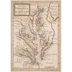
A new map of Virginia and Maryland.
Detailed folding map of the Chesapeake Bay region, showing towns, rivers, inlets, shoals, Islands, and other details. Predates the resolution of the Dispute between the P...
Date: London 1741
Selling price: ????
Please login to see price!
Sold
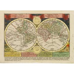
Globus Terrestris ex probatissimis recentiorum?.
Attractive copper engraved map of the world. Charming double hemisphere map surrounded by engravings of the heavens and natural phenomena such as waterspouts, a rainbow, ...
Date: Leipzig, 1741
Selling price: ????
Please login to see price!
Sold
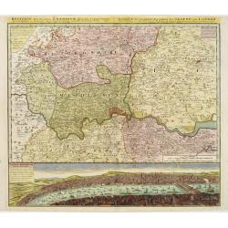
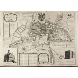
Regionis, quae est circa Londinum ..
Detailed map of greater area of London. At bottom an panoramic view (116x569mm). A most decorative item.
Date: Nuremberg 1741
Selling price: ????
Please login to see price!
Sold
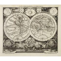
Tab. I. Geographia et Astronomia.
Small and very decorative double hemisphere map with California depicted as an Island.Australia includes the western and northern coasts and the discoveries of Van Diemen...
Date: Leipzig 1741
Selling price: ????
Please login to see price!
Sold
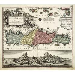
Insula Creta nunc Candia. . .
One of the most spectacular maps of Crete, divided into its four territories, and the islands to its north. The lower part is filled with a bird's-eye view of the city of...
Date: Augsburg, 1741
Selling price: ????
Please login to see price!
Sold in 2011
Novus Orbis potius Altera Continens Sive Atlantis Insula . . .
This is a very unusual map of the Americas, noted in the cartouche to illustrate the mythical island of Atlantis. The Great Lakes are shown but are still very misshapen a...
Date: Paris, 1741
Selling price: ????
Please login to see price!
Sold in 2011
Gronlandia antiqua secundum utramque partem Orientalem & Occidentalem . . .
A rare map of Greenland showing the southern part of Greenland, Davis Strait, and part of Baffin Island, including Cape Dyer. Decorative elements include ships and Inuits...
Date: Copenhagen, Johan Cristoph Groth, 1741
Selling price: ????
Please login to see price!
Sold in 2014
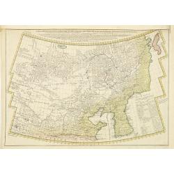
A General Map of Eastern and Western Tatary, commonly call'd Tartray, drawn from the Particular Maps of the Jesuit Missionaries. . .
Important map covering the region from the Gobi Desert to the coast, and including Korea. Including the Great Wall. The Korean peninsula is a bit distorted, and covered w...
Date: London, T.Gardner, 1738-1741
Selling price: ????
Please login to see price!
Sold in 2010
A New and Accurate Plan of the Ancient Borough of Bury Saint Edmunds in the Country of Suffolk By Alexander Downing. 1740
Important and very rare plan of Bury St. Edmunds by A. DowningA large and detailed copper engraved plan of Bury St. Edmunds, Suffolk, drawn and published by Alexander Dow...
Date: London, 1741
Selling price: ????
Please login to see price!
Sold in 2010
Gallia vetus ex C.Iulii Caesaris Comentariis Descripta.
Sanson map of France republished by the Covens and Mortier firm, with fine color. Depicts France described by Julius Caesar marking the locations of tribes and ancient to...
Date: Amsterdam, 1741
Selling price: ????
Please login to see price!
Sold in 2010
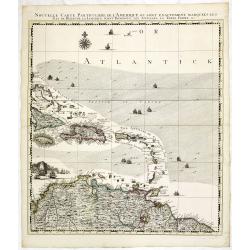
Nouvelle Carte Particuliere de l\'Amerique ou sont Exactement Marquees les Iles de Bermude, la Iamaique, Saint Domingue, les Antilles la Terre Ferme. . .
The lower right maps, with its own border title, of the four sheet Dutch edition of Popple's monumental map of North America.It covers the region from Bermuda through the...
Date: Amsterdam, 1741
Selling price: ????
Please login to see price!
Sold in 2013

Platea ac Templum D: D: Joannis et Pauli et proxime magnum Sodalitium D. . .
Very fine etching with engraving by Michele Giovanni Marieschi (1696-1743), from the book "Magnificentiores selectioresque urbis Venetiarum prospectus".Michele ...
Date: Venice, 1741
Selling price: ????
Please login to see price!
Sold in 2014
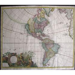
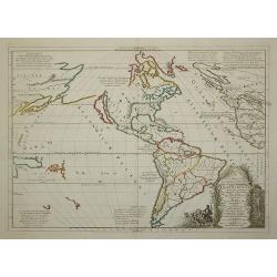
America Aurea Pars Altera Mundi.
Extremely rare and gorgeous map of America, seldom offered on an auction. California is taken from the second Sanson map published by the Valk family, with rugged coastli...
Date: Amsterdam, 1741
Selling price: ????
Please login to see price!
Sold in 2014
Die Europaeische oder kleine Tartarey, nebst den angraentzenden Laendern. . ..
Showing the Black Sea region. Uncommon map from the "Atlas Selectus" by the German cartographer Johann Georg Schreiber (1676-1750). Schreiber followed in the fo...
Date: Leipzig, 1741
Selling price: ????
Please login to see price!
Sold in 2015
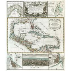
![[Gulf of Mexico showing entire Texas coast, and extending east to Florida]](/uploads/cache/37159-250x250.jpg)
[Gulf of Mexico showing entire Texas coast, and extending east to Florida]
Untitled sheets from Ottens’ important 6-sheet wall map: "Grand Théâtre de la Guerre en Amérique suivant les plus nouvelles observations des Espagnols, Anglois,...
Date: Amsterdam, 1741
Selling price: ????
Please login to see price!
Sold in 2016
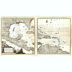
Nouvelle Carte Particuliere de l'Amerique ou sont Exactement Marquees les Iles de Bermude, la Iamaique, Saint Domingue, les Antilles la Terre Ferme. . .
The two lower maps, with their own border title, of the four-sheet Dutch edition of Popple's monumental map of North America.It covers the region from Bermuda through the...
Date: Amsterdam, 1741
Selling price: ????
Please login to see price!
Sold
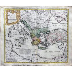
Imperii Turcici Europaei Terra in primis Graeciae.
A fine, large map delineating the Eastern Mediterranean with the possession of the Turkish empire. Homann Heirs (of Johann Baptist and Johann Christof) published differen...
Date: Nurnberg, 1741
Selling price: ????
Please login to see price!
Sold in 2018
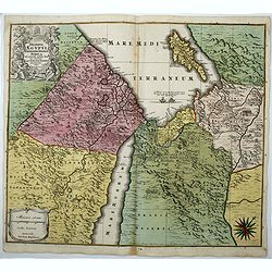
Deserta Aegypti Thebaidis, Arabiae, Syriae etc.
An attractive map of Egypt, northern Arabia, the Holy Land, Syria and Cyprus. From Seutter's "Atlas Novus". Map shows many physical features, biblical scenes, s...
Date: Augsburg, 1741
Selling price: ????
Please login to see price!
Sold in 2017