Browse Listings
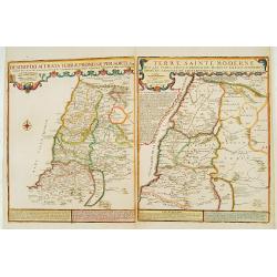
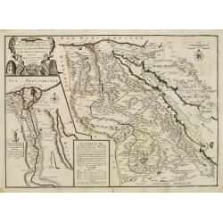
Descriptio Acurata Terrae Promissae.. Terre Sainte Moderne.
To the left a very attractive map of Palestine on both sides of the Jordan, after Philippe de La Rue. To the right hand side a map of Terre Sainte Moderne , under Turkish...
Date: Paris 1720
Selling price: ????
Please login to see price!
Sold
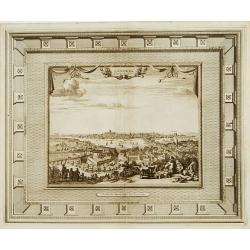
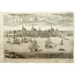
Londres capitale de l'Angleterre.
Fine and uncommon panoramic view of London. The view is printed within a large, elaborately engraved mock-frame border, which was prepared with a blank centre so that the...
Date: Leiden 1720
Selling price: ????
Please login to see price!
Sold
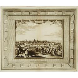
La ville de Dantzic dans la Prusse Royale.
Fine and uncommon panoramic view of Dantzig. The view is printed within a large, elaborately engraved mock-frame border, which was prepared with a blank center so that th...
Date: Leiden, 1720
Selling price: ????
Please login to see price!
Sold
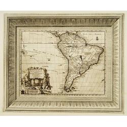
L'Amérique Méridionale..
Fine and uncommon map of south America. Very decorative title cartouche on the lower left corner. The map is printed within a large, elaborately engraved mock-frame borde...
Date: Leiden 1720
Selling price: ????
Please login to see price!
Sold
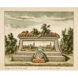
Vue de la Ville de Delft.
A very fine and decorative view of the city of Delft. Includes a title in Dutch and French underneath.
Date: Amsterdam c.1720
Selling price: ????
Please login to see price!
Sold in 2019
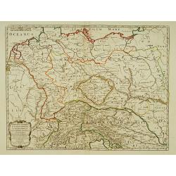
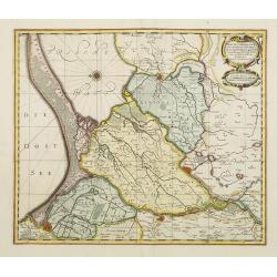
Germania Antiqua in IV. Magnos populos, in minores populos, et in minimos, distincta..
A fine map of ancient Germany, Poland and the Netherlands.Nicolas Sanson was to bring about the rise of French cartography, although the fierce competition of the Dutch w...
Date: Paris 1720
Selling price: ????
Please login to see price!
Sold in 2022
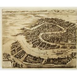
Celeberrima Urbs Venetiae. (Venice)
Precise, beautiful bird's-eye view of Venice and neighboring islands (Murano, Burano, Torcello and Mazorbo), clearly depicting the city's architectural landmark. The surr...
Date: Amsterdam 1720
Selling price: ????
Please login to see price!
Sold
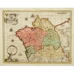
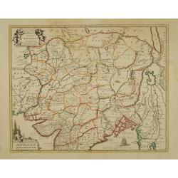
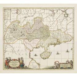
Gallaecia Regnum.
Fine map of part of Spain.
Date: Amsterdam, 1720
Selling price: ????
Please login to see price!
Sold
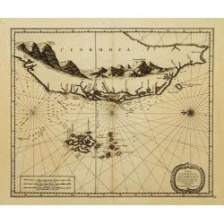
l'Isle de Formosa..
A decorative map of the west coast of Taiwan and the Pescadores Islands (Penghu), showing little detail of the Taiwanese inland, apart from the immense mountain range. Fo...
Date: Leiden 1720
Selling price: ????
Please login to see price!
Sold
![Nova Helvetiae tabula geographica [Sheet 1 of 4]](/uploads/cache/17583-250x250.jpg)
Nova Helvetiae tabula geographica [Sheet 1 of 4]
Johann Jakob Scheuchzer (August 2, 1672 ? June 23, 1733) was a Swiss scholar born at Zürich. In 1712 he published, a map of Switzerland in four sheets (scale 1/290,000),...
Date: Amsterdam 1720
Selling price: ????
Please login to see price!
Sold
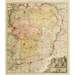
Brabantiae Ducatus
On the lower right a cartouche embellished with figures, trees, birds, fruits and the heraldic arms of Brabant, held by a female figure. At bottom a dedication to Herman ...
Date: Amsterdam 1720
Selling price: ????
Please login to see price!
Sold
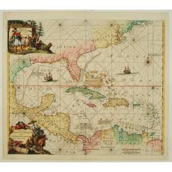
Indiarum Occidentalium Tractus Littoralis cum Insulis..
One of the most splendidly engraved Dutch charts of the Caribbean with two decorative cartouches, one of which illustrates Native American cannibals preparing a meal. Inc...
Date: Amsterdam 1720
Selling price: ????
Please login to see price!
Sold
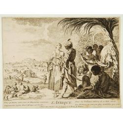
L'Afrique.
Print depicting natives from Africa with lions and elephants.
Date: Paris, 1690-1720
Selling price: ????
Please login to see price!
Sold
Russia Alba, sive Moscovia, regio valde extensa, divisaque in regni..
European Russia, including Ukraine.
Date: Amsterdam 1720
Selling price: ????
Please login to see price!
Sold
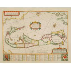
Mappa Aestivarum Insularum, alias Barmudas..
The map is the rare re-issue of the Blaeu's copperplate of 1630. The map includes the arms of Bermuda and England, and lists proprietors of the various tribes into which ...
Date: Amsterdam 1720
Selling price: ????
Please login to see price!
Sold
Magni Mogolis Imperium de novo correctum et Divisum..
A rare issue of this attractive map of northern India and Central Asia. The map was originally published by F.de Wit. P.Mortier acquired de Wit's stock of copperplates in...
Date: Amsterdam 1720
Selling price: ????
Please login to see price!
Sold
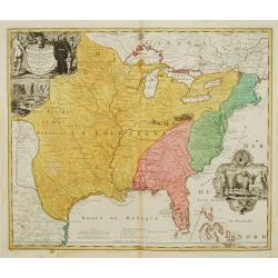
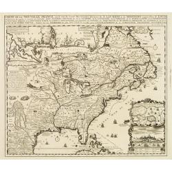
Amplissimae Regionis Mississipi,.. Provinciae Ludovicianae.
Attractive map of present-day U.S. from Nouveau Mexico to the Atlantic, centring on the French province of Louisiana, with the English colonies and Spanish Florida indica...
Date: Nuremberg 1720
Selling price: ????
Please login to see price!
Sold
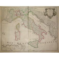
L´Italie...
Title: L´Italie. Dressée sur les Observations de Mrs. de l´Academie Royale des Sciences sur celles du R.P. Riccioli de la Compagnie de Jesus et autres Astronomes du pa...
Date: France, c. 1720
Selling price: ????
Please login to see price!
Sold in 2018
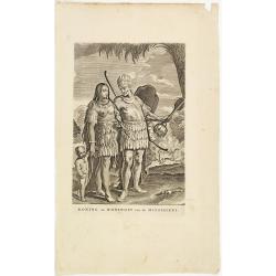
Koning en Koningin van de Mississippi.
An Indian couple of the Mississippi area. From a book satirizing the disastrous Mississippi scheme (1718-1720) of the French Compagnie d'Occident and the speculation of i...
Date: Amsterdam, 1720
Selling price: ????
Please login to see price!
Sold in 2013
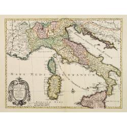
Italia Antiqua cum insulis Sicilia Sardinia..
Fine map of ancient Italy, including Sardinia and Corsica.A Amsterdam issue of the map by Nicolas Sanson.
Date: Amsterdam 1720
Selling price: ????
Please login to see price!
Sold
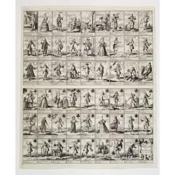
Pasquins windkaart op de windnegotie van 't Iaar 1720
Pasquin's wind card on the wind trade of the year 1720. Set of 52 illustrated playing-cards with human figures and a little explanation under each one. Interesting is the...
Date: Amsterdam 1720
Selling price: ????
Please login to see price!
Sold
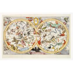
Hemel globe. Coeli enarrant Gloriam del.
Charming double hemisphere celestial map on a polar projection. The map depicts the ecliptic pole to ecliptic, joined through winter solstice.It is based on the Hondius m...
Date: Amsterdam 1720
Selling price: ????
Please login to see price!
Sold
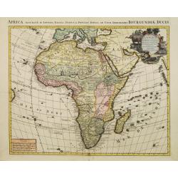
L'Afrique dressée sur les observations de M. de l'academie Royale des Sciences..
Very fine engraved map of Africa with a very decorative title cartouche. Giving good detail along the coast.An version printed in Amsterdam after De L'Isle.
Date: Amsterdam 1720
Selling price: ????
Please login to see price!
Sold
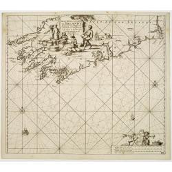
Nieuwe pascaert, vande suyt syde van Yrlandt..
Showing the south coast of Ireland.Latitude scale, compass rose and system of rhumb lines, soundings, anchorage's, etc. In lower right corner with added number 20.
Date: Amsterdam 1720
Selling price: ????
Please login to see price!
Sold
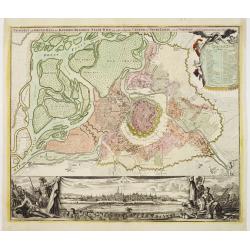
Prospect und Grund-riss.. stadt Wien.
The upper part shows Vienna with adjoining regions. The bottom part shows a prospect of the town.
Date: Nuremberg 1720
Selling price: ????
Please login to see price!
Sold
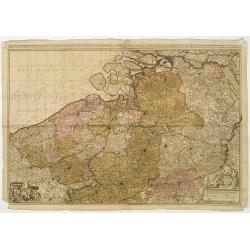
Het groot en by naar geduurige schouwburg van den Europeeschen Oorlogh behelsende Brabant, Vlanderen, Henegouwe, Namur en Luyck, etc. te Amsterdam by P.Schenk.
Rare and interesting map of Brabant, and present-day Belgium. The wall map consists of two pages, pasted together and in top a separate printed slip with its title Het gr...
Date: Amsterdam 1720
Selling price: ????
Please login to see price!
Sold
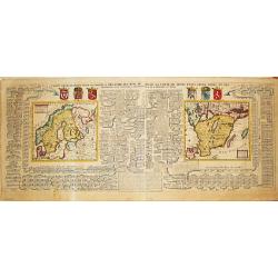
Carte Genealogique pour conduire a l' histore des Rois du Nord, la Carte de leurs etats, leurs Armes &tc. / nouvelle cart du Royaume de Suede. / Carte du Royaume de Gothie.
Henri Abraham Chatelain was a Amsterdam-based geographer and publisher. His main product is the 'Atlas Historique et Méthodique', in seven volumes, published between 171...
Date: Amsterdam, 1710-1720
Selling price: ????
Please login to see price!
Sold
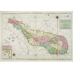
Carte particuliere de L'Isle Dauphine ou Madagascar..
An impressive large sheet of the island of Madagascar. Numerous place names, soundings and sand banks are shown round the island and the regions are defined in original ...
Date: Amsterdam 1720
Selling price: ????
Please login to see price!
Sold in 2012
Habillemens d'Hommes & Femmes de diverses provinces de la Chine avec.....la Pont volant de la Provence de Xensi.
Henri Abraham Chatelain was a Amsterdam-based geographer and publisher. His main product is the 'Atlas Historique et Méthodique', in seven volumes, published between 171...
Date: Amsterdam, c. 1720
Selling price: ????
Please login to see price!
Sold
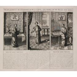
Habillement de l'Empereur de la Chine & des Dames de son Palais
Henri Abraham Chatelain was a Amsterdam-based geographer and publisher. His main product is the 'Atlas Historique et Méthodique', in seven volumes, published between 171...
Date: Amsterdam, c. 1720
Selling price: ????
Please login to see price!
Sold
Inspruck Ville d'Allemagne Capitale du Comte de Tyrol.
A very RARE panoramic view of the city of Innsbruck.The plate is numbered in red pencil in upper right corner.Engraved by Pierre Aveline (Paris, c.1656 - 23 May 1722). He...
Date: Paris, 1690-1720
Selling price: ????
Please login to see price!
Sold in 2016
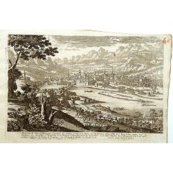
Ansicht von Sidney von der Südseite, und der Mündung des Parramatta Flusses
General view of Sydney, shown from the Parranatta River estuary.
Date: 1720
Selling price: ????
Please login to see price!
Sold
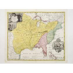
Amplissimae Regionis Mississipi,.. Provinciae Ludovicianae..
Attractive map of present-day U.S. from Nouveau Mexico to the Atlantic, centering on the French province of Louisiana, with the English colonies and Spanish Florida indic...
Date: Nuremberg 1720
Selling price: ????
Please login to see price!
Sold
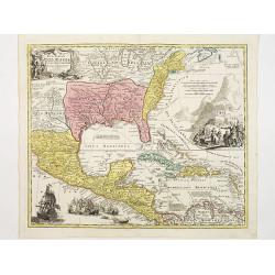
Regni Mexicani seu Novae Hispaniae, Floridae, Novae ..
The map shows the eastern sea board of America, the West Indies and the various estates and countries that border the Gulf of Mexico, with decorative -uncolored- cartouch...
Date: Nuremberg 1720
Selling price: ????
Please login to see price!
Sold
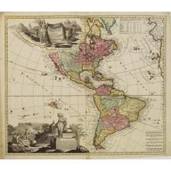
Totius Americae Septentrionalis et Meridionalis..
Richly ornamented map of North and South America. Title cartouche bottom left is copied from De Fer's map of 1699 and cartouche containing text (top left) is based on De ...
Date: Nuremberg 1720
Selling price: ????
Please login to see price!
Sold
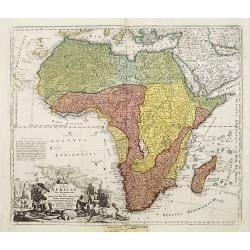
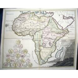
Totius Africae nova repraesentatio..
Richly ornamented map of Africa and the Arabia Peninsula. With an extraordinary delineation of the Nile which is based partly on Ptolemy (rising in two large lakes, Zaire...
Date: Nuremberg 1720
Selling price: ????
Please login to see price!
Sold
Insulae Iavae Borneo Sumatrae..
No text on verso. A finely engraved map in the classic Dutch baroque style of Java and parts of Bali, Sumatra, and Borneo.
Date: Amsterdam 1720
Selling price: ????
Please login to see price!
Sold
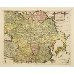
Magnae Tartariae Magni Mogolis Imperii Japoniae et Chinae
The map stretches from the Caspian Sea in the West to Formosa and Japan in the East. Korea rightly correctly depicted as a peninsula.With decorative title cartouche held ...
Date: London 1720
Selling price: ????
Please login to see price!
Sold
Le Gouvernement de Normandie...
Very detailed map of Normandy. In the south the river Loire, and in utmost left part of Jersey.
Date: Amsterdam, ca. 1720
Selling price: ????
Please login to see price!
Sold
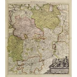
Brabantiae Ducatus.
On the lower right a cartouche embellished with figures, trees, birds, fruits and the heraldic arms of Brabant, held by a female figure. At bottom a dedication to Herman ...
Date: Amsterdam, 1720
Selling price: ????
Please login to see price!
Sold in 2011
-250x250.jpg)
Vue et description de la Ville de Meaco Capitale du Japon.
Top part of the print shows a panoramic view of Meaco (Kyoto) at that time the capital of Japan, with a coach and horses in the foreground. Other parts show among other t...
Date: Amsterdam, 1720
Selling price: ????
Please login to see price!
Sold in 2014
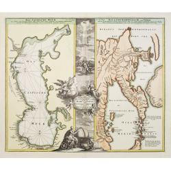
Geographica..Mare Caspium altera Kamtzadaliam..
Two maps on one sheet. On the right a fascinating and confused picture of Hokkaido, the Kuriles and Kamchatka, based on reports of recent Russian expeditions sent by Pete...
Date: Nuremberg 1720
Selling price: ????
Please login to see price!
Sold
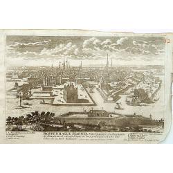
Koppenhage Hafnia Ville capitale du Royaume de Danemark.
A very RARE panoramic view of the city of Copenhagen, with a numbered legend in both lower corner.The plate is numbered in red pencil in upper right corner.Engraved by Pi...
Date: Paris 1690-1720
Selling price: ????
Please login to see price!
Sold
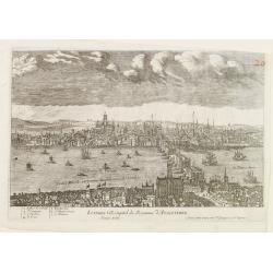
Londres Ville Capitale du Royaume d'Angleterre.
A very RARE panoramic view of the city of London, with a numbered legend in lower left corner.The plate is numbered in red pencil in upper right corner.Engraved by Jean C...
Date: Paris 1690-1720
Selling price: ????
Please login to see price!
Sold
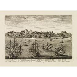
Lisbone.
A very RARE panoramic view of the city of Lisbon, including a numbered legend in both lower corners.Published by the brothers Chéreau, active in Paris at rue st.Jacques ...
Date: Paris c.1720
Selling price: ????
Please login to see price!
Sold
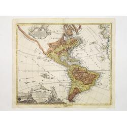
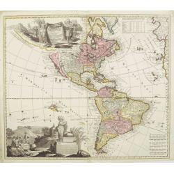
America tam Septentrionalis quam Meridionalis..
An uncommon map of the Americas with two superb pictorial (uncolored) cartouches. Engraved by A.F. Zurner and based largely on Visscher and Sanson. California is shown as...
Date: Amsterdam 1720
Selling price: ????
Please login to see price!
Sold
Carte de la Nouvelle France, ou se voit le cours des Grandes Rivieres de S. Laurens & de Mississipi..
Derived from de Fer's 1718 map, from west of the Mississippi it contains a mass of inland detail with notes and vignettes of the indigenous peoples and fauna of North Ame...
Date: Amsterdam 1720
Selling price: ????
Please login to see price!
Sold
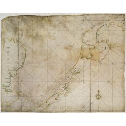
V.O.C. Chart of the Netherlands, south-eastern England and the English Channel.
V.O.C. manuscript vellum chart of the Netherlands, south-eastern England and the English Channel. Depicting the southern part of the North Sea, from the English Channel t...
Date: Amsterdam ca. 1720
Selling price: ????
Please login to see price!
Sold
De Beschryving van de Rysen Pauli..
Highly decorative map of the eastern part of the Mediterranean. At the bottom are a cartouche and four vignettes with episodes from the travels of the Apostle Paul.
Date: Amsterdam, 1720
Selling price: ????
Please login to see price!
Sold
Riga Capitale de la Province de Livonie.
A very RARE panoramic view of the city of Riga.The plate is numbered in red pencil in upper right corner.Engraved by Pierre Aveline (Paris, c.1656 - 23 May 1722). He was ...
Date: Paris 1690-1720
Selling price: ????
Please login to see price!
Sold
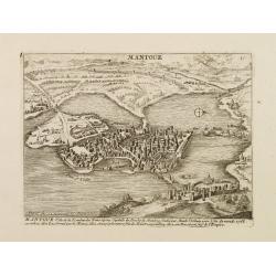
Mantoue Ville de la Lombardie Transalpine.
A very RARE panoramic view of the city of Mantua, including a numbered legend in the lower part.Published by the brothers Chéreau, active in Paris at rue st.Jacques au G...
Date: Paris, c.1720
Selling price: ????
Please login to see price!
Sold in 2010
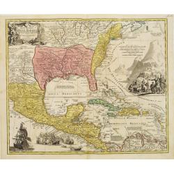
Regni Mexicani seu Novae Hispaniae, Floridae, Novae ..
The map shows the eastern sea board of America, the West Indies and the various estates and countries that border the Gulf of Mexico, with decorative -uncolored- cartouch...
Date: Nuremberg 1720
Selling price: ????
Please login to see price!
Sold
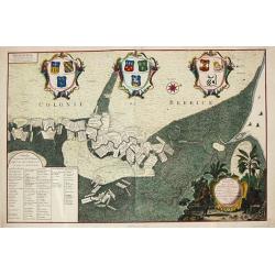
Platte Grond van Rio de Berbice.
Jan Daniel Knapp?s large-scale map of the Dutch plantations along the river Berbice in present day Guyana. The map shows the division of property and plantations and the ...
Date: Amsterdam, 1720
Selling price: ????
Please login to see price!
Sold
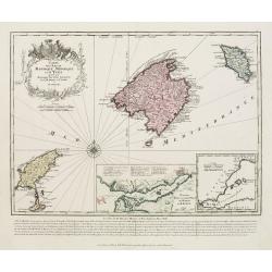
Carte des isles de Maiorque Minorque et d'Yvice..
Map of the Balearic Islands of Mallorca, Menorca and Ibiza with large cartouche and inset plan of the harbour of Mahon and a small overall map of the western Mediterranea...
Date: Augsburg 1720
Selling price: ????
Please login to see price!
Sold
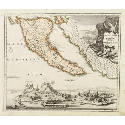
Corcyrae insulae, vulgo Corfv planities unacum parte Greciae ..
Corfu with part of the coastline of Greece, large battle-scene title vignette upper right, and panoramic view of Corfu harbour and fortress across the lower portion of th...
Date: Nuremberg 1720
Selling price: ????
Please login to see price!
Sold
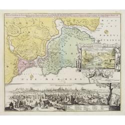
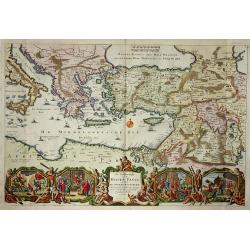
Accurate Vorstellung der Orientalisch Kayserlichen Haupt- und Residenz-Stadt Constantinopel samt ihrer Gegend und zweven berühmten Meer-Engen Bosphoro Thracio und Hellsponto.
Fine and sought-after plan of Istanbul. The allegorical title cartouche is clearly inspired by the oriental world using symbols like the half-moon and the oil lamp. Wisdo...
Date: Nuremberg 1720
Selling price: ????
Please login to see price!
Sold
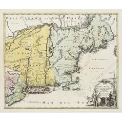
Nova Anglia Septentrionali Americae implantata ..
German interest in North America was high during the first half of the eighteenth century when Johan Baptiste Homann was the leading German cartographer. During this peri...
Date: Nuremberg 1720
Selling price: ????
Please login to see price!
Sold
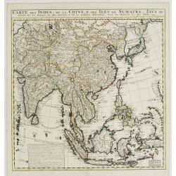
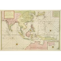
Carte des Indes, de la Chine & des Isles de Sumatra, Java &c..
This fine and quite detailed general map extends from northern Japan to Timor and from India to New Guinea.Here, the Terre de Yeco in northern Japan is still joined to th...
Date: Amsterdam 1720
Selling price: ????
Please login to see price!
Sold
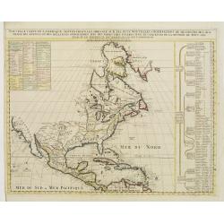
Nouvelle Carte de l' Amerique Septentrionale Dressee sur les plus Nouvelles Observations de Messieurs de l' Academie..
Great map of North America with well developed cartography in the Great Lakes and Mississippi River.It includes all of Central America and the West Indies. The English se...
Date: Amsterdam 1720
Selling price: ????
Please login to see price!
Sold
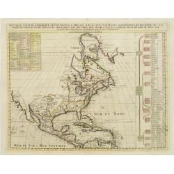
Nouvelle Carte de l' Amerique Septentrionale Dressee sur les plus Nouvelles Observations de Messieurs de l' Academie..
Great map of North America with well developed cartography in the Great Lakes and Mississippi River.It includes all of Central America and the West Indies. The English se...
Date: Amsterdam 1720
Selling price: ????
Please login to see price!
Sold
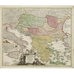
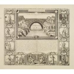
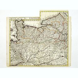
Fluviorum in Europa principis Danubii cum Adiacentibus..
Map showing the course of the river Danube from Ingolstadt to the Black Sea and the adjacent countries with Italy and Greece.In an inset the course of the river Danube fr...
Date: Nuremberg 1720
Selling price: ????
Please login to see price!
Sold
Africa Vetus.
Map of ancient Africa, with the geographical features known to the ancients and decorated with a vignetter and 23 Roman coins & medallions. A interesting and highly d...
Date: Nuremberg, 1720
Selling price: ????
Please login to see price!
Sold
Nouvelle Carte de Pologne.
Henri Abraham Chatelain was a Amsterdam-based geographer and publisher. His main product is the 'Atlas Historique et Méthodique', in seven volumes, published between 171...
Date: Amsterdam, c.1720
Selling price: ????
Please login to see price!
Sold
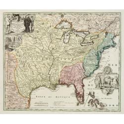
Amplissimae Regionis Mississipi,.. Provinciae Ludovicianae..
Attractive map of present-day U.S. from Nouveau Mexico to the Atlantic, centering on the French province of Louisiana, with the English colonies and Spanish Florida indic...
Date: Nuremberg 1720
Selling price: ????
Please login to see price!
Sold

Accurate Vorstellung der Orientalisch Kayserlichen Haupt- und Residenz-Stadt Constantinopel samt ihrer Gegend und zweven berühmten Meer-Engen Bosphoro Thracio und Hellesponto..
A lovely and well engraved plan of Istanbul. A large inset features a bird's-eye view of the Bosphorus with several ships in the foreground framed with an allegorical car...
Date: Nuremberg 1720
Selling price: ????
Please login to see price!
Sold
Carte des costes de l'Asie sur l'Ocean..
Pristine nautical chart with an inset of southern coast of southern Australia and Tasmania in the wake of Tasman and other 17th century Dutch explorations of these region...
Date: Amsterdam 1720
Selling price: ????
Please login to see price!
Sold
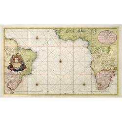
Nieuwe Wassende graadige Pas-kaart van de kust van Guinea en Brasilia..
Engraved by I.van Anse. A very representative example of a Dutch chart of the Atlantic.The chart shows the western coast of Africa but the information provided in the map...
Date: Amsterdam c.1720
Selling price: ????
Please login to see price!
Sold
Tractuum Borussiae, circa Gedanum et Elbingam..
A decorative map including Gdansk, Elblag and Malbork.
Date: Amsterdam, 1720
Selling price: ????
Please login to see price!
Sold
Le Cours Du Nil, Suivant Les Auteurs Modernes et les dernieres Relations.
Two maps on one sheet: a general depiction of the Nile Valley and Egypt, and a smaller map focusing on the delta region with detail of ancient civilization.
Date: Paris, 1720
Selling price: ????
Please login to see price!
Sold
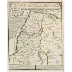
Terre Sainte Moderne que les Turcs..
Rare map of the Promised Land by De Fer after Phil de la Rue.Presents some explicatory text at the bottom and under the title cartouche.
Date: Paris, 1720
Selling price: ????
Please login to see price!
Sold
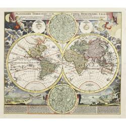
Planiglobii Terrestris Cum Utroq Hemisphaerio.
This is one of the most decorative eighteenth century world maps, surrounded by vivid engravings of natural phenomena such as waterspouts, a rainbow, earthquakes, and a v...
Date: Nuremberg, ca. 1720
Selling price: ????
Please login to see price!
Sold

Title page: Atlas Historique..
Very decorative title page. Engraved by B.Picart. Showing representations of the four continents, extensive shipping in background scene and in top Mercury.
Date: Amsterdam, 1720
Selling price: ????
Please login to see price!
Sold
Iunnan, Queicheu, Quangsi, et Quantung..
A beautifully engraved map of Southern China covering Hainan and the Pearl River Delta with Macao and the islands around present-day Hong Kong.
Date: Amsterdam, 1720
Selling price: ????
Please login to see price!
Sold
America tam Septentrionalis quam Meridionalis..
An uncommon map of the Americas with two superb pictorial (uncolored) cartouches. Engraved by A.F. Zürner and based largely on Visscher and Sanson. California is shown a...
Date: Amsterdam, 1720
Selling price: ????
Please login to see price!
Sold in 2020
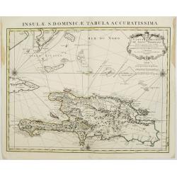
Carte de l'Isle de Saint Domingue Dressée en 1722 pour l'usa
Map of the island Hispaniola, now Haiti and the Dominican Republic. Embellished with a charming title cartouche and two compass roses. Shows the south easternmost part of...
Date: Amsterdam, 1720
Selling price: ????
Please login to see price!
Sold in 2008
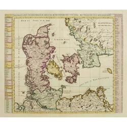
Nouvelle Carte Geographique du Royaume de Dannemarck avec une table des villes les plus remarquables.
Map of Denmark with a key table to the towns on both sides.Zacharie Chatelain (d.1723) was the father of Henri Abraham (1684-1743) and Zacharie Junior (1690-1754).They wo...
Date: Amsterdam, ca. 1720
Selling price: ????
Please login to see price!
Sold
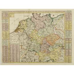
Nouvelle Carte de l'Alemagne avec des tables des branches de la noblesse..
Map of Germany including parts of the neighboring countries with a key table to the towns on both sides.Zacharie Chatelain (d.1723) was the father of Henri Abraham (1684-...
Date: Amsterdam, ca. 1720
Selling price: ????
Please login to see price!
Sold
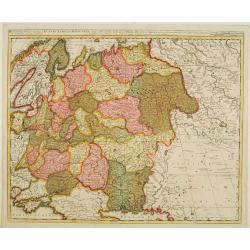
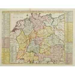
Nouvelle Carte des Cercles de l'Empire, avec des tables des divers souverains..
Map of Germany including parts of the neighboring countries with a key table to the towns on both sides.Zacharie Chatelain (d.1723) was the father of Henri Abraham (1684-...
Date: Amsterdam, ca. 1720
Selling price: ????
Please login to see price!
Sold
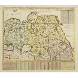
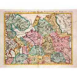
Nouvelle Carte de Moscovie où sont representés les differents etats de sa Maiesté Czarienne..
Map of Russia Tartary and part of China with key tables to the towns. Depicting the different states belonging to the Czar in Asia and Europe, showing the path of one of ...
Date: Amsterdam, ca. 1720
Selling price: ????
Please login to see price!
Sold
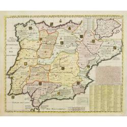
Carte Historique et Geographique des Royaumes d'Espagne et de Portugal..
Historical and geographical map of the kingdoms of Spain and Portugal divided according to their kingdoms and provinces. Including indexes, notes and an inset map of the ...
Date: Amsterdam, ca. 1720
Selling price: ????
Please login to see price!
Sold