Browse Listings
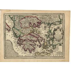
La Grece..
Nice small map of Greece, with decorative cartouches.
Date: Paris, 1719
Selling price: ????
Please login to see price!
Sold
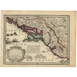
Les Isles et coste de la Dalmatie.
Nice small map of the Balkan coast.
Date: Paris, 1719
Selling price: ????
Please login to see price!
Sold
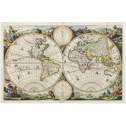
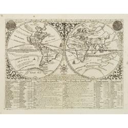
Werelt Caert.
Beautiful double hemisphere from a Dutch Bible. Surrounded by allegorical representations of the continents, based on Visscher.California is an island with a flat norther...
Date: Amsterdam 1719
Selling price: ????
Please login to see price!
Sold
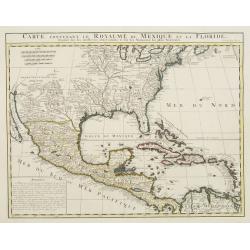
Carte contenant le Royaume du Mexique et la Floride.
ñ This is a derivative of Delisle's landmark map of the southern part of North America. The detailed map shows many English settlements along the East Coast and carefull...
Date: Amsterdam, 1719
Selling price: ????
Please login to see price!
Sold
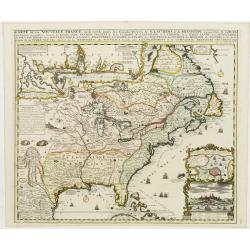
Carte de la Nouvelle France, ou se voi le cours..
Derived from de Fer's 1718 map, from west of the Mississippi it contains a mass of inland detail with notes and vignettes of the indigenous peoples and fauna of North Ame...
Date: Amsterdam 1719
Selling price: ????
Please login to see price!
Sold
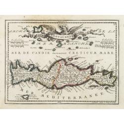
Isle et Royaume de Candie.
Uncommon small map of Crete displaying precise engraving and a flourishing, banner-style cartouche.From Le Nouveau et Curieux Atlas Geographique et Historique.. by Jacque...
Date: Paris, 1719
Selling price: ????
Please login to see price!
Sold in 2012
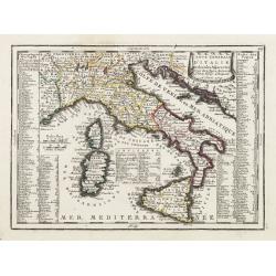
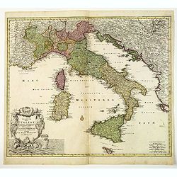
Carte Generale D'Italie Et des Isles Adjacentes..
Decorative map of Italy displaying at both sides a list containing the names of the popes. In the Tyrrhenian Sea instead, a table presents a list of the Antipopes.From Le...
Date: Paris, 1719
Selling price: ????
Please login to see price!
Sold in 2022
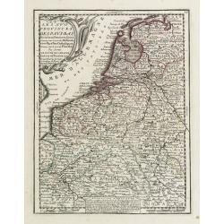
Les XVII Provinces Des Pays Bas..
Decorative map of the Low Countries, extending southwards as far as the North-East of France.From Le Nouveau et Curieux Atlas Geographique et Historique.. by Jacques Chiq...
Date: Paris 1719
Selling price: ????
Please login to see price!
Sold
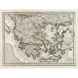
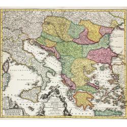
La Grece ou Partie Meridionale de la Turquie d'Europe..
Decorative map of Greece displaying precise engraving and a title cartouche flanked by 2 winged female figures, surmounted by a fan shaped shell.Another cartouche contain...
Date: Paris, 1719
Selling price: ????
Please login to see price!
Sold in 2022
Les Isles et Coste de la Dalmatie ou se Trouvent la Republique de Raguse..
Fine map of the Dalmatian coast with a decorative title cartouche.Presents vessels in the Adriatic Sea and some text containing information about the Republic of Ragusa, ...
Date: Paris, 1719
Selling price: ????
Please login to see price!
Sold in 2010
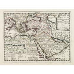
Estats de L'empire du Grand Seigneur dit Sultan et Ottomans Empereur des Turcs..
The map shows the extent of the Ottoman Empire from the Balkans to Persia, including all of Arabia and North Africa (an inset map at lower left shows the continuation of ...
Date: Paris, 1719
Selling price: ????
Please login to see price!
Sold
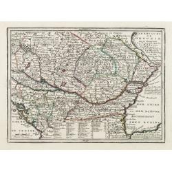
Le Royaume de Hongrie ou se trouvent La Transilvanie, La Moldavie, La Valaquie, L\'esclavonie, La Bosnie, La Servie, et la Bulgarie..
Map of Hungary including most part of southeastern Europe as far as Istanbul.It shows a text table at the bottom containing the names of Hungarian rulers.From Le Nouveau ...
Date: Paris, 1719
Selling price: ????
Please login to see price!
Sold in 2009
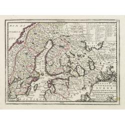
Estats de la Couronne de Suede dans la Scandinavie, ou sont Suede, Gotlande, Lapponie Suedoise, Finlande, Ingrie et Livonie. Subdivisees en leurs Provinces..
Lovely small map centered on Finland, with Sweden and much of Norway to the west, Frontieres de Moscovie to the east.Depiction of lakes, rivers and coastline reminiscent ...
Date: Paris, 1719
Selling price: ????
Please login to see price!
Sold in 2009
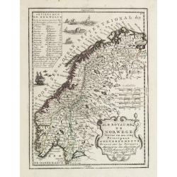
Le Royaume de Norwege Divisé en ses cinq Principaux Gouvernements..
Lovely small map of Norway, with much of Sweden to the East, vessel and sea monsters in the Norwegian Sea.It shows a text table in the upper left corner containing the na...
Date: Paris, 1719
Selling price: ????
Please login to see price!
Sold in 2017
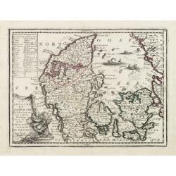
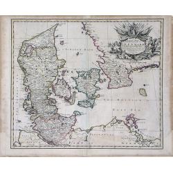
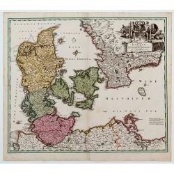
Le Royaume de Danemark Subdivisée en ses quatre Dioceses..
Lovely small map of Denmark, with decorative title cartouche.It shows a text table in the upper left corner containing the names of local rulers.From Le Nouveau et Curieu...
Date: Paris 1719
Selling price: ????
Please login to see price!
Sold
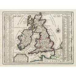
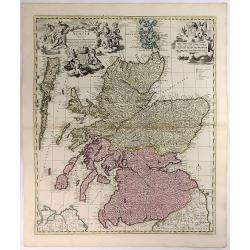
Les Royaumes D'Angleterre, D'Escosse Et D'Irlande..
Lovely small map of the British Isles with two side panels listing Scottish and English kings.From Le Nouveau et Curieux Atlas Geographique et Historique.. by Jacques Chi...
Date: Paris 1719
Selling price: ????
Please login to see price!
Sold in 2008
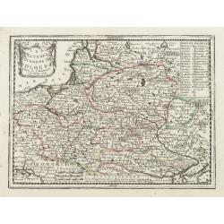
Les Estats de la Couronne de Pologne.
Lovely small map of Poland with title cartouche and a panel in the upper right corner listing local rulers.From Le Nouveau et Curieux Atlas Geographique et Historique.. b...
Date: Paris, 1719
Selling price: ????
Please login to see price!
Sold in 2008
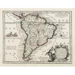
L' Amerique Meridionale qui fait l' autre Partie des Indes Occidentales, Dressée tres Exactement Suivant les Observations..
Charming small map of the South American continent with good detail. Decorated with a title cartouche with two natives in the Atlantic and a sea battle being waged in the...
Date: Paris 1719
Selling price: ????
Please login to see price!
Sold
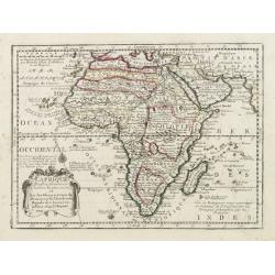
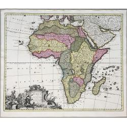
L' Afrique Dressee suivant les Auteurs les plus nouvea..
Charming map of the African continent with some interesting cartography and filled with notations.The Nile is correctly shown with its origins in Abyssinia. A large Lac d...
Date: Paris 1719
Selling price: ????
Please login to see price!
Sold
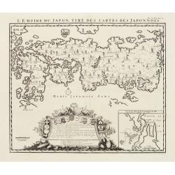
L'Empire Du Japon, Tiré Des Cartes Des Japonnois.
A good impression of this decorative map of Japan based on Reland's map of 1715, one of the earliest to use both Latin names and Japanese characters.With inset of the bay...
Date: Amsterdam 1719
Selling price: ????
Please login to see price!
Sold
Carte très curieuse de la Mer du Sud, contenant des remarque..
Based on de Fer's map of 1713. One map on 4 sheets, showing America in the middle with Europe on one side and the Pacific with Japan and China on the other. Top sheets of...
Date: Amsterdam 1719
Selling price: ????
Please login to see price!
Sold

Werelt Caert
Beautiful double hemisphere from a Dutch Bible. Surrounded by allegorical representations of the continents, based on Visscher. CALIFORNIA AS AN ISLAND with a flat northe...
Date: Dordrecht 1719
Selling price: ????
Please login to see price!
Sold
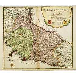
Les etats de L'eglise et de Toscane..
Rare map of Tuscany and the island of Elbe... Prepared by Nicolas de Fer.
Date: Paris, 1719
Selling price: ????
Please login to see price!
Sold
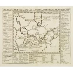
Carte particuliere du Fleuve Saint Louis..
The map covers the area of South Hudson Bay and concentrates on the great lakes. Based on the 1703 map by Lahontan.The St. Laurent is shown running into the Great Lakes f...
Date: Amsterdam, 1719
Selling price: ????
Please login to see price!
Sold
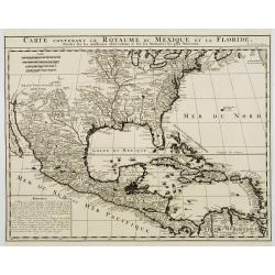
Carte contenant le Royaume du Mexique et la Floride.
This is a derivative of Delisle's landmark map of the southern part of North America.The detailed map shows many English settlements along the East Coast and carefully no...
Date: Amsterdam, 1719
Selling price: ????
Please login to see price!
Sold
Mapmonde ou Description Genrale Du Globe Terrestre.
Double hemispherical world map with descipitive text showing California as an island, tracks of several explorers around the world and Celestial images of the sun accordi...
Date: Amsterdam, 1719
Selling price: ????
Please login to see price!
Sold in 2008
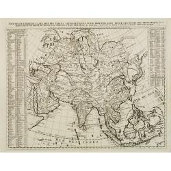
Nouvelle carte de l'Asie avec des tables..
Chatelain's map of Asia. The title is in two lines across the map. On each side border appears an index to the map's contents.From Chatelain's Atlas Historique et Méthod...
Date: Amsterdam, 1719
Selling price: ????
Please login to see price!
Sold
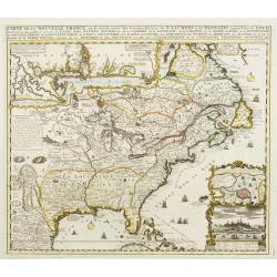
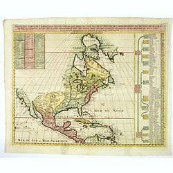
Carte de la Nouvelle France, ou se voi le cours..
Derived from de Fer\'s 1718 map, from west of the Mississippi it contains a mass of inland detail with notes and vignettes of the indigenous peoples and fauna of North Am...
Date: Amsterdam, 1719
Selling price: ????
Please login to see price!
Sold in 2009
Werelt Caert. . .
Lovely double hemisphere map from a Dutch Bible. Title inside the surrounding allegorical representations of the continents, based on Visscher. CALIFORNIA IS AN ISLAND wi...
Date: Amsterdam, 1719
Selling price: ????
Please login to see price!
Sold in 2011
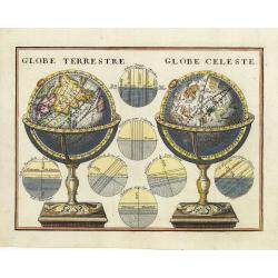
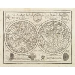
Globe Terrestre. / Globe Celeste.
A very decorative depiction of a terrestrial and celestial globe on a decorative base. The page is filled with seven diagrams.
Date: Paris, 1719
Selling price: ????
Please login to see price!
Sold in 2011
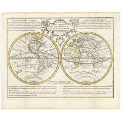
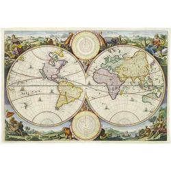
Le Globe Terrestre Representé en Deux Plans-Hemispheres..
Small double hemisphere world map featuring the Island of California and a Northwest Passage. There is little interior detail with only major nations named.Ter. de Jesso ...
Date: Paris, 1719
Selling price: ????
Please login to see price!
Sold in 2011
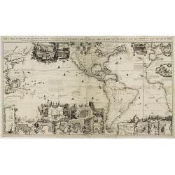
Carte Très Curieuse De La Mer Du Sud Contenant Des Remarques Nouvelles Et Tres Utiles . . .
Based on de Fer's map of 1713. One map on 4 sheets, showing America in the middle with Europe on one side and the Pacific with Japan and China on the other. Showing the v...
Date: Amsterdam, 1719
Selling price: ????
Please login to see price!
Sold in 2011
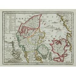
Le Royaume de Danemark Subdivisée en ses quatre Dioceses ...
Lovely small map of Denmark, with decorative title cartouche.It shows a text table in the upper left corner containing the names of local rulers.From Le Nouveau et Curieu...
Date: Paris, 1719
Selling price: ????
Please login to see price!
Sold in 2011
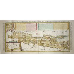
Carte de l'' Isle de Java..
This important large-scale chart of the island of Java is one of the finest 18th century maps of the island. The map is filled with details of rice fields, mountains, for...
Date: Amsterdam, 1719
Selling price: ????
Please login to see price!
Sold in 2008
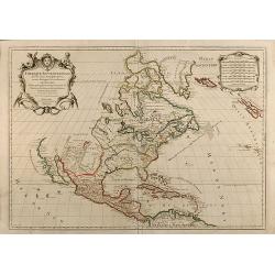
Amerique Septentrionale divisee en ses Principales Parties
Attractive map of North America. By Jaillot and Sanson. California between island and peninsula. Pacific Northwest is unexplored. Old outline color.
Date: 1719
Selling price: ????
Please login to see price!
Sold in 2010
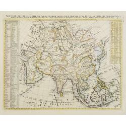
Nouvelle carte de l'Asie avec des tables..
Chatelain's map of Asia. The title is in two lines across the map. On each side border appears an index to the map's contents.From Chatelain's Atlas Historique et Méthod...
Date: Amsterdam, 1719
Selling price: ????
Please login to see price!
Sold in 2008
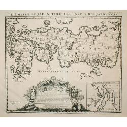
L'Empire du Japon, tire des cartes des Japonnois.
A good impression of this decorative map of Japan based on Reland's map of `1715, one of the earliest to use both Latin names and Japanese characters. With inset of the b...
Date: Amsterdam, 1719
Selling price: ????
Please login to see price!
Sold in 2009
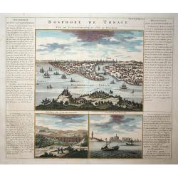
Bosphore de Thrace
This handsome folio sheet present three views of the strategically important Bosporus. At top is a large decorative bird's-eye view of Istanbul as viewed from across the ...
Date: Amsterdam, 1719
Selling price: ????
Please login to see price!
Sold in 2009
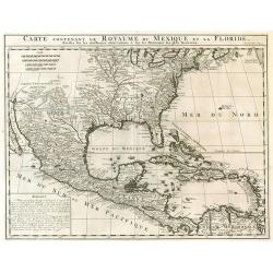
Carte contenant le royaume du Mexique et la Floride.
From Chatelains Atlas Historique. Based upon De L'Isle's landmark map of the region.
Date: Amsterdam, 1719
Selling price: ????
Please login to see price!
Sold in 2009
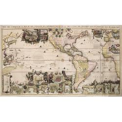
Carte Très Curieuse De La Mer Du Sud Contenant Des Remarques Nouvelles Et Tres Utiles Non Seulement Sur Les Ports et Isles de Cette Mer .
Based on de Fer's wall map of 1713. One map on 4 sheets, showing America in the middle with Europe on one side and the Pacific with Japan and China on the other. Top shee...
Date: Amsterdam, 1719
Selling price: ????
Please login to see price!
Sold in 2022
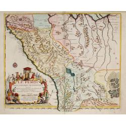
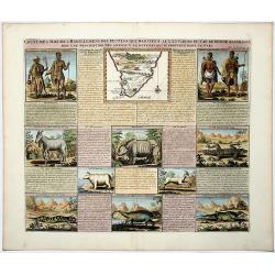
LE PEROU Dans l'Amérique Méridionale ?
Map of Peru including parts of present-day Ecuador, Bolivia, and Brazil. Cartographic elements include location of native American settlements, rivers, lakes, and wetland...
Date: Paris, 1719
Selling price: ????
Please login to see price!
Sold in 2009
Le Globe Celeste Representé En Deux Plans-Hemispheres. . .
Small double hemisphere celestial map based on the observations of Philippe de la Hire, a famous French astronomer. La Hire was one of the first to present the full celes...
Date: Paris, 1719
Selling price: ????
Please login to see price!
Sold in 2010
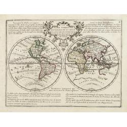
Le Globe Terrestre Representé en Deux Plans-Hemispheres..
Small double hemisphere world map featuring the Island of California and a Northwest Passage. There is little interior detail with only major nations named.Ter. de Jesso ...
Date: Paris, 1719
Selling price: ????
Please login to see price!
Sold
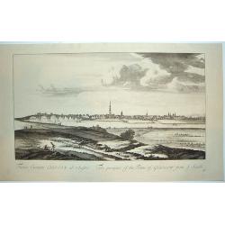
Facies Civitalis GLASCOAE...The prospect of the Town of Glasgow from the South
A beautifully engraved view of Glasgow, Scotland from a southern approach. Glasgow is dominated in the center by its cathedral. From the THEATRUM SCOTIAE, an important re...
Date: ca. 1719
Selling price: ????
Please login to see price!
Sold in 2011
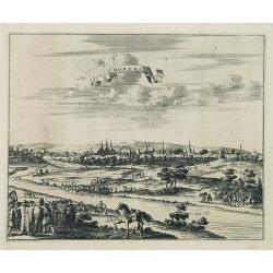
Moruma ville de la Tartarie Moscovite.
Decorative view of the town of Moruma, Russian city near the northern shore of the Caspian sea as seen from across the river Occa. Finely etched view after a drawing by N...
Date: Leiden, 1719
Selling price: ????
Please login to see price!
Sold in 2010
A New Map of the Kingdom of Denmark with the Dutchy of Holstein & c. According to the Newest Observations. . .
A finely detailed map of Denmark with lower Sweden by John Senex. Shows the rivers, marshes, lakes, cities, villages and mountains of the region. A beautiful, illustrated...
Date: London, 1719
Selling price: ????
Please login to see price!
Sold in 2010
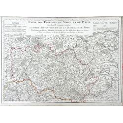
Carte des Provinces du Maine et du Perche dans Laquelle se trouve comprise La Partie Septentrionale De La Generalite De Tours
Finely detailed map of the province of Maine in northwestern France by Guillaume de L'Isle. Cities, villages, rivers, forests and mountains of the regions are depicted. T...
Date: Paris, 1719
Selling price: ????
Please login to see price!
Sold in 2010
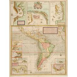
A New & Exact Map of the Coast, Countries and Islands within ye Limits of ye South Sea Company from ye River Aranoca to Terra del Fuego and from thence through ye South Sea, to ye North Part of California &c. . . . (Galapagos Islands!)
Very decorative map of the whole of South America extending north as far as the island California and Florida. Numerous insets including Acapulco, the Galapagos Islands, ...
Date: London, 1719
Selling price: ????
Please login to see price!
Sold in 2019
COUTUMES MOEURS & HABILLEMENS des PEUPLES QUI HABITENT AU ENVIRONS DU CAP DE BONNE ESPERANCE. . .
A decorative image of people & animals, with a map of southern Africa after Tachard. The people depicted are the Hottentots and the Namaquas of the Cape of Good Hope....
Date: Amsterdam, ca 1719
Selling price: ????
Please login to see price!
Sold in 2019
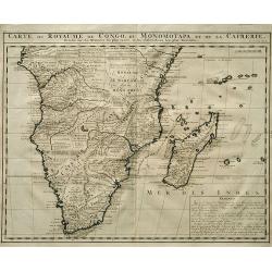
Carte Du Royaume De Congo Du Monomotapa et de la Cafrerie.
A copper engraved, detailed map of South Africa and Madagascar, with extensive notes regarding the local tribes, geography, mines, rivers, mountains, etc. One of the most...
Date: Amsterdam, ca 1719
Selling price: ????
Please login to see price!
Sold in 2019
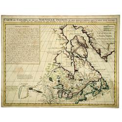
CARTE du CANADA ou de la NOUVELLE FRANCE, & Des decouvertes qui y ont ete faites. . .
Henri Chatelain's map of Canada follows in its rendering of the Great Lakes closely the de l'Isle model of 1703, but from an entirely new plate with a large panel of text...
Date: Amsterdam, 1719
Selling price: ????
Please login to see price!
Sold in 2020
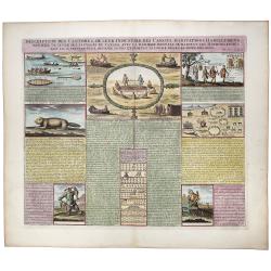
Inscription des Castors & De Leur Industrie des Canots Habitations Habillemens, maniere de vivre des sauvages du Canada. . .
A very unique sheet of various engravings concerning Native American customs and indigenous animals in North America. Includes a large view of an American buffalo and a g...
Date: Paris, ca 1719
Selling price: ????
Please login to see price!
Sold in 2020
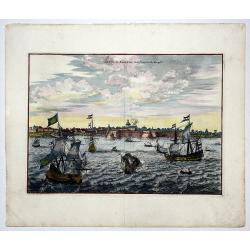
La Ville de SURATTE, dans l'Empire du Mogol.
A copper engraving of Suratte, an important former trade post of the VOC, seen here with some VOC ships and local vessels in the foreground. From Pieter van der Aa's in &...
Date: Leiden, 1719
Selling price: ????
Please login to see price!
Sold in 2020
![Carte Qui Contient la Mantere don't se Fait La Chasse des Boeufs Sauvages et des Elans, Le Grand Saut de la riviere de Niagar a la danse du Calumet. . .[NIAGARA FALLS..]](/uploads/cache/83653-250x250.jpg)
Carte Qui Contient la Mantere don't se Fait La Chasse des Boeufs Sauvages et des Elans, Le Grand Saut de la riviere de Niagar a la danse du Calumet. . .[NIAGARA FALLS..]
A beautiful colored chart showing the Natives of Canada. A very unique sheet of various engravings concerning Native American customs and indigenous animals in North Amer...
Date: Paris, 1719
Selling price: ????
Please login to see price!
Sold in 2020
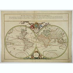
Mappe-Monde Geo-Hydrographique, ou Description Generale. . .
MAP OF THE WORLD DEDICATED TO THE KING. Large map of the world in two hemispheres, in a stereographic projection. California is connected to the mainland, rather than app...
Date: Paris, 1719
Selling price: ????
Please login to see price!
Sold in 2023
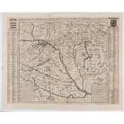
Nouvelle Carte De La Hongrie Divisee Selon ses Differents Etats, Avec une Chronologie De Ses Ducs et de ses Rois . . .
Detailed map of Hungary, extending to Bosnia, Slovenia, Temeswar, and the Saw River in the south to Moravia, and the Frontiers of Poland in the north, centered on the cou...
Date: Amsterdam, ca. 1719
Selling price: ????
Please login to see price!
Sold in 2020
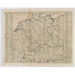
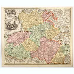
Nouvelle Carte de l'Alemagne avec des Tables des Branches de la Noblesse et les Lieux les Plus Remarquables de Leurs Residance.
Detailed map of Hungary, extending to Bosnia, Slovenia, Temeswar, and the Saw River in the south to Moravia, and the Frontiers of Poland in the north, centered on the cou...
Date: Amsterdam, ca. 1719
Selling price: ????
Please login to see price!
Sold in 2020
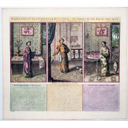
Habillement De L'Empereur De La Chine & Des Dames De Son Palais Avec Quel-ques Usages & Coutumes Observees en ce Pais.
A decorative and interesting folio sheet of engravings showing the costumes of the Chinese king and his wives in the Royal Palace. A finely engraved print from Chatelain'...
Date: Amsterdam, 1719
Selling price: ????
Please login to see price!
Sold in 2020
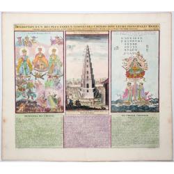
Description d' un des plus Fameux Temples des Chinois, avec leurs Principales Idoles telles que la Figure. . .
An interesting folio sheet with three engravings illustrating Chinese religion. The central engraving is of a pagoda in the Province of Fokien, which is flanked by two dr...
Date: Amsterdam 1719
Selling price: ????
Please login to see price!
Sold in 2020
La ville de Moscou, capitale de la Moscovie.
Decorative panoramic view of Moscow. Below the engraving a numbered key (1- 24) of the important buildings of the city. This well executed engraving was published in 1729...
Date: Leiden, 1719
Selling price: ????
Please login to see price!
Sold in 2021
![L'Amerique Septentrionale qui fait partie des Indes Occidentales . . . [California island]](/uploads/cache/85233-250x250.jpg)
L'Amerique Septentrionale qui fait partie des Indes Occidentales . . . [California island]
A fine example of the 1719 Chiquet's map of North America, with the accompanied related engraved French text sheet entitled "Description Abregé de l'Amerique Septen...
Date: Paris, 1719
Selling price: ????
Please login to see price!
Sold in 2021
![[Holy Land] Carte De La Terre Saint Divisee Dans Toutes Ses Parties Selon Le Nombre Des Tribus D'Israel . . .](/uploads/cache/85930-250x250.jpg)
[Holy Land] Carte De La Terre Saint Divisee Dans Toutes Ses Parties Selon Le Nombre Des Tribus D'Israel . . .
Detailed map of the Holy Land, from Chatelain's Monumental Atlas Historique et Methodique. Edited anno 1719. The map extends from Gaza to Sidon and identifies the 12 Tri...
Date: Amsterdam, 1719
Selling price: ????
Please login to see price!
Sold in 2021
![[Lot of 5 maps] PERSIA - Carte la plus nouvelle et plus-exacte du Royaume de Perse](/uploads/cache/IMG_4837-250x250.jpg)
[Lot of 5 maps] PERSIA - Carte la plus nouvelle et plus-exacte du Royaume de Perse
[Lot of 5 maps of Persia] - Carte la plus nouvelle et plus-exacte du Royaume de Perse, avec ses Côtes, Villes Maritimes, tous les Pays qui en dependent, et ses Lieux...
Date: Leiden, 1719
Selling price: ????
Please login to see price!
Sold in 2023
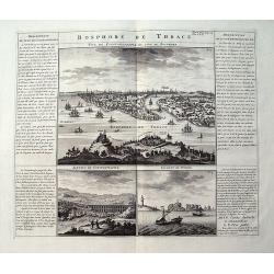
Bosphore de Thrace.
A large sheet with three views and extensive text in French. The main view is a bird's-eye view of Istanbul after De Bruyn. The two smaller views show an aqueduct near Is...
Date: Amsterdam, 1720
Selling price: ????
Please login to see price!
Sold in 2019
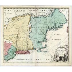
Nova Anglia Septentrionali Americae Implantata Anglorumque Coloniis Florentissima Geographice Exhibita.
A decorative map of the New York and New England region.
Date: Nuremberg, ca 1720
Selling price: ????
Please login to see price!
Sold in 2020
Exactissima Regni Scotiae Tabula. . .
This lovely copper engraved map includes all of Scotland, the Orkney Islands and the New Hebrides, here called the Westerne Iles of Scotland. The map is filled with minut...
Date: Amsterdam, 1720
Selling price: ????
Please login to see price!
Sold in 2021
Statuum totius Italiae. . . Siciliae Sardiniae. . .
Johann Baptist Homann's well-engraved map of Italy, Sardinia, Corsica, Malta and Sicily and the western edge of the Adriatic that has an excellent large decorative cartou...
Date: Nuremberg, 1720
Selling price: ????
Please login to see price!
Sold in 2020
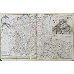
A New Map of Germany, Hungary, Transilvania & the Suisse Cantons,...
Large map of the German Empire, from Belgium until Belgrade, and from Danzig until Lyon. With some notes of local products, for example beer in Hamburg and salt made in T...
Date: London, ca. 1720
Selling price: ????
Please login to see price!
Sold in 2019
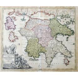
Peloponesus hodie Moreae Regnum...
Large scale map of the Peloponnese, the mainland in the north, and surrounding islands, including Zakynthos and Cephalonia. Shows many details and names, also some notes ...
Date: Nuremberg, ca. 1720
Selling price: ????
Please login to see price!
Sold in 2019
Nouvelle Carte de l' Amerique Septentrionale Dressee sur les plus Nouvelles Observations de Messieurs de l' Academie. . .
A superb map of North America with well developed cartography in the Great Lakes and Mississippi River.It takes in all of Central America and the West Indies. The English...
Date: Amsterdam, 1720
Selling price: ????
Please login to see price!
Sold in 2020
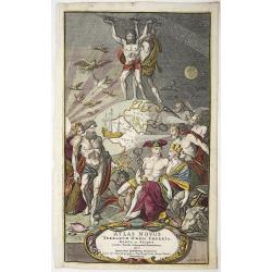
Atlas Novus Terrarum Orbis Imperia Regna et Status exactis Tabulis Geographice demonstrans . . .
Highly decorative title page, from Homann’s "Atlas Novus" engraved by Caspar Luycken, published in Nuremberg 1720. It shows in the middle, the globe focused o...
Date: Nurenberg, 1720
Selling price: ????
Please login to see price!
Sold in 2020
La Ville de Middelbourg.
A bird’s eye view of Middelbourg in the Netherlands, by Jacobus Harrewijn in 1720. Jacobus Harrewijn ( 1660–1727) was an engraver who was mostly active in the Souther...
Date: Brussels, 1720
Selling price: ????
Please login to see price!
Sold in 2020
La Ville de Harlem.
A bird’s eye view of Harlem in the Netherlands, by Jacobus Harrewijn in 1720. Jacobus Harrewijn (1660 – 1727) was an engraver who was mostly active in the Southern Ne...
Date: Brussels, 1720
Selling price: ????
Please login to see price!
Sold in 2020
![[Spain & Portugal] Hispania ex Archetypo Roderici Mendez Sylvae et variis Relationibus et Chartis manuscriptis et impressis huius Regni rectificatis per Observationes Sociorum Academiae Scientiarum quae est Parisiis.](/uploads/cache/1151518-250x250.jpg)
[Spain & Portugal] Hispania ex Archetypo Roderici Mendez Sylvae et variis Relationibus et Chartis manuscriptis et impressis huius Regni rectificatis per Observationes Sociorum Academiae Scientiarum quae est Parisiis.
Engraved map with original hand coloring 49.5 x 57 cm. (sheet size 53 x 62 cm.).
Date: Augsburg, 1720
Selling price: ????
Please login to see price!
Sold in 2020
Regni Daniae- in quo sunt Ducatus Holsatia et Slesvicum Insulae Danicae provinciae Iutia Scania Bleringia.
Original hand-colored engraved map. (sheet size 53 x 62 cm.)
Date: Nuremberg, 1720
Selling price: ????
Please login to see price!
Sold in 2020
Africa - Maurô percussa Oceanô, Niloque admota tepenti.
A very decorative large format map of Africa by Gerard Valk (1651-1726) and Leonardo Valk (1675-1755) published between 1705-1710. Title in an uncolored yet very ornate c...
Date: Amsterdam, 1720
Selling price: ????
Please login to see price!
Sold in 2020
Theatrum belli sive novissima tabula maxima pars Danubii et Hungaria cum alis regnis Graecia, Morea,Archipielago Insula
Engraved map with original hand coloring showing Greece and eastern part of the Mediterranean.
Date: Augsburg 1720
Selling price: ????
Please login to see price!
Sold in 2020
Comitatus Hannoniae in quas quasque Castellanias Balliviatus. . .
This beautiful and detailed map, is centered on the Belgian city of Mons, and includes the towns of Doornick, Halle, Charleroy, Camerijk and Dounay. The larger towns are ...
Date: Nuremberg, ca 1720
Selling price: ????
Please login to see price!
Sold in 2021
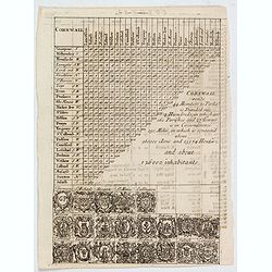
Cornwall.
A triangular distance table of Cornwall, with 21 sets of arms of the county and towns including Truro, St Ives & Fowey, with some statistics about the county. Publish...
Date: London, 1720
Selling price: ????
Please login to see price!
Sold in 2021
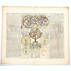
Premiere carte pour l'Introduction a l'histoire du monde, ou l'on remarque la Sphere, le Globe Celeste. . ..
Featuring a small double hemisphere world map, showing California as an island, North and South Polar celestial hemispheres, an Armillary Sphere, below with smaller circu...
Date: Amsterdam, 1720
Selling price: ????
Please login to see price!
Sold in 2020