Browse Listings
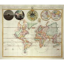
Carte Generale du Monde..
Pierre Mortier's unique world map drawn on Mercator's projection with California as an Island and the Detroit d'Anian connected by dotted lines through the Northwest Pass...
Date: Amsterdam 1700
Selling price: ????
Please login to see price!
Sold
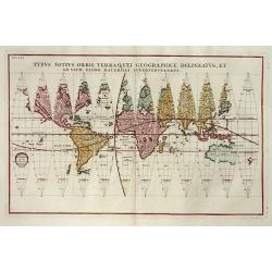
Typus Totius Orbis Terraquei Geographice
Finely engraved set of globe gores. This is one of eleven world maps, which appeared in the Novus Atlas that was published between 1702 and 1710. CALIFORNIA IS AN ISLAND,...
Date: Munich c.1700
Selling price: ????
Please login to see price!
Sold
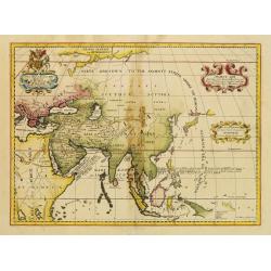
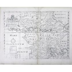
Ancient Asia.
Map of ancient Asia engraved by Michael Burghers of Oxford University. Dedicated to the Duke of Gloucester.With several interesting legends, a legend in the vicinity of t...
Date: Oxford, 1700
Selling price: ????
Please login to see price!
Sold in 2014
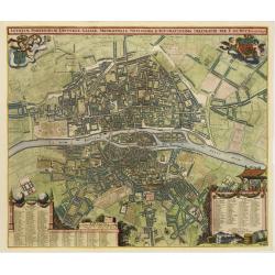
Lutetiae Parisiorum Universae Galliae Metropolis Novissima & Accuratissima Delineatio per F. de Wit cum Privilegio.
Bird-eye view of Paris, with key to the different locations. De Wit used the copper plate of Joannes de Ram from 1690. The plan was made after Jouvin de Rochefort and sho...
Date: Amsterdam, c. 1700
Selling price: ????
Please login to see price!
Sold
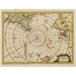
Terres ANTARCTIQUES.
Delightful map of the South Pole, including southern tips of Africa and America as well as drafts of Australia, New Zealand and some Islands of Polynesia.
Date: Amsterdam 1700
Selling price: ????
Please login to see price!
Sold
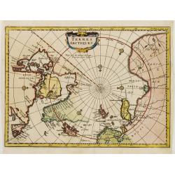
Terres ARCTIQUES.
Delightful map of the North Pole, including Greenland, Scandinavia, Canada and Russia.
Date: Amsterdam 1700
Selling price: ????
Please login to see price!
Sold
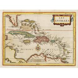
Les ANTILLES.
Attractive map of the Greater and Lesser Antilles.
Date: Amsterdam 1700
Selling price: ????
Please login to see price!
Sold
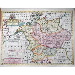
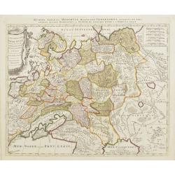
A New Map of Antient Germany, Rhaetia, Vindelicia, and Noricum...
Interesting map of central Europe during ancient times. Extending from Denmark to northern Italy. Includes Germany, the Netherlands, Poland, Austria,... From "A N...
Date: Oxford, c1700
Selling price: ????
Please login to see price!
Sold in 2013
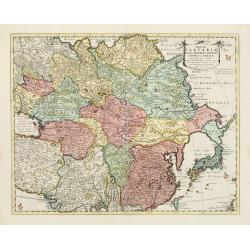
Magnae Tartariae Magni Mogolis Imperii Japoniae et Chinae..
The map stretches from the Caspian Sea in the West to Formosa and Japan in the East. Korea rightly correctly depicted as a peninsula. With an over-sized Taiwan. It has be...
Date: London, 1700
Selling price: ????
Please login to see price!
Sold in 2009
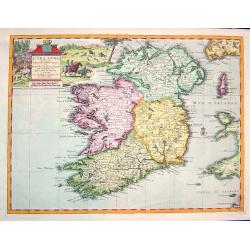
L''irelande suivant les nouvelles observations
A beautifully rendered and sought after map of Ireland. The cartouche depicts a pastoral scene with horsemen, hunters and various domesticated and wild animals. A very de...
Date: Leiden, ca. 1700
Selling price: ????
Please login to see price!
Sold in 2008
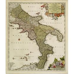
Regnum Neapolis..
Uncommon re-issue of this fine map of the southern part of Italy. In top putti holding the 12 coats of arms. Lower right scale and putti holding coat of arms of the town ...
Date: Amsterdam, 1700
Selling price: ????
Please login to see price!
Sold in 2008
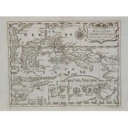
![[2 charts] Accuratissima Occidentalioris Districtus Maris Mediterranei.. / Accuratissima Orientalis Districtus Maris Mediterranei..](/uploads/cache/09561-250x250.jpg)
[2 charts] Accuratissima Occidentalioris Districtus Maris Mediterranei.. / Accuratissima Orientalis Districtus Maris Mediterranei..
Rare issue of Justus Danckert's attractive 2-sheet map of Mediterranean sea. Decorative title cartouche lower left hand corner.
Date: Amsterdam, 1700
Selling price: ????
Please login to see price!
Sold
Carte générale du monde, ou description du monde Terrestre & Aquatique.
Beautiful world map from a Dutch Bible. The map is drawn on Mercator's projection with CALIFORNIA AS AN ISLAND and the Detroit d'Anian connected by dotted lines through t...
Date: Amsterdam, 1700
Selling price: ????
Please login to see price!
Sold
La Russie Blanche ou Muscovie
Uncommon map of European Russia, including Ukraine.
Date: Amsterdam, 1700
Selling price: ????
Please login to see price!
Sold
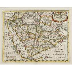
't Steenachtige, Woest, en Gelukkig Arabien.
An attractive map of the Arabian Peninsula from a Dutch text edition. Engraved by A.de Winter.
Date: Amsterdam, 1700
Selling price: ????
Please login to see price!
Sold
ORBIS PER CREATIONEM INSTITUTUS; ORBIS PER DILUVIUM DESTITIUTUS
Attractive and rare map centered on the Garden Eden. Shows the Near East with Holy Land Israel, Syria, Jordania, Palestine, Arabia, Yemen, the Emirates, Egypt, Turkey, C...
Date: Amsterdam, c 1700
Selling price: ????
Please login to see price!
Sold in 2008
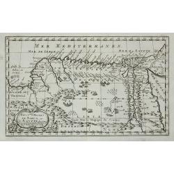
Persia sive Sophorum regnum cum Armenia Assyria Mesopotamia et Babylonia.
Uncommon map of the Near East, including Cyprus, Holy Land, Armenia, etc.
Date: Amsterdam, 1700
Selling price: ????
Please login to see price!
Sold in 2008
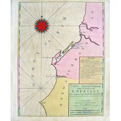
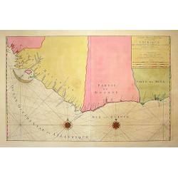
Carte Particuliere des costes de l'Afrique qui comprend une partie de Congo
Beautiful chart from Mortier's edition of Le Neptune François. Covers the region near the Congo River including Loanda, Ponta dos Palmeirinha, and Cabo Ledo. A text cart...
Date: Amsterdam, c1700
Selling price: ????
Please login to see price!
Sold in 2008
![[ Lago di Sabaudia / Baia d'Argento ] Manuscript map on paper.](/uploads/cache/30281-250x250.jpg)
[ Lago di Sabaudia / Baia d'Argento ] Manuscript map on paper.
A large and decorative manuscript map on paper, oriented west to the top. In the center "Lago di Santa Maria", which is presently called "Baia D'Argento&qu...
Date: Italy, c.1700
Selling price: ????
Please login to see price!
Sold in 2011
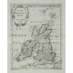
Isles Britanniques.
A map of the British Isles from Description de tous l'Univers published by François Halma.
Date: Amsterdam, 1700
Selling price: ????
Please login to see price!
Sold in 2011
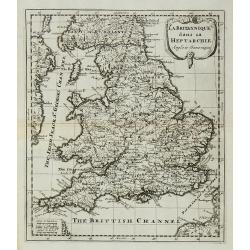
La Britannique dans sa Heptarchie ...
A map of the England from Description de tous l'Univers published by François Halma.
Date: Amsterdam, 1700
Selling price: ????
Please login to see price!
Sold in 2011
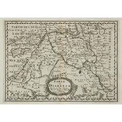
Sorie, et Diarbeck.
An attractive miniature prepared by N.Sanson. Covering the Syrian desert, Lebanon, and the mouth of the Tigris in the Persian Gulf. Including Babylon, Tripoli, Palestine,...
Date: Paris, c.1700
Selling price: ????
Please login to see price!
Sold in 2011
Royaume et desert de Barca, et Aegypte ...
An attractive miniature map of Egypt prepared by N.Sanson. Engraved by A.de Winter.
Date: Paris, c.1700
Selling price: ????
Please login to see price!
Sold in 2011
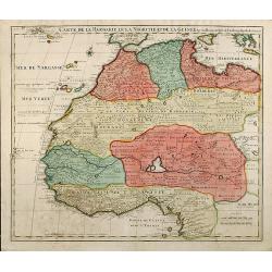
Carte De La Barbarie Le La Nigritie Et De La Guinee
Detailed hand colored copper engraving showing North West Africa from Mediterranean Sea to Gulf of Guinea including Canary Island.
Date: 1700
Selling price: ????
Please login to see price!
Sold in 2009
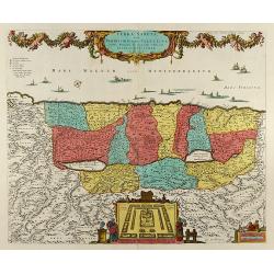
Terra Sancta, sive Promissionis, olim Palestina Recens Delineata, et in Lucem Edita per Nicolaum Visscher Anno 1659
Beautiful hand color copper engraved map of Palestine by N. Visscher issued by P. Schenk in Amsterdam. Oriented to the West. With beautiful cartouches, several ships, a p...
Date: Amsterdam, 1700
Selling price: ????
Please login to see price!
Sold in 2008
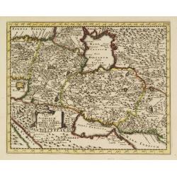
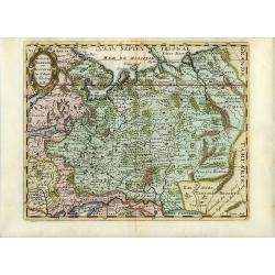
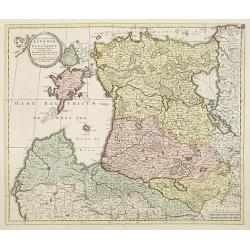
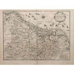
Etats de la Couronne de Pologne.
Detailed map covering the region of present-day Poland, Lithuania, Belarus and Ukraine. Engraved by Anthony d'Winter.
Date: Amsterdam, 1700
Selling price: ????
Please login to see price!
Sold in 2008
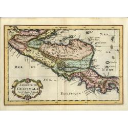
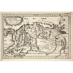
Audience de Guatimala
Nice map that illustrates the region from the Yucatan to the Gulf of Panama. It is nicely detailed, although much of the topography is still incorrect. Lago de Nicaragua ...
Date: Amsterdam, 1700
Selling price: ????
Please login to see price!
Sold in 2008
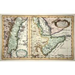
Le Zanguebar Tiree de Sanut &c. / Partie du Zanguebar ou Sont les Costes d'Ajan et d'Abix &c.
This attractive map, in two parts, covers the east coast of Africa from Mozambique to the Red Sea showing the prosperous trading ports. Each map has a decorative title ca...
Date: Amsterdam, 1700
Selling price: ????
Please login to see price!
Sold in 2008
Russie Blanche ou Moscovie
Attractive copper engraved map of European Russia showing its political divisions, major topographical features, cities and towns. It is embellished with a strapwork titl...
Date: Amsterdam, 1700
Selling price: ????
Please login to see price!
Sold in 2008
Nieuwe en Naauwkeurige Paskaart van de Guineese, Goud, Tand en Slave Kust ? - Nouvelle carte des Cotes de Guinée, d\'Or, de Dent et des Esclaves. . .
Uncommon sea chart of Africa\'s Gold coast (Cap Verde) to Cape of Good Hope.
Date: Amsterdam, 1700
Selling price: ????
Please login to see price!
Sold in 2008
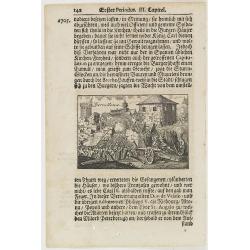
Barcellona.
A page of printed text in German with an engraving of an attack on the city of Barcelona.
Date: Germany, ca.1700
Selling price: ????
Please login to see price!
Sold in 2009
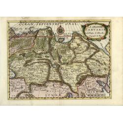
La Grande Tartarie
Attractive map of Siberia, northern China, and Korea, which is shown here as an island. The cities, mountains, forests and rivers are well-detailed. Siberia still reflect...
Date: Amsterdam, 1700
Selling price: ????
Please login to see price!
Sold in 2008
Tartaria sive Magni Chami Imperium
Being one of the most remote regions of Asia, it was among the last to be properly explored and mapped. This map combines the knowledge obtained by the English and Dutch ...
Date: Amsterdam, 1700
Selling price: ????
Please login to see price!
Sold in 2009
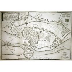
COPENHAGUE Ville Capitale du Royaume de Dannemarq...
Very detailed plan of Copenhagen with a letter key (A-F) identifying important buildings. Shows the city and surrounding area with great detail such as the fortifications...
Date: Paris, 1700
Selling price: ????
Please login to see price!
Sold in 2010
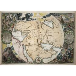
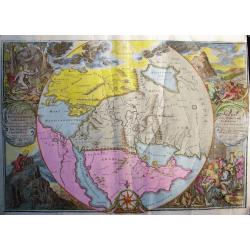
Orbis Per Creationem Institutus.
This is a very unusual map depicting the region from Asia Minor to India and including all of the Arabian Peninsula within a circle. The Garden of Eden is prominently dis...
Date: Amsterdam, 1700
Selling price: ????
Please login to see price!
Sold in 2009
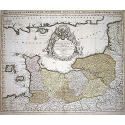
Le Duché et Gouvernement du Normandie diviseé...
Large scale map of Northern France, with excellent detail of La Manche. Latin title "Nova ducatus et praefecturae normanniae tabula, ad usum serenissimi burgundi...
Date: Amsterdam, ca1700
Selling price: ????
Please login to see price!
Sold in 2009
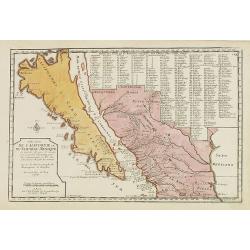
Cette Carte de Californie et du Nouveau Mexique ?
A most important map, identifying by numerical code some 314 places in New Mexico, and showing in detail California as an island, although based on Sanson's monumental ma...
Date: Paris, 1700
Selling price: ????
Please login to see price!
Sold in 2009
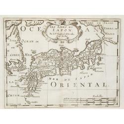
Les Isles du Iapon.
Date: Amsterdam, 1700
Selling price: ????
Please login to see price!
Sold in 2009
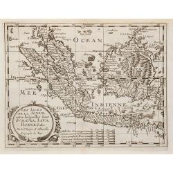
Les Isles de la Sonde entre lesquelles sont Sumatra, Java ?
The title is within a decorative cartouche flanked by swags of fruit. The islands of Sumatra, Java and Borneo in full, together with part of those adjacent and includes t...
Date: Amsterdam, 1700
Selling price: ????
Please login to see price!
Sold in 2010
Les Isles Molucques, Celebes, Gilolo, &c. ?
Shows the islands east of Borneo, up to and including New Guinea. From a pocket-atlas published by F. Halma.
Date: Amsterdam, 1700
Selling price: ????
Please login to see price!
Sold in 2009
Accuratissima Ducatus Silesiae eique Regnum Bohemiae..
Rare issue of Theodorus Danckert's attractive map of part of Poland, centered on Breslau.Decorative title cartouche upper right hand corner.
Date: Amsterdam, 1700
Selling price: ????
Please login to see price!
Sold in 2013
Perigrinatie ofte Veertich-Jarige Reyse der Kinderen Israels, ...
Bible map of the Holy Land.
Date: Amsterdam, ca.1700
Selling price: ????
Please login to see price!
Sold in 2010
Carte Particuliere des costes de l'Afrique qui comprend une partie della Guinée et Partie de Mina...
Beautiful chart from Mortier's rare edition of 'Le Neptune François.' Covers the region from today's Sierra Leone until the Cape Coast area in Ghana. With numerous towns...
Date: Amsterdam, c1700
Selling price: ????
Please login to see price!
Sold in 2009
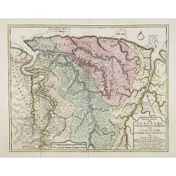
Nieuwe kaart van Suriname vertonende de stromen en land-streken van Suriname, Comowini, Cottica en Marawini, gelegen in Zuid America op de kusten van Caribana. . .
Decorative full color example of Ottens map of Suriname. Detailed map of the northeast part of Suriname between Paramaribo, with fort Zeelandia, and Mana. Along the Surin...
Date: Amsterdam, ca. 1700
Selling price: ????
Please login to see price!
Sold
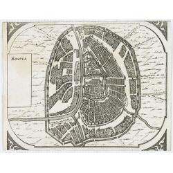
Moscua.
Very rare bird's-eye view of Moscow, intended to be used for a "carte à figures" wall-map, published by Frederick de Wit, to accompany the his wall map of Euro...
Date: Amsterdam, 1672-1700
Selling price: ????
Please login to see price!
Sold in 2009
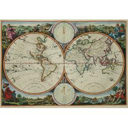
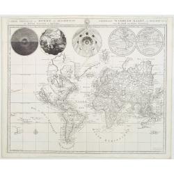
Korte Beschrijvinge van de Lantschappen des WERELTS
Double hemisphere world map. Surrounded by allegorical representations of the continents, based on Visscher. Australia is partially mapped and there is only a hint of New...
Date: Amsterdam, c. 1700
Selling price: ????
Please login to see price!
Sold in 2009
Terre Ferme, Nouveau Royaume de Grenade ?
Fine map of Colombia, Venezuela and the islands of Curaçua, Aruba, Bonaire, etc ... Prepared by N. Sanson. Engraved by A. de Winter.
Date: Amsterdam, 1700
Selling price: ????
Please login to see price!
Sold in 2009

Frontispiece of the sixth part of the Civitates, colored by Anna Beek.
Frontispiece of the sixth part of the Civitates, here implicated, colored and heightened with gold by Mrs. Anna Beek. The engraver and publisher of prints, Mrs. Anna Beek...
Date: The Hague, 1700
Selling price: ????
Please login to see price!
Sold in 2012
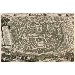
De Heylige wytvermaerde stad Jerusalem eerst genaemt Salem.
Decorative cityplan of Jerusalem.
Date: Amsterdam, c.1700
Selling price: ????
Please login to see price!
Sold in 2010
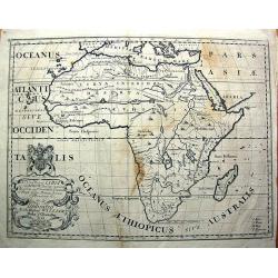
A New Map of Libya or old Africk. . . .
Curious map of ancient Africa, showing the entire continent and Madagascar. With two sources of the Nile. It shows the classic source in the twin lakes of Zaire and Zafla...
Date: Oxford, c1700
Selling price: ????
Please login to see price!
Sold in 2011
Extrema Americae Versus Boream, ubi Terra Nova Nova Francia, Adiacentiaq.
Rare issue by Pierre Mortier, identical to 1662's map by J. Blaeu. Later reissued by J. Covens also.The map is in a strictly contemporary coloring and of the highest leve...
Date: Amsterdam, c.1700
Selling price: ????
Please login to see price!
Sold in 2014

Audience de Mexico.
From a pocket atlas called "Description de tout l'Univers" published by F. Halma. Engraved by A. de Winter.
Date: Amsterdam, 1700
Selling price: ????
Please login to see price!
Sold in 2011
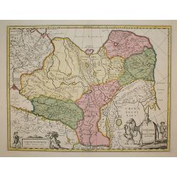
ucatuum Livonia et Curlandiae Novissima Tabula in Quibus sunt Estonia Litlandia et. . .
Nice engraved map of Estonia and Lithuania and parts of Russia. Decorative title cartouche supported by cherubs in the upper left corner.Uncommon issue published by Joach...
Date: Amsterdam, 1700
Selling price: ????
Please login to see price!
Sold in 2010
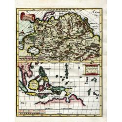
Utrivso Tartariae & Insularum Indicaru.
Two maps on one sheet. The one on top showing northern Russia in great detail, with many mountains, woods, rivers, and towns shown. The map on the bottom shows Indonesia ...
Date: Munich, c1700
Selling price: ????
Please login to see price!
Sold in 2010
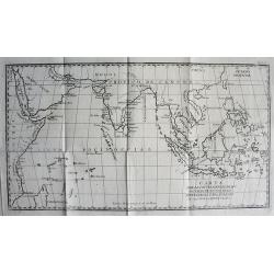
CARTA PARA LA INTELIGENCIA DE LOS ESTABLECIMIENTOS DE LOS PORTUGUESES Y HOLANDESES EN LAS INDIAS ORIENTALES.
SCARCE map of the Indian Ocean and South East Asia. Extends from the East African Coast, Madagascar, and Arabia to Formosa (Taiwan), the Philippines, and New Guinea. Fa...
Date: ca. 1700
Selling price: ????
Please login to see price!
Sold in 2010
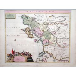
Epirus Pyrrhi Patria / Novantiqua Epirus quae hodie Albania.
A Sanson map of Greece and Albania published by the Covens and Mortier firm.
Date: Amsterdam, 1700
Selling price: ????
Please login to see price!
Sold in 2010
Land Tafel darinnen die gegendt des Paradijs das land Canaan. . .
Beautiful and rare map showing the Holy Land, Syria, Cyprus, Iran, Iraq, etc. With inset portraits showing Adam and Eve. Scale in lower part, with little cartouche giving...
Date: Germany, ca. 1700
Selling price: ????
Please login to see price!
Sold in 2010
![[No title] La mer noire, autrefois Pont-Euxin. . .](/uploads/cache/28941-250x250.jpg)
[No title] La mer noire, autrefois Pont-Euxin. . .
Maps of the region Black sea, showing the cities of Constantinople, Heraclee, Kafa. . . From his 'Atlas Curieux'.
Date: Paris, 1700
Selling price: ????
Please login to see price!
Sold in 2010
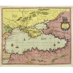
Ponti euxini cum periplus auctore N.Sanson.
A very rare map of the Black Sea area prepared by Nicolas Sanson. The map is in stunning full colors.
Date: Amsterdam, 1700
Selling price: ????
Please login to see price!
Sold in 2010
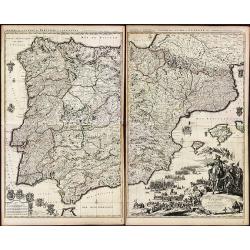
Theatre de la Guerre en Espagne et en Portugal.
A exceptional detailed wall map of Spain and Portugal with a huge beautiful designed title cartouche. Printed from 4 plates, two each already joined. Size of both sheets ...
Date: Amsterdam, 1700
Selling price: ????
Please login to see price!
Sold in 2010
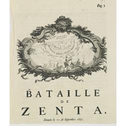
Bataille de Zenta, Donnée le 11 de Septembre 1697.
Decorative etching of the siege by Prince Eugène de Savoie of Zenta in Serbia by the French on 11 September 1697. The town, river Tisza and the Ottoman troupes are shown...
Date: Amsterdam, ca. 1700
Selling price: ????
Please login to see price!
Sold in 2010
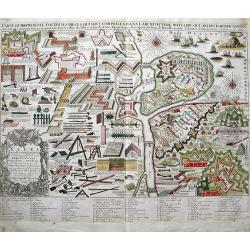
CARTE QUI REPRESENTE TOUTES LES PIECES QUI SONT COMPRISE DANS L'ARCHITECTURE MILITAIRE OU L'ART DES FORTIFICATIONS...
Attractive copper-engraved print of military objects, weapons, cannons, fortifications, buildings, ships, tools, etc. Includes an extensive key with more than 84 descript...
Date: Amsterdam, c1700
Selling price: ????
Please login to see price!
Sold in 2010
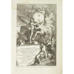
Title page from '"Atlas François'.
Decorative title page with a cetain holding the title : Atlas François contenant les cartes géographiques ... les Empires, Monarchies, Royaumes et Estats de l'Europe, ...
Date: Paris, 1700
Selling price: ????
Please login to see price!
Sold in 2010
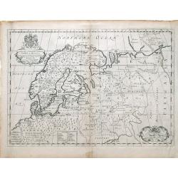
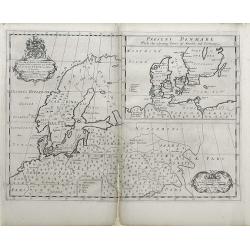
A New Map of Denmark, Norway, Sweden, & Moscovy shewing their present general divisions, chief cities or towns, rivers and mountains & c.
Fine map of Scandinavia and Russia from 1700, dedicated to the Duke of Glocester. Cartouche with English coat of arms is in the upper left corner.
Date: London, 1700
Selling price: ????
Please login to see price!
Sold in 2010
Novus XVII Inferioris Germania, Proviniarum Typus.
Finely detailed map of Belgium and Holland from Merian's Topographia Germania Inferioris. Ships, sea monsters, and a pretty compass rose are depicted in the North Sea.
Date: Frankfurt, 1700
Selling price: ????
Please login to see price!
Sold in 2010
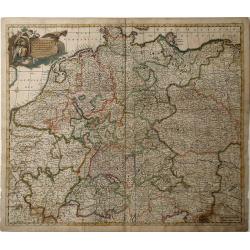
Nova et Prae Caeteris Alis Correcta Germaniae Tubula Comprehendens Accuratam X. Circulorum, Bohemiae, Regni, AC Univerfae Helvetia Defcriptionem, Cum Divifione in Caeterais Partes.
An overall map of Western Europe by Frederick De Witt which includes Saxony, France, Poland, Bohemia, and parts of Northern Italy down to the Venetian Gulf. Major cities ...
Date: Amsterdam, cira 1700
Selling price: ????
Please login to see price!
Sold in 2010
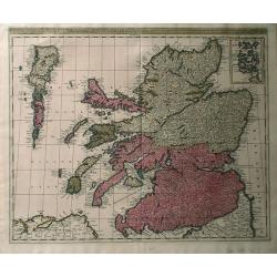
Regnun Scotiae, feu pars Septent: Magnae Brittanniae, divifa in Scotiam Septent: et Auftralem, porro autem in Comit: Rossiam Maraviam, Praefect: Lavdoniam, Renefroviam et Arandum, una cum Infulis Ebuda Occident: et Orient: Mula, Jura et Ila.
A wonderfully detailed map of Scotland and the islands off its coast by Gerard and Leonard Valk. This map includes major cities, rivers and towns, and at the top right in...
Date: Amsterdam, 1700
Selling price: ????
Please login to see price!
Sold in 2010
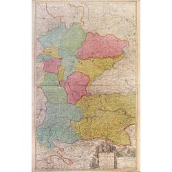
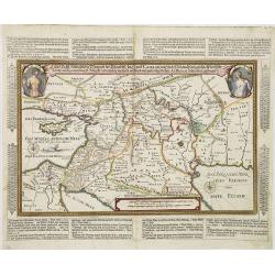
Theatre de la Guerre en Austriche, Baviere, Souabe, Le Tirol. Et le Pays aux Environs.
Colorful map of the Kingdom of Bohemia located in central Europe, present day-Czech Republic and Austria, until its dissolution in 1806. Different regions of Bohemia are ...
Date: Amsterdam, c. 1700
Selling price: ????
Please login to see price!
Sold in 2010
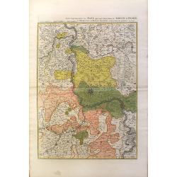
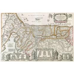
Partie Septentrionalo Des Pats qui sont situez entre le Rhein, la Saare, la Moselle, et la Basse Alsace.
This vibrantly colorful map focuses on the Rhine River region in southern Germany and its tributaries, extending into France. The Rhine is illustrated in the center of th...
Date: Amsterdam, c. 1700
Selling price: ????
Please login to see price!
Sold in 2010
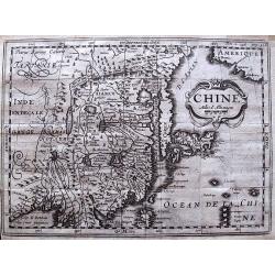
Chine.
Scarce and interesting map of China printed from a reworked Cloppenburgh plate. Latin names and hachuring have been burnished from the plate and the original title “Chi...
Date: Amsterdam, 1700
Selling price: ????
Please login to see price!
Sold in 2012
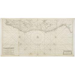
![[No tittle] The Sea Coasts south of England and Brittany in France.](/uploads/cache/29447-250x250.jpg)
[No tittle] The Sea Coasts south of England and Brittany in France.
Detailed of the Channel with Cornwall and Brittany.
Date: London, c.1700
Selling price: ????
Please login to see price!
Sold in 2011
A New Map of Ancient Scandinavia together with as much more of y Northern Part of Ancient Europe as Anvers to Present Denmark & Moscovia
Map of Scandinavia, with an inset map of Denmark, from Edward Wells' "A New Sett Of Mapps Of Ancient And Present Geography ..." Wells was a teacher of mathemati...
Date: Oxford, 1700
Selling price: ????
Please login to see price!
Sold in 2010
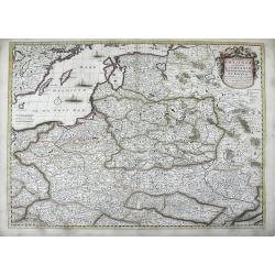
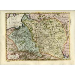
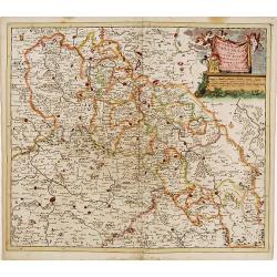
Regni Poloniae et Ducatus Lithuaniae, Volinae, Podoliae, Ucraniae, Prussiae et Curlandiae . . .
Finely detailed map of the Baltic Sea region, including the regions of Poland, Hungary, Prussia, Ukraine, eastern Germany, and southwest Sweden by Frederick de Wit. Villa...
Date: Amsterdam, c.1700
Selling price: ????
Please login to see price!
Sold in 2010
A New Map of Antient Thrace: as also Of the Northern Parts of Old Greece, Macedonia and Thessalia Dedicated to His Highness William Ducke of Glocester.
Map of Thrace, a historical and geographical region in Southeast Europe, currently the area of Northern Greece and Bulgaria, including parts of Macedonia and Thesalia (no...
Date: Oxford, c. 1700
Selling price: ????
Please login to see price!
Sold in 2010
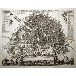
AMSTELODAMI VETERIS ET NOVISSIMAE URBIS ACCURATISSIMA DELINEATIO
SCARCE and unknown city plan of Amsterdam by or after (?) Visscher. Smaller edition of Visschers famous map of Amsterdam from ca. 1678. Embellished with numerous figures...
Date: ca. 1700
Selling price: ????
Please login to see price!
Sold in 2011
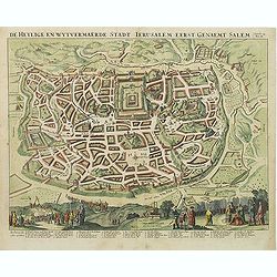
De Heylige en Wytvermaerde Stadt Jerusalem eerst genaemt Salem Genesis 14 Vers 18.
Very attractive bird's-eye view of Jerusalem, showing the city laid out in blocksIn the foreground are shown Christ on the cross at Mount Calvary, and Solomon at Mount Gi...
Date: Amsterdam, c. 1700
Selling price: ????
Please login to see price!
Sold in 2011
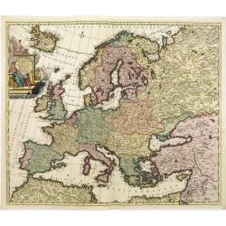
Accuratissima Europae tabula multis locis correcta. . .
Uncommon map of Europe with fine title cartouche, likely after a design by Philip Tideman.
Date: Amsterdam, c.1700
Selling price: ????
Please login to see price!
Sold in 2011
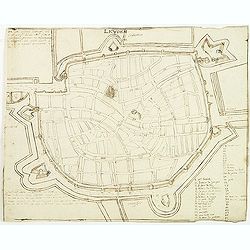
Leyden.
Manuscript fortification town-plan of Leiden, as it was at about 1670. With a numbered key (1-46) pointing to the important buildings, streets and canals in town.
Date: France, ca. 1670-1700
Selling price: ????
Please login to see price!
Sold in 2013
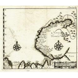
Nova Zemla.
Unknown copper-engraved map of Nowaja Semlja (Новая Земля). Shows t...
Date: ca.1700
Selling price: ????
Please login to see price!
Sold in 2011
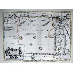
PATRIARCHATUS ALEXANDRINI...
Very interesting copper engraved map of Egypt and Lybia.Shows the Nile river with numerous ancient place names and some more cities along the coast are named.Mystical lar...
Date: Amsterdam, ca. 1700
Selling price: ????
Please login to see price!
Sold in 2011