Browse Listings in Polar maps
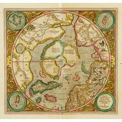
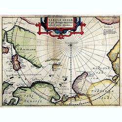
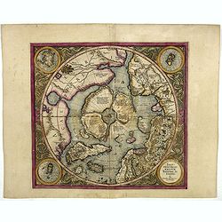
SEPTENTRIONALIUM Terrarum descriptio. Per Gerardum Mercatore
State 2. This is the first map devoted to the Arctic, a hemispherical one on a North Polar projection with an attractive floral design surrounding it. In the corners are ...
Place & Date: Amsterdam 1609
Selling price: $2400
Sold
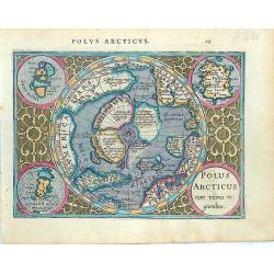
Polus Arcticus cum vicinis regionibus.
Early map of the North Polar regions. Shows the mythical land masses near the pole, the clearly navigable NW and NE passages, a massive California and marvelous detail in...
Place & Date: Amsterdam, 1610
Selling price: $450
Sold in 2014
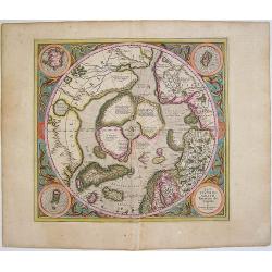
Septentrionalium Terrarum descriptio
This influential map was the first separately printed map devoted to the Arctic. The hemisphere is surrounded by a floral design with four roundels in each corner. These ...
Place & Date: Amsterdam, 1611
Selling price: $1150
Sold in 2011
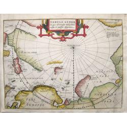
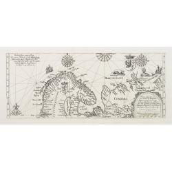
Tabula Geogr. in qua admirandae navigationis cursus et recursus designatur.
First state of a very early and scarce map of the North Pole and Arctic regions showing recent discoveries including the voyage of Jan Willem Barentsz on his quest to fin...
Place & Date: Amsterdam, 1611
Selling price: $850
Sold in 2016
Tabula Septentrionalis Russiae, Samoithiae et Tingosiae..
A very rare map was published by Hessel Geritsz. describing the northern passage according to Isaac Massa. Hessel Gerritsz. published his Beschryvinghe vander Samoyeden L...
Place & Date: Amsterdam 1613
Selling price: $1250
Sold
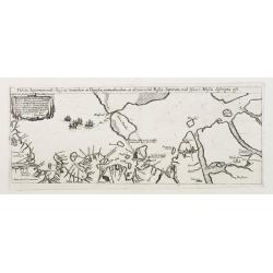
Vera delineatio totius tractus ex Hollandia.. Lintschottani.
A very rare map was published by Hessel Geritsz. describing Jan Huijgen van Linschoten's voyage of 1594 -95 in order to find a north passage to the East.Hessel Gerritsz. ...
Place & Date: Amsterdam 1613
Selling price: $850
Sold
Tabula Geogr. In qua admirandae navigatonis..
A finely engraved map by Jodocus Hondius with coastline details of northern Europe, Greenland, Frisland, Strait Anian with America pars. With the track of a Willem Barent...
Place & Date: Amsterdam, 1614
Selling price: $740
Sold in 2019
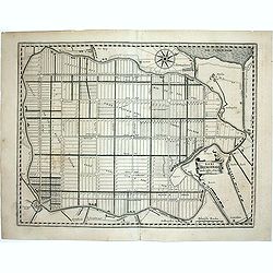
Agri Biemstrani Descriptio a L.I.S.
Detailed map of the polder Beemster in Noord Holland. Including the towns of Purmerend, De Ryp, Oudendijk, etc. The oldest area reclaimed from the sea in the Netherlands....
Place & Date: Amsterdam, 1617
Selling price: $250
Sold in 2011
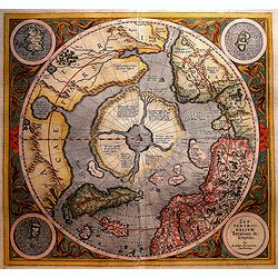
SEPTENTRIONALIUM Terrarum descriptio. Per Gerardum Mercatore
State 2. This is the first map devoted to the Arctic, a hemispherical one on a North Polar projection with an attractive floral design surrounding it. In the corners are ...
Place & Date: Amsterdam, 1623
Selling price: $1500
Sold in 2019
SEPTENTRIONALIUM Terrarum descriptio. Per Gerardum Mercatore
State 2. This is the first map devoted to the Arctic, a hemispherical one on a North Polar projection with an attractive floral design surrounding it. In the corners are ...
Place & Date: Amsterdam, 1623
Selling price: $2100
Sold in 2016