Browse Listings in Europe > Scandinavia > general
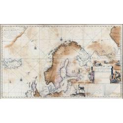
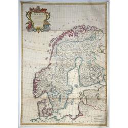
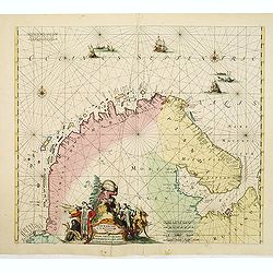
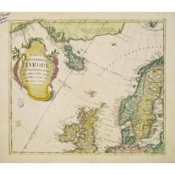
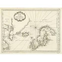
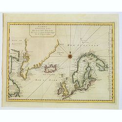
Nieuwe Paskaart Inhoudende t'Noorder deel van Europa sijnde seer Dienstigh voor de Groenlandse en Moscovise Scheepvaard.
A very large, exceptionally rare, early navigation chart of Scandinavia by van Keulen, with highly decorative hunting scenes. The chart is based on Mercator projection. G...
Place & Date: Amsterdam, 1701
Selling price: ????
Please login to see price!
Sold in 2022
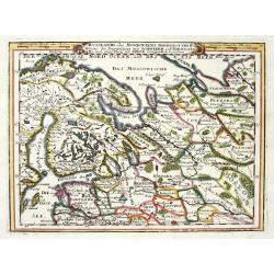
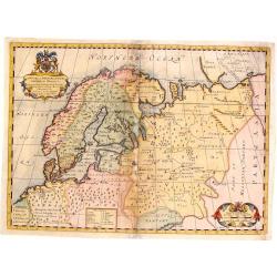
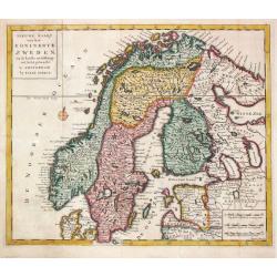
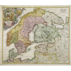
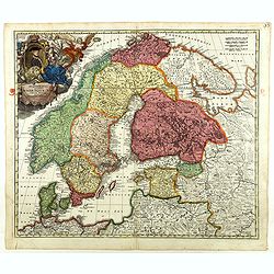
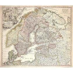
RUSSLANDS ODER MOSKOVIENS NORD-WEST THEIL...SCHWEDEN UND NORWEGEN...POLEN...
Very decorative map from Bodenehr's "Atlas curieux" published in Augsburg. The map shows parts of Norway, Sweden, Finland, the Baltic states and Russia in gre...
Place & Date: Augsburg c1704
Selling price: ????
Please login to see price!
Sold in 2009
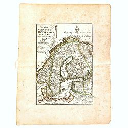
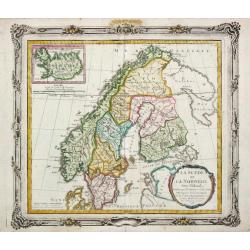
Suède, Norvège et Dannemarck.
An interesting small map of Scandinavia by Nicolas de Fer. From his rare "Petit et Nouveau Atlas". The first edition was published in 1697 and was republished i...
Place & Date: Paris, 1704
Selling price: ????
Please login to see price!
Sold in 2017
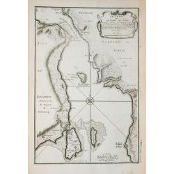
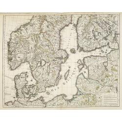
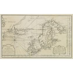
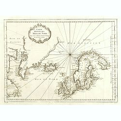
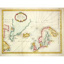
Le Sund ou Detroit du Sond.
Map of the Baltic sea, from "Atlas Curieux", printed in Paris.
Place & Date: Paris, 1705
Selling price: ????
Please login to see price!
Sold in 2012
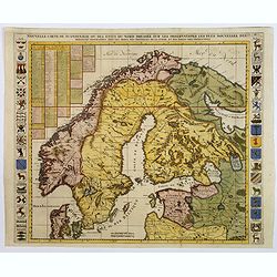
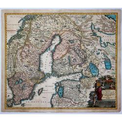
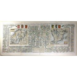
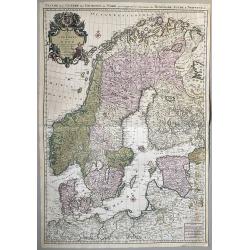
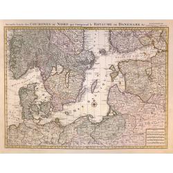
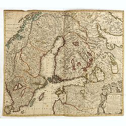
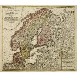
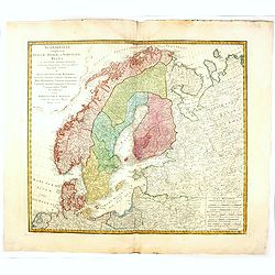
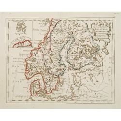
Carte des Courones du Nord Dediee Autres Puissant et tres Invincible Prince Charles XII Roy de Suede, des Gots et des Vandales
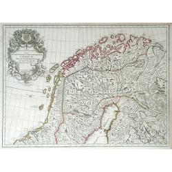
This is the top half of a two-part map of the larger Scandinavia/Russia region. This detailed map depicts Norway, Sweden, and Finland's northern areas and the Gulf of Bot...
Place & Date: Paris, 1706
Selling price: ????
Please login to see price!
Sold in 2010
![Carte des Courones du Nord. [2 sheets]](/uploads/cache/41938-250x250.jpg)
Carte des Courones du Nord. [2 sheets]
Two-sheet map of Denmark, Sweden, Finland and the Baltic states with the address : "Carte des Courones du Nord. Chez l’Auteur, Rue des Canétes prés St. Sulpice. ...
Place & Date: Paris, 1706
Selling price: ????
Please login to see price!
Sold in 2025
![Antique map of Scandinavia] Carte des Courones du Nord.](/uploads/cache/82019-250x250.jpg)
Antique map of Scandinavia] Carte des Courones du Nord.
[Antique map of Scandinavia] 'Carte des Courones du Nord', by Guillaume de l' Isle (1675-1724), a Royal Geographer. He was the most influential cartographer of the first ...
Place & Date: Paris, 1706
Selling price: ????
Please login to see price!
Sold in 2020
La Scandinavie et les Environs où sont les Royaumes.
Fine map of Scandinavia and the Baltic States with figurative armorial cartouche and small scale of miles. Engraved by Cordier.
Place & Date: Paris, 1708
Selling price: ????
Please login to see price!
Sold in 2009

La Scandinavie et les Environs où sont les Royaumes.
Fine map of Scandinavia and the Baltic States with figurative armorial cartouche and small scale of miles. Prepared by Sanson and published by Hubert Jaillot.Engraved by ...
Place & Date: Paris, dated 1708
Selling price: ????
Please login to see price!
Sold in 2010
La Scandinavie et les Environs où sont les Royaumes.
Fine map of Scandinavia and the Baltic States with figurative armorial cartouche and small scale of miles. Prepared by Sanson and published by Hubert Jaillot.Engraved by ...
Place & Date: Paris, dated 1708
Selling price: ????
Please login to see price!
Sold in 2012
Carte des Courones du Nord.
Denmark, Sweden, Finland and the Baltic states are included.
Place & Date: Amsterdam, 1708
Selling price: ????
Please login to see price!
Sold in 2016
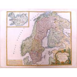
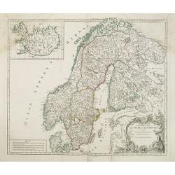
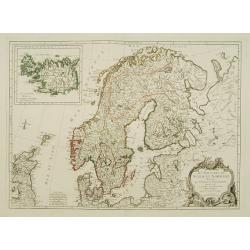
Sweden Corrected from the Observations Communicated to the Royal Society in London and the Royal Academy in Paris. . .
A large-scale general map of Scandinavia. In addition to Sweden, it shows Norway, Denmark and Finland. The new city of St. Petersburg (founded 1703) is shown at the head ...
Place & Date: London, 1710
Selling price: ????
Please login to see price!
Sold in 2020
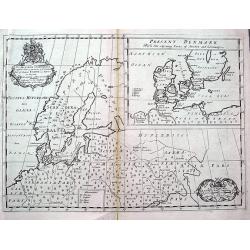
A New Map of Denmark, Norway, Sweden & Moscovy.
A striking decorative map of Skandinavia with Russian Europe added. The cities in Germany and Poland are shown as being part of Sweden and Denmark. Nova Zembla is shown a...
Place & Date: London, 1714
Selling price: ????
Please login to see price!
Sold in 2015
Nouvelle Carte de Scandinavie ou des Etats du Nord dressee sur les Observations. . .
Henri Chatelain's large format decorative map of Scandinavia featuring no less than 34 provincial heraldic shields, 17 on each flank of the map, together with tables of t...
Place & Date: Amsterdam, ca 1714
Selling price: ????
Please login to see price!
Sold in 2018
A New Map of Ancient Scandinavia. . .
A scarce map extending from northern Germany until Russia with old place names. Including Scandinavia and the Baltic. An inset map shows Denmark and southern Sweden in mo...
Place & Date: Oxford, ca 1701-1714
Selling price: ????
Please login to see price!
Sold in 2018
Finmarchae et Laplandiae Maritima. / Nieuwe Pascaert vande Kusten Finmarcken en Lapland Streckende van Dronten tot Archangel.
An eye-catching chart of Barents Sea and White Sea (with Archangelsk) with the coast of Norway, Lapland and peninsula Kola.. Coastal cities, bodies of water and islands a...
Place & Date: Amsterdam, 1715
Selling price: ????
Please login to see price!
Sold in 2012
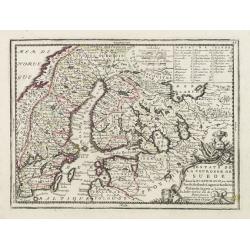
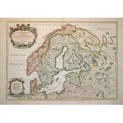
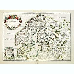
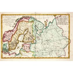
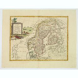
Estats de la Couronne de Suede dans la Scandinavie, ou sont Suede, Gotlande, Lapponie Suedoise, Finlande, Ingrie et Livonie. Subdivisees en leurs Provinces..
Lovely small map centered on Finland, with Sweden and much of Norway to the west, Frontieres de Moscovie to the east.Depiction of lakes, rivers and coastline reminiscent ...
Place & Date: Paris, 1719
Selling price: ????
Please login to see price!
Sold in 2009
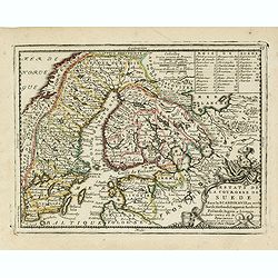
Estats de la Couronne de Suede dans la Scandinavie, ou sont Suede, Gotlande, Lapponie Suedoise, Finlande, Ingrie et Livonie. Subdivisees en leurs Provinces..
Lovely small map centered on Finland, with Sweden and much of Norway to the west, Frontieres de Moscovie to the east.Depiction of lakes, rivers and coastline reminiscent ...
Place & Date: Paris, 1719
Selling price: ????
Please login to see price!
Sold in 2019
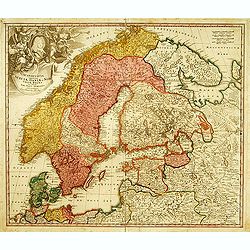
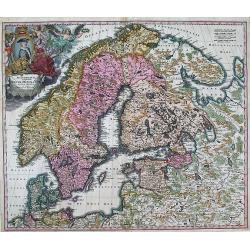
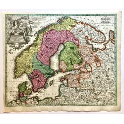
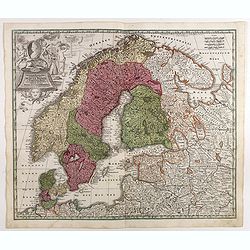
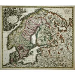
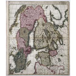
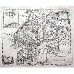
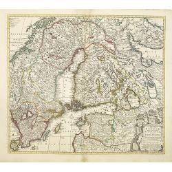
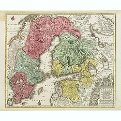
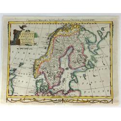
Scandinavia complectens Sueciae, Daniae & Norvegia.
Johann Baptist Homann's well-engraved map has a large decorative cartouche. Detailed map of Scandinavia. Johann Baptist Homann (1663-1724) was a German engraver and publi...
Place & Date: Nuremberg, 1720
Selling price: ????
Please login to see price!
Sold
Carte Genealogique pour conduire a l' histore des Rois du Nord, la Carte de leurs etats, leurs Armes &tc. / nouvelle cart du Royaume de Suede. / Carte du Royaume de Gothie.
Henri Abraham Chatelain was a Amsterdam-based geographer and publisher. His main product is the 'Atlas Historique et Méthodique', in seven volumes, published between 171...
Place & Date: Amsterdam, 1710-1720
Selling price: ????
Please login to see price!
Sold
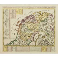
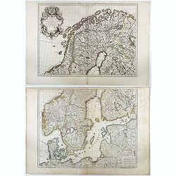
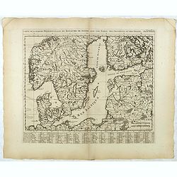
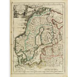
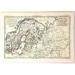
Carte de la Partie Septentrionale du Royaume de Suede?
Map of the northern part of Scandinavia. It covers the area straddling Norway, Sweden, Finland and Russia.Zacharie Chatelain (d.1723) was the father of Henri Abraham (168...
Place & Date: Amsterdam, ca. 1720
Selling price: ????
Please login to see price!
Sold
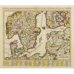
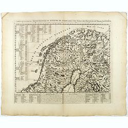
Carte de la Partie Meridionale du Royaume de Suede?
Map of the southern part of Scandinavia with letter key at the bottom.Zacharie Chatelain (d.1723) was the father of Henri Abraham (1684-1743) and Zacharie Junior (1690-17...
Place & Date: Amsterdam, ca. 1720
Selling price: ????
Please login to see price!
Sold
SCANDINAVIA complectens SUECIAE, DANIAE, & NORVEGIAE, REGNA. ex Tabula Joh. Baptista Homann.
A large, detailed map showing all of Scandinavia, including the Baltic region and parts of Russia. An attractive title cartouche decorates the upper left corner of the ma...
Place & Date: Nurnberg, c.1720
Selling price: ????
Please login to see price!
Sold in 2013
Regni Sueciae in Omnes Suas Subjacentes.
Large, detailed, hand-colored map featuring Sweden, Finland, Eastern Russia and Northern Poland, Lithuania, Latvia & Estonia. Fine allegorical title cartouche with fo...
Place & Date: Nuremberg, 1720
Selling price: ????
Please login to see price!
Sold in 2017
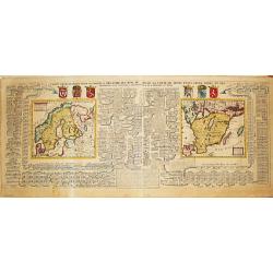
Carte généalogique pour conduire à l'histoire des rois du nord de la carte de leurs états, leurs armes et des remarques pour conduire à l'intelligence de l'histoire du nord.
Interesting sheet with a genealogical table of the Kingdoms of the Scandinavian countries with two small maps: Scandinavia and Southern Sweden, with descriptive French te...
Place & Date: Amsterdam, 1720
Selling price: ????
Please login to see price!
Sold in 2018
Regni Sueciae in omnes suas Subjacentes Provincias accurate divisi Tabula Generalis. . .
Johann Baptist Homann's well-engraved map of Scandinavia, the Baltic Sea, Lithuania, Latvia, Estonia, Curlandia, etc. with a large decorative title cartouche.Johann Bapti...
Place & Date: Nuremberg, ca. 1720
Selling price: ????
Please login to see price!
Sold in 2016
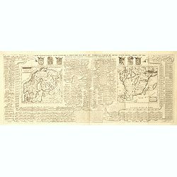
![[2 maps] Carte des Couronnes du Nord Dédiée au .... CHARLES XII, ROY](/uploads/cache/38418-250x250.jpg)
[2 maps] Carte des Couronnes du Nord Dédiée au .... CHARLES XII, ROY
A large two sheet map of the Baltic, Sweden and Norway by G. de Lisle. Delisle was an important French cartographer of the early 18th century. He held the position of Fir...
Place & Date: Paris , ca. 1720
Selling price: ????
Please login to see price!
Sold in 2018
Sueciae Regnum cum vicinis Regionibus.
Uncommon map of Scandinavia. The originally colored title cartouche is surrounded by mythological figures. From Atlas Portatif.
Place & Date: Nuremberg 1724
Selling price: ????
Please login to see price!
Sold
Carte Généalogique Pour Conduire à l'Histoire des Rois du Nord de la Carte de Leurs Etats, Leurs Armes et des Remarques Pour Conduire à l'Intelligence de l'Histoire du Nord
A very detailed, and wonderfully colored, composite sheet, with a genealogical table of the Kingdoms of the Scandinavian countries, with two small maps: Scandinavia and S...
Place & Date: Amsterdam, 1728
Selling price: ????
Please login to see price!
Sold in 2016
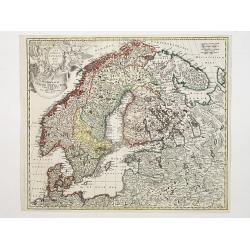
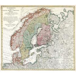
Synopsis Plagae Septentrionalis size Sueciae Daniae et Norwegiae Regn.
A superb 18th century original hand colored map of Scandinavia that extends to the east to include portions of Russia, the Baltic states, and the northern part of Germany...
Place & Date: Vienna, 1728
Selling price: ????
Please login to see price!
Sold in 2019
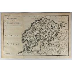
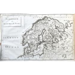
Scandinavie ou Royaume du Nort.
Striking map of Scandinavia. It is from “METHODE POUR ETUDIER L’HISTOIRE” by L’Abbe Lenglet du Fresnoy, published in Paris in 1729. The map is quite rare and is n...
Place & Date: Paris, 1729
Selling price: ????
Please login to see price!
Sold in 2018
Synopsis Plagae, Septentrionalis sive Sueciae Daniae, et Norwegiae Regn . . .
Decorative map of Scandinavia, the Baltic and contiguous parts of Russia, with an ornate cartouche which features a portrait of Ulrica Eleonora, the Queen of Sweden, rest...
Place & Date: Augsbourg, 1730
Selling price: ????
Please login to see price!
Sold in 2017
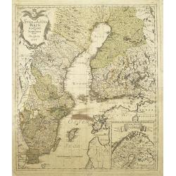
Carte des Couronnes du Nord qui Comprend les Royaumes de Danemark, Suede & Norwege.
A large format, highly detailed two sheet map of Scandinavia and the Baltic States. A beautifully engraved map with a highly decorative cartouche and two compass roses. S...
Place & Date: Amsterdam, 1730
Selling price: ????
Please login to see price!
Sold in 2020

Carte des Estats de la Couronne de Suède avec des Remarques et des Tables Tres Instructives.
Map shows Denmark with the southern part of Sweden and the northern coast of Germany with the island Rügen.This impressive map is the sixth plate in volume four of Chate...
Place & Date: Amsterdam, 1732
Selling price: ????
Please login to see price!
Sold in 2023
Carte de la Partie Meridionale du Royaume de Suede...
Map of the southern part of Scandinavia with letter key at the bottom.Zacharie Chatelain (d.1723) was the father of Henri Abraham (1684-1743) and Zacharie Junior (1690-17...
Place & Date: Amsterdam, ca. 1732
Selling price: ????
Please login to see price!
Sold in 2017
Carte de la Partie Septentrionale du Royaume de Suede...
Map of the northern part of Scandinavia. It covers the area straddling Norway, Sweden, Finland and Russia.Zacharie Chatelain (d.1723) was the father of Henri Abraham (168...
Place & Date: Amsterdam, ca. 1732
Selling price: ????
Please login to see price!
Sold in 2017
Scandinavie ou Royaumes du Nort.
Scarce map of Scandinavia and the Baltics. It shows the area from Denmark until Moscow, including parts of Poland. Names regions, some cities, lakes, rivers, and so on.Pu...
Place & Date: Paris, 1734
Selling price: ????
Please login to see price!
Sold in 2021
Nuova Carta del Regno di Svezia...
An attractive map of Scandinavia.Albrizzi was the first publisher to issue Tirion's maps: Tirion's own atlas was issued in Amsterdam in 1744.
Place & Date: Venice, Albrizzi, 1740
Selling price: ????
Please login to see price!
Sold
Nova mappa geographica Sueciae ac Gothiae regna ut et Finlandiae Ducatum ac Lapponia. . .
Standard map showing Sweden, Norway, Finland and surrounding countries. The copper plate was later on used by T.Lotter.
Place & Date: Nuremberg, ca. 1740
Selling price: ????
Please login to see price!
Sold in 2016
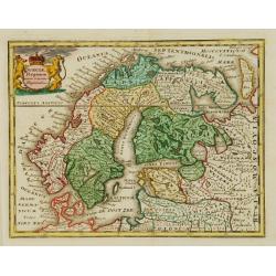
Seconde Carte des COURONES DU NORD qui Comprend le ROYAUME DE DENEMARK &c.
A superb, large scale sheet map of Scandinavia,Finland Estonia,and part of Russia by one of France's greatest cartographers, This is one of a two part map from a Dutch ed...
Place & Date: Amsterdam, 1742
Selling price: ????
Please login to see price!
Sold in 2020
Synopsis Plagae Septentrionalis Sueciae Daniae et Norwegiae Regn.
Large decorative map of Scandinavia filled with topographical and political information. Attractive title cartouche with figures and a coat of arms.
Place & Date: Augsburg, 1744
Selling price: ????
Please login to see price!
Sold
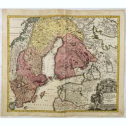
![Cartes Des Courones Du Nord Qui Comprend les Royaumes de Danemark, Suede & Nowege, &c.. [and] Seconde Carte des Courones du Nord..](/uploads/cache/21528-250x250.jpg)
Cartes Des Courones Du Nord Qui Comprend les Royaumes de Danemark, Suede & Nowege, &c.. [and] Seconde Carte des Courones du Nord..
Large, highly detailed two sheet map of Scandinavia. Beautifully engraved with a decorative title cartouche and 2 compass roses.Shows illustrated topography with roads, r...
Place & Date: Amsterdam, c. 1745
Selling price: ????
Please login to see price!
Sold in 2009
Niewe Kaart van het Koninkrijk Zweden.
Izaak Tirion (d. 1769) Amsterdam publisher. His ' Nieuwe en beknopte handatlas' saw 6 editions between before 1740 and after 1784. Also ' Tegenwoordige staat van alle vol...
Place & Date: Amsterdam, c. 1745
Selling price: ????
Please login to see price!
Sold in 2018
![Cartes Des Courones Du Nord Qui Comprend les Royaumes de Danemark, Suede & Nowege, &c.. [together with] Seconde Carte des Courones du Nord..](/uploads/cache/29997-250x250.jpg)
Cartes Des Courones Du Nord Qui Comprend les Royaumes de Danemark, Suede & Nowege, &c.. [together with] Seconde Carte des Courones du Nord..
Large, highly detailed two sheet map of Scandinavia. Beautifully engraved with a decorative title cartouche and 2 compass roses.Shows illustrated topography with roads, r...
Place & Date: Amsterdam c. 1745
Selling price: ????
Please login to see price!
Sold in 2010
Sueciae Magnae, totius Orbis Regni antiquissimi, hodierna in sex Principales suas partes, Gothiam nempe, Sueciam propriam sive strictae Sumptam, Nordlandiam, Ingriam, Livoniam', and impressum...
Map of Greater Sweden: Sweden, Finland, Estonia, Latvia. From: Atlas sive Geographia compendiosa ... / Atlas Nouveau contenant tous les partis du Monde (Composite Atlas),...
Place & Date: Amsterdam, ca. 1745
Selling price: ????
Please login to see price!
Sold in 2022
Scandinavia complectens Sueciae, Daniae & Norvegia..
Johann Baptist Homann's well-engraved map has a large decorative cartouche. Detailed map of Scandinavia.Johann Baptist Homann (1663-1724) was a German engraver and publis...
Place & Date: Nuremberg 1747
Selling price: ????
Please login to see price!
Sold
Svea och Göta Riken med Finland och Norland : afritade i Stockholm år 1747
A detailed and rare map of Sweden and Finland, published in Stockholm, 1747. In lower right a cartouche with the north of Norway.Engraved by George Biurman (1700-1755), w...
Place & Date: Stockholm, 1747
Selling price: ????
Please login to see price!
Sold in 2010
Scandinavia complectens Sueciae, Daniae & Norvegia. . .
Johann Baptist Homann's well-engraved map has a large decorative cartouche. Detailed map of Scandinavia.Johann Baptist Homann (1663-1724) was a German engraver and publis...
Place & Date: Nuremberg, 1747
Selling price: ????
Please login to see price!
Sold in 2011
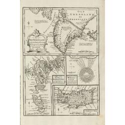
A Map of Old Greenland or Oster Bygd & Wester Bygd ... An Improved Map of Iceland ... A Map of the Islands of Ferro ... A Draught of the Whirlpool on the South East of Sumbo Rocks
An unusual copper engraving by E. Bowen from 'A Complete System of Geography'. Featuring 4 small maps of the North Atlantic Islands Greenland, Iceland and Faroe. A curios...
Place & Date: London, 1747
Selling price: ????
Please login to see price!
Sold in 2011
Scandinavia complectens Sueciae, Daniae & Norvegia. . .
Johann Baptist Homann's well-engraved map has a large decorative cartouche. Detailed map of Scandinavia.Johann Baptist Homann (1663-1724) was a German engraver and publis...
Place & Date: Nuremberg, 1747
Selling price: ????
Please login to see price!
Sold in 2018
(Map of Scandinavia).
Engraved by "Liébaux, le fils".
Place & Date: Paris, 1750
Selling price: ????
Please login to see price!
Sold in 2008
Tabula Geographica Europae..
Interesting map centered on the Faroe Islands. It extends from the eastern coast of Greenland as far as Sweden, showing Iceland and the British Isles.Engraved by N.F. Sau...
Place & Date: Berlin c.1750
Selling price: ????
Please login to see price!
Sold
Scandinavia complectens Sueciae, Danaie & Norvegiae Regna.
Map of Scandinavia centerd on Sweden, Norway and Denmark.
Place & Date: Nuremberg, 1750
Selling price: ????
Please login to see price!
Sold in 2009
Mer Baltique - Golfe de Bothnie.
The map is centered on the Baltic Sea, including Denmark, Finland, a part of Poland, and southern parts of Norway and Sweden. Engraved by Liébaux le fils.
Place & Date: Paris, 1750
Selling price: ????
Please login to see price!
Sold in 2009
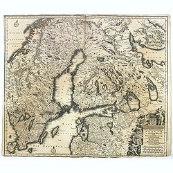
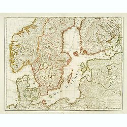
Regni Sueciae Tabula Generalis, divisa in Sueciae, Gotiae.
Fine map centered on Finland, including part of Sweden, Norway and Russia.The map was originally issued by Frederick de Wit but than re-issued by Pieter Mortier in Amster...
Place & Date: Amsterdam, 1751
Selling price: ????
Please login to see price!
Sold in 2018
Karte von den Nord-Meeren zur allgemeinen Historie der Reisen...
Map of the North sea with coastlines of Greenland, Iceland and Norway. In: Allgemeine Historie der Reisen zur Wasser und zu Lande: oder Sammlung aller Reisebeschreibungen...
Place & Date: Leipzig, 1753
Selling price: ????
Please login to see price!
Sold in 2011
Carte reduite de la Mer du Nord. . . / Zusammengezogene Karte des Nordmeeres. . .
Map of the North Atlantic Ocean. In: Allgemeine Historie der Reisen zur Wasser und zu Lande: oder Sammlung aller Reisebeschreibungen.. in Englischen zusammen getragen, un...
Place & Date: Leipzig, 1753
Selling price: ????
Please login to see price!
Sold in 2008
Sweden, Denmark, Norway and Finland.
A small but detailed copper engraved map of Scandinavia, including the Baltic. A small inset map shows Spitsbergen (here named East Greenland) and the North Cape. Names m...
Place & Date: London, ca 1754
Selling price: ????
Please login to see price!
Sold in 2020
La Scandinavie ounla Suede et Danmark.
Fine map of Scandinavia with a decorative title cartouche. George Louis Le Rouge was active from 1740- till 1780 as a publisher, and was appointed engineer for the King o...
Place & Date: Paris 1756
Selling price: ????
Please login to see price!
Sold
Les Royaumes de Suede et de Norwege.
Detailed, large map of Scandinavia published in Vaugondy's "Atlas Universel," one of the best-selling French atlases of the 1700s. It has a large, fancy title c...
Place & Date: Paris, 1756
Selling price: ????
Please login to see price!
Sold in 2013
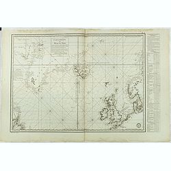
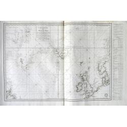
Carte Réduite des Mers du Nord Pour servir a l'Histoire Generale des Voyages.
Detailed sea chart of the coasts of Scandinavia, the British Isles, Iceland (with volcano Hekla), Greenland and contiguous parts of Canada.Prepared by Nicholas Bellin for...
Place & Date: 1758
Selling price: ????
Please login to see price!
Sold in 2014
Carte Réduite des Mers du Nord. 1758.
Jaques Nicolas Bellin (1702-720) was the most important French hydrographer of the 18th century. Sea-atlas 'Hydrographique Français' , 1756-65, atlas to accompany Prévo...
Place & Date: Paris, 1760
Selling price: ????
Please login to see price!
Sold
Regni Sueciae.
Attractive and detailed map of Scandinavia, including part of Russia, here in a second state with the address of Jean Covens and Cornelis Mortier.The Amsterdam publishing...
Place & Date: Amsterdam, 1760
Selling price: ????
Please login to see price!
Sold in 2011
La Suede et La Norwege Avec l' Islande divisee par Provinces et sous deux Metropoles Ecclesiastiques.
Louis Brion de la Tour (1756-1823), ' Atlas Géneral, Civil et Ecclésiastique', 1766, ' Atlas Général', 1790-98. Louis Charles Desnos (fl.1750-70), Le Rouge's 'Atlas N...
Place & Date: Paris, 1766
Selling price: ????
Please login to see price!
Sold
Les royaumes de Suede et de Norvège. . .
Detailed map of Sweden and Norway with inset of Iceland. From his "Atlas Universel".Address has been ereased. Gilles Robert de Vaugondy (1688–1766), also know...
Place & Date: Paris, 1757-1768
Selling price: ????
Please login to see price!
Sold in 2013
Nova mappa geographica Sueciae ac Gothiae regna ut et Finlandiae Ducatum ac Lapponiam?
Fine map including most of Sweden, Lapland and Finland.T.C. Lotter married M. Seutter's daughter in 1740 and succeeded him in 1756. Lotter used the copperplate of Seutter...
Place & Date: Augsbourg, 1770
Selling price: ????
Please login to see price!
Sold in 2010
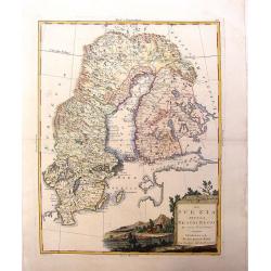
Scandinavia complectens Sveciae, Daniae et Norvegiae Regna ...
Scandinavia by Homann Heirs
Place & Date: Nuremberg, 1776
Selling price: ????
Please login to see price!
Sold in 2009
Scandinavia complectens sueciae, Daniae et Norvegiae. . .
Detailed map of Scandinavia, covering Sweden, Denmark, and Norway. Published by the Homann Heirs.
Place & Date: Nuremberg, 1776
Selling price: ????
Please login to see price!
Sold in 2011
Carte réduite des Mers du Nord Comprise entre le 48° et le 72° Degré de Latitude Septle et entre le lle Degré de Longitude Orientale et le 61e. . .
Uncommon sea of the North Atlantic, published by the French Dépot de la Marine. Including the coasts of Scandinavia, the Baltic Sea, British Isles, Iceland, Greenland a...
Place & Date: Paris, 1776
Selling price: ????
Please login to see price!
Sold in 2018
Scandinavia complectens sueciae, Daniae et Norvegiae. . .
A detailed map of Scandinavia covering Sweden, Denmark, and Norway. Published by the Homann Heirs.
Place & Date: Nuremberg, 1776
Selling price: ????
Please login to see price!
Sold in 2019
Carte Réduite des Mers du Nord . . .
A highly interesting large-scale sea chart of the North Atlantic. Extends from Labrador until Sweden. Shows the coasts of Scandinavia, the Baltic Sea, British Isles, Icel...
Place & Date: Paris, 1776
Selling price: ????
Please login to see price!
Sold in 2018
Carte Reduite des Mers du Nord. . .
A scarce example of this attractive chart of the north Atlantic, including, Scandinavia, Iceland, Greenland, parts of Canada &c., from Prevost's 'Histoire Generale de...
Place & Date: Amsterdam, 1776
Selling price: ????
Please login to see price!
Sold in 2019
Les Royaumes de Suede et Norwege divisés par Provinces..
Detailed map of Scandinavia, with inset of Iceland. The author is M. Janvier.
Place & Date: Venise, ca. 1780
Selling price: ????
Please login to see price!
Sold
Le Nord de l'Europe.
Rigobert Bonne (1727-1795), French cartographer. His maps are found in a.o. Atlas Moderne (1762), Raynal's Histoire Philos. du Commerce des Indes (1774) and Atlas Encyclo...
Place & Date: Paris, c. 1780
Selling price: ????
Please login to see price!
Sold in 2009
Le Nord de L'Europe...
A fine map of Northern Europe and European Russia. It includes present day Norway, Sweden, Denmark, Finland and parts of Russia, by Rigobert Bonne for G. Raynal’s “AT...
Place & Date: Paris, 1780
Selling price: ????
Please login to see price!
Sold in 2018
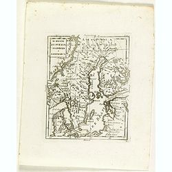
Li regni di svezia Norvegia e Danimarca.
Rare map of Scandinavia, from "Atlante Novissimo ad uso Dei Giovani Studiosi Contenuto In Carte XXVII.", published by Giovanni Zempel in Rome, ca. 1780.The map ...
Place & Date: Rome, 1780
Selling price: ????
Please login to see price!
Sold in 2018
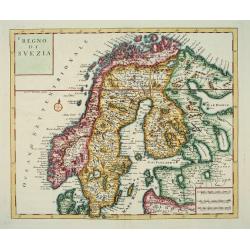
La Svezia Divisa Ne\' Suoi Regni di Nuuva Projezione
A lovely decorative map of Sweden, Finland and Laponia (Lapland). It has a pleasing, scenic title cartouche. Zatta (1775-1797) was the most prominent Italian map publish...
Place & Date: Vienna, 1781
Selling price: ????
Please login to see price!
Sold in 2013
Li Regni di Svezia, Danimarca e Norvegia. . .
Antonio Zatta's detailed map of Sweden, Denmark, Norway and Finland, embellished with a delicately colored title cartouche depicting fishermen hauling in their nets. Show...
Place & Date: Venice, 1781
Selling price: ????
Please login to see price!
Sold in 2019
A New And Correct Map Of Norway, Sweden And Denmark. From The Latest Geographical Improvements
An attractive and interesting map, published for George Millar's "New and Universal System of Geography" - a Georgian compendium of reports and accounts from al...
Place & Date: London, 1782
Selling price: ????
Please login to see price!
Sold in 2017
Les Royaumes De Suede Norwege et Danemark ..
Rare map of Scandinavia prepared by J.B.Nolin and published by Monhare for his Atlas Général a l'usage des colleges et maisons d'education.. With inset map of Lapland a...
Place & Date: Paris, 1783
Selling price: ????
Please login to see price!
Sold in 2009