Browse Listings in Europe > Scandinavia > general
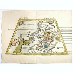
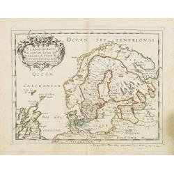
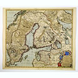
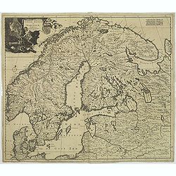
Tabula Moderna Norbegie et Gottie.
Rare woodblock map of Scandinavia published by Waldseemüller, from the first modern atlas, because the 20 new maps in this atlas show all parts of the world based on con...
Place & Date: Strasbourg, Johann Schott, 1513-1520
Selling price: ????
Please login to see price!
Sold in 2020
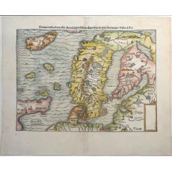
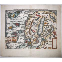
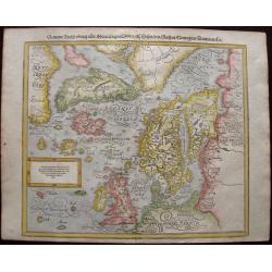
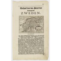
Gemeine Beschreibung Aller Mitnachtigen Lander Schweden, Gothen, Nordwegien, Dennmarck &c.
One of the earliest woodcut maps of Scandinavia. Shows Iceland, Norway, Sweden, Finland, Scotland, Denmark with the North Sea and Baltic Sea. Sebastian Munster's second m...
Place & Date: Basel, ca 1540
Selling price: ????
Please login to see price!
Sold in 2019
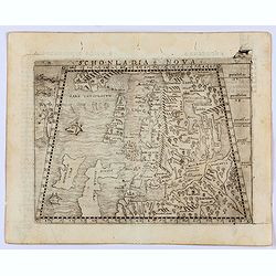
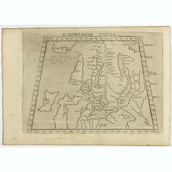
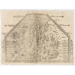
Sconladia Nova.
Gastaldi's modern map of Scandinavia, Iceland, and the Baltic According to Bill Ginsberg the map was "built upon previous publications, in particular, the representa...
Place & Date: Venice, 1548
Selling price: ????
Please login to see price!
Sold in 2022
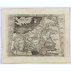
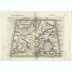
Tabula Europae VIII. (Russia, Ukraine, Baltic, Scandinavia)
Gastaldi's map showing the Baltic in the North and the Black Sea in the south. Based upon Ptolemy.Embellished is a sailing ship, sea monster and several curious animals.I...
Place & Date: Venice, 1548
Selling price: ????
Please login to see price!
Sold in 2022
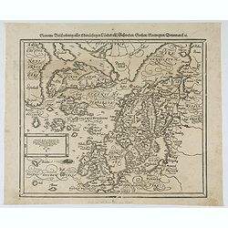
Gemeine beschreibung aller Mitnaechtigen Laender, Schweden, Gothen, Nordwegien, Dennmarck, sc.
An early Sebastian Münster's woodcut map of Scandinavia, based on the 'Carta Marina' of Olaus Magnus, 1539. The map includes Norway, Sweden, Finland, Denmark, Iceland, S...
Place & Date: Basel, ca 1550
Selling price: ????
Please login to see price!
Sold in 2020
![[Lot of 19 leaves of Scandinavia, Greenland, Island]](/uploads/cache/48298-250x250.jpg)
[Lot of 19 leaves of Scandinavia, Greenland, Island]
Nineteen text leaves illustrated with wood block prints and maps relating to Scandinavia, Greenland and Island. From the 1552 Latin text edition of Münster's Cosmographi...
Place & Date: Basel, 1552
Selling price: ????
Please login to see price!
Sold in 2022
Gemeine beschreibung aller Mitnaechtigen Laender, Schweden, Gothen, Nordwegien, Dennmarck, sc.
An early Sebastian Münster's woodcut map of Scandinavia, based on the 'Carta Marina' of Olaus Magnus, 1539. The map includes Norway, Sweden, Finland, Denmark, Iceland, S...
Place & Date: Basel, 1560
Selling price: ????
Please login to see price!
Sold in 2021
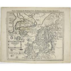
Schonladia Nuova.
Depicting Scandinavia in a trapezoidal projection, being one of the earliest obtainable modern maps of Scandinavia. The map combines Ptolemaic and modern cartographic inf...
Place & Date: Venice, 1561
Selling price: ????
Please login to see price!
Sold in 2017
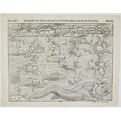
Mörewunder vnd seltzame thier
Spectacular woodcut of mythical land with sea monsters and animals. The monsters were first engraved in the ‘Carta Marina’ of 1539 by Olaus Magnus and have been us...
Place & Date: Basel, 1561
Selling price: ????
Please login to see price!
Sold in 2022
![[Southern Scandinavia to central Germany, Netherlands and East England]](/uploads/cache/25014-250x250.jpg)
[Southern Scandinavia to central Germany, Netherlands and East England]
The rare second state is dated 1562, but still lacks the imprint of Camocio. The map has no title and extends from Southern Scandinavia to Central Germany, The Netherland...
Place & Date: Venice, 1562
Selling price: ????
Please login to see price!
Sold
(SCANDINAVIE). Monogr. THW (Thomas Weber) dated 1567.
Rare and important map of Scandinavia from Olaus Magnus' Historia Olai Magni gothi archiepiscop upsalensis, de gentium septentrionalium, published in Basel in 1567.The ma...
Place & Date: Basle, 1567
Selling price: ????
Please login to see price!
Sold in 2019
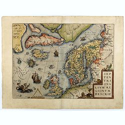
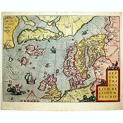
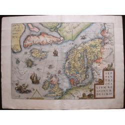
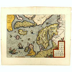
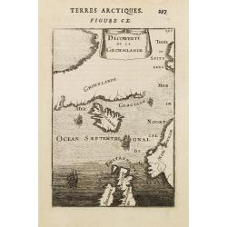
Septentrionalium Regionum Descrip.
Early second state of this influential map of the Arctic, including Scandinavia, Iceland, Greenland and part of the North American continent, includes also the legendary ...
Place & Date: Antwerp, 1571/1573
Selling price: ????
Please login to see price!
Sold in 2018
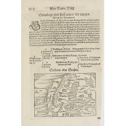
Gotland oder Gothen.
Map of Scandinavia. From his Cosmographia, that great compendium of Renaissance knowledge. An exciting print.Sebastian Münster was born in Nierder-Ingelheim, near Mainz ...
Place & Date: Basle 1550-1580
Selling price: ????
Please login to see price!
Sold in 2010
![[Map of Scandinavia]](/uploads/cache/91426-250x250.jpg)
[Map of Scandinavia]
Small Scandanvia woodcut map by Sebastian Münster.
Place & Date: Basel, c. 1580
Selling price: ????
Please login to see price!
Sold in 2010
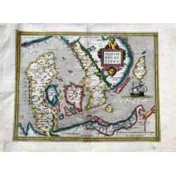
Daniae regni typus.
A very decorative, and nicely colored example of Ortelius' map of Denmark, extending from Schleswig Holstein and Mechlenberg, Pomerania and Prussian coasts to the Norwegi...
Place & Date: Antwerp, ca 1580
Selling price: ????
Please login to see price!
Sold in 2020
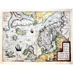
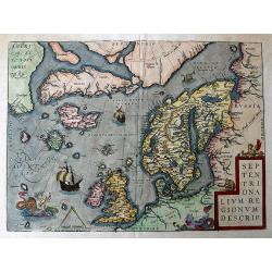
Septentrionalium Regionum Descrip.
This influential map of the Arctic, including Scandinavia, Iceland, Greenland and part of the North American continent, includes also the legendary islands of i.a. Drogeo...
Place & Date: Antwerp, 1584
Selling price: ????
Please login to see price!
Sold in 2014
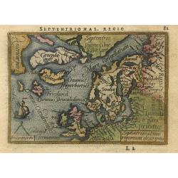
Septentrionalium regionum descriptio
Handsome miniature map based on Ortelius' important map of the Arctic regions with the mythical islands of Drogeo and Frieslant. The map is beautifully engraved with stip...
Place & Date: Antwerp, 1588
Selling price: ????
Please login to see price!
Sold
Gemeine Beschreibung aller Mitnachtigen Lander/ alsz Schweden / Gothen / Norwegien / Dennmark &c
Interesting wood block printed map of Europe, Scandinavia, England, Denmark, Norway, Sweden, Iceland, The Baltics, Greenland, and America.The map shows two Greenlands, on...
Place & Date: Basle, 1588
Selling price: ????
Please login to see price!
Sold in 2014
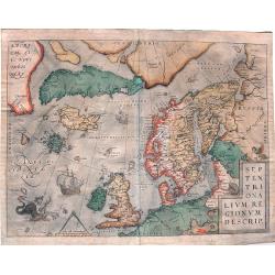
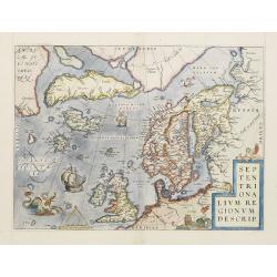
Septentrionalium Regionum Descrip.
Influential map of the Arctic. It includes Scandinavia, Iceland, Greenland and part of the North American continent, together with the legendary islands of the north: Dro...
Place & Date: Antwerp, ca. 1590
Selling price: ????
Please login to see price!
Sold in 2015
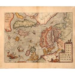
Septentrionalium Regionum Descrip.
A fascinating and important map of the North Atlantic by A. Ortelius in beautiful original colors.
Place & Date: Antwerp, 1590
Selling price: ????
Please login to see price!
Sold in 2016
Septentrionalium Regionum Descrip.
An influential map of the Arctic. It includes Scandinavia, Iceland, Greenland and part of the North American continent, together with the legendary islands of the north: ...
Place & Date: Antwerp, 1590
Selling price: ????
Please login to see price!
Sold in 2018
Septentrionalium Regionum Descrip.
This influential map of the Arctic, including Scandinavia, Iceland, Greenland and part of the North American continent, includes also the legendary islands of i.a. Drogeo...
Place & Date: Antwerp 1598
Selling price: ????
Please login to see price!
Sold
SEPTENTRIONALIUM REGIONUM DESCRIP, 1598
A copperplate full colored decorative map of North Europe.This influential map of the Arctic, including Scandinavia, Iceland, Greenland and part of the North American con...
Place & Date: Antwerp, 1598
Selling price: ????
Please login to see price!
Sold in 2019
Europae Tabula VIII.
The third state of Ruscelli's map of Eastern Europe and Scandinavia, based upon Claudius Ptolemy. Showing "Daniae et Norvegiae" as an island, with a separate is...
Place & Date: Venice, 1598
Selling price: ????
Please login to see price!
Sold in 2018
Septentrionalium Regionum Descrip.
This influential map of the Arctic, including Scandinavia, Iceland, Greenland and part of the North American continent, includes also the legendary islands of i.a. Drogeo...
Place & Date: Antwerp, 1598
Selling price: ????
Please login to see price!
Sold in 2018
Gemeine Beschreibung aller Mitnachtigen Lander / alss Schweden / Gothen / Norwegien / Denmarck / &c.
Sebastian Münster’s third and final map of Scandinavia including England, Denmark, Norway, Sweden, Iceland, The Baltics, Greenland and America by Sebastian Munster 159...
Place & Date: Basle, 1598
Selling price: ????
Please login to see price!
Sold in 2019
Septentrionalium Regionum Descrip.
A fantastic map of the northern Atlantic. Shows a part of America, Greenland, Iceland, the British Islands, Scandinavia, and parts of Europe and Russia. With several phan...
Place & Date: Antwerp, 1601
Selling price: ????
Please login to see price!
Sold in 2016
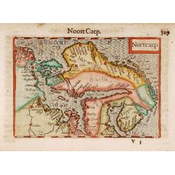
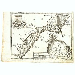
Nortcaep
A beautifully engraved early 17th century map of Scandinavia, west to the top. With lovely hand color.
Place & Date: Amsterdam 1606
Selling price: ????
Please login to see price!
Sold
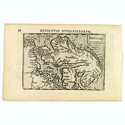
Nortcaep.
A lovely miniature map of Scandinavia, published by Petrus Bertius, in Amsterdam at the beginning of the seventeenth century.North is orientated to the right. The sea is ...
Place & Date: Amsterdam, 1606
Selling price: ????
Please login to see price!
Sold in 2019
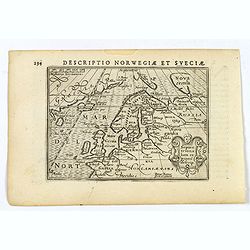
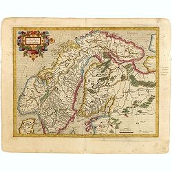
Descriptio Norwegiae et Sveciae.
An attractive miniature map of Sweden and Norway, and northern Europe by Petrus Bertius, published in Amsterdam at the beginning of the seventeenth century. Apart from Sc...
Place & Date: Amsterdam, 1606
Selling price: ????
Please login to see price!
Sold in 2019
Svecia, et Norwegia etc.
Map of Scandinavia, decorated with a small strap work title cartouche. From the first French-text edition of Jodocus Hondius' Atlas Minor.Shortly after the publication of...
Place & Date: Amsterdam, 1608
Selling price: ????
Please login to see price!
Sold in 2009
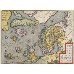
Septentrionalium Regionum Descrip.
From the very rare Italian text edition. This influential map of the Arctic, including Scandinavia, Iceland, Greenland and part of the North American continent, includes ...
Place & Date: Antwerp, 1608
Selling price: ????
Please login to see price!
Sold in 2009
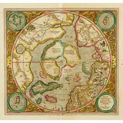
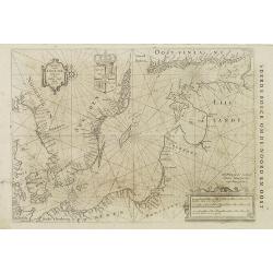
SEPTENTRIONALIUM Terrarum descriptio. Per Gerardum Mercatore
State 2. This is the first map devoted to the Arctic, a hemispherical one on a North Polar projection with an attractive floral design surrounding it. In the corners are ...
Place & Date: Amsterdam 1609
Selling price: ????
Please login to see price!
Sold
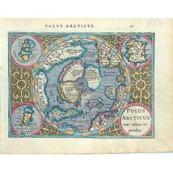
Polus Arcticus cum vicinis regionibus.
Early map of the North Polar regions. Shows the mythical land masses near the pole, the clearly navigable NW and NE passages, a massive California and marvelous detail in...
Place & Date: Amsterdam, 1610
Selling price: ????
Please login to see price!
Sold in 2014
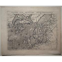
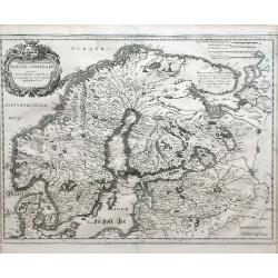
Scandia Sive Regionies Septentrionales.
A detailed map of Scandinavia with Greenland, parts of the North Pole and North America by Magini (1555-1617), from 'Geographiae, tum veteris, tum novae, volumina duo., p...
Place & Date: Arnhem, 1617
Selling price: ????
Please login to see price!
Sold in 2018
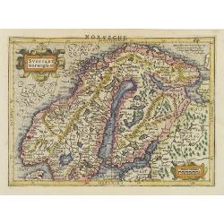
Suecia et Norvegia ect.
Small map of Scandinavia, surrounded by text in Dutch. On verso a copperplate engraving on text leaf depicting a half length oval portrait of "Gustavus D G Sveciae G...
Place & Date: Amsterdam, Cloppenburch, 1621
Selling price: ????
Please login to see price!
Sold
Suecia et Norvegia cum confiniis.
One of the oldest foreign maps of Scandinavia was designed by Lieven Algoet, a poet, calligrapher and cartographer from Ghent, who died in 1547. Mercator's map has the sa...
Place & Date: Amsterdam, 1630
Selling price: ????
Please login to see price!
Sold in 2015
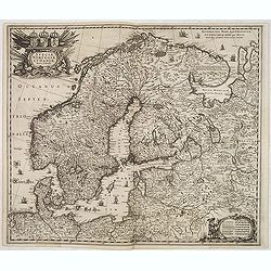
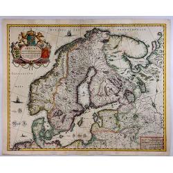
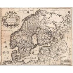
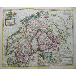
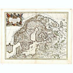
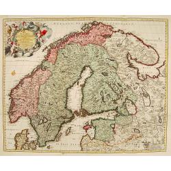
Sueciae, Norvegiae et Daniae Nova Tabula.
Signed lower right. A decorative map of the whole of Scandinavia with a large title cartouche and a decorative scale cartouche, and many ships in the seas and little figu...
Place & Date: Amsterdam, 1640
Selling price: ????
Please login to see price!
Sold in 2020
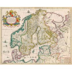
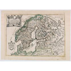
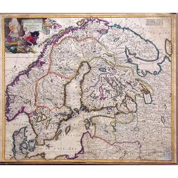
Svecia, Dania, et Norvegia regnae Europe septentrionale.
Famous map of Scandinavia, copied from the wall map (1620) by the Swedish cartographer Andreas Bure (1571-1646).More about Willem Blaeu. [+]
Place & Date: Amsterdam, 1644
Selling price: ????
Please login to see price!
Sold in 2017
Svecia, Dania et Norvegia, Regna Europa Septentrionalia.
A striking map of the kingdoms of Sweden, Denmark and Norway (Scandinavia), attributed to Anders Bure (1571-1646), a Swedish cartographer and mathematician. Bure, also kn...
Place & Date: Amsterdam, 1644
Selling price: ????
Please login to see price!
Sold in 2018
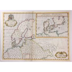
Suecia, Dania et Norvegia, Regna Europae Septentrionalia.
Decorative map of Scandinavia. Latin text on verso.
Place & Date: Amsterdam, 1644-1645
Selling price: ????
Please login to see price!
Sold in 2010
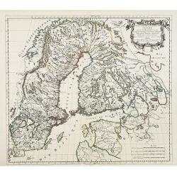
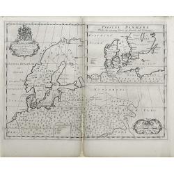
Tabula exantissima Regnoru Suecia et Norvegia
Finely detailed map showing Scandinavia (Denmark, Sweden, Norway, Finland), and White Sea region with a pretty cartouche in the upper left.
Place & Date: Frankfurt, 1649
Selling price: ????
Please login to see price!
Sold in 2010
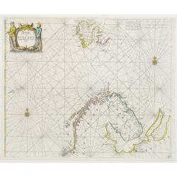
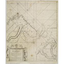
Pascaart Vande zeecusten van Ruslant, Laplant, Finmarcken en Spitzbergen.
It shows the most western part of Russia's north coast, the northernmost part of Scandinavia and Spitsbergen.
Place & Date: Amsterdam 1650
Selling price: ????
Please login to see price!
Sold
Suecia, Dania et Norvegia, Regna Europae Septentrionalia.
Decorative map of Scandinavia.
Place & Date: Amsterdam, 1655
Selling price: ????
Please login to see price!
Sold in 2014
Pascaart vande Oost-Zee beschreven door Willem Ians Blauw ao. 1622.
Very rare chart of the Baltic Sea and the Gulf of Finland. Published in De groote Zee-spiegel. inhoudende een korte Onderswij singe in de konst der zeevaert en eene besch...
Place & Date: Amsterdam, Joan Blaeu, 1655-1658
Selling price: ????
Please login to see price!
Sold in 2010
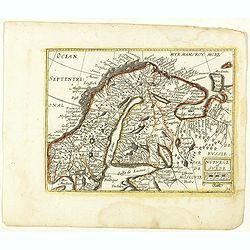
Norvege et Suede. (31).
Scarce map of Norway, Finland and Sweden published by Antoine de Fer in 1661 or 1662 in "Cartes de géographie revues et augmentées". With number 31 in lower r...
Place & Date: Paris, Antoine de Fer, 1657 but 1661 or 1662
Selling price: ????
Please login to see price!
Sold in 2018
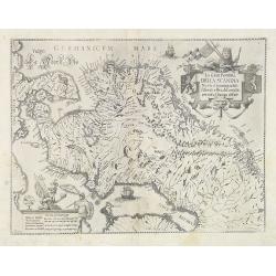
La Gran Penisola DELLA SCANDIA Madre d innumerabili Essercili e Regali Famiglie pertutta l'Europa diffuse.
Scarce map of Scandinavia with decorative cartouche and scale of miles, north orientated to the right. Engraved by Antonio de Piene for "Emmanuele Tesauro's Del Regn...
Place & Date: Turin, 1664
Selling price: ????
Please login to see price!
Sold
Scandinavie ou sont les Estats de Danemark, de Suede & C. . .
Map of Scandinavia prepared by N.Sanson and published by Pierre Mariette. Some contemporary manuscript annotations in brown ink. Published in an early edition of the smal...
Place & Date: Paris, P. Mariette, 1667
Selling price: ????
Please login to see price!
Sold in 2012
Estats de la couronne de SUEDE dans la Scandinavie..
Map of Sweden and Finland, with original or early outline hand-color. Numerous place-names of counties, cities, towns, physical features.
Place & Date: Paris, 1669
Selling price: ????
Please login to see price!
Sold in 2009
Tabula Regnorum Sueciae et Norvegiae.
Map of Sweden and Norway form a composition atlas from ca 1670.
Place & Date: Amsterdam, 1670
Selling price: ????
Please login to see price!
Sold in 2009
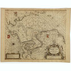
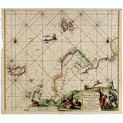
Pas Caart van de Noort Zee Verthoonende in zich alle de Custen en Havens daer rontom gelegen.
An eye-catching chart of the entirety of North Europe's coastline, extending from the Mouth of the Thames and the English Channel and Calais and Dunkirk to Stetin and Chr...
Place & Date: Amsterdam, 1675
Selling price: ????
Please login to see price!
Sold in 2025
La Scandinavia...
Giacomo Rossi's fine late 17th century map of Scandinavia. Issued in Il Mercurio geografico In upper left corner an ornate tittle cartouche. The cartographer was Giacomo ...
Place & Date: Rome, 1678
Selling price: ????
Please login to see price!
Sold in 2017
La Scandinavia...
Giacomo Rossi's fine late 17th century map of Scandinavia. Issued in Il Mercurio geografico In upper left corner an ornate tittle cartouche. The cartographer was Giacomo ...
Place & Date: Rome, 1678
Selling price: ????
Please login to see price!
Sold in 2020
Paskaart Van 't Noordelykste deel der Noort Zee Beginnende van der Neus tot Nova Zembla. . . .
Very fine chart with Iceland to the left and reaching till Nova Zembla, including of Iceland, Spitzbergen, Northern Scotland, Russia and Scandinavia with just a hint of G...
Place & Date: Amsterdam, 1680
Selling price: ????
Please login to see price!
Sold in 2016
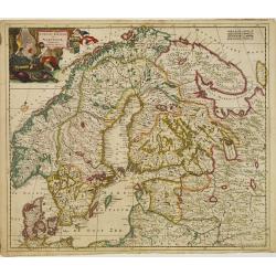
![[Lot of 3 maps] Uplandia, plus a map of the island of Ruegen by W, Blaeu and the General map of Scandinavia by Reinier & Joshua Ottens.](/uploads/cache/82017-250x250.jpg)
[Lot of 3 maps] Uplandia, plus a map of the island of Ruegen by W, Blaeu and the General map of Scandinavia by Reinier & Joshua Ottens.
An attractive map of Upland with Stockholm. With two nice cartouches. Moses Pitt (d.London,1696), planned to publish together with Janssonius' son-in-law, Janssonius van ...
Place & Date: London, 1680
Selling price: ????
Please login to see price!
Sold in 2022
![[No title] Spitzbergen.](/uploads/cache/02427-250x250.jpg)
[No title] Spitzbergen.
Greenland split in two and Wiches Lande at the edge of the map, complete with compass-rose, galleon and monsters. Surrounded by eleven scenes of whaling from capture to b...
Place & Date: London 1680
Selling price: ????
Please login to see price!
Sold in 2020
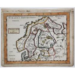
SWEDLAND and NORWAY
A copperplate map of Scandinavia / Baltic from Sir Jonas Moore's "New System of Mathematics" London, Printed by A. Godbid and J. Playford, for Robert Scott, 168...
Place & Date: London, 1681
Selling price: ????
Please login to see price!
Sold in 2019
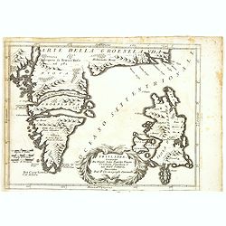
Decouverte de la Groenlande.
An interesting miniature map centered on Iceland and outlining most part of Greenland. Northwest on top. It includes Norway and great part of the British Isles.The sea is...
Place & Date: Paris 1683
Selling price: ????
Please login to see price!
Sold
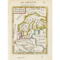
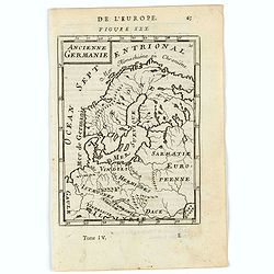
Ancienne Germanie.
Attractive map of Scandinavia from the French text edition of Description d'Univers, 1683. By Allain Manneson Mallet (1630-1706), a well traveled military engineer and ge...
Place & Date: Paris, 1683
Selling price: ????
Please login to see price!
Sold in 2009
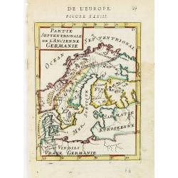
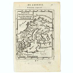
Partie Septentrionale de l'Ancienne Germanie.
Small map of Scandinavia from the French text edition of Description d'Univers, 1683. By Allain Manneson Mallet (1630-1706), a well traveled military engineer and geograp...
Place & Date: Paris, 1683
Selling price: ????
Please login to see price!
Sold in 2009
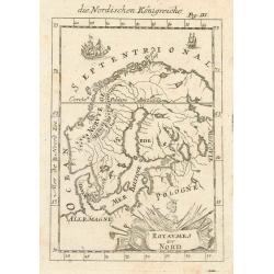
Royaumes du Nord.
Interesting map of Scandinavia.
Place & Date: Paris, 1683
Selling price: ????
Please login to see price!
Sold in 2010
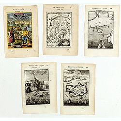
(Five engravings of Scandinavian interest from Description de l\'Univers)
Finely etched prints and maps, entitled : Islande, Isle d'Islande, Suede, Decowerte de la Groenlande, Norvvegiens. From the French text edition of Description d'Univers.....
Place & Date: Paris, 1683
Selling price: ????
Please login to see price!
Sold in 2015
Ancienne Germanie.
A map of ancient Scandinavia and Germany. Title in curtain draped at top. French text on verso.From the original 1683 text edition of "Description d'Univers. . .&quo...
Place & Date: Paris, 1683
Selling price: ????
Please login to see price!
Sold in 2020
Partie Septentrionale de l'Ancienne Germanie.
A charming map of ancient Scandinavia. Title in curtain draped at top. French text on verso.From the original 1683 text edition of "Description d'Univers. . ." ...
Place & Date: Paris, 1683
Selling price: ????
Please login to see price!
Sold in 2020
Accuratissima regnorum sueciae, daniae et norvegiae tabula.
Uncommon map of the Scandinavian peninsula with a large, very decorative title cartouche in upper left corner.Includes Sweden, Denmark, Norway and a part of Russia.
Place & Date: Amsterdam, 1690
Selling price: ????
Please login to see price!
Sold in 2014
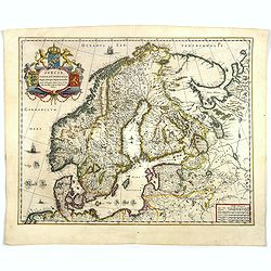
Regni Sueciae Tabula Generalis, divisia in Suediae, Gothiae. . .
An attractive and detailed map of Scandinavia, centered on Finland, including parts of Sweden, Norway and Russia. Nicely colored to accentuate the seas, mountains, lakes ...
Place & Date: Amsterdam, 1690
Selling price: ????
Please login to see price!
Sold in 2019
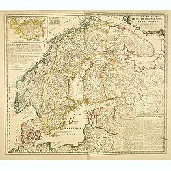
![[ Lot of 9 maps and plans] Novissima nec non Perfectissima Scandinaviae Tabula](/uploads/cache/18177-(3)-250x250.jpg)
[ Lot of 9 maps and plans] Novissima nec non Perfectissima Scandinaviae Tabula
Frederick de Wit's large and detailled map of Scandinavia. Embellished with a large, decorative title-cartouche.From Frederick de Wit's' Atlas Maior'. Frederik de Wit (16...
Place & Date: Amsterdam, 1690
Selling price: ????
Please login to see price!
Sold in 2022
Les Royaumes De Suede, de Danemarck et De Norwege Divisez en plusieurs Provincez, et Gouvernemens, etc. selon les Memoires de Bxxx de Scheffer, et de plusieurs autres Corrigee et augmentez apr le Sr. de Tillemon . . .
Rare map of Scandinavia and the Baltic with inset map of Iceland. Published by Jean Baptiste Nolin, the Geographer to the King of France. With large text panels giving ge...
Place & Date: Paris, 1691
Selling price: ????
Please login to see price!
Sold in 2014
![[Lot of 8 maps of Denmark and Scandinavia] Le Royaume de / Danemark / subdicise en ses principales provences.via](/uploads/cache/18385-(4)-250x250.jpg)
[Lot of 8 maps of Denmark and Scandinavia] Le Royaume de / Danemark / subdicise en ses principales provences.via
Alexis-Hubert Jaillot (1632-1712), French cartographer. He joined the Sanson heirs and redrew Nicolas Sanson's maps on a larger scale. 'Atlas Nouveau' (1674), sea-atlas '...
Place & Date: 1692
Selling price: ????
Please login to see price!
Sold in 2022
Scandinavia or the Kingdoms of Denmark, Sueden, Norway & Lapland.
A nice late seventeenth century map of Scandinavia, as it was then. It depicts Sweden occupying modern day Finland, and shows part of Iceland, England and Ireland, all of...
Place & Date: London, 1695
Selling price: ????
Please login to see price!
Sold in 2018
Accuratissima..Sueciae, Daniae et Norvegiae, Tabula.
Signed lower right with privilege. A delicately colored map of Scandinavia with a large title cartouche.
Place & Date: Amsterdam 1696
Selling price: ????
Please login to see price!
Sold
Accuratissima regnorum Sueciae, Daniae et Norvegiae, Tabula.
Uncommon map of Scandinavia with a large title cartouche in upper left corner. Signed lower right with privilege.Including Sweden, Denmark, Norway and small part of Russi...
Place & Date: Amsterdam, 1696
Selling price: ????
Please login to see price!
Sold in 2011
Frislanda, Scoperta da Nicolo Zeno Patritio Veneto Creduta Favolosa, o nel Mare Somersa . . .
A fine map of the mythical island of "Frislandia", based upon the writings of Nicolo Zeno.Frislanda, which was purportedly discovered by the Zeno brothers in a ...
Place & Date: Venice, 1696
Selling price: ????
Please login to see price!
Sold in 2013
Isola Di Mayen Scoperta l'Anno 1614 . . .
A fine map of Jan Mayen Island, which was discovered in 1614 by a Dutch whaling captain, northeast of Iceland.A large volcano is shown. The map has many Dutch names.The r...
Place & Date: Venice, 1696
Selling price: ????
Please login to see price!
Sold in 2020
Nieuwe gelyk-gradige Paskaart van Muskovien in grootbestek. Begrypende Noorwegen, Finmarken, Lapland en Rusland. Strekkende van Hitland tot Ysland, Beren Yland. . .
Rare sea chart map of ?Muskovien?: comprising northern parts of Norway, Finland and Russia, with insets of Kola peninsula and the course of the Archangel (Dwina) rivers. ...
Place & Date: Amsterdam, 1697
Selling price: ????
Please login to see price!
Sold in 2008
La Scandie.. Suede, Danemarc & Norvegue.
Fine map including Sweden, Norway, Denmark and Finland. Decorative title cartouche with dedication to Charles XII. Prepared by Nicolaas Visscher, a uncommon re-issue by P...
Place & Date: Amsterdam 1700
Selling price: ????
Please login to see price!
Sold
A New Map of Denmark, Norway, Sweden, & Moscovy shewing their present general divisions, chief cities or towns, rivers and mountains & c.
Fine map of Scandinavia and Russia from 1700, dedicated to the Duke of Glocester. Cartouche with English coat of arms is in the upper left corner.
Place & Date: London, 1700
Selling price: ????
Please login to see price!
Sold in 2010
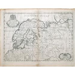
A New Map of Ancient Scandinavia together with as much more of y Northern Part of Ancient Europe as Anvers to Present Denmark & Moscovia
Map of Scandinavia, with an inset map of Denmark, from Edward Wells' "A New Sett Of Mapps Of Ancient And Present Geography ..." Wells was a teacher of mathemati...
Place & Date: Oxford, 1700
Selling price: ????
Please login to see price!
Sold in 2010
A New Map of Ancient Scandinavia together with as much more of y Northern Part of Ancient Europe as Anvers to Present Denmark & Moscovia
A map of Scandinavia, with an inset map of “Present Denmark”, from Edward Wells' "A New Sett Of Mapps Of Ancient And Present Geography ...". The engraver of...
Place & Date: Oxford, 1700
Selling price: ????
Please login to see price!
Sold in 2018
![[Map of Scandinavia] La Scandinavie, et les Environs.](/uploads/cache/82018-250x250.jpg)
[Map of Scandinavia] La Scandinavie, et les Environs.
An attractive large-format map of Scandinavia. Embellished with two cartouches by Jaillot, H-J.
Place & Date: Paris, ca 1700
Selling price: ????
Please login to see price!
Sold in 2019