Browse Listings in Europe > Russia / Baltic / Black Sea region > Russia Provinces
(Title in Russian : the Baltic Sea with Tallinn with the island of Naissaar.)
This rare chart of the Baltic Sea with the town of Tallinn and with the island of Naissaar.Based on the work Gavril Andreyevich Sarychev (1763-1831) which work was expend...
Date: Saint Petersburg, 1846-1849
Selling price: ????
Please login to see price!
Sold in 2013

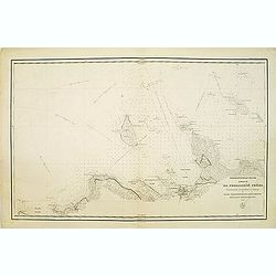
Kamchatka according to A.Erman . . .
FIRST EDITION Map of the Kamchatka Peninsula, Siberia, from Gazetteer of the World. Drawn by Augustus Petermann, engraved by G. H. Swanston.
Date: London / Edinburgh, 1850
Selling price: ????
Please login to see price!
Sold in 2025
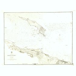
Baltic Gulf of Finland KRONSTAT from the Russian survey . . .
Large scale chart of the island of Kronstat in the Gulf of Finland. With also coast of Finland. With soundings, scale and vignette of Hydrographical office. Chart nr. 221...
Date: London, 1853
Selling price: ????
Please login to see price!
Sold in 2021
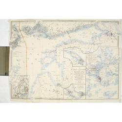
The Gulf of Finland and Baltic Sea with the fortified places from Stockholm to St.Petersburg. . . / Gulf of Bothia. / Cronstadt and St. Petersburg. . . / The harbour & entrances of Sweaborg and Helsingfors. . . Cronstadt. . .
Folding map of Gulf of Finland with several inset maps. James Wyld (the younger) was geographer to the Queen and H.R.H. Prince Albert. Joined his father's business in 183...
Date: London, 1854
Selling price: ????
Please login to see price!
Sold in 2015
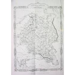
RUSSIA in EUROPE
This is the uncommon and slightly later edition by Rapkin based on Tallis' maps. The vignettes have been removed and the map is issued in black and white. A rare and desi...
Date: London, 1855
Selling price: ????
Please login to see price!
Sold in 2008
![[Tittle in Russian] Kapta...(Taymyr Peninsula)](/uploads/cache/29138-250x250.jpg)
[Tittle in Russian] Kapta...(Taymyr Peninsula)
Chart of the Russian peninsula of Taymyr in Northern Russia. Lithograph, in two sheets joined as one. This map in great detail appears to be a Russian government chart. I...
Date: Moscow, 1874
Selling price: ????
Please login to see price!
Sold in 2014
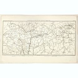
Carte de la Route de Wilna à Moscou.
Detailed road map of the European part of Russia, centered on Minsk, Smolensk and Moscow in the upper right corner, prepared by A. H. Basset, rue Saint-Jacques, no. 55, P...
Date: Paris, 1880
Selling price: ????
Please login to see price!
Sold in 2023
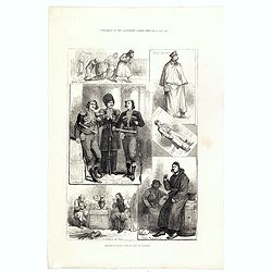
Sketches in Russia: Popular life and manners.
Six images on one plate of Russian in typical costumes published in "The Illustrated London News" of 1880.
Date: London, 1880
Selling price: ????
Please login to see price!
Sold in 2016
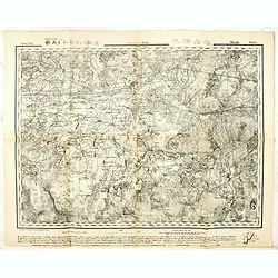
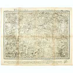
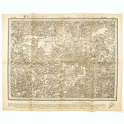
Government Minsk. - Russland 1:126,000 V. XVII.6.
Folding military topographic map of part of Belarus, issued by the General Staff of the German Army. Scale 1:126000 (3 km (Werst) in 1 inch). Centered on Sluzk.Along uppe...
Date: Germany, 1915
Selling price: ????
Please login to see price!
Sold in 2021
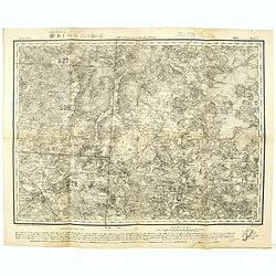
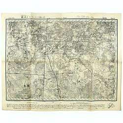
Government Minsk u. Wilna Mirr Blatt 5. - Russland 1:126,000 V. XVI.5.
Folding military topographic map of part of Belarus, issued by the General Staff of the German Army. Scale 1:126000 (3 km (Werst) in 1 inch). Centered on Mir.Along upper ...
Date: Germany, 1915
Selling price: ????
Please login to see price!
Sold in 2021
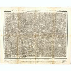
Government Minsk. Kopyl Blatt 6. - Russland 1:126,000 V. XVI.6.
Folding military topographic map of part of Belarus, issued by the General Staff of the German Army. Scale 1:126000 (3 km (Werst) in 1 inch). Centered on Schazk.Along upp...
Date: Germany, 1915
Selling price: ????
Please login to see price!
Sold in 2021
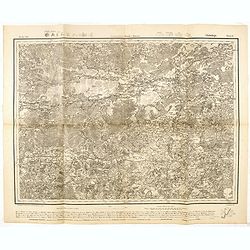
Government Minsk. Klezk Blatt 5. - Russland 1:126,000 V. XVII.5.
Folding military topographic map of part of Belarus, issued by the General Staff of the German Army. Scale 1:126000 (3 km (Werst) in 1 inch). Centered on Sinjawka.Along u...
Date: Germany, 1915
Selling price: ????
Please login to see price!
Sold in 2021
Government Wilna u. Kowno Widsy Blatt 5. - Russland 1:126,000 V. XII.5.
Folding military topographic map of part of Belarus, issued by the General Staff of the German Army. Scale 1:126000 (3 km (Werst) in 1 inch). Centered on Swenzjany.Along ...
Date: Germany, 1915
Selling price: ????
Please login to see price!
Sold in 2016
Government Minsk u Kowno. Glubokoje Blatt 6.- Russland 1:126,000 V. XII.6.
Folding military topographic map of part of Belarus, issued by the General Staff of the German Army. Scale 1:126000 (3 km (Werst) in 1 inch). Centered on Glubokoje.Along ...
Date: Germany, 1915
Selling price: ????
Please login to see price!
Sold in 2016
GovernmentWilna u. Minsk. Dokschitzy Blatt 6.- Russland 1:126,000 V. XIII.6.
Folding military topographic map of part of Belarus, issued by the General Staff of the German Army. Scale 1:126000 (3 km (Werst) in 1 inch). Centered on Budslaw.Along up...
Date: Germany, 1915
Selling price: ????
Please login to see price!
Sold in 2016
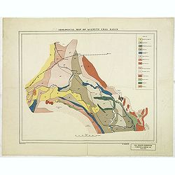
Geological map of Kuznetz coal basin.
American geological map of the Russian Kuznetsk Coal zone, published by R. Martens & Co. From New York. color key in upper The development of the coal fields of Kuzne...
Date: New-York, ca. 1916
Selling price: ????
Please login to see price!
Sold in 2012