Browse Listings in Europe > Mediterranean & Islands > Mediterranean
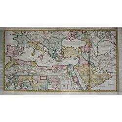
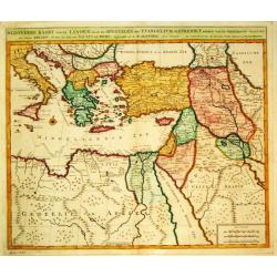
Carte de l\' Empire Othoman consideréedans les Etats de cette Puissance, et Etats qui l\' avoisinent ou qui luy sont tributaires. / Carte pour servir a l\' Histoire Universelle / Carte de la Grèce.
Henri Abraham Chatelain was a Amsterdam-based geographer and publisher. His main product is the 'Atlas Historique et Méthodique', in seven volumes, published between 171...
Place & Date: Amsterdam, 1710 / 1720
Selling price: $550
Sold in 2009
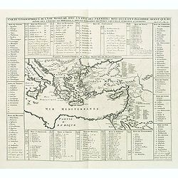
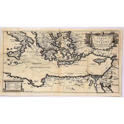
Carte geographique de l'Asie mineure avec un etat des premiers rois. . .
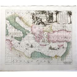
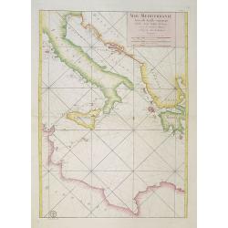
Map of the Mediterranean. This impressive engraving is a wonderful example of Chatelain’s elegant plates from his "Atlas Historique, Ou Nouvelle Introduction A L�...
Place & Date: Amsterdam, ca. 1720
Selling price: $60
Sold in 2012
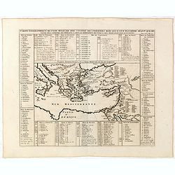
Carte geographique de l'Asie mineure avec un etat des premiers rois. . .
Map of the Mediterranean. This impressive engraving is a wonderful example of Chatelain’s elegant plates from his "Atlas Historique, Ou Nouvelle Introduction A L�...
Place & Date: Amsterdam, ca. 1720
Selling price: $120
Sold in 2022
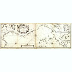
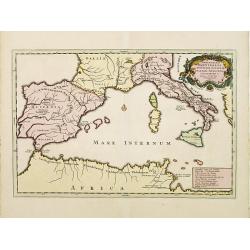
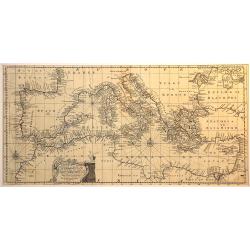
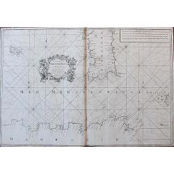
Nouvelle Carte De Cotes De Catalogne, Rousiilon, Languedoc, Provence, D'Italie et Partie De L'Isle De Corce . . .
Striking two-sheet chart of the Mediterranean Coast, from Catalonia to the mouth of the Tiber River in Italy, showing most of Corsica and the island of Elba, with 6 large...
Place & Date: Marseille, 1715-1726
Selling price: $1500
Sold
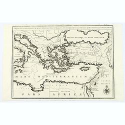
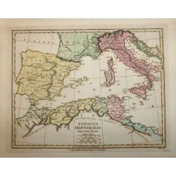
Expeditiones Hannibalis per Hispaniam, Galliam, Italiam, Africam &cc..
Map covering the Eastern part of the Mediterranean Basin as far as the Adriatic Sea. It illustrates the route of Hannibal through Northern Africa and southern Europe as f...
Place & Date: Amsterdam 1730
Selling price: $200
Sold
Tabula Peculiaris Regionum, quas Apostoli Perlustrarunt. . .
This map shows the entire eastern Mediterranean, with many ancient places named along the coast lines. This map depicts Paul the Apostle's journey from Jerusalem to Rome,...
Place & Date: Pars, ca. 1730
Selling price: $20
Sold in 2020
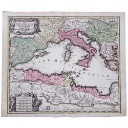
Mare Mediterraneum juxta Regna et Provincias, quas Alluit Distinctum et Cognominatum.
An old colored copperplate map of the middle west Mediterranean Sea. It shows the neighboring countries of Spain, Italy, the Balkans, Greece, as well as the north coast o...
Place & Date: Ausburg, ca. 1730
Selling price: $260
Sold in 2019
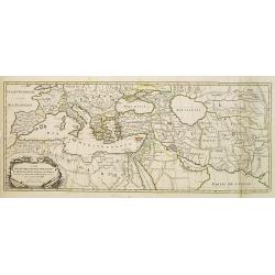
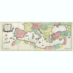
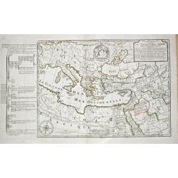
Carte Des Quatre Grandes Monarchies, des Assirieens, des Perse, des Grecs, et des Romains.. Celle Flavius Joseph .
Map covering the entire Mediterranean Basin and the Middle East as far as the borders of India. Outline coloring shows the political division.
Place & Date: Amsterdam 1740
Selling price: $200
Sold
Byzondere Kaart van de Landen daar de Apostelen het Evangelium Gepredikt hebben?en van de weg van Paulus naar Rome.
A map of the eastern Mediterranean. With the track of St. Paul\'s voyage from Cesaere to Rome. From \' Hisoire du Vieux et du Nouveau Testament\', published by Johannes C...
Place & Date: Amsterdam, c. 1740
Selling price: $240
Sold
Carte des Voyages de Telemaque.
This interesting map is from “The Adventures of Telemachus” which is a didactic French novel by Fénelon, the Archbishop of Cambrai, and tutor to the seven-year-old ...
Place & Date: Paris, 1742
Selling price: $57
Sold in 2019
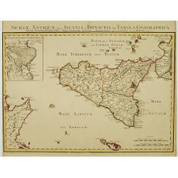
Siciliae Antiquae quae et Sicania et Trinacria dicta tabula geographica.
Detailed map of Sicily in outline color. Shows forests, a smoking Mount Etna, etc. Covers also Malta and Lipari Islands. Relief shown pictorially. Inset map: Veterum Syra...
Place & Date: Amsterdam c. 1745
Selling price: $265
Sold
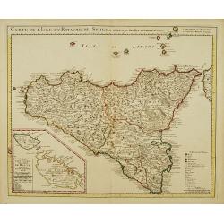
Carte de l'Isle et Royaume de Sicile.
Large, highly detailed map of Sicily. Shows illustrated topography with fortresses, churches, abbeys, ancient ruins, and aqueducts. The most prominent feature is the larg...
Place & Date: Amsterdam c. 1745
Selling price: $335
Sold
Orientalior Districtus Maris Mediterranei / t'Ooster Gedeelte van de Middelandse Zee.
A sea chart of the Eastern Mediterranean, from Sardinia and Corsica to Syria and the Holy Land, centered on Greece. A very nice cartouche at top centre depicting a confro...
Place & Date: Amsterdam, 1745
Selling price: $555
Sold in 2020
An accurate chart of the Mediterranean and Adriatic Sea. . .
An excellent early engraving of the Mediterranean and Adriatic Sea.
Place & Date: London, 1747
Selling price: $150
Sold in 2014
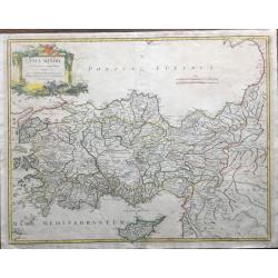
Asia Minor In Suas Partes, Seu Provincias Divisa . . .
Very large, very detailed map showing Cyprus, Asia Minor and contiguous Iùislands and the Black Sea region, from De Vaugondy's Atlas Universel.
Place & Date: Paris, 1756
D' Reyse des Apostels Pauli na Roomen.
Dutch so-called 'Staten' bibles, published between 1637 and c. 1760, contained 5 maps: The World, 'Paradise', The Perigrinations, The Promised Land Canaan, The Travels of...
Place & Date: Amsterdam / Leiden, R. & J. Wetstein / W. Smith / S. Luchtmans, 1757
Selling price: $375
Sold
![[untitled] Balearic: Isle Fromentiere & Ivice](/uploads/cache/90490-250x250.jpg)
[untitled] Balearic: Isle Fromentiere & Ivice
Important chart of the island of Formentera and the southern part of Ibiza. Published in Roux's influental "Recueil des principaux plans des ports et rades de la Med...
Place & Date: Paris 1764
Selling price: $70
Sold in 2008
The Coast of the Mediterranean Sea from C. Tenelles to C. Bon, including the Islands of Minorca and Sardinia.
Very rare sea-chart showing the area from Minorca until the coast of Sicily, including most of Sardinia, Pantelleria, and a part of North Africa. With many place names al...
Place & Date: London, 1764
Selling price: $250
Sold in 2018
Mer Mediterranée Seconde Feuille contenant L' Italie, Sicile, Golphe de Venise.. Barbarie.
A well engraved and highly detailed chart of the eastern part of the Mediterranean, centered on Italy. Showing soundings, anchorage's, channels, shoals, navigational sigh...
Place & Date: Paris, 1765
Selling price: $345
Sold in 2018
Carte Geographique representant la Mer Mediterranée ou la seconde Partie du Theatre de la Guerre entre les Russes et les Turcs C'est à dire les Roiaumes, les Etâts, les Provinces. . .
A beautiful map of the Mediterranean Sea. Embellished with three compass roses and sailing vessels, including a scene on a naval battle in the Atlantic off of Gibraltar.T...
Place & Date: Augsbourg, 1770
Selling price: $2050
Sold in 2014
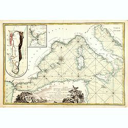
.Carte reduite de la partie occidentale de la mer Mediterranée.
Scarce chart of the Mediterranean published by André Basset. With insets of "Detroit de Gibraltar." and "Plan de Gibraltar". According to the title &...
Place & Date: Paris, 1780
Selling price: $600
Sold in 2016
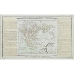
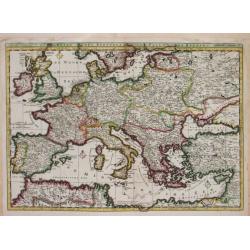
Turquie Européenne, Avec les Pays limitrophes..
Copper engraved map centered on Greece, extending northwards and eastwards to include the Balkans and Ukraine as well as Cyprus.The map is flanked by two columns of Frenc...
Place & Date: Paris, 1790
Selling price: $120
Sold in 2012
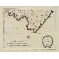
Der Insel Majorca Südlicher Theil. . .
Map showing the southern part of Majorca and just off the south coast of Mallorca, the island of Cabrera. Including cities of Palma, Santueri, Estarella. Published by Fra...
Place & Date: Vienna, 1791
Selling price: $100
Sold in 2010
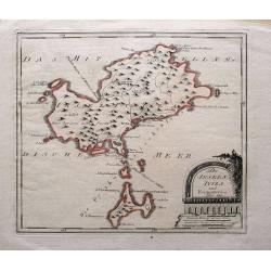
Die Inseln Iviza und Formentera.
Very rare map showing Ibiza and Formentera. With interesting notes in German: Formentera being uninhabited; scattered houses on Ibiza; passage for large ships;...
Place & Date: Vienna, 1791
Selling price: $300
Sold in 2015
Carte de la Geographie Sacree pour L ' Ancien Testament. 1716.
Pierre Moullart-Sanson, grandson of Nicolas Sanson Sr., succeeded by his nephew Gilles Robert de Vaugondy. Charles François Delamarche (1740-1817), successor to Didier R...
Place & Date: Paris, 1797
Selling price: $150
Sold
EXPEDITIO HANNIBALIS POENORUM DUCIS
A copper engraved map by John Roper which was published in "Wiklinson's Atlas Classica" in 1803. The map covers the Mediterranean & Islands, Tunisia, Spain,...
Place & Date: London, 1803
Selling price: $50
Sold in 2016
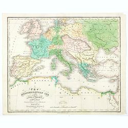
The Mediterranean Sea with the Countries on its Borders.
An interesting and unusual map of the Mediterranean Sea, and her adjoining countries, published in America during the first half of the nineteenth century as part of Hart...
Place & Date: America, ca 1826
Selling price: $21
Sold in 2020
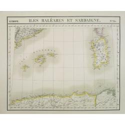
Europe. Isles Baléares et Sardaigne. N.25.
Detailed map including Baleares and Sardinia. Along the lower part the coast line of Algeria.From his famous Atlas Universel . This atlas was one of the most remarkable w...
Place & Date: Brussels, 1825-1827
Selling price: $450
Sold in 2013
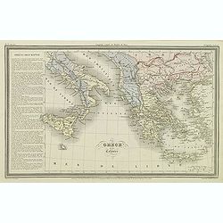
Grèce et ses colonies.
Finely engraved map of Greece, including Macedonia and lower part of Italy, prepared by A.H.Dufour and engraved by Giraldon-Bovinet. Published by Jules Renouard in his un...
Place & Date: Paris, Jules Renouard, ca.1840
Selling price: $40
Sold in 2011
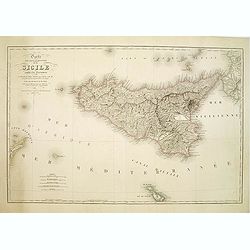
Carte Physique et Routiere de la Sicile..
A very nice exemplary centred on Sicily. Printed by L.Turgis active in Paris and New York. Malta is represented on the bottom.
Place & Date: Paris, 1860
Selling price: $100
Sold
![Mer Méditerranée - Partie Ouest. [5321]](/uploads/cache/23547-250x250.jpg)
Mer Méditerranée - Partie Ouest. [5321]
Large chart centered on the western part of the Mediterranean Basin from the Strait of Gibraltar as far as the Dalmatian coast, with soundings indicated in meters.Surroun...
Place & Date: Paris [1914] corrections to 1931
Selling price: $180
Sold
![Mer Méditerranée - Partie Est. [5322]](/uploads/cache/23548-250x250.jpg)
Mer Méditerranée - Partie Est. [5322]
Large chart centered on the eastern part of the Mediterranean, with soundings indicated in meters.Surrounded by 28 inset plans of the main European African and Asian town...
Place & Date: Paris [1914] corrections to 1931
Selling price: $285
Sold
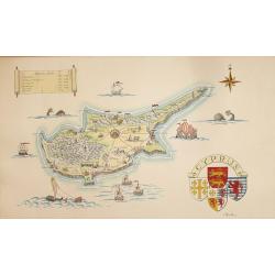
A Pictorial Map of Cyprus.
An attractive hand painted map of Cyprus a scroll cartouche has the Historical dates of the Islands occupation, the map centers on Nicosia. The sea has galleons, sea mons...
Place & Date: ca. 1950
Selling price: $95
Sold in 2014
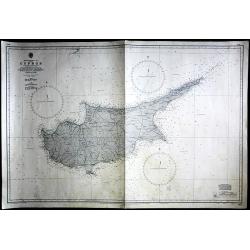
Cyprus
Large Admiralty sea chart of Cyprus.
Place & Date: London, 1964
Selling price: $60
Sold in 2017