Browse Listings in Europe > Mediterranean & Islands > Mediterranean
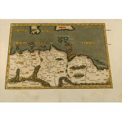
Aphricae tabula secunda continet
Untitled trapezoidal Ptolemaic woodcut map of North Africa. From the 1541 Vienne (Dauphiné) edition of Ptolemy\'s Geographia published by Gaspar Trechsel and sold by H...
Place & Date: Vienne, 1541
Selling price: $500
Sold in 2009
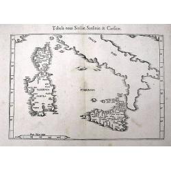
Tabula nova Siciliae, Sardiniae, & Corsicae
An early woodcut Ptolemaic map of Corsica, Sardinia, Sicily, and southern Italy. With several towns and islands named. The active volcano Etna is shown with flames.
Place & Date: Vienne, 1541
Selling price: $120
Sold in 2016
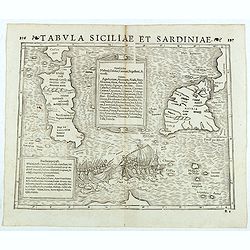
Tabula Siciliae et Sardiniae. (Sicily and Sardinia)
Double-page woodcut Ptolemaic-style map by Sebastian Münster figuring Sicily and Sardinia, published in the edition of Strabo by Henri Petri in 1571."Strabonis reru...
Place & Date: Basle, Henri Petri, 1571
Selling price: $155
Sold in 2018
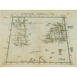
Europae Tabula VII.
Map representing Sardinia and Sicily. Also showing Malta, southern part of Corsica, northern part of Africa and western part of Italy.From La Geografia Di Clavdio Tolomeo...
Place & Date: Venise 1574
Selling price: $130
Sold
![Calaris [on sheet with] Malta [and] Rhodus [and] Famagusta.](/uploads/cache/33682-250x250.jpg)
Calaris [on sheet with] Malta [and] Rhodus [and] Famagusta.
One sheet with very desirable and early town-plans of four Mediterranean island capitals—Cagliari (Sardinia), Valletta (Malta), Rhodes, and Famagusta (Cyprus). "C...
Place & Date: Cologne, (1572) 1577
Selling price: $550
Sold in 2015
-250x250.jpg)
Melita
One of the first delineations of the island of Malta.
Place & Date: Basel, ca. 1578
![[Lot with 12 maps of the Mediterraneans and Egypt.] Aegypti Recenttior Carthageni / General Karte des Roemischen Reichs](/uploads/cache/83963-250x250.jpg)
[Lot with 12 maps of the Mediterraneans and Egypt.] Aegypti Recenttior Carthageni / General Karte des Roemischen Reichs
A map of the Middle East and the Mediterranean. Taken from 'Algemeine Welthistorie (der Neuern Zeiten)', edited by S.J. Baumgarten, J.S.Semler a.o. Abraham Ortelius...
Place & Date: Antwerp, c. 1580
Selling price: $198
Sold in 2022
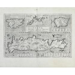
Creta Iouis magni, medio iacet insula ponto.
Fantastic map of islands of the Mediterranean by Ortelius; a large map of Crete is at the bottom half of the sheet, with smaller maps of Corsica, the Greek Islands and Sa...
Place & Date: Antwerp, 1584
Selling price: $200
Sold in 2010
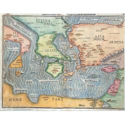
Tafel Der Lender Darin Der Apostel Paulus Geprediget Hat.
The Eastern Mediterranean, from the "Itinerarium Sacrae Scripturae", showing Italy, Sicily, Greece, Cyprus, Asia Minor, the Holy Land and North Africa, with cit...
Place & Date: Magdeburg, 1585
Selling price: $400
Sold in 2014
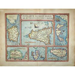
Insularum Aliquot Maris Mediterranei Descriptio.
Insularum Aliquot Maris Mediterranei Descriptio. Cum priuilegio'Sicily, Sardegne, Corfv, Zerbi, Elba, Malta. Six early maps on one sheet. Including the islands of Sicily,...
Place & Date: Antwerp, 1587
Selling price: $650
Sold in 2017