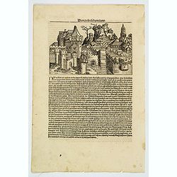
Von Polnischem land.
A wonderful early woodblock view of this Polish or Prussian city, engraved at the end of the fifteenth century in Germany. A page from the richest illustrated Incunable, ...
Place & Date: Nuremberg, 1493
Selling price: $150
Sold in 2019
![[Lot of 7 leaves of Prussia, Gdansk and Riga]](/uploads/cache/48297-250x250.jpg)
[Lot of 7 leaves of Prussia, Gdansk and Riga]
Seven text pages illustrated with wood block prints relating to Poland, Prussia and Latvia with a small view of Riga. From the 1552 Latin text edition of Münster's Cosmo...
Place & Date: Basel, 1552
Selling price: $50
Sold in 2022
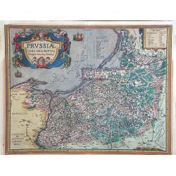
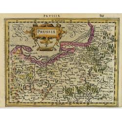
Prussiae vera descriptio.
Map of Poland, oriented to the North. Prepared by the cartographer Caspar Henneberger. From "Theatrum Orbis Terrarum Abrahami Ortelii Antverp".
Place & Date: Antwerpen, 1590
Selling price: $360
Sold in 2015
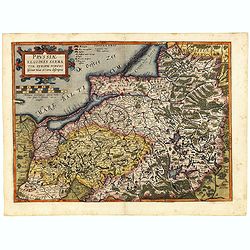
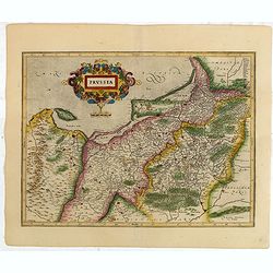
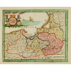
Prussiae Regionis Sarmatiae Europae Nobilissimae Novaet vera descriptio . . .
Nice example of the first edition of De Jode's map of Prussia, from the 1593 edition of De Jode's atlas.The present map is an entirely new addition to the second De Jode ...
Place & Date: Antwerp, 1593
Selling price: $1600
Sold in 2018
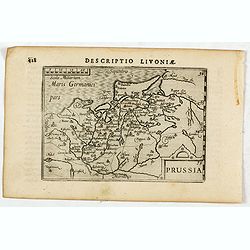
Descriptio Livoniae / Prussia.
A rare miniature map of the area which is now the modern Poland. Title cartouche on the lower right corner.First published in 1598 in his Caert-Thresoor, the plates were ...
Place & Date: Amsterdam, Cornelis Claes, 1606
Selling price: $350
Sold in 2016
Prussia.
Attractive map of Prussia, embellished with a strap work title-cartouche, from the first French-text edition of Jodocus Hondius' Atlas Minor.Shortly after the publication...
Place & Date: Amsterdam, 1608
Selling price: $90
Sold in 2009
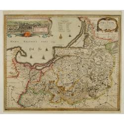
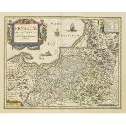
Tabula Prussiae eximia cura conscripta per Casparum Henneberch ..
Very fine and uncommon map of Prussia, prepared by Caspar Henneberger (1592-1600) in 1576. Engraved by Abraham Goos. In upper left corner inset view of Köningsberg (Kali...
Place & Date: Amsterdam 1630
Selling price: $1250
Sold
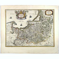
Prussia .
Important early map showing coast of Baltic Sea in Prussia, today Poland, prepared by the German cartographer Gaspher Henneberg of Erlich. Embellished with a large strapw...
Place & Date: Amsterdam, 1630
Selling price: $100
Sold in 2015
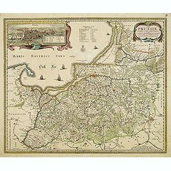
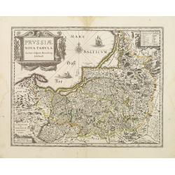
Tabula Prussiae eximia cura conscripta per Casparum Henneberch. . .
Very fine and scarce map of Prussia, prepared by Caspar Henneberger (1592-1600) in 1576. Engraved by Abraham Goos. In upper left corner inset view of Köningsberg (Kalini...
Place & Date: Amsterdam, 1630
Selling price: $700
Sold in 2012
Prussiae nova tabula.
As indicated in the title cartouche, the map was prepared by the German cartographer Gaspar Henneberg of Erlich.As Willem Blaeu died in 1638 most of his maps are actually...
Place & Date: Amsterdam, 1638
Selling price: $750
Sold in 2010
Prussia accurate descriptia a Gasparo Henneberg Erlichensi.
Prussia and the Baltic Region, with two large decorative cartouches, coat of arms, and three sailing ships. As indicated in the title cartouche, the map was prepared by t...
Place & Date: Amsterdam, 1644
Selling price: $500
Sold in 2017
Prussiae nova tabula.
As indicated in the title cartouche, the map was prepared by the German cartographer Gaspher Henneberg of Erlich.
Place & Date: Amsterdam 1645
Selling price: $130
Sold
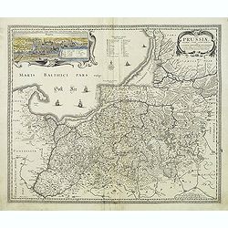
Tabula Prussiae eximia cura conscripta per Casparum Henneberch ..
Very fine and uncommon map of Prussia, prepared by Caspar Henneberger (1592-1600) in 1576. Engraved by Abraham Goos. In upper left corner inset view of Köningsberg (Kali...
Place & Date: Amsterdam, 1660
Selling price: $500
Sold in 2013
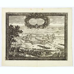
Thorunium Primaria Prussiae Regal Urbis. . .
A decorative battle plan, showing the army of King Charles X Gustav of Sweden. Having routed the Polish armies where ever he met, them Charles X Gustav finally turned his...
Place & Date: Nuremberg, 1696
Selling price: $55
Sold in 2019
Regni Prussiae accurata delineatio.
Uncommon map of Prussia. The originally colored title cartouche is surrounded by mythological figures. From Atlas Portatif.
Place & Date: Nuremberg 1724
Selling price: $55
Sold
Regni Borussiae.. Royaume de Prusse..
Rare map of Prussia, with inset map of the area around Koningsberg.RARE.
Place & Date: Amsterdam, 1740
Selling price: $300
Sold
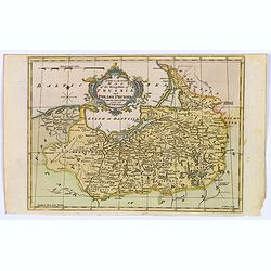
A New & Accurate Map of the Kingdom of Prussia and Polish Prussia.
The map covers the area from Pomerania east to Lithuania. Shows numerous place names, rivers and topography. Decorated by a decorative title cartouche. Compass rose and m...
Place & Date: London, 1765
Selling price: $25
Sold in 2021
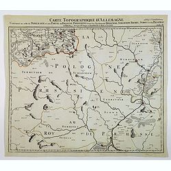
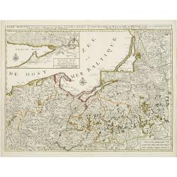
Carte Topographque D'Allemagne / Contenant un reste de Pomeranie et a Partie de la Pologne Prussiene . . .
A large-scale map of Germany and northern Poland, published by the German Military cartographer Johann Wilhelm Abraham Jaeger, from his Grand Atlas d'Allemagne.This map i...
Place & Date: Frankfurt, 1782
Selling price: $22
Sold in 2021
Prussia.
Uncommon miniature map from Gibson's "Atlas Minimus, or a New Set of Pocket Maps of the several Empires, Kingdoms and States of the known World".
Place & Date: London, 1792
Selling price: $80
Sold in 2011
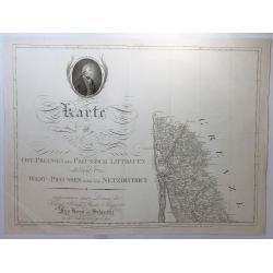
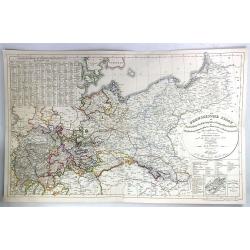
Karte von Ost-Preussen Nebst Presussisch Litthauen und West-Preussen Nebst dem Netzdistrict.
Title section of this important multi sheet map of Prussia, Lithuania and Poland, showing territories of present Lithuania. With a medailon representing the King of Pruss...
Place & Date: Berlin, 1802
Selling price: $11
Sold in 2018
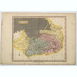
Prussia.
A general map of Prussia, engraved by J.Wallis for Oddy's General Atlas in full original color. Prussia was a historically prominent German state that originated in 1525 ...
Place & Date: London, 1811
Selling price: $15
Sold in 2021
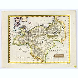
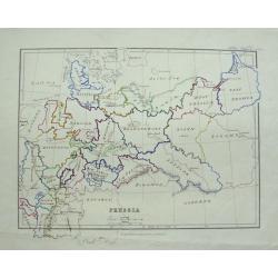
Prussia.
A small, early nineteenth-century map of Prussia. The cities of Berlin, Dantzick and Konigsberg are highlighted in red. Map extent is from Magdeburg in the west to Poznan...
Place & Date: Liverpool, ca 1814
Selling price: $2
Sold in 2021
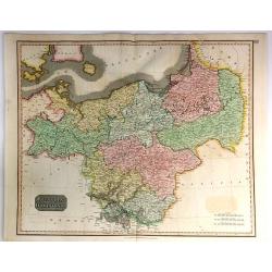
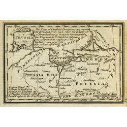
Prussian Dominions
An excellent hand colored 1815 map by the cartographer John Thomson. It depicts Prussia (central and northern Europe). The Map covers from the Baltic Sea to Upper Silesia...
Place & Date: Edinburgh, 1815
Selling price: $37
Sold in 2018
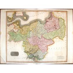
Prussian Dominions.
A vivid hand colored 1815 Thomson map of Prussia or Northern and Central Europe. It comes from Thomson's "NEW GENERAL ATLAS".
Place & Date: Edinburgh, 1815
Selling price: $45
Sold in 2017
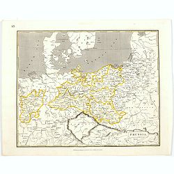
Prussia.
An early nineteenth century map of Prussia, published in Edinburgh. It also shows the southern tip of Sweden, Denmark, and extends as far south as the Carpathian Mountain...
Place & Date: Edinburgh, 1820
Selling price: $20
Sold in 2021
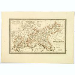
Carte Generale du Royaume de Prusse. . .
A nice French map, typical of the period, of the Kingdom of Prussia, by Vivien, from the "Atlas Universel Pour servir a l'Etude De la Geographie et de l'Histoire Anc...
Place & Date: Paris, 1824
Selling price: $12
Sold in 2021
Prusse et confédération Germanique.
Finely engraved map of Prussia and part of Poland prepared by A.H.Dufour and engraved by Giraldon-Bovinet. Published by Jules Renouard in his uncommon atlas "Le glob...
Place & Date: Paris, Jules Renouard, ca.1840
Selling price: $40
Sold in 2011
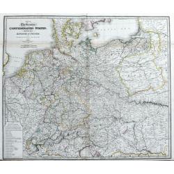
Map of the Germanic Confederated States, including the Kingdom of Prussia, as Settled by the Act of Congress at Vienna, June 9th 1815.
Large and detailed map of central Europe. From France until Poland, Russia, Lithuania and Hungary. And from Denmark until Venice and Belgrade. With areas, roads, rivers, ...
Place & Date: London, c1840
Selling price: $30
Sold in 2020
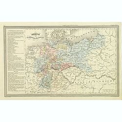
Der Preussische Staat
A fine detailed map of Prussia by Dr. F.W. Streit. Published in Leipzig in 1847. It was produced on two sheets that have been conjoined.
Place & Date: Leipzig, 1847
Selling price: $33
Sold in 2016
Prussia.
Detailed map of Germany, Prussia and Poland, with unique hand-drawn details and borders. Dated 1872 by Alice Welsh. Includes several kingdoms, rivers, and cities.
Place & Date: London, 1872
Selling price: $25
Sold in 2015