Browse Listings in Europe > Germany > Germany General Maps
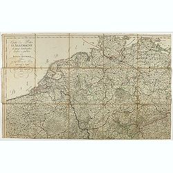
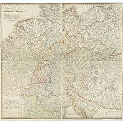
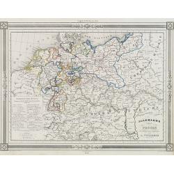
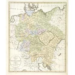
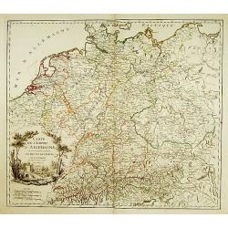
Cartes des Postes d'Allemagne et pays limitrophes. . .
Upper left part of a large detailed post road mapspost route map of Germany. Centered on Bielefeld and showing the cities of Hamburg, Coblenz. And Belgium, The Netherland...
Place & Date: Trieste, 1806
Selling price: $55
Sold in 2018

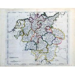
Germany.
Pleasant engraved map of Germany and Poland. Engraved by Neele and published in London in 1808 by Longman & Co.
Place & Date: London, 1808
Selling price: $17
Sold in 2016
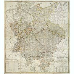
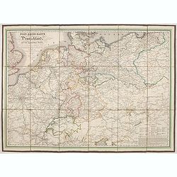
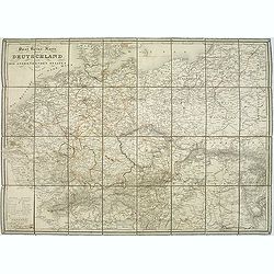
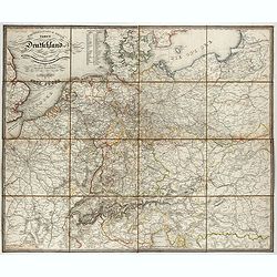
General-Karte von Teutschland in vier Blättern welche als Uebersichts-Tableau der Grosse Charte in 204 Blättern zugleich aber auch als vollständige Post- und orographische Charte dienen kann . . .
Napoleonic folding map of Germany and Italy prepared by Friedrich Wilhelm Streit. Also including Austria, Slovenia, Czech Republic etc.The map has been published during t...
Place & Date: Weimar, 1810
Selling price: $230
Sold in 2013
Germany.
A simple, yet elegant, map of Germany by M. Carey done in the early 19th century.
Place & Date: Philadelphia, 1812
Selling price: $40
Sold in 2010
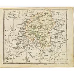
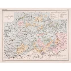
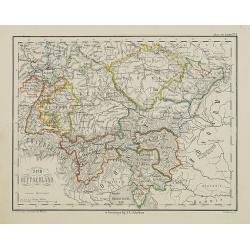
Königreich Wirtemberg.
Nice small map of Wirtemberg in Southern Germany by Johannes Walch in his rare Allgemeiner Atlas Nach den bewährsten Hülfsmitteln und astronomischen Ortsbestimungen…,...
Place & Date: Augsburg, 1812
Selling price: $50
Sold in 2017
Topographische Karte von Deutschland und Italien nebst den angrenzenden Landern. . .
Second edition of this rare Napoleonic folding map of Germany and Italy prepared by Joseph Dirwalt. Also including present-day Poland, part of Austria, Switzerland, and s...
Place & Date: Vienna, 1813
Selling price: $365
Sold in 2013
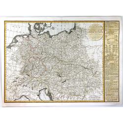
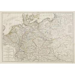
Carte d'Allemagne dressée sur les observations Astronomiques et Géographiques. . .
Uncommon map published by Dezauche after G. de l'Isle however updated according to the Treaty of Paris of 1815, which was signed on 20 November 1815 following the defeat ...
Place & Date: Paris, 1819
Selling price: $50
Sold in 2019
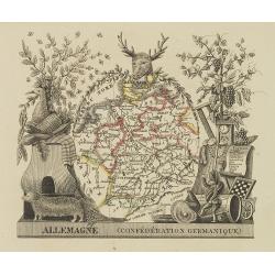
Allemagne (confédération Germanique)
Attractive map of Germany with decorative borders depicting typical artifacts and produce of the continent. Published in Les jeunes voyageurs en Europe.. . Engraved by th...
Place & Date: Brussels, 1824
Selling price: $65
Sold in 2011
Carte de l'Allemagne Contenant les Etats de la Confédération Germanique, le Royaume de Prusse.
A large, finely detailed map of central Europe, showing the Confederation of the Rhine, which was formed in 1806 by a group of Germans, that decided to throw their nation...
Place & Date: Paris, 1825
Selling price: $26
Sold in 2016
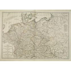
Post-reise-karte von Deutschland und den angränzernden Staaten.
Uncommon post road mapspost route map of Germany, Poland, the Low Countries, Switzerland, Austria and Hungary.
Place & Date: Augsburg, 1826
Selling price: $150
Sold in 2021
Carte d'Allemagne dressee sur les observations astronomiques et geographiques. . .
Uncommon map published by Dezauche after G. de l'Isle however updated according the Treaty of Paris of 1815, who was signed on 20 November 1815 following the defeat and s...
Place & Date: Paris, 1829
Selling price: $100
Sold in 2012
Post Reise Karte durch Deutschlandund die Angraenzenden Staaten. . .
post road maps map of Germany, Poland, the Low Countries, Switzerland and Austria. Folding map dissected in 8 sections, canvas mounted. The map is showing incredible deta...
Place & Date: Vienna, 1830
Selling price: $180
Sold in 2011
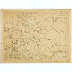
General- Post- und Reis-carte von Deutschland und den Nachbarländern bis Paris... / Carte générale et routière de l'Allemagne et des pays limitrophes jusqu'à Paris...
Road map of Germany and neighboring countries reaching as far as Paris, London, Copenhagen, Warsaw and Boulogne, compiled from official materials and the most recent maps...
Place & Date: Francfurt am Main, Charles Jugel, 1833
Selling price: $150
Sold in 2022
Allemagne centrale.
"Map of Germany.From Malte-Brun's Atlas Géographie Universelle..""., revised by Jean Jacques Nicolas Huot.This very fine executed map has been p...
Place & Date: Paris 1837
Selling price: $5
Sold
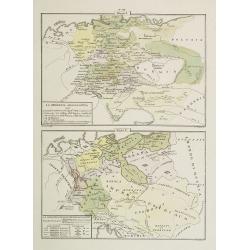
La Germania Legislativa . . . / La Germania ne' suoi principali dominii . . .
Two rare maps of Germany: Top map: 160 x 235mm. Bottom map: 155 x 230mm.Prepared by Las Casas for l'Atlante Storico, Letterario, Biografico, Archeologico. . . with attri...
Place & Date: Venice, 1840
Selling price: $12
Sold in 2022
Kaiserreich Deutschland.
Fine manuscript map of The German Empire, which was the historical German nation state that existed from the unification of Germany in 1871 to the abdication of Kaiser Wi...
Place & Date: Germany, ca. 1843
Selling price: $7
Sold in 2018
Allemagne.
Decorative map of Germany and Poland, prepared by J.G.Barbié du Bocage.Engraved by Ch.Smith, published by Basset who was established in Paris, rue de Seine 33. From atla...
Place & Date: Paris, 1846
Selling price: $20
Sold in 2016
Karta öfver Tyskland.
An very rare map of Germany, Austria, and part of present-day Poland and Czech Republic with Swedish text. This is an updated version of his map of 1819 and is now dated ...
Place & Date: A. Wiborgs förlag, Stockholm, ca. 1848
Selling price: $38
Sold in 2022

Circoscrizione delle province ecclesiastiche Diocesi e missioni nella Germania (Tav LXXVI)
This large-format Germany map is finely engraved and beautifully colored and was prepared by Girolamo Petri, a lawyer who served as a senior official within the Vatican�...
Place & Date: Rome, 1858
Selling price: $120
Sold in 2021
Zuid Duitschland.
Uncommon map of Southern part of Germany. Lithography by J.H. van Weijer, published in Atlas der geheele Aarde [?] in 24 kaarten. Showing railway system.
Place & Date: Groningen, ca. 1860
Selling price: $10
Sold in 2008
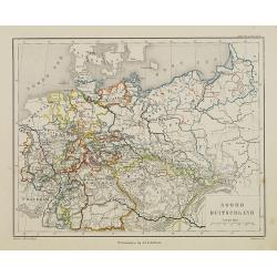
Noord Duitschland.
Uncommon map of the northern part of Germany. Lithography by J.H. van Weijer, published in Atlas der geheele Aarde [?] in 24 kaarten.
Place & Date: Groningen, ca. 1860
Selling price: $10
Sold in 2008
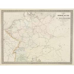
Carte des Chemins de Fer de l'Allemagne.
Fine map of Germany, The Netherlands and Eastern Europe, showing the early railway system of the area. From Atlas des Chemins de Fer published by Napoléon Chaix and pri...
Place & Date: Paris, 1863
Selling price: $2
Sold in 2011
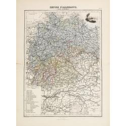
Empire d'Allemange.
Decorative map of the Germany from Géographie Universelle, Atlas Migeon. published by J. Migeon. Engraving by Schroeder of a view of Mayence in the upper right corner.Fr...
Place & Date: Paris 1874
Selling price: $10
Sold
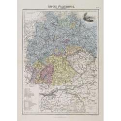
Empire d'Allemagne (Carte d'ensemble).
A decorative map of Germany from Géographie Universelle, Atlas Migeon, published by J. Migeon. With an engraving of Mainz in upper right corner.From one of the last deco...
Place & Date: Paris, 1874
Selling price: $5
Sold in 2018
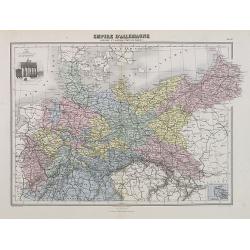
Empire d'Allemagne (Prusse et autres Etats du Nord).
A decorative map of the German Empire with Prussia and other northern States from Géographie Universelle, Atlas Migeon, published by J. Migeon. With an engraving of the ...
Place & Date: Paris, 1874
Selling price: $20
Sold in 2009
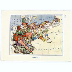
Germany.
A fun and unusual map of Germany, in the shape of the Story of the Pied Piper of Hamelin. Map No.9, in good printed color, shows some cities and towns. Lines of longitude...
Place & Date: London, 1912
Selling price: $75
Sold in 2017
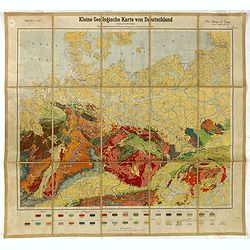
Kleine Geologische Karte von Deutschland. hrsg. von der Preussischen Geologischen Landesanstalt 1930.
Geological map (1:2.000.000) showing Germany and Poland and made by Walter Schriel (1892-1959).Printed by Berliner Lithographisches Institut, Berlin.Provenance : Foundati...
Place & Date: Berlin, c. 1930
Selling price: $50
Sold in 2016
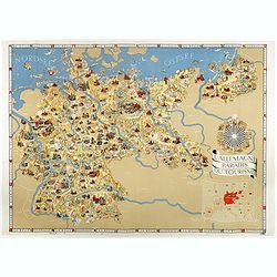
L'Allemagne au paradis du tourisme.
Iconographic map of Germany designed by Walter Riemer, published during pre world war II, by Reichsbahnzentrale. This propaganda paper was published in preparation for th...
Place & Date: Berlin, 1936
Selling price: $410
Sold in 2017
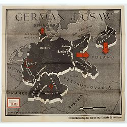
German Jigsaw.
BONUS Map depicting Germany separated into a jigsaw puzzle. "Enlargement of original map drawn for TIME the weekly news magazine" according to note in right han...
Place & Date: New York , Time Magazine, 1944
Selling price: $200
Sold in 2017
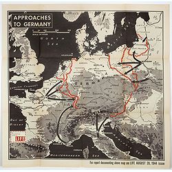
Approaches to Germany.
BONUS Map depicting possible routes into Germany from Russia, France, and Italy. "Enlargement of original map drawn for LIFE" according to note in lower left co...
Place & Date: New York , Time Magazine, 1944
Selling price: $151
Sold in 2018
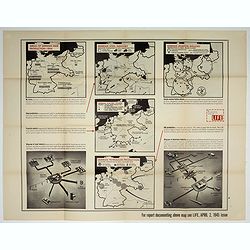
Germany's critical minerals
BONUS Map depicting 5 maps showing German steel, airplane, petroleum, etc. production around 1944. Design by Jerry Muscott (Enlargement reprint for Life Magazine, April 2...
Place & Date: New York , Life Magazine, 1945
Selling price: $210
Sold in 2017
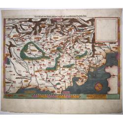
Teutschland,mit seinem gantzen begriff und eingeschlossnen Landschafften.
A fine antique woodcut map of Germany by Sebastian Münster, ca 1550, Basel. From a German edition of his 'Cosmography'.Germany, with parts of the Netherlands, Austria, S...
Place & Date: Basel, ca 1550
Selling price: $170
Sold in 2020
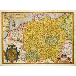
Germania. . .
A map of Germany from Abraham Ortelius’ "Theatrum Orbis Terrarum" is probably based on the map by Christaan Sgrooten. Embellished with a large title-cartouche...
Place & Date: Antwerp, 1571.
Selling price: $200
Sold in 2021
Cercle de Bavière, suivant les nouvelles observations..
With decorative title cartouche upper right corner.This example is unusual in having the additional separately engraved decorative framework border around the map, the re...
Place & Date: Amsterdam 1728.
Selling price: $90
Sold
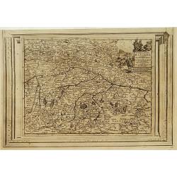
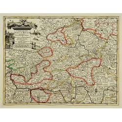
Partie Septentrionale du Cercle d'Autriche...
Map showing the postal routes in The Netherlands, Belgium, France, Poland, Austria, Switzerland and Northern Italy. With an ornamental cartouche.
Place & Date: Paris, 1752.
Selling price: $104
Sold
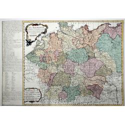
La ALEMANIA dividida en sus principales Estados segun las ultimas y nuevas observationes de las Accademias y de Paris y de Londres.
A beautiful, rare colored map of Germany by the Spanish cartographer Pedro Gendron. As in most 18th century maps published in Spain, which are based upon non-Spanish sour...
Place & Date: Madrid(?), ca 1760
Selling price: $150
Sold in 2020
Lot of 3 maps of Germany.
Robert de Vaugondy: Empire d'Allemagne, 24 cm x 28 cm. Van der AA : Cercle du Haut Rhin, 22,5cm x 29 cm: L'Allemagne, 22,5 cm x 29 cm.The three maps are well-engraved.
Place & Date: Paris/ Leiden
Selling price: $40
Sold