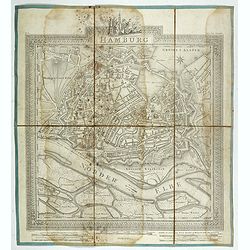
Hamburg.
Plan of the city of Hamburg, drawn up and published by C.L.B. Mirbeck in London, engraved by B. Baker.
Place & Date: London, 1803
Selling price: $36
Sold in 2022
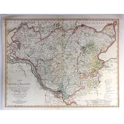
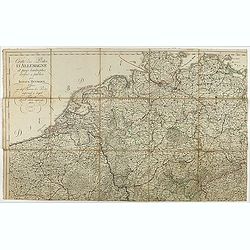
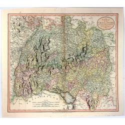
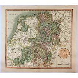
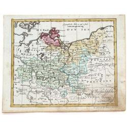
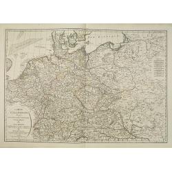
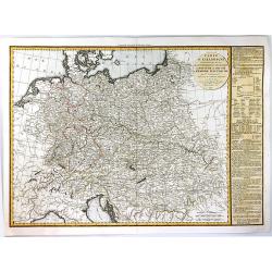
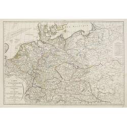
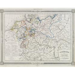
A Map of the Dutchy of Holstein with the Territories of the Imperial Towns Hamburg and Lübek, Also the Bishoprick of Eutin...
A Map of the Dutchy of Holstein with the Territories of the Imperial Towns Hamburg and Lübek also the Bishoprick of Eutin…A pleasing map of the Duchy of Holstein, with...
Place & Date: London, 1804
Selling price: $35
Sold in 2016
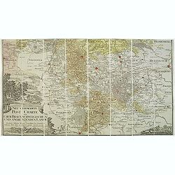
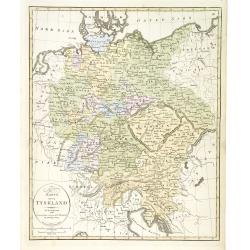
Neu vermehrte post charte der chur Braunschweigischen und angrenzenden lande. . . Von Friedrich Wilhelm Ohsen, ... privatim entworfen im Jahre 1774, verbessert 1805.
Unfortunately only the lower half of a post road maps map of North-Western Germany, centered on Braunsschweig.Prepared by Friederich Wilhelm Ohsen in 1774 and updated for...
Place & Date: Hannover, 1774 - 1805
Selling price: $50
Sold in 2018
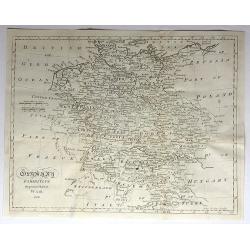
Germany Exhibiting the Present Seat of War, 1805.
A detailed map of Europe, highlighting the position of the war in and around Germany as at 1805. It covers and area from Denmark in the north Turkey in the south, from Fr...
Place & Date: Germany, 1805
Selling price: $69
Sold in 2017

Entrée des Français à Berlin, le 27 Octobre 1806.
Engraving representing Napoleon and his troops in front of the Brandenburg Door.
Place & Date: Paris, ca. 1806
Selling price: $100
Sold in 2008
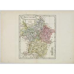
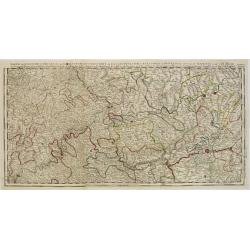
Haut et Bas Rhin Franconie Souabe.
Map of High and Low Rhine Franconie Souabe. By Robert de Vaugondy, Geographer.
Place & Date: Paris, 1794 - 1806
Selling price: $5
Sold in 2022
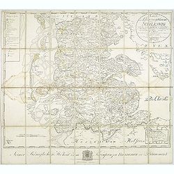
Karte vom Herzogthum Schleswig, nach der von der Gesellschaft der Wissenschaften in Kopenhagen bekannt gewordenen Ortsbestimmung und nach Special-Karten. Kolor. Kupferstichkarte von F. v. Golowin. Schleswig, Röhss u. Christiani, 1806.
Von Golowin was a Lieutenant in the "Schleswigschen Infanterie-Regiment" and appointed cartographer to the King. The first edition of this road map was publishe...
Place & Date: Schleswig, Röhfs und Christiani, 1806
Selling price: $175
Sold in 2010
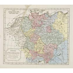
Empire d'Allemagne. . .
Map of the German Empire. By C. F. Delamarche, successor of Robert de Vaugondy, Geographer.
Place & Date: Paris, 1794 – 1806
Selling price: $3
Sold in 2022
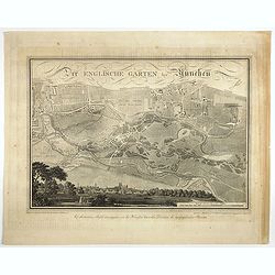
Der Englische Garten Bey München.
A northwest oriented plan of Der Englische Garten ( the English Garden) drawn by von Rickhauer in 1806 and engraved by J. Carl Schleich.The title in decorative lettering ...
Place & Date: Topogr. Bureau, Munich 1806
Selling price: $500
Sold in 2017
Cartes des Postes d'Allemagne et pays limitrophes. . .
Upper left part of a large detailed post road mapspost route map of Germany. Centered on Bielefeld and showing the cities of Hamburg, Coblenz. And Belgium, The Netherland...
Place & Date: Trieste, 1806
Selling price: $55
Sold in 2018

Home & Femme de la Foret noire.
Originally hand-colored mezzotint from 'Costumes civils actuels de tous les peuples connus'. Engraved by Lachaussée Jeune after Jacques Grasset de Saint-Sauveur.As an et...
Place & Date: Paris,1806
Selling price: $30
Sold in 2017

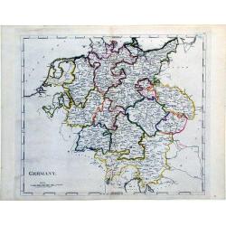
Germany.
Pleasant engraved map of Germany and Poland. Engraved by Neele and published in London in 1808 by Longman & Co.
Place & Date: London, 1808
Selling price: $17
Sold in 2016
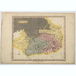
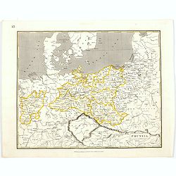
Prussia.
An attractive map with full original color from Wilkinson's General Atlas of the World, Quarters, Empires, Kingdoms, States &c. with Appropriate Tables published by R...
Place & Date: London, 1808
Selling price: $1
Sold in 2021
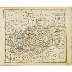
Das Sconigr. Sachsen mit den Kurfurstlich und Herzoglich Saechsischen Laendern. . .
Detailed map of the region of eastern Germany published by the Nuremberg firm Schneider and Weigel in 1809. Shows the cities of Berlin (at the north), Dresden, Leipzig an...
Place & Date: Nuremberg, 1809
Selling price: $70
Sold in 2010
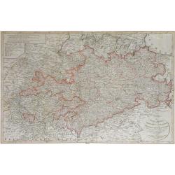
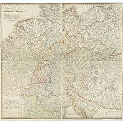
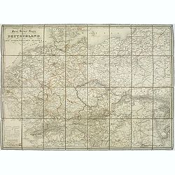
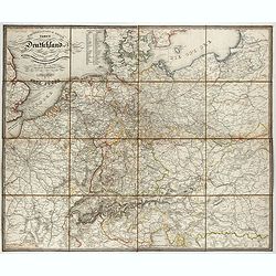
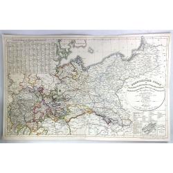
General-Karte von Teutschland in vier Blättern welche als Uebersichts-Tableau der Grosse Charte in 204 Blättern zugleich aber auch als vollständige Post- und orographische Charte dienen kann . . .
Napoleonic folding map of Germany and Italy prepared by Friedrich Wilhelm Streit. Also including Austria, Slovenia, Czech Republic etc.The map has been published during t...
Place & Date: Weimar, 1810
Selling price: $230
Sold in 2013
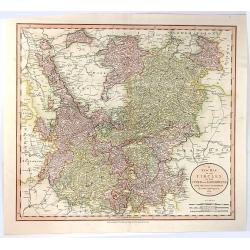
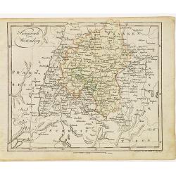
A New Map of the Circle of Swabia, from the Latest Authorities
A fine map of the Swabia region of Germany. Map covers from the Upper Rhine region south as far as Switzerland. Extends eastward as far as Bavaria and westward as far as ...
Place & Date: London, 1811
Selling price: $20
Sold in 2016
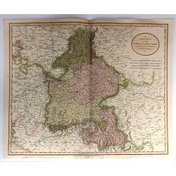
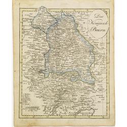
A New Map of the Circle of Bavaria, From the Latest Authorities . . .
A detailed map of John Cary’s Bavaria, from the important early 19th century “NEW UNIVERSAL ATLAS”. The map covers the entire circle of Bavaria. Ronald Vere Tooley...
Place & Date: Paris, 1811
Selling price: $43
Sold in 2017
A New Map of the Circles of the Upper and Lower Rhine, from the Latest Authorities
A fine map of the Rhine region of Germany. Map covers from the Westphalia region south as far as France. Extends eastward as far as Luxemburg, and westward as far as Fran...
Place & Date: London, 1811
Selling price: $16
Sold in 2016
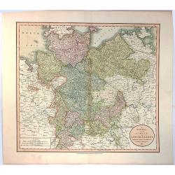
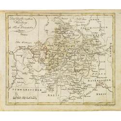
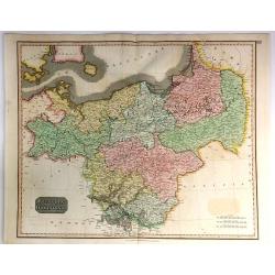
A New Map of the Circle of Lower Saxony, from the Latest Authorities.
A fine map of the Lower Saxony region of Germany. Map covers from the Holstein region south as far as Lower Rhine. Extends eastward as far as Westphalia and westward as ...
Place & Date: London, 1811
Selling price: $27
Sold in 2016
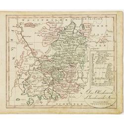
A New Map of the Circle of Westphalia From the Latest Authorities.
An attractive example of John Cary's 1811 map of the Westphalia region of Germany. Map covers from the North Sea to the Lower Rhine, it also includes much of Holland, Bel...
Place & Date: London, 1811
Selling price: $46
Sold in 2017
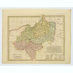
Prussia.
A general map of Prussia, engraved by J.Wallis for Oddy's General Atlas in full original color. Prussia was a historically prominent German state that originated in 1525 ...
Place & Date: London, 1811
Selling price: $15
Sold in 2021
Germany.
A simple, yet elegant, map of Germany by M. Carey done in the early 19th century.
Place & Date: Philadelphia, 1812
Selling price: $40
Sold in 2010
Sachsen.
Nice small map of Saxe in Germany by Johannes Walch in his rare Allgemeiner Atlas Nach den bewährsten Hülfsmitteln und astronomischen Ortsbestimungen…, edition of 181...
Place & Date: Augsburg, 1812
Selling price: $20
Sold in 2017
Das Grossherzogthum Würzburg, und die Fûrst Primatischen Staaten.
Nice small map of Wurzburg in Southern Germany by Johannes Walch in his rare Allgemeiner Atlas Nach den bewährsten Hülfsmitteln und astronomischen Ortsbestimungen…, e...
Place & Date: Augsburg, 1812
Selling price: $50
Sold in 2018
Der Oberrheinische u. Churrheinische Kreis.
Nice small map centered on Frankfurt in Eastern part of Germany by Johannes Walch in his rare Allgemeiner Atlas Nach den bewährsten Hülfsmitteln und astronomischen Orts...
Place & Date: Augsburg, 1812
Selling price: $25
Sold in 2020
Das Königreich Baiern.
Nice small map of Bayern in Southern Germany by Johannes Walch in his rare Allgemeiner Atlas Nach den bewährsten Hülfsmitteln und astronomischen Ortsbestimungen…, edi...
Place & Date: Augsburg, 1812
Selling price: $45
Sold in 2015
Königreich Wirtemberg.
Nice small map of Wirtemberg in Southern Germany by Johannes Walch in his rare Allgemeiner Atlas Nach den bewährsten Hülfsmitteln und astronomischen Ortsbestimungen…,...
Place & Date: Augsburg, 1812
Selling price: $50
Sold in 2017
Obersachsischer Kreis Nordlicher Theil. (Brandenberg & Pommern)
Infomative little map of Brandenberg and Pommern. By Johann Walsh (1757 - 1824) from the 1812 edition of his atlas, "ALLGEMEINER ATLAS NACH DEN BEWAHSTEN".
Place & Date: Augsburg, 1812
Selling price: $11
Sold in 2016
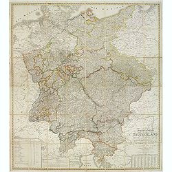
Topographische Karte von Deutschland und Italien nebst den angrenzenden Landern. . .
Second edition of this rare Napoleonic folding map of Germany and Italy prepared by Joseph Dirwalt. Also including present-day Poland, part of Austria, Switzerland, and s...
Place & Date: Vienna, 1813
Selling price: $365
Sold in 2013

Bataille de Vurtchen Remportée par les Français, sous les ordres de Napoléon I.er sur les Armées de Prusse et de Russie, combinées le 20 Mai 1813.
Print published in "Paris chez Jean Rue Saint Jean de Beauvais N° 10". Showing the battle of Würschen won by Napoléon over the Prussian/Russian army.Read mor...
Place & Date: Paris, Jean, ca 1813
Selling price: $40
Sold in 2016
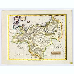
Prussia.
A small, early nineteenth-century map of Prussia. The cities of Berlin, Dantzick and Konigsberg are highlighted in red. Map extent is from Magdeburg in the west to Poznan...
Place & Date: Liverpool, ca 1814
Selling price: $2
Sold in 2021
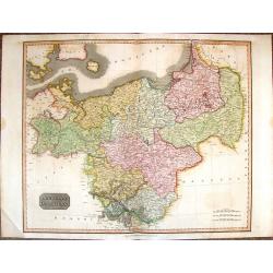
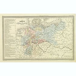
Prussian Dominions.
A vivid hand colored 1815 Thomson map of Prussia or Northern and Central Europe. It comes from Thomson's "NEW GENERAL ATLAS".
Place & Date: Edinburgh, 1815
Selling price: $45
Sold in 2017
Prussian Dominions
An excellent hand colored 1815 map by the cartographer John Thomson. It depicts Prussia (central and northern Europe). The Map covers from the Baltic Sea to Upper Silesia...
Place & Date: Edinburgh, 1815
Selling price: $37
Sold in 2018
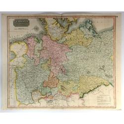
Germany, North of the Mayne.
A fine hand colored 1816 map depicting the semi-autonomous kingdoms, duchies, and Prussian territories of northern Germany. These include: Westphalia, Rhineland, Saxony, ...
Place & Date: Edinburgh, 1816
Selling price: $47
Sold in 2018
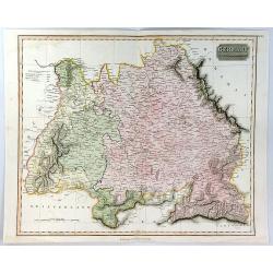
Germany South of the Maine.
A fine map of southern Germany published in Edinburgh in 1817 in Thomson's “New General Atlas”.It is an interesting large format copper engraved antique map of the ea...
Place & Date: Edinbourgh, 1817
Selling price: $117
Sold in 2020
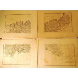
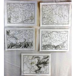
La Bassa Germania (4 Maps)
Four rare maps from "Atlante Geografico" by the priest Bartolomeo Borghi. This was considered as the most important Florentine atlas. The four maps are hand mar...
Place & Date: Florence, 1818
Selling price: $1
Sold in 2015
Carte d'Allemagne dressée sur les observations Astronomiques et Géographiques. . .
Uncommon map published by Dezauche after G. de l'Isle however updated according to the Treaty of Paris of 1815, which was signed on 20 November 1815 following the defeat ...
Place & Date: Paris, 1819
Selling price: $50
Sold in 2019
Prussia.
An early nineteenth century map of Prussia, published in Edinburgh. It also shows the southern tip of Sweden, Denmark, and extends as far south as the Carpathian Mountain...
Place & Date: Edinburgh, 1820
Selling price: $20
Sold in 2021
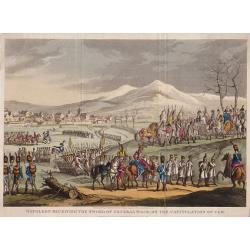
Napoleon Receiving The Sword of General Mack, on the Capitulation of Ulm.
An interesting historical engraving. Engraved by George Cruikshank from the original design of C. Vernet, executed at Paris by I. Duplessi Bertaux.Published on December 2...
Place & Date: London, 1823
Selling price: $80
Sold in 2019
Partie des Estats Des Cercles des quatre Electeurs et Du Haut Rhin ou sont L'Archevesché et Electorat de Treves..
Detailed map of Rhineland-Palatinate and part of the contiguous regions.Towns highlighted in red. Showing Trier, Bonn, Koblenz, Frankfurt and Mainz.Prepared by Henry Seng...
Place & Date: Paris 1824
Selling price: $50
Sold
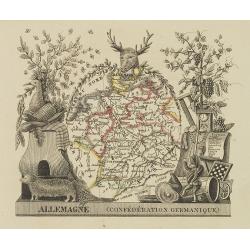
Allemagne (confédération Germanique)
Attractive map of Germany with decorative borders depicting typical artifacts and produce of the continent. Published in Les jeunes voyageurs en Europe.. . Engraved by th...
Place & Date: Brussels, 1824
Selling price: $65
Sold in 2011
Carte Generale du Royaume de Prusse. . .
A nice French map, typical of the period, of the Kingdom of Prussia, by Vivien, from the "Atlas Universel Pour servir a l'Etude De la Geographie et de l'Histoire Anc...
Place & Date: Paris, 1824
Selling price: $12
Sold in 2021

Combat et prise de Ratisbonne.
Print published in "Paris chez la Ve. Chéreau M.de d'estampes, rue St. Jacques N°10, aux deux Colonnes, près la Fontaine St. Séverin". The text below the pr...
Place & Date: Paris, Vve Chéreau, before 1825
Selling price: $20
Sold in 2016
Carte de l'Allemagne Contenant les Etats de la Confédération Germanique, le Royaume de Prusse.
A large, finely detailed map of central Europe, showing the Confederation of the Rhine, which was formed in 1806 by a group of Germans, that decided to throw their nation...
Place & Date: Paris, 1825
Selling price: $26
Sold in 2016
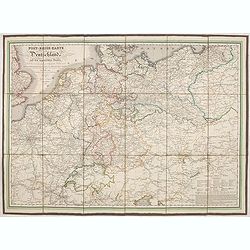
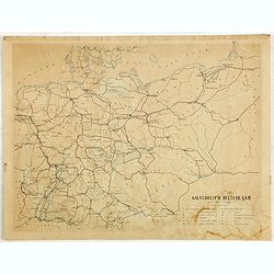
Post-reise-karte von Deutschland und den angränzernden Staaten.
Uncommon post road mapspost route map of Germany, Poland, the Low Countries, Switzerland, Austria and Hungary.
Place & Date: Augsburg, 1826
Selling price: $150
Sold in 2021
(5 Maps) from “Precis des Evenemens Militares”
A collection of five out a total of 117 specific military events and plans to serve the intelligence of military operations described in the text. These maps are numbered...
Place & Date: Paris, ca 1826
Selling price: $15
Sold in 2016
Carte d'Allemagne dressee sur les observations astronomiques et geographiques. . .
Uncommon map published by Dezauche after G. de l'Isle however updated according the Treaty of Paris of 1815, who was signed on 20 November 1815 following the defeat and s...
Place & Date: Paris, 1829
Selling price: $100
Sold in 2012
Post Reise Karte durch Deutschlandund die Angraenzenden Staaten. . .
post road maps map of Germany, Poland, the Low Countries, Switzerland and Austria. Folding map dissected in 8 sections, canvas mounted. The map is showing incredible deta...
Place & Date: Vienna, 1830
Selling price: $180
Sold in 2011
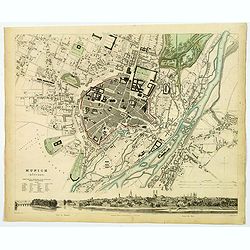
Munich (Munchen).
This is a beautiful first edition map of the German city of Munich, issued in 1832 by the Society for the Diffusion of Useful Knowledge, or S.D.U.K. It depicts the city a...
Place & Date: London, 1832
Selling price: $35
Sold in 2020
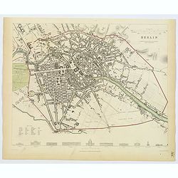
Berlin.
This delightful plan of Berlin has architectural elevations of principal public buildings at its foot. Berlin was capital of the Kingdom of Prussia, Austria’s rival as ...
Place & Date: London, 1833
Selling price: $50
Sold in 2019
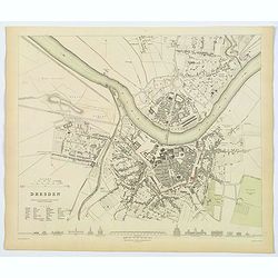
Dresden.
This delightful plan of Dresden, the capital city of the German region of Saxony. It has architectural elevations of principal public buildings at its foot. This plan sho...
Place & Date: London, 1833
Selling price: $40
Sold in 2020
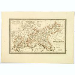
General- Post- und Reis-carte von Deutschland und den Nachbarländern bis Paris... / Carte générale et routière de l'Allemagne et des pays limitrophes jusqu'à Paris...
Road map of Germany and neighboring countries reaching as far as Paris, London, Copenhagen, Warsaw and Boulogne, compiled from official materials and the most recent maps...
Place & Date: Francfurt am Main, Charles Jugel, 1833
Selling price: $150
Sold in 2022
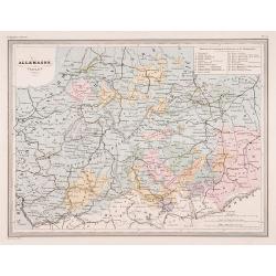
Allemagne centrale.
"Map of Germany.From Malte-Brun's Atlas Géographie Universelle..""., revised by Jean Jacques Nicolas Huot.This very fine executed map has been p...
Place & Date: Paris 1837
Selling price: $5
Sold
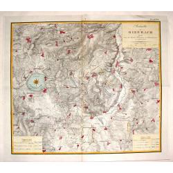
Batailles de Biberach Livrees Entre les Armees Francaises et Autricheinnes en 1796 et 1800.
Fine military map depicting the details of the battlefield of Biberach. It features fortifications and troop placements. Three plain block cartouches and unique compass r...
Place & Date: Paris, 1839
Selling price: $10
Sold in 2015
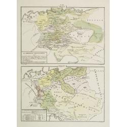
La Germania Legislativa . . . / La Germania ne' suoi principali dominii . . .
Two rare maps of Germany: Top map: 160 x 235mm. Bottom map: 155 x 230mm.Prepared by Las Casas for l'Atlante Storico, Letterario, Biografico, Archeologico. . . with attri...
Place & Date: Venice, 1840
Selling price: $12
Sold in 2022
Prusse et confédération Germanique.
Finely engraved map of Prussia and part of Poland prepared by A.H.Dufour and engraved by Giraldon-Bovinet. Published by Jules Renouard in his uncommon atlas "Le glob...
Place & Date: Paris, Jules Renouard, ca.1840
Selling price: $40
Sold in 2011
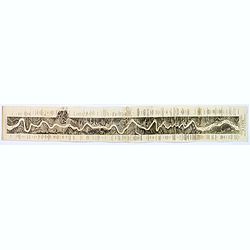
Panoramic Map of the Rhine from Cologne to Meyence.
A lovely long panoramabird's eye viewshowing the route from Cologne to Meyence, engraved to accompany Tombleson's view books on the Upper Rhine. Panorama is flanked on ei...
Place & Date: London, ca. 1840
Selling price: $45
Sold in 2018
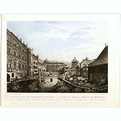
Südlicher theil des Heidelberg schlosses . . . Façade du midi du château de Heidelberg . . .
Early aquatint after Louis Charles François de Graimberg-Belleau. Lithographed by Hibon and Paul Legrand.French artist. Son of Gilles-François Belleau Graimberg. Louis ...
Place & Date: Graimberg, Heidelberg, ca. 1840
Selling price: $65
Sold in 2018
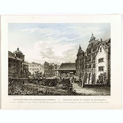
Westlicher theil des Heidelberg schlosses . . . Façade de l'ouest du château de Heidelberg . . .
Earlyaquatint after Louis Charles François de Graimberg-Belleau. Lithographed by Hibon and Paul Legrand.French artist. Son of Gilles-François Belleau Graimberg. Louis C...
Place & Date: Graimberg, Heidelberg, ca. 1840
Selling price: $65
Sold in 2018
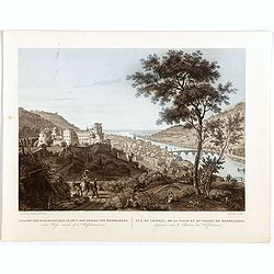
Ansicht des schlosses, der stradt u. des thales von Heidelberg . . . Vue du château, de la ville et du vallon de Heidelberg . . .
Early aquatint after Louis Charles François de Graimberg-Belleau. Lithographed by Salathé.French artist. Son of Gilles-François Belleau Graimberg. Louis Charles Franç...
Place & Date: Graimberg, Heidelberg, ca. 1840
Selling price: $100
Sold in 2018
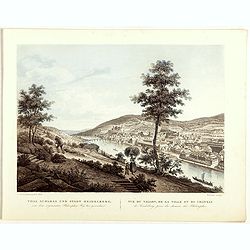
Thal schloss und stadt Heidelberg . . . Vue du vallon, de la ville et du château de Heidelberg . . .
Early lithographs after Louis Charles François de Graimberg-Belleau. Lithographed by Salathé.French artist. Son of Gilles-François Belleau Graimberg. Louis Charles Fra...
Place & Date: Graimberg, Heidelberg, ca. 1840
Selling price: $60
Sold in 2018
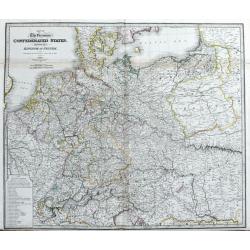
Map of the Germanic Confederated States, including the Kingdom of Prussia, as Settled by the Act of Congress at Vienna, June 9th 1815.
Large and detailed map of central Europe. From France until Poland, Russia, Lithuania and Hungary. And from Denmark until Venice and Belgrade. With areas, roads, rivers, ...
Place & Date: London, c1840
Selling price: $30
Sold in 2020
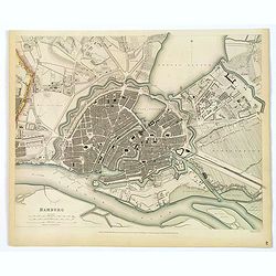
Hamburg.
An appealing plan of the important northern German port city of Hamburg. It is a nice detailed central town plan including its many canals, streets, buildings, and other ...
Place & Date: London, 1841
Selling price: $50
Sold in 2019
Kaiserreich Deutschland.
Fine manuscript map of The German Empire, which was the historical German nation state that existed from the unification of Germany in 1871 to the abdication of Kaiser Wi...
Place & Date: Germany, ca. 1843
Selling price: $7
Sold in 2018
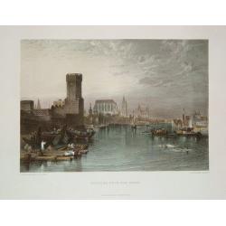
Cologne from the River.
An uncommon, nicely defined steel-plate view of Cologne as seen in the early-to-mid 1800s. The city's famous cathedral is shown. The river scene includes commercial barge...
Place & Date: New York, ca. 1845
Selling price: $30
Sold in 2011
Allemagne.
Decorative map of Germany and Poland, prepared by J.G.Barbié du Bocage.Engraved by Ch.Smith, published by Basset who was established in Paris, rue de Seine 33. From atla...
Place & Date: Paris, 1846
Selling price: $20
Sold in 2016
Der Preussische Staat
A fine detailed map of Prussia by Dr. F.W. Streit. Published in Leipzig in 1847. It was produced on two sheets that have been conjoined.
Place & Date: Leipzig, 1847
Selling price: $33
Sold in 2016
Karta öfver Tyskland.
An very rare map of Germany, Austria, and part of present-day Poland and Czech Republic with Swedish text. This is an updated version of his map of 1819 and is now dated ...
Place & Date: A. Wiborgs förlag, Stockholm, ca. 1848
Selling price: $38
Sold in 2022
Prussia.
A nice example of this marvelous map of Prussia, surrounded by five decorative vignettes. They include the French Church in Berlin, Frederick the Great, The Royal Palace,...
Place & Date: London, 1851
Selling price: $30
Sold in 2019
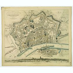
Frankfort.
A detailed plan of the German city of Frankfort, published by the Society for the Diffusion of Useful Knowledge. Streets and prominent buildings shown in great detail, to...
Place & Date: London, 1853
Selling price: $30
Sold in 2020

Birds Eye View of Berlin in 1858.
An interesting woodblock print of Berlin, dated February 20th, 1858. Published February 20th 1858 in the Illustrated London News.This large bird's eye view of Berlin was ...
Place & Date: London, 1858
Selling price: $45
Sold in 2018
Provincia ecclesiastica di Frigurgo nell' Alemagna (Tav LXXIX)
A large-format map south eastern Germany with Fribourg and its different dioceses. The map is finely engraved and beautifully colored and was prepared by Girolamo Petri, ...
Place & Date: Rome, 1858
Selling price: $150
Sold in 2021
Provincia ecclesiastica di Colonia nella Prussia (Tav LXXX)
A large-format map of west Germany and Cologne with its different dioceses. The map is finely engraved and beautifully colored and was prepared by Girolamo Petri, a lawye...
Place & Date: Rome, 1858
Selling price: $110
Sold in 2019

Circoscrizione delle province ecclesiastiche Diocesi e missioni nella Germania (Tav LXXVI)
This large-format Germany map is finely engraved and beautifully colored and was prepared by Girolamo Petri, a lawyer who served as a senior official within the Vatican�...
Place & Date: Rome, 1858
Selling price: $120
Sold in 2021
Provincia ecclesiastica di Bamberga nel regno di Baviera (Tav LXXVIII)
This large-format Bamberg map is finely engraved and beautifully colored and was prepared by Girolamo Petri, a lawyer who served as a senior official within the Vatican�...
Place & Date: Rome, 1858
Selling price: $100
Sold in 2020

Château de Heidelberg.
Uncommon and decorative lithography published by Carl Johan Billmark and printed by Lemercier in Paris, 55 rue de Seine, the leading firm in Europe at that time. From: It...
Place & Date: Paris, c.1859
Selling price: $80
Sold in 2015

Hôtel de ville de Lübeck.
Uncommon and decorative lithography of the townhall of Lübeck, published by Carl Johan Billmark and printed by Lemercier in Paris, 55 rue de Seine, the leading firm in E...
Place & Date: Paris, c.1859
Selling price: $135
Sold
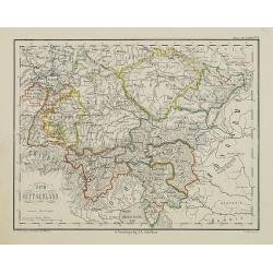
Zuid Duitschland.
Uncommon map of Southern part of Germany. Lithography by J.H. van Weijer, published in Atlas der geheele Aarde [?] in 24 kaarten. Showing railway system.
Place & Date: Groningen, ca. 1860
Selling price: $10
Sold in 2008
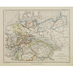
Noord Duitschland.
Uncommon map of the northern part of Germany. Lithography by J.H. van Weijer, published in Atlas der geheele Aarde [?] in 24 kaarten.
Place & Date: Groningen, ca. 1860
Selling price: $10
Sold in 2008

Fontaine Elise a Aix la Chapelle.
Beautiful lithography of a square in Aachen, Germany. Printed by Masson in Brussels and lithographed by F.Stroobant.
Place & Date: Amsterdam, F.Buffa, c. 1860
Selling price: $50
Sold in 2013