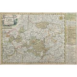
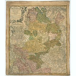
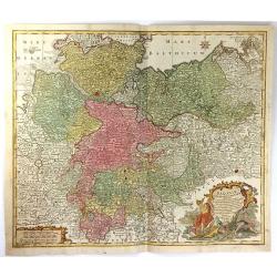
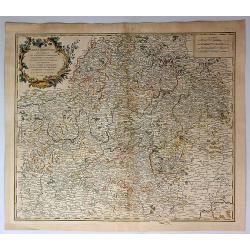
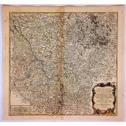
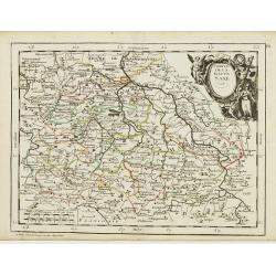
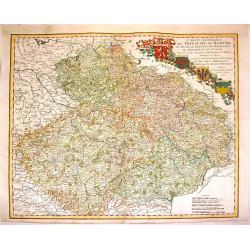
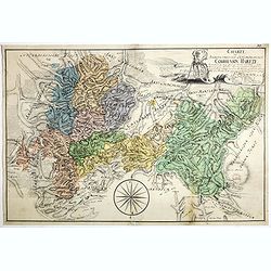
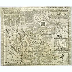
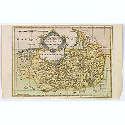
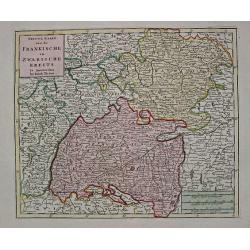
Der Fraenckishe Creis.
Der Fraenckishe Creis by Johann George Schreiber. The map is high in detail the cartouche is surrounded by two cherubs. From Schreiber's "Atlas Selectus". E...
Place & Date: Leipzig, 1749
Selling price: $95
Sold in 2014
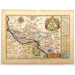
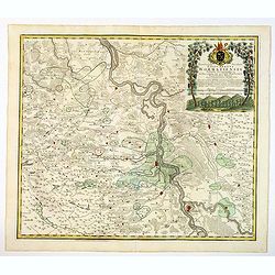
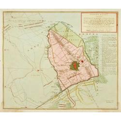
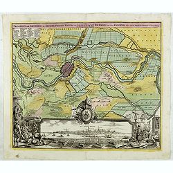
Das Aml Gommern und Die Graffschassl Barby Zu Fiden Bey.
Striking detailed map of Gommern and the Elbe River in Germany. It has two fancy cartuches, one with two children playing, and a interesting detailed compass rose. The to...
Place & Date: Leipsig, 1749
Selling price: $30
Sold in 2015
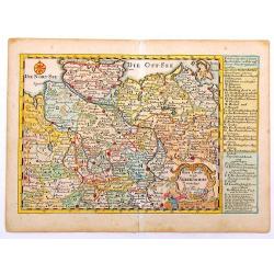
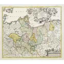
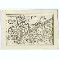
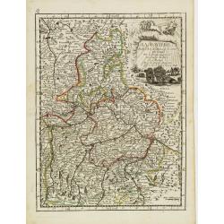
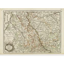
Reise Charte Durch Nieder Sachen
Nicely detailed map of Lower Saxony from "Atlas Selectus". On the right are explanations of political situations. Johann Georg Schreiber (1676 – 1745), a Ger...
Place & Date: Leipzig, 1749
Selling price: $25
Sold in 2014
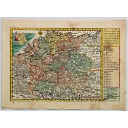
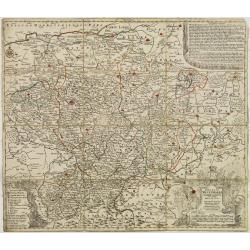
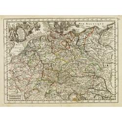
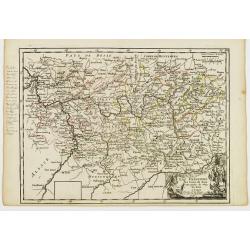
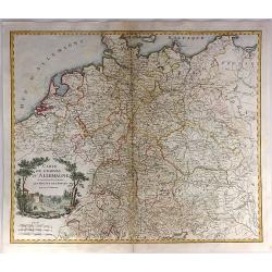
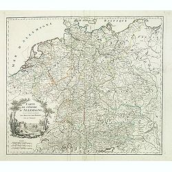
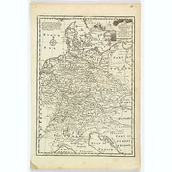
Reise Charte Durch Deutschland.
A pleasing map of Germany by George Schriebern, published in the 'Atlas Selectus' with explanatory text and directory on the right of map With decorative title cartouche ...
Place & Date: Leipzeg, 1749
Selling price: $17
Sold in 2018
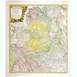
Circuli Westphaliae. . .
Johann Baptist Homann's well-engraved map has a large decorative cartouche. Detailed map of the south-western part of Poland covering the towns of Legnica, Wroclaw, Opole...
Place & Date: Nuremberg 1749
Selling price: $30
Sold in 2022
Ducatus Westphalia novâ mappâ Geographicâ..
Map centered on eastern Germany.
Place & Date: Augsburg 1750
Selling price: $40
Sold
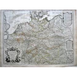
Marchionatus Brandenburgensis Ducatus Pomeraniae et Ducatus Mecklenburgicus..
Seutter's well-engraved map has a large decorative cartouche. Including the towns of Wismar, Stettin, Berlin, etc.
Place & Date: Nuremberg, 1750
Selling price: $250
Sold in 2008
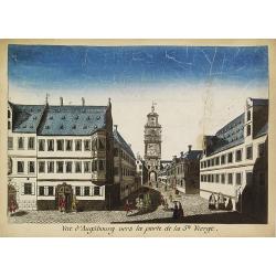
Vue d'Augsbourg vers la porte de la St. Vierge.
Showing a lively scene in 18th century Augsburg. J. Chereau was a publisher of optical prints, established in Paris, rue St.Jacques.In the eighteenth and nineteenth centu...
Place & Date: Paris, ca. 1750
Selling price: $75
Sold in 2015
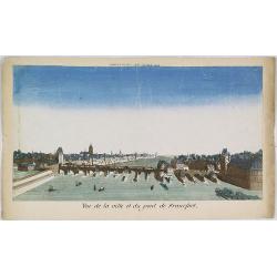
Vue de la ville et du pont de Francfort.
Showing the Medieval bridge over the river Main at Frankfurt am Main. J. Chereau was a publisher of optical prints, established in Paris, rue St.Jacques.In the eighteenth...
Place & Date: Paris, ca. 1750
Selling price: $100
Sold in 2010
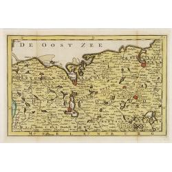
Hertogdom Meklenburg aan de Oostzee.
Uncommon and detailed map of Mecklenburg, including the towns of Rostock, Wismar Swerin and Gustrow. Included in "Zak en reis Atlas van Duitsland". Engraved by ...
Place & Date: Amsterdam, N.T. Gravius, 1750
Selling price: $120
Sold in 2017
Route des postes et des voitures. . .
Road map of Germnany.
Place & Date: Amsterdam, c. 1725-1750
Selling price: $60
Sold in 2010
Tabulae principatus Brandenburgico culmbacensis sive baruthini. . .
Decorative map of Upper Franconia. The map was prepared by J. A. Riediger. From Graefental to Lauf, from Eger to Lichtenfels. Very decorative title cartouche with allegor...
Place & Date: Nuremberg, 1750
Selling price: $75
Sold in 2023
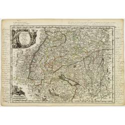
![[No tittle] Folding map centered on the Bodensee, Zurichersee](/uploads/cache/30634-250x250.jpg)
[No tittle] Folding map centered on the Bodensee, Zurichersee
Beautiful and detailed map of the area around the Bodensee, including Konstanz, Liechtenstein, Zurich and Fussen in the east, etc More about folding maps. [+]
Place & Date: Germany, ca. 1750
Selling price: $120
Sold in 2013
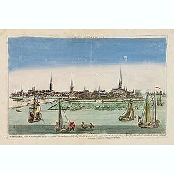
Hambourg, ville d'Allemagne dans le duché de Holstein. . .
Showing the town of Hamburg seen from the river Elbe. Optical print published by Mondhare, who was a well-known publisher of optical prints, established in rue St. Jacque...
Place & Date: Paris, ca. 1750
Selling price: $230
Sold in 2015
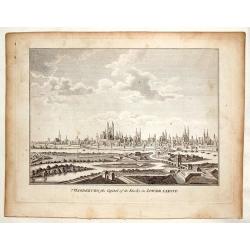
Magdenburg, the Capital of its Duchy in Lower Saxony.
This is a fine copper engraved view of Magdenburg featuring 19 churches with spires, several fortifications and a river system with 10 ships and boats.
Place & Date: Nuremberg, c. 1750
Selling price: $12
Sold in 2016
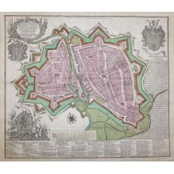
ACCURATA ET NOVISFIMA REPRAEFENTATIO ICHNOGRAPHIEA HANNOVERAE.
Double-page engraved plan of Hanover by Tobias Conrad Lotter.Showing all the churches and notable places, with an inset decorative shield in the top right with details ab...
Place & Date: Augsburg, 1750
Selling price: $650
Sold in 2014
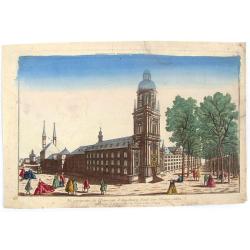
Vue Perspective de L'Universite d'Augsbourg Fonde par L'Eveque Julien.
Original antique print published by Chereau in Paris in c1750. This is an optical print, also called “Vue Optique” or “Vue d'Optique”, which were made to be viewe...
Place & Date: Paris, c1750
Selling price: $16
Sold in 2019
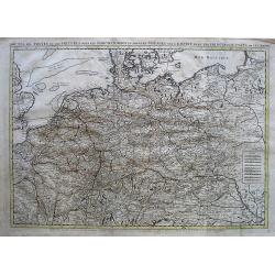
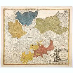
Saxoniae Inferioris circulus, exhibens ducatus Brunswic
This large detailed map of Saxony shows northern Germany with Sachsen Anhalt, Niedersachsen, Mecklenburg Vorpommern, Schleswig, Holstein, Brandenburg, Hamburg, Bremen and...
Place & Date: Augberg, 1750
Selling price: $30
Sold in 2016
Antient Germany.
A map of Germany in Roman times, that also shows Denmark and southern tip of Sweden, and parts of eastern Europe. With good map detail, including rivers, regions, towns, ...
Place & Date: London, ca 1750
Selling price: $20
Sold in 2019
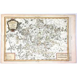
Cercle de Westphalie, divisé en tous ses etats et souverainetés.
Detailed map of the northwestern part of Germany, centered on M¨nster.
Place & Date: Paris, 1751
Selling price: $10
Sold in 2014
Partie méridionale du cercle de Haute Saxe. . .
Detailed map of part of Germany, centered on Leipzig.
Place & Date: Paris, 1751
Selling price: $10
Sold in 2014
Partie méridionale du cercle de Haute Saxe. . .
Highly detailed regional map from De Vaugondy's Atlas Universel.
Place & Date: Paris, 1751
Selling price: $10
Sold in 2014
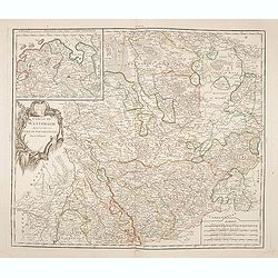
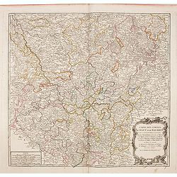
Le cercle de Baviere . . .
Interesting regional map, extending from Waldeck in the North to Efferding on the Danube in the East, Saltzberg and the Tyrolian Alps in the South and Dillingen on the Da...
Place & Date: Paris, 1751
Selling price: $10
Sold in 2016
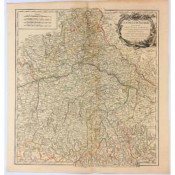
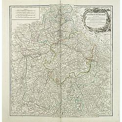
Le Cercle de Baviere Qui Comprend le Haut Palatinat, les Duchés de Haute et Basse Baviere et de Neuburg, L'Archevéché de Salzburg...
An interesting regional map, extending from Waldeck in the North to Efferding on the Danube in the East, Saltzberg and the Tyrolian Alps in the South, and Dillingen on th...
Place & Date: Paris, 1751
Selling price: $11
Sold in 2017
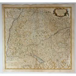
Cercle de Souabe...
The Circle of Swabia, or Swabian Circle, was an Imperial Circle of the Holy Roman Empire established in 1500 on the territory of the former German stem-duchy of Swabia. T...
Place & Date: Paris, 1751
Selling price: $10
Sold in 2018
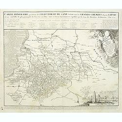
Carte Itineraire par le Pays de l'Electorat de Saxe faisant voir les Grands Chemins depuis Lipsic jusqu' aux Villes les plus principales des Pays Circonvoisins. . .
Detailed map of post road mapsroad system around Leipzig, prepared by J. C. K. Reichenb. Varisco in 1728. The map has a French title in top and the distances marked betwe...
Place & Date: Nuremberg, 1752
Selling price: $180
Sold in 2011
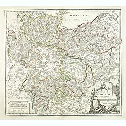
Cercle de Basse Saxe. . .
Detailed map of Northern Germany. Relief shown pictorially. Ornamental cartouche from his "Atlas Universel".Gilles Robert de Vaugondy (1688–1766), also known ...
Place & Date: Paris, 1752
Selling price: $20
Sold in 2015
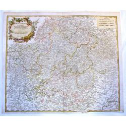
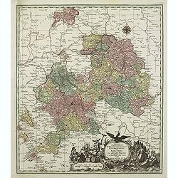
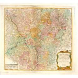
Cercle de Franconie Qui Comprehend Les Eveches de Wurtzbourg.
Fine Vaugondy map of Franconia, Germany centered on Würtzburg, Nuremberg & Bamberg. Engraved by Catherine Haussard and included in "ATLAS UNIVERSELLE". Fea...
Place & Date: Paris, 1752
Selling price: $10
Sold in 2017
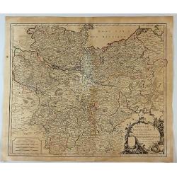
Cercles de Basse Saxe.
A German map including the northern Duchy's of Holstein, Mecklenbourg, Eveches, Hildesheime and Halbersstadt, including the river Elbe, with Hamburg until Potsdam.In the ...
Place & Date: Paris, 1752
Selling price: $16
Sold in 2017
Cercle de Franconie...
A detailed 1752 map of the Circle of Franconia, Germany by de Vaugondy. Franconia is a region in Germany, and it commonly refers to the eastern part of the historical Fr...
Place & Date: Paris, 1752
Selling price: $16
Sold in 2019
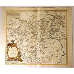
Territorium Seculare Episcopatus Wormatiensis. . .
Johann Baptist Homann's well-engraved map has a large decorative title cartouche with a vineyard and two vine tendrils with the episcopal coat of arms. A fine and detaile...
Place & Date: Nuremberg, 1752
Selling price: $45
Sold in 2020
Circulus Saxoniae Inferioris in omnes suos Status et Principatus. . .
Homann's detailed map of Germany's Lower Saxony region, extending from the Baltic to Berlin, Hall, Gottingen, Bremen and Minden, centered on the course of the Elbe River....
Place & Date: Nuremberg, ca 1752
Selling price: $11
Sold in 2021
Carte des Cercles du Haut et du Bas Rhin.
Fine engraved hand-colored map of Rhineland Germany. With decorative title cartouche featuring a bishop's hat & miter and king's crown. The River Rhine flows through ...
Place & Date: Paris, 1753
Selling price: $11
Sold in 2015
Carte des Cercles du Haut et du Bas Rhin...
An attractive detailed map of the Upper Rhine and Lower Rhine regions in western Germany. This area, known as Rhineland-Palatinate, it covers from Saarbrucken north to Pa...
Place & Date: Paris, 1753
Selling price: $17
Sold in 2017
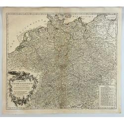
L'Empire d'Allemagne..
Fine map of Germany, with decorative title cartouche. George Louis Le Rouge was active from 1740- till 1780 as a publisher, and was appointed engineer for the King of Fra...
Place & Date: Paris 1756
Selling price: $35
Sold
La Baviere..
Fine map of Bavaria, with decorative title cartouche. George Louis Le Rouge was active from 1740- till 1780 as a publisher, and was appointed engineer for the King of Fra...
Place & Date: Paris 1756
Selling price: $10
Sold
La Souabe.
Fine map of Schwaben, with decorative title cartouche and another cartouche in lower left corner. With manuscript notes in top, left and right margins giving some histori...
Place & Date: Paris 1756
Selling price: $45
Sold in 2021
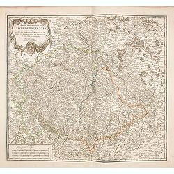
Cercle de la Haute Saxe.
Fine map of Saxony, with decorative title cartouche. George Louis Le Rouge was active from 1740- till 1780 as a publisher, and was appointed engineer for the King of Fran...
Place & Date: Paris 1756
Selling price: $10
Sold in 2018
L'Electorat de Cologne, Le Duché de Bergue et Juliers.
Fine map of the south-eastern part of North Rhine-Westphalia, around Düsseldorf and Cologne. With decorative title cartouche. George Louis Le Rouge was active from 1740 ...
Place & Date: Paris 1756
Selling price: $10
Sold in 2020
La Franconie.
Fine map of the German region Baden-Württemberg, with decorative title cartouche. With manuscript notes in left margin giving some historical information about the regio...
Place & Date: Paris 1756
Selling price: $10
Sold in 2020

Carte de L'Empire D'Allemagne divisé en ses dix cercles,...
Detailed engraved map of all of Germany, extending to Northern Italy, Poland, Austria, Switzerland, the Benelux, and France. Filled with topographical information: Citie...
Place & Date: Paris, 1756
Selling price: $8
Sold in 2011
Carte de L'Empire D'Allemagne Divise en Ses Dix Cercles.
A detailed map of Germany, including the Low Countries, Bohemia and Poland. It shows political divisions, numerous place names, rivers and topography. It is decorated by ...
Place & Date: Paris, 1756
Selling price: $40
Sold in 2017
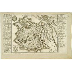
München.
Very rare bird's-eye plan of Munich. To the sides a historical description and a numbered key.George Christophe Kilian (1709-1780) active as engraver of Augsburg publishe...
Place & Date: Augsburg 1757
Selling price: $140
Sold
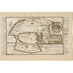
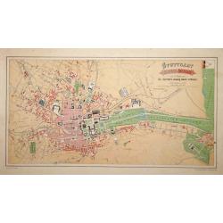
Stutgart.
Very rare bird's-eye plan of Stuttgart. To the sides a historical description and a numbered key.George Christophe Kilian (1709-1780) active as engraver of Augsburg publi...
Place & Date: Augsburg 1757
Selling price: $150
Sold
![Cölln. [Cologne]](/uploads/cache/17380-250x250.jpg)
Cölln. [Cologne]
Very rare bird's-eye plan of Cologne. To the sides a historical description and a numbered key.George Christophe Kilian (1709-1780) active as engraver of Augsburg publish...
Place & Date: Augsburg 1757
Selling price: $150
Sold
Carte Generale du Royaume de Boheme du Duche de Silesie et des Marquisats de Moravie et de Lusace. . .
Lovely copper engraved map shows Bohemia, Lustia & Silesia with high detail of cities, towns, rivers, lakes, mountains & forests. Features beautiful, ribboned, he...
Place & Date: Nuremberg, 1757
Selling price: $250
Sold in 2013
Evache de Paderborn.
Fine large map of the Archdiocese of Paderborn. It is an Archdiocese of the Latin Rite of the Roman Catholic Church in Germany. It was a diocese from its foundation in 79...
Place & Date: Paris, 1757
Selling price: $15
Sold in 2020
Carte de l'Empire d'Allemagne ou sont marquees exactement les routes des postes.
A stunning, scarce 1757 map of the German Empire by Robert de Vaugondy. It covers from Dunkirk in the east of France to Elblag in Poland, and south as far as the Gulf of ...
Place & Date: Paris, 1757
Selling price: $65
Sold in 2019
Charte Braunscheweigisch Luneburgischen Communion Hartze . . .
Manuscript drawn by L.F. Knorre in 1757 after information provided by J.H. Eggers. Showing part of the Duchy of Brunswick-Luneburg in what is now northern Germany.The map...
Place & Date: Germany, 1757
Selling price: $1200
Sold
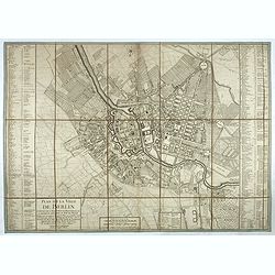
Plan de la ville de Berlin capitale de l'Électorat de Brandebourg et la résidence ordinaire du roi de Prusse. Berlin et Amsterdam, Sr. Neaulm, 1757.
Superb and very rare planof Berlin, reduced after a 4 sheet plan made under the direction of the Count of Schmettau. The map was co-published in Amsterdam and Berlin by J...
Place & Date: Berlin, Amsterdam, 1757
Selling price: $1150
Sold in 2017
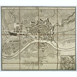
Plan de Cassel vérifié par Léopold capitaine ingénieur.
Beautiful town-plan of Kassel in Bavaria, reviewed by the captain engineer Johann Christian Leopold.Below right, an inset map of Kassel and its surroundings. The north is...
Place & Date: Paris, 1757
Selling price: $150
Sold in 2017
Carte de l'empire d'Allemagne. . .
Detailed map of Germany from his "Atlas Universel".Gilles Robert de Vaugondy (1688–1766), also known as Le Sieur or Monsieur Robert, and his son, Didier Rober...
Place & Date: Paris, 1757
Selling price: $60
Sold
Detailed plan of Krefeld. . .
Detailed plan of Krefeld showing the battle of 23 June 1758 between Duke Ferdinand van Brunswyk and the French army under command of the Duke of Clermond. With extensive ...
Place & Date: Amsterdam, 1758
Selling price: $60
Sold in 2019
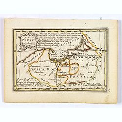
Prussia.
An attractive 18th century miniature map of Prussia which was drawn and engraved by John Gibson for the pocket atlas, Atlas Minimus Illustratus: Containing Fifty-Two Pock...
Place & Date: London, 1758
Selling price: $12
Sold in 2021
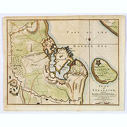
Plan of Stralsund, with the Trenches Lines & Batteries. . .
Stralsund is a Hanseatic town in the Pomeranian part of Mecklenburg-Vorpommern, in Germany. It is located at the Southern coast of the Strelasund, a sound of the Baltic S...
Place & Date: London, 1758
Selling price: $14
Sold in 2021
Stuttgart 1846 u. 1871.
A very detailed plan of Stuttgart. Showing the situation of 1846 and the expansion of 1871. Lithographed by H.A.Schurath and printed by "Dampfsnellpressendruck v.A G...
Place & Date: Augsburg 1760
Selling price: $30
Sold
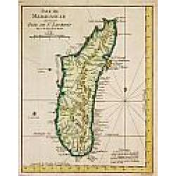
Isle de Madagascar autrement Isle de St. Laurent, 1747.
Jaques Nicolas Bellin (1702-720) was the most important French hydrographer of the 18th century. Sea-atlas 'Hydrographique Français' , 1756-65, atlas to accompany Prévo...
Place & Date: Amsterdam, c. 1760
Selling price: $160
Sold
Accurate Geographische delineation. . . Des Ammtes grossen Hayn. . .
Very detailed map prepared by Adam Frederic Zürner (1680-1742). Surrounded with legends and decorated in the lower right corner with a plan of a royal campement. The tow...
Place & Date: Amsterdam, 1760
Selling price: $20
Sold in 2016
Prospect und Grundris der Keiserl. Freyen Reichs und Anse Stadt Bremen . . .
Decorative town plan of Bremen with surrounding area. In lower part a fine panoramic view.
Place & Date: Nuremberg , ca. 1760
Selling price: $230
Sold in 2016
Circuli Super. Saxoniae Pars Meridionalis . . .
Map of a large part of Germany and a part of the Czech Republic. The map includes the cities: Prague, Berlin, Frankfurt, Magdeburg, Brandenburg, Halle, Leipzig and Dresde...
Place & Date: Augsburg, 1760
Selling price: $50
Sold in 2016
A Map of the Southern Part of Lower Saxony. . .
A magnificent copper engraved map of the southern part of Lower Saxony or Hanover, Germany engraved by George Rollos, and published by J. Coote in London in 1760. It fea...
Place & Date: London, 1760
Selling price: $21
Sold in 2019
Ducatus Iuliacensis, Cliviensis et Montensis, ut et Principatus Meursiani et Comitatus Zutphaniensis Novissima et Accuratissima Delineatio.
Map of North Rhine-Westphalia (Germany) featuring the Duchies of Iuliacensis, Cliviensis and Berg. The map has a very large cartouche featuring five crests with crowns, a...
Place & Date: Augsburg, 1761
Selling price: $30
Sold in 2019
Circuli Westphaliae Quoad Partem Septentrionalem. . .
A fine detailed regional map of Westphalia in Germany, extending from Bremen and Hamburg in the north to Cologne, Bonn, Dusseldorf, Aix, Wyck and Luttich in the south. Ar...
Place & Date: Nuremberg, 1761
Selling price: $21
Sold in 2019
Circuli Westphaliae. . .
A nice, detailed map of Westphalia. Larger towns and cities are highlighted in red - these include, Bremmen, Hamburg, Cologne, Aix, Bonn, Munster, Meppen, Hannover, Emden...
Place & Date: Nuremberg, 1761
Selling price: $17
Sold in 2021
Chorographie du Cercle de Franconie D'Apres Valck et Hubner.....
Fine detailed map of the Franconia region of Germany. Franconia (in German Franken) is a geographical and historical region of south-central Germany. Since 1815 it was a...
Place & Date: Paris, 1763
Selling price: $11
Sold in 2018
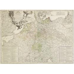
Neue und vollstandige Postkarte durch ganz Deutschland : Mit Kayserl. allergnad. Privilegio / verfertigt von Iohann Iacob von Bors zu Overen . und nach seinem Ableben ubersehen von Franz Ioseph Heger. . .
A uncommon post road mapspost route map of Germany, Poland, Austria, Switzerland and the Low countries. Highly detailed map, showing post offices with the intermediate di...
Place & Date: Nuremberg, 1764
Selling price: $180
Sold in 2012
Carte D'Allemagne: Pour Servir A L'Intelligence De L'Histoire De La Guerre Entre Roys de France et D'Angleterre; Entre le Roy de Prusse et L'Impératrice Reine, L'Electeur De Saxe, L'Empire, La Suede, Et La Russie.
Large map on two sheets of Germany, Poland, the Netherlands, Belgium, Northern parts of France, Luxemburg and northern Italy.In lower left and right hand corners a two co...
Place & Date: Paris, Beaurain, 1765
Selling price: $200
Sold in 2013
A New & Accurate Map of the Kingdom of Prussia and Polish Prussia.
The map covers the area from Pomerania east to Lithuania. Shows numerous place names, rivers and topography. Decorated by a decorative title cartouche. Compass rose and m...
Place & Date: London, 1765
Selling price: $25
Sold in 2021
![[No title] Carte générale d'Allemagne divisée et numérotée...des postes et autres routes de cet empire.](/uploads/cache/29259-250x250.jpg)
[No title] Carte générale d'Allemagne divisée et numérotée...des postes et autres routes de cet empire.
Map representing western part of Germany and Belgium.A so called post road mapspost route map.Desnos, born in a small village close to Beauvais, was apprenticed to Joseph...
Place & Date: Paris, 1766
Selling price: $40
Sold in 2011
![[No title] Carte générale d'Allemagne divisée et numérotée...des postes et autres routes de cet empire.](/uploads/cache/29258-250x250.jpg)
[No title] Carte générale d'Allemagne divisée et numérotée...des postes et autres routes de cet empire.
Map representing a northern part of Germany, with the province of Saxen the western part of Poland. A so called post road mapspost route map.Desnos, born in a small villa...
Place & Date: Paris, 1766
Selling price: $55
Sold in 2015
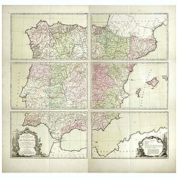
Nouvelle carte géographique des postes et autres routes d'Allemage,
Six double page original hand-colored engraved post road maps maps of Germany, Low Countries, Poland and Austria. A decorative cartouche is on the upper left corner and a...
Place & Date: Paris, 1766
Selling price: $250
Sold in 2019
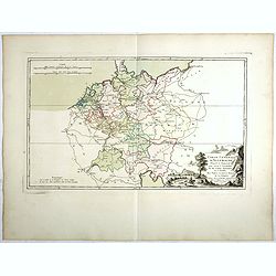
Carte Génerale d'Allemagne, Divisée et Numerotée pour servir à l'assemblage de la Carte Suivante . . .
Double page original hand-colored engraved keymap of the six sheet post road maps map of Germany, Low Countries, Poland and Austria. A decorative cartouche is on the lowe...
Place & Date: Paris, 1766
Selling price: $50
Sold in 2019
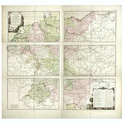
Carte d'Espagne et de Portugal, comprenant les routes des postes et autres de ces deux roiaumes.? . .
Six double page original hand-colored engraved post road maps maps of Spain and Portugal. A decorative cartouche is on the lower left corner and a decorative map legend i...
Place & Date: Paris, 1766
Selling price: $425
Sold in 2017
A New & Accurate Map of Germany, divided into its Circles. . .
An attractive map of Germany by the Englishman Emanuel Bowen. With plenty of good map detail, and set off with a decorative title cartouche in upper right corner.Shows fr...
Place & Date: London, ca 1766
Selling price: $46
Sold in 2021
L'Allemagne, Dressee sur les Observations.
Map of Germany
Place & Date: Paris, 1767
Selling price: $13
Sold in 2010

Basse Saxe.
A map of the northwestern German region of Lower Saxony. A map of French origin, published in the late eighteenth or early nineteenth centuries, has informative and inter...
Place & Date: Paris, ca. 1767
Selling price: $1
Sold in 2021
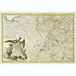
Nieuwe Kaart van de Frankische en Zwabische Kreits.
Izaac Tirion (d. 1769) Amsterdam publisher. His 'Nieuwe en beknopte handatlas' saw 6 editions between before 1740 and after 1784. Also 'Tegenwoordige staat van alle volke...
Place & Date: Amsterdam, c. 1770
Selling price: $140
Sold
Carte de l'Empire d'Alemagne..
Detailed map depicting parts of France, Switzerland and Germany. Embellished with allegorical cartouche.
Place & Date: Paris, 1770
Selling price: $30
Sold
![[Part of an Unknown Map.]](/uploads/cache/98331-250x250.jpg)
[Part of an Unknown Map.]
Upper left sheet of a large four sheet map. The most pronounced label on he map is "Comte de Virnenborg", Virneburg is a municipality in the district of Mayen-K...
Place & Date: Paris, ca. 1770
Selling price: $16
Sold in 2017
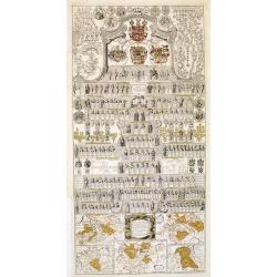
Vorstellung der Sächsischen Historie daraus die ge sämtlichen Regenten.
A decorative plate with hundreds of Kings of Saxony; with in bottom five maps of the region of Saxony during different periods.The map in lower right showing the foundati...
Place & Date: Berlin, 1771
Selling price: $325
Sold in 2013