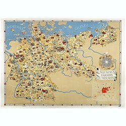
L'Allemagne au paradis du tourisme.
Iconographic map of Germany designed by Walter Riemer, published during pre world war II, by Reichsbahnzentrale. This propaganda paper was published in preparation for th...
Place & Date: Berlin, 1936
Selling price: $410
Sold in 2017
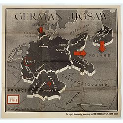
German Jigsaw.
BONUS Map depicting Germany separated into a jigsaw puzzle. "Enlargement of original map drawn for TIME the weekly news magazine" according to note in right han...
Place & Date: New York , Time Magazine, 1944
Selling price: $200
Sold in 2017
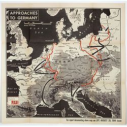
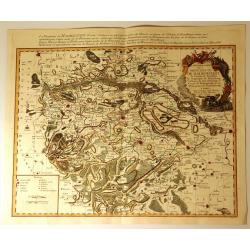
Approaches to Germany.
BONUS Map depicting possible routes into Germany from Russia, France, and Italy. "Enlargement of original map drawn for LIFE" according to note in lower left co...
Place & Date: New York , Time Magazine, 1944
Selling price: $151
Sold in 2018
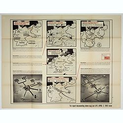
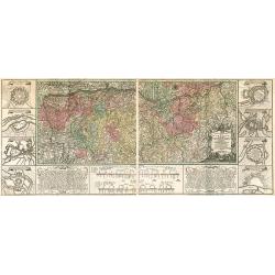
Germany's critical minerals
BONUS Map depicting 5 maps showing German steel, airplane, petroleum, etc. production around 1944. Design by Jerry Muscott (Enlargement reprint for Life Magazine, April 2...
Place & Date: New York , Life Magazine, 1945
Selling price: $210
Sold in 2017
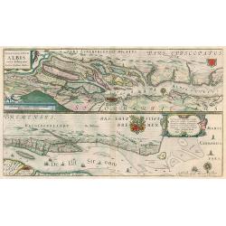
Celeberrimi Fluvii Albis nove delineation.
Hamburg area & Elbe river by Blaeu. Latin text on verso.
Place & Date: Amsterdam, 1644-45
Selling price: $100
Sold in 2010
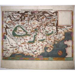
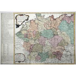
Teutschland,mit seinem gantzen begriff und eingeschlossnen Landschafften.
A fine antique woodcut map of Germany by Sebastian Münster, ca 1550, Basel. From a German edition of his 'Cosmography'.Germany, with parts of the Netherlands, Austria, S...
Place & Date: Basel, ca 1550
Selling price: $170
Sold in 2020
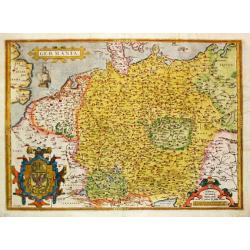
Germania. . .
A map of Germany from Abraham Ortelius’ "Theatrum Orbis Terrarum" is probably based on the map by Christaan Sgrooten. Embellished with a large title-cartouche...
Place & Date: Antwerp, 1571.
Selling price: $200
Sold in 2021
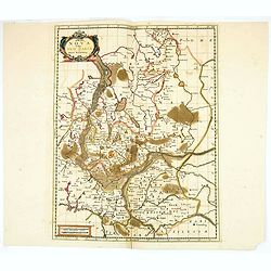
MARCA BRANDEBURGENSIS & POMERANIA.
Gerard Mercator (1512-94). His 'Atlas sive Cosmographica' was posthumously published in 1595. Jodocus Hondius (1563-1612), a founder of the Hondius publishing house, acqu...
Place & Date: Amsterdam, 1613.
Selling price: $310
Sold
Marchia Nova Vulgo New Marck in March Brandenburg.
Hand-colored copper engraving by Moses Pitt and Stephan Swart. Published in Amsterdam, 1695.
Place & Date: Amsterdam, 1695.
Selling price: $20
Sold in 2020
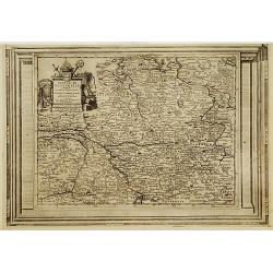
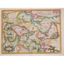
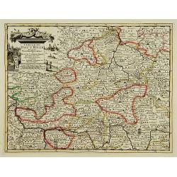
Cercle de Westphalie, suivant les nouvelles observations..
With decorative title cartouche upper left corner.This example is unusual in having the additional separately engraved decorative framework border around the map, the res...
Place & Date: Amsterdam 1728.
Selling price: $70
Sold
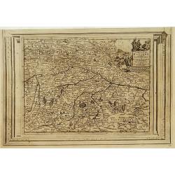
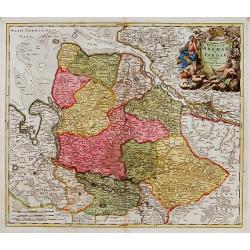
Cercle de Bavière, suivant les nouvelles observations..
With decorative title cartouche upper right corner.This example is unusual in having the additional separately engraved decorative framework border around the map, the re...
Place & Date: Amsterdam 1728.
Selling price: $90
Sold
Charte Geographique de la Campagne du Haut Rhin...
Large map by J.F. Oettinger on 2 sheets.
Place & Date: Augsburg, 1740.
Selling price: $300
Sold in 2009
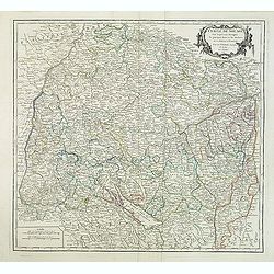
Cercle de Souabe. . .
Finely and crisply engraved map of south part of Germany. Ornamental title cartouche in the upper part of map from his "Atlas Universel".Gilles Robert de Vaugon...
Place & Date: Paris, 1751.
Selling price: $20
Sold in 2015
Partie Septentrionale du Cercle d'Autriche...
Map showing the postal routes in The Netherlands, Belgium, France, Poland, Austria, Switzerland and Northern Italy. With an ornamental cartouche.
Place & Date: Paris, 1752.
Selling price: $104
Sold
Carte Particuliere de la Principaute de Halberstadt
Carte Particuliere de la Principaute de Halberstadt. A large and rare map of Halberstadt, Germany, and its surroundings by Le Rouge. Showing the town in the German state...
Place & Date: Paris, 17576
Selling price: $112
Sold in 2015
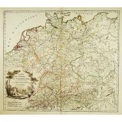
La ALEMANIA dividida en sus principales Estados segun las ultimas y nuevas observationes de las Accademias y de Paris y de Londres.
A beautiful, rare colored map of Germany by the Spanish cartographer Pedro Gendron. As in most 18th century maps published in Spain, which are based upon non-Spanish sour...
Place & Date: Madrid(?), ca 1760
Selling price: $150
Sold in 2020
Lot of 3 maps of Germany.
Robert de Vaugondy: Empire d'Allemagne, 24 cm x 28 cm. Van der AA : Cercle du Haut Rhin, 22,5cm x 29 cm: L'Allemagne, 22,5 cm x 29 cm.The three maps are well-engraved.
Place & Date: Paris/ Leiden
Selling price: $40
Sold
Ducatus Bremae et Ferdae nova tabula.
A very decorative and detailed map with Hamburg on the river Elbe. Also including Oldenburg and Bremen. With a very decorative title cartouche showing putti and allegoric...
Place & Date: Nuremberg, 18th century
Selling price: $150
Sold