Browse Listings in Europe > France > France Provinces
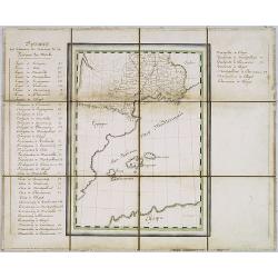
Manuscript map of the Southern Provinces of France.
Very detailed manuscript folding-map of the southern part of France. Including Lyon, Nice, Marseilles, Toulouse.Including the Balearic Islands of Majorca, Minorca, Ibiza....
Place & Date: France ca. 1850
Selling price: $475
Sold in 2020
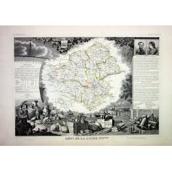
Lot of 4 French Departements
Four very decorative engraved maps of the French Departements: Haut Rhin, Loire, Lozère, Doubs. Ornately decorated borders, vignette scenes, portraits and views of the r...
Place & Date: Paris, 1850
Selling price: $50
Sold
![Dépt. Des Bes. Du Rhône. N°12. [ Marseille, Arles, Aix ]](/uploads/cache/27091-250x250.jpg)
Dépt. Des Bes. Du Rhône. N°12. [ Marseille, Arles, Aix ]
Map of the region around Marseille, Arles, Aix in the south of France.Lovely map from one of the last decorative atlases of the nineteenth century.The rather simple map i...
Place & Date: Paris, A. Combette, 1852
Selling price: $80
Sold in 2010
![Dépt. De La Charente. N°13. [ Cognac ]](/uploads/cache/27094-250x250.jpg)
Dépt. De La Charente. N°13. [ Cognac ]
Map of the Charente region, centered on Angouleme and Cognac. Home of the world's best-known brandy, the map shows the countryside surrounding the Charente River one hund...
Place & Date: Paris, A. Combette, 1852
Selling price: $50
Sold in 2023
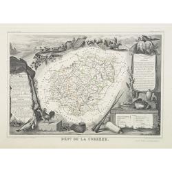
Dépt. De La Corrèze. N°18.
Map of the Corrèze region in France.Lovely map from one of the last decorative atlases of the nineteenth century.The rather simple map is framed by medallion portraits a...
Place & Date: Paris, A. Combette, 1852
Selling price: $30
Sold in 2009
![Dépt. De La Côte D'Or. N°20. [ Lyon ]](/uploads/cache/27099-250x250.jpg)
Dépt. De La Côte D'Or. N°20. [ Lyon ]
Map of the Burgundy area, centered on Lyon.Lovely map from one of the last decorative atlases of the nineteenth century.The rather simple map is framed by medallion portr...
Place & Date: Paris, A. Combette, 1852
Selling price: $50
Sold in 2009
![Dépt. Des Côtes Du Nord. N°21. [ St.Brieuc and St.Malo ]](/uploads/cache/27100-250x250.jpg)
Dépt. Des Côtes Du Nord. N°21. [ St.Brieuc and St.Malo ]
Map of the northern part of Brittany, including the towns of St.Brieuc and St.Malo, Dinan, etc.Lovely map from one of the last decorative atlases of the nineteenth centur...
Place & Date: Paris, A. Combette, 1852
Selling price: $65
Sold
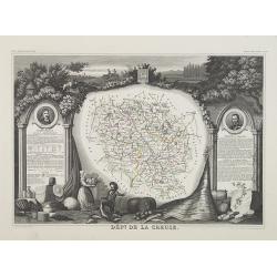
Dépt. De La Creuse. N°22.
Map of the Creuse region in France.Lovely map from one of the last decorative atlases of the nineteenth century.The rather simple map is framed by medallion portraits and...
Place & Date: Paris, A. Combette, 1852
Selling price: $35
Sold in 2009
![Dépt. Du Doubs. N°24. [ Besançon ]](/uploads/cache/27103-250x250.jpg)
Dépt. Du Doubs. N°24. [ Besançon ]
Map of the Doubs region, centered on the town Besançon in France.Lovely map from one of the last decorative atlases of the nineteenth century.The rather simple map is fr...
Place & Date: Paris, A. Combette, 1852
Selling price: $30
Sold in 2009
![Dépt. De La Dordogne. N°25. [ Perigueux ]](/uploads/cache/27104-250x250.jpg)
Dépt. De La Dordogne. N°25. [ Perigueux ]
Map of the Dordogne region, centered on Perigueux in France.Lovely map from one of the last decorative atlases of the nineteenth century.The rather simple map is framed b...
Place & Date: Paris, A. Combette, 1852
Selling price: $50
Sold in 2010
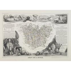
Dépt. De L'Eure. N°26.
Map of the Eure a region in France, including the area south of the River Seine from Vernon to Le Havre.Lovely map from one of the last decorative atlases of the nineteen...
Place & Date: Paris, A. Combette, 1852
Selling price: $30
Sold in 2009
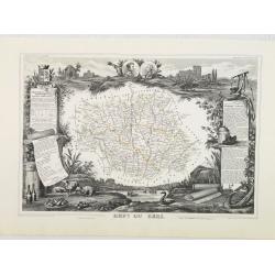
Dépt. Du Gers. N°31.
Map of the Gers region in France.Lovely map from one of the last decorative atlases of the nineteenth century.The rather simple map is framed by medallion portraits and c...
Place & Date: Paris, A. Combette, 1852
Selling price: $50
Sold in 2010
![Dépt. De La Gironde. N°32. [ Bordeaux ]](/uploads/cache/27111-250x250.jpg)
Dépt. De La Gironde. N°32. [ Bordeaux ]
Map of the Gironde region, including Bordeaux in France.Lovely map from one of the last decorative atlases of the nineteenth century.The rather simple map is framed by me...
Place & Date: Paris, A. Combette, 1852
Selling price: $55
Sold in 2009
![Dépt. De L'Hérault. N°33. [ Narbonne, Montpellier ]](/uploads/cache/27112-250x250.jpg)
Dépt. De L'Hérault. N°33. [ Narbonne, Montpellier ]
Map of the Hérault region, including the towns of Narbonne, Montpellier, etc in Southern France.Lovely map from one of the last decorative atlases of the nineteenth cent...
Place & Date: Paris, A. Combette, 1852
Selling price: $30
Sold in 2009
![Dépt. Du Loiret. N°44. [ Orleans ]](/uploads/cache/27123-250x250.jpg)
Dépt. Du Loiret. N°44. [ Orleans ]
Map of the Loire region, centered on the town of Orleans and the region north of the River Loire.Lovely map from one of the last decorative atlases of the nineteenth cent...
Place & Date: Paris, A. Combette, 1852
Selling price: $40
Sold
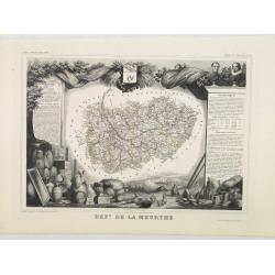
Dépt. De La Meurthe. N°53.
Map of the Meurthe region in France.Lovely map from one of the last decorative atlases of the nineteenth century.The rather simple map is framed by medallion portraits an...
Place & Date: Paris, A. Combette, 1852
Selling price: $50
Sold in 2013
![Dépt. De La Sarthe. N°71. [ Le Mans ]](/uploads/cache/27152-250x250.jpg)
Dépt. De La Sarthe. N°71. [ Le Mans ]
Map of the Sarthe region, centered on Le Mans.Lovely map from one of the last decorative atlases of the nineteenth century.The rather simple map is framed by medallion po...
Place & Date: Paris, A. Combette, 1852
Selling price: $50
Sold in 2010
![Dépt. De Vaucluse. N°81. [ Avignon, Carpentras, Apt ]](/uploads/cache/27161-250x250.jpg)
Dépt. De Vaucluse. N°81. [ Avignon, Carpentras, Apt ]
Map of the Vaucluse region in France, including Avignon, Carpentras, Apt, etc.Lovely map from one of the last decorative atlases of the nineteenth century.The rather simp...
Place & Date: Paris, A. Combette, 1852
Selling price: $50
Sold in 2017
![Dépt. De La Vienne. N°83. [ Poitier ]](/uploads/cache/27164-250x250.jpg)
Dépt. De La Vienne. N°83. [ Poitier ]
Map of the Vienne region in France, centered on the town Poitier.Lovely map from one of the last decorative atlases of the nineteenth century.The rather simple map is fra...
Place & Date: Paris, A. Combette, 1852
Selling price: $30
Sold in 2009
![Dépt. De La Hte. Vienne. N°84. [ Limoges]](/uploads/cache/27165-250x250.jpg)
Dépt. De La Hte. Vienne. N°84. [ Limoges]
Map of the Upper Vienne region, centered on the town Limoges, famous for its porcelain.Lovely map from one of the last decorative atlases of the nineteenth century.The ra...
Place & Date: Paris, A. Combette, 1852
Selling price: $30
Sold in 2009

Le Vie Ferrate e le Postali della Francia Meridionale . . .
Uncommon map of South of France and part of Spain prepared by Francesco Costantino Marmocchi. Above the map "Geografia Commerciale". From "Il Globo Atlante...
Place & Date: Genova, Paolo Rivara fu Giacomo, 1858
Selling price: $10
Sold in 2020
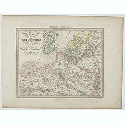
Le Vie Ferrate e le Postali della Francia Settentrionale . . .
Uncommon map of North of France and part of Belgium and England prepared by Francesco Costantino Marmocchi. Above the map "Geografia Commerciale". From "Il...
Place & Date: Genova, Paolo Rivara fu Giacomo, 1858
Selling price: $10
Sold in 2020
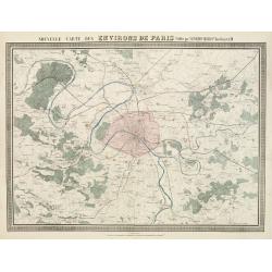
Nouvelle Carte des Environs de Paris.
Fine map of Paris and its contiguous outskirts, showing the early railway system of the area.From Atlas des Chemins de Fer published by Napoléon Chaix and printed by Imp...
Place & Date: Paris, 1863
Selling price: $10
Sold in 2011
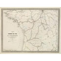
Carte du Chemin de Fer d'Orléans..
Fine map showing the early railway system of a large area extending westwards and southwards from Paris.From Atlas des Chemins de Fer published by Napoléon Chaix and pri...
Place & Date: Paris 1863
Selling price: $4
Sold in 2011
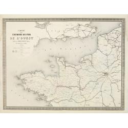
Carte des Chemins de Fer de l'Ouest..
Fine map showing the early railway system of a large area extending westwards from Paris as far as the coasts of Brittany.It includes part of the northern regions and the...
Place & Date: Paris 1863
Selling price: $90
Sold
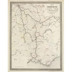
Carte des Chemins de Fer de Paris à Lyon et à la Méditerranée.
Fine map showing the early railway system of a large area extending from Paris to South East France.From Atlas des Chemins de Fer published by Napoléon Chaix and printed...
Place & Date: Paris 1863
Selling price: $6
Sold in 2011
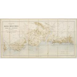
Cartes des Alpes Maritimes Littoral de la Méditerranée aux environs de Fréjus, Cannes, Grasse, Antibes, Nice, Monaco et Menton.
Folding-map of the Maritime Alps and the Mediterranean coastline of Fréjus, Cannes, Grasse, Antibes, Nice, Monaco, and Menton. Engraved by Erhard, geographer and engrave...
Place & Date: Paris, 1870
Selling price: $80
Sold in 2008
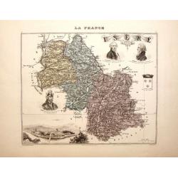
La France - Isere.
Nice decorated hand colored map of the Isere department of France. There are five cartouches including portraits of Vaucanson, Barnave & Bayart, the city of Grenoble ...
Place & Date: Paris, 1878
Selling price: $33
Sold in 2014
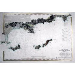
Carte particulière des cotes de France Dept. du Var...
Very large sea chart of a part of the Provence - Côte d'Azur region. From Hyères to Cap Camarat. Includes Ile de Porquerolles, Port-Cros, Ile du Levant. Dated 1843 but ...
Place & Date: Paris, 1879
Selling price: $81
Sold in 2016
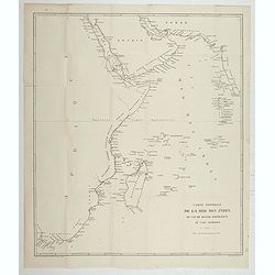
Carte Générale de la Mer des Indes du Cap Bonne Espérance au Cap Comorin.
Map of a part of the Indian Ocean, from Cape of Good Hope to Comorin Cape. Printed by Imp. Dufrénoy, in Paris.
Place & Date: Paris, 1888
![[Les anciennes provinces Françaises à la ville de Saint Denis].](/uploads/cache/41682-250x250.jpg)
[Les anciennes provinces Françaises à la ville de Saint Denis].
Nine small chromolithography's trade cards for Ville de Saint Denis, each with French regions and places, with description in French on each verso.Cards of the regions : ...
Place & Date: Paris, circa 1900
Selling price: $55
Sold in 2018
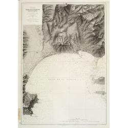
Mer Méditerranée - Côte de France - Golfe de la Napoule Rade de Cannes. . .
Large centered on the Gulf of La Napoule with the harbour of Cannes, the islands Sainte Marguerite and Saint Honorat on the right side. Showing towns, buildings, banks, ...
Place & Date: Paris, 1903 updated 1931
Selling price: $600
Sold
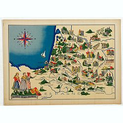
Basque - Bearn - Bigorre.
Very decorative, informative map of Basque - Bearn - Bigorre in south western France. Including the towns of Biarritz, Dax, Bayonne, Lourdes, etc. The map is filled with ...
Place & Date: France, 1943
Selling price: $90
Sold in 2013
Basque - Bearn - Bigorre.
Very decorative, informative map of Basque - Bearn - Bigorre in south western France. Including the towns of Biarritz, Dax, Bayonne, Lourdes, etc. The map is filled with ...
Place & Date: France, 1943
Selling price: $65
Sold in 2014
Basque - Bearn - Bigorre.
Very decorative, informative map of Basque - Bearn - Bigorre in south western France. Including the towns of Biarritz, Dax, Bayonne, Lourdes, etc. The map is filled with ...
Place & Date: France, 1943
Selling price: $60
Sold in 2016
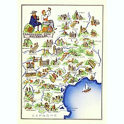
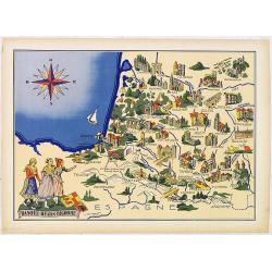
Languedoc - Foix Roussillon.
Very decorative, informative map of Languedoc - Foix Roussillon region in south eastern France. Including the towns of Carcassonne, Montpellier,, Albi, Toulouse, etc.The ...
Place & Date: France, 1943
Selling price: $95
Sold in 2016
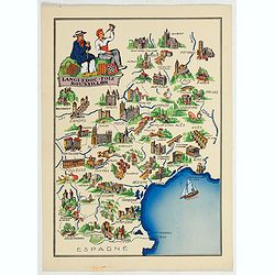
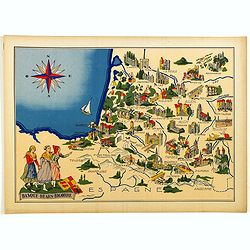
Languedoc - Foix Roussillon.
This is a very decorative, informative map of the Languedoc - Foix Roussillon region in southeastern France, including the towns of Carcassonne, Montpellier,, Albi, Toulo...
Place & Date: France, 1943
Selling price: $40
Sold in 2023
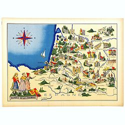
Languedoc - Foix Roussillon.
Very decorative, informative map of Languedoc - Foix Roussillon region in south eastern France. Including the towns of Carcassonne, Montpellier,, Albi, Toulouse, etc.The ...
Place & Date: France, 1943
Selling price: $40
Sold in 2022
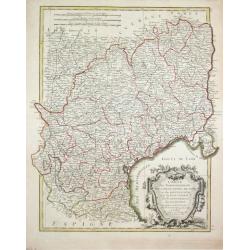
Carte du Bearn de la Bigorre de l'Armagnac..
Map of south-west part of France covering the Landes country with Dax, Bayonne and Pau till Montauban and Toulouse on the right.
Place & Date: Paris [c. 1780]
Selling price: $120
Sold
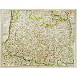
Carte des Gouvernements de Languedoc, de Foix et de Rousillon avec la Partie Oreintale du Gouvernement de Guienne.
Jean Lattré, Paris-based engraver and publisher. Worked with Robert de Vaugondy, J. Janvier and R. Bonne. " Atlas Monderne', 1771, 1783 , 1793. Rigobert Bonne (1727...
Place & Date: Paris, 1783.
Selling price: $120
Sold