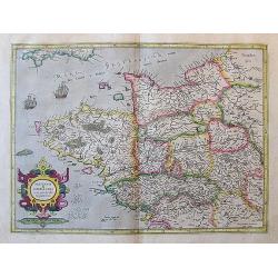
Browse Listings in Europe > France > France Provinces
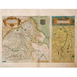
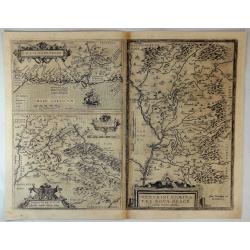
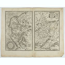
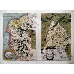
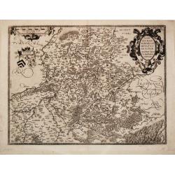
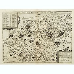
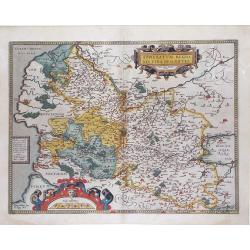
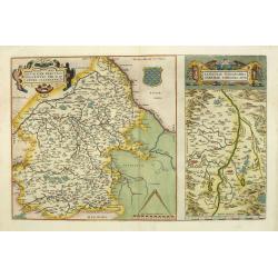
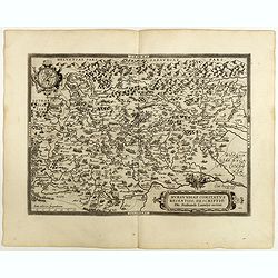
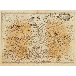
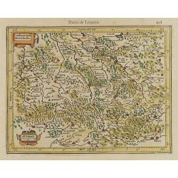
Regionis Biturigum Exactiss Descriptio per D. 10 Annem Calamaeum / Limaniae Topographia Gabriele Symeoneo Auct.
Two detailed regional maps of France by Ortelius showing the regions of Berry and Limagne. Accompanying Latin text is on verso.
Place & Date: Antwerp, 1573
Selling price: $60
Sold in 2010
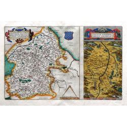
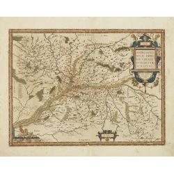
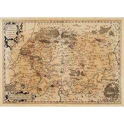
Regionis Biturigum Exactiss Descriptio per D. 10 Annem Calamaeum / Limaniae Topographia Gabriele Symeoneo Auct.
Two detailed regional maps of France by Ortelius showing the regions of Berry and Limagne. Accompanying Latin text is on verso with hand-colored rubric letters. Striking,...
Place & Date: Antwerp, 1573
Selling price: $200
Sold in 2010
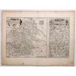
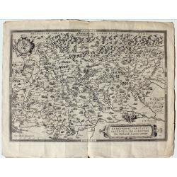
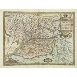
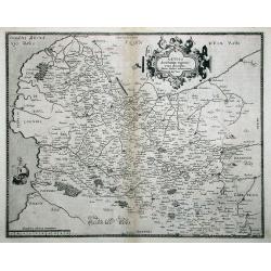
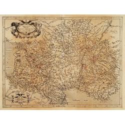
Regionis Biturigum Exactiss / Limaniae Topographia Gabriele.
Two detailed regional maps of France on one page by Ortelius; showing the regions of Berry and Limagne.The larger map covers the Loire region from Gian to Le Blang and Ar...
Place & Date: Antwerp, 1573
Selling price: $100
Sold in 2018
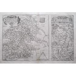
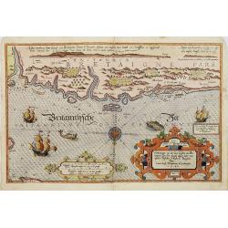
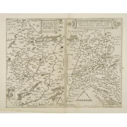
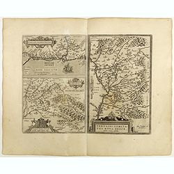
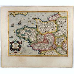
Caletensium et Bononi Ensium Ditionis Accurata delineation / Veromandy Orum Eorum Que Confini.
Two fine Ortelius maps on one sheet. The left hand map shows the Opal Coast (Côte d'Opale) within Pas-de-Calais between Gravelines to Étaples, including Calais & Bo...
Place & Date: Antwerp, 1573
Selling price: $30
Sold in 2018
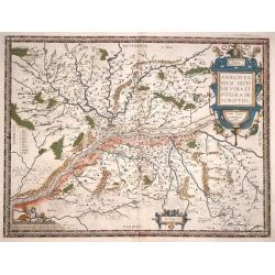
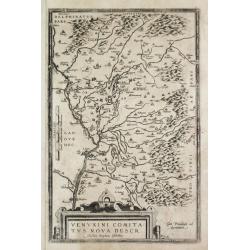
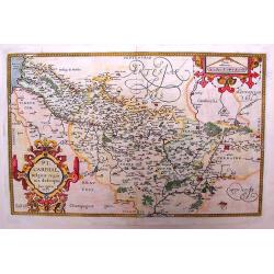
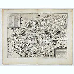
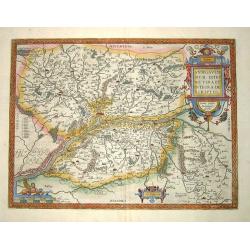
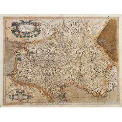
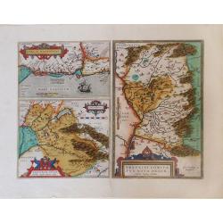
Venuxini Comitatus Nova Descr. / Gallia Narbonensis / Sabaudiae Ducat.
Interesting with three maps on one sheet. Upper left the coast of the Mediterranean Sea (with places like Narbonne, Aigues Mortes, Avignon, Arles etc. In the bottom left ...
Place & Date: Antwerp, 1573
Selling price: $57
Sold in 2018
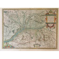
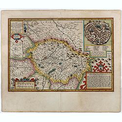
Exacta novaqve descriptio dvcatvs Andegravensis qvem vvlgari nomine Le Duche d'Aniou Indigitant.
Centered on the town of Angiers. From the first edition of De Jode's Speculum Orbis Terrarum, the second general atlas of the world, after Ortelius. Engraved by Ioannes V...
- $750 / ≈ €702
Place & Date: Antwerp, 1578
Picardiae, Belgicae regionis descriptio. Joanne Surhonio auctore
Beautiful original old colored map of the Picardie region in Northwest France by Abraham Ortelius. Showing the Picardy from the sea to Abbeville, Amiens and Laon in the e...
Place & Date: Antwerp, 1579
Selling price: $220
Sold in 2009
Anjou. Andegavensium Ditionis Vera et Integra Descriptio
Beautiful map of the Anjou region of western France along the Loire River. Include the city of Angers in the center. Accompanying text on verso
Place & Date: Antwerp, 1579
Selling price: $70
Sold in 2010
Anjou : Andegavensium ditionis vera et integra descriptio.
Attractive map of the Loire River valley centred on Angers. The map displays the river system with mountains and forests and hundreds of tiny villages. Large strapwork t...
Place & Date: Antwerp, 1579
Selling price: $160
Sold in 2015
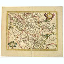
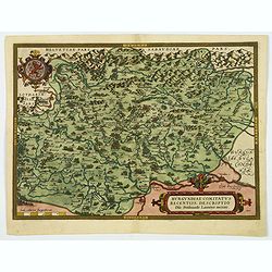
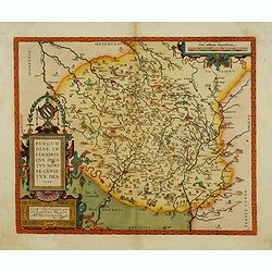
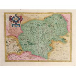
Burgundiae Comitatus Recentiss. Descriptio Dno Ferdinando Lannoyo auctore
From Theatrum Orbis Terrarum. Published in Antwerp, Latin text, “29” on verso.
Place & Date: Antwerp, 1579
![Caletensium Et Bononiensium Ditionis Accurata Delineatio [with] Veromanduorum Eorum Que Confinium Exactissima Descriptio.](/uploads/cache/91526-250x250.jpg)
Caletensium Et Bononiensium Ditionis Accurata Delineatio [with] Veromanduorum Eorum Que Confinium Exactissima Descriptio.
Two finely detailed maps by Ortelius. The map on the left shows the Belgian and French Coastal regions, while the map on the right focuses on a small region surrounding S...
Place & Date: Antwerp, ca. 1580
Selling price: $100
Sold in 2010
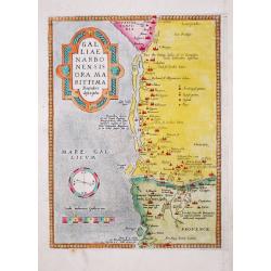
Old antique map of Narbonne Marseille- GAL / LIAE / NARBO / NENSIS / ORA MA / RITTIMA / / Recenter / descriptio.
Abraham Ortelius(1527-98), Dutch cartographer and publisher of the first modern atlas, ' Theatrum Orbis Terrarum' in 1570. Editions till 1612. Also an atlas of ancient ca...
Place & Date: Antwerp, 1580
Selling price: $60
Sold in 2020
Caletensium et Bononiensium.. / Veromandorum. . .
Two maps on one sheet. Left map, entitled Caletensium, depicts the French and Belgian coastline from Estables to Calais. The right map, entitled Veromandorum, depicts the...
Place & Date: Antwerp, 1580
Selling price: $75
Sold in 2016
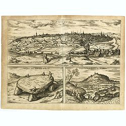
Pictavia vulgo Poictiers / La pierre leuee demie lieue de Poictiers / Prospectus Montis Henrici vulgo Montherri.
Bird's-eye view of Nocera Umbra and Castelnuovo. - From the greatest publication in this genre!. The Civitates was compiled and written by George Braun, Canon of Cologne ...
Place & Date: Cologne, 1580
Selling price: $70
Sold in 2019
1) Caletensivm et Bononiensivm..2) Veromandvorvm eorvmque..
Prepared by Jean Surhon, cartographer, goldsmith and engraver. From 'Theatrum Orbis Terrarum [Atlas of the Whole World]': published in Antwerp.
- $200 / ≈ €187
Place & Date: Antwerp, 1580
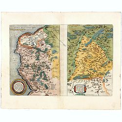
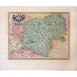
Regionis Biturigum Exactiss: Descriptio per D. Ioannem Calamaeum / Limaniae Topographia Gabriele Symeoneo Auct.
A pair of fine maps on a full folio sheet. The map of Biturigum is centered on Chateau Neuf and Bourges, with the Loire River flowing at the top right of the map to Never...
Place & Date: Antwerp, 1581
Selling price: $45
Sold in 2016
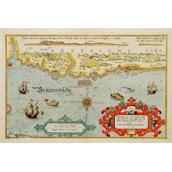
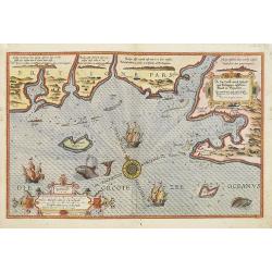
Verthoninghe van de Zee Custen van Bretaignen..
A very decorative chart covering the coast along the coast of Britany. South to the top. A first edition, without the previlegio. Engraved by the master engraver, Johanne...
Place & Date: Amsterdam 1584
Selling price: $1700
Sold
Venuxini Comitatus Nova Descr. Auctore Stephano Ghebellino.
Abraham Ortelius(1527-98), Dutch cartographer and publisher of the first modern atlas, ' Theatrum Orbis Terrarum' in 1570. Editions till 1612. Also an atlas of ancient ca...
Place & Date: Antwerp, 1584
Selling price: $150
Sold
Caletensium Et Bononiensium Ditionis Accurata Delineatio & Veromanduorum Eorum Que Confinium Exactissima Descriptio...
Two detailed regional maps by Ortelius. The first map shows Belgian and French Coastal region, from Etaples to Gravelines, with Calais, Boulogne-sur-Mer. The second map s...
Place & Date: Antwerp, 1584
Selling price: $102
Sold in 2013
Anjou / Andegavensium Ditionis Vera et Integra Desciptio.
Very decorative map of a region in France, centered on the Loire River and Angiers. Highly detailed with hundreds of villages shown, forests, hills, etc. Includes several...
Place & Date: Antwerp, 1584
Selling price: $45
Sold in 2015
Chartae orarum . . . . Caerte vanden zee Custen, eensdeels Normandien, en Brittangen. . .
A detailed chart of the Normandy coast and the channel islands of Jersey, Guernsey, Alderney and Sarck decorated by a colorful title cartouche and scale cartouche, two co...
Place & Date: Leiden, Plantijn, 1585
Selling price: $3400
Sold in 2008
De zee Custe, met de England van Bretaignen, tusschenn Blauet en Picqueliers. . .
DUTCH TEXT EDITION. A detailed chart of the coast of southern part of Brittany, covering the coast from Vannes till Hilaire-de-Riez. Decorated by a colorful title cartouc...
Place & Date: Leiden, Plantijn, 1585
Selling price: $3000
Sold in 2009
Verthoninghe van zee Cuften van Bretaignen. . .
DUTCH TEXT EDITION. A detailed chart of the coast of Brittany decorated by a very colorful title cartouche and scale cartouche, one compass rose, several vessels and sea ...
Place & Date: Leiden, Plantijn, 1585
Selling price: $3000
Sold
Picardiae Belgicae Regio Nis Descriptio
A highly detailed copper engraved map of the Picardie region in Northwest France by Abraham Ortelius. This map is finely engraved with forests, cities, villages along the...
Place & Date: Antwerp, ca. 1585
Selling price: $69
Sold in 2015
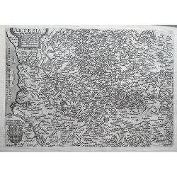
ARTESIA Comit.
Mercator's early map of the northern French region of Artois. Divisions in outline colors, strap-work title cartouche and mileage scale in the upper right, and lower left...
Place & Date: Duisbourg, 1585
Selling price: $12
Sold in 2021

Beschrijvinge vande de zee Cuften va Vlanderen en Picardien. . .
A detailed description of the coast of Picardie and Normandy decorated by a large colored baroque title cartouche, and the coat of arms of Flanders with a colorful scale ...
- $1750 / ≈ €1638
Place & Date: Amsterdam, 1585
Nobilis Hannoniae Comitatus Descrip. 1579.
Abraham Ortelius(1527-98), Dutch cartographer and publisher of the first modern atlas, ' Theatrum Orbis Terrarum' in 1570. Editions till 1612. Also an atlas of ancient ca...
Place & Date: Antwerp, 1588
Selling price: $80
Sold in 2018
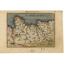
Normandia.
Miniature map of the coast of France at Normandy. Latin text on verso.
Place & Date: Antwerp, 1588
Selling price: $100
Sold
Andegavensium Ditionis Vera et Intregra Descriptio.
Decorative map centered on the Loire River and Angiers. Includes several bridges across the Loire and its tributaries.Prepared by Licimo Guyeto Andegauense.
Place & Date: Antwerp, 1590
Selling price: $220
Sold in 2013
Andegavensium Ditionis Vera et Intregra Descriptio.
Early map of the Loire Valley, with Angiers in the center. Prepared by Lézin Guyet in 1579.
Place & Date: Antwerp, 1590
Selling price: $55
Sold in 2010
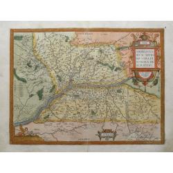
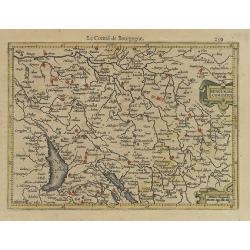
Burgundiae Comitatus Recentiss. Descriptio.
A decorative and attractive regional map of Burgundy in France, that is centered on Besancon, Poligny, Quingey and St Anne. It includes a number of famous wine regions, f...
Place & Date: Antwerp, ca 1590
Selling price: $80
Sold in 2020
Nova et integra caenomaniae descriptio vulg. Le Mans.
Rare map centered on Le Mans.
Place & Date: Antwerp, 1593
Selling price: $130
Sold
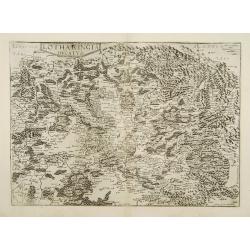
Lotharingia ducatus.
Very rare and beautifully engraved map from De Jode's atlas Speculum Orbis Terrarum . Detailed map of Lorraine.Engraved by Joan and Lucas van Doetecom.RARE.
Place & Date: Antwerp 1593
Selling price: $180
Sold
Typus Corographicus Veromanduae.. / Sabaudiae ducatus..
Very rare and beautifully engraved map from De Jode's atlas Speculum Orbis Terrarum . Detailed map of regions along the river Saône River, including Lyon.Engraved by Joa...
Place & Date: Antwerp 1593
Selling price: $270
Sold
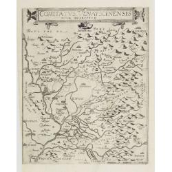
Comitatus Venayscinensis Nova Discriptio.
Rare map depicting part of Provence with Avignon, Cavaillon, Orange, Carpentras, etc.Gerard De Jode was the great rival of Ortelius, both made a living out of selling map...
Place & Date: Antwerp, 1593
Selling price: $280
Sold in 2008
ARTOIS Atrebatum regionis vera descriptio.
De Jode's superb map of Artesia/Flanders. Includes the cities of Calais, Lille, Lens, Arras, Douai, Boulogne-sur-mer,... The map is based on the manuscript map Jacques Su...
Place & Date: Antwerp, 1593
Selling price: $300
Sold in 2011
Nova et integra caenomaniae descriptio vulg. Le Mans.
Fine separately issued example of Gerard De Jode's map of Caenomaniae (Maine Province), from his Speculum Orbis Terrarum. Gérard de Jode (1508? -1590) published in Antwe...
Place & Date: Antwerp, ca. 1593
Artois. Atrebatum Regionis Vera Descriptio.
Map of Artois, a former province at the northwest tip of France, by Abraham Ortelius. Accompanying Latin text with hand-colored rubric letters on verso. Vibrant, original...
Place & Date: Antwerp, c.1595
Selling price: $120
Sold in 2010
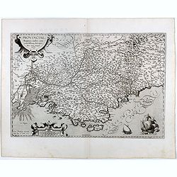
Provinciae, Regionis Galliae, vera exactissimaq. Descriptio..
Early imprint of this decorative map of the Province prepared by Pierre-Jean de Bompar who published a single sheet map of the Province in 1591.Title cartouche on the upp...
Place & Date: Antwerp, 1595
Selling price: $110
Sold in 2016
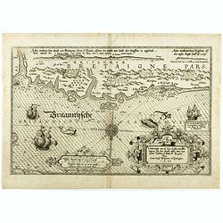
Verthoninghe van de Zee Custen van Bretaignen.
A very decorative chart covering the coast along the coast of Britany. South to the top. A first edition, without the privilege. Engraved by the master engraver, Johannes...
Place & Date: Amsterdam, 1596
Selling price: $1000
Sold in 2018
Artesia cuius incolae Atrebates. . .
A scarce copper engraved map of the Arras region of France by Matthias Quad, a German cartographer based in Cologne. Engraved by Johannes Bussemacher. The map shows the a...
Place & Date: Cologne, ca 1596
Selling price: $27
Sold in 2018
Burgundiae inferioris quae Ducatus Nomine Censetur, Des.
Centered on the province of Burgundy, from his 'Theatrum Orbis Terrarum'.
Place & Date: Antwerp 1598
Selling price: $335
Sold
Regionis Biturigum... Per Ioannem Calamaeum. / Limaniae Topographia Gabriele Symeoneo Auct.
Two maps on one sheet.
Place & Date: Antwerp 1598
Selling price: $180
Sold in 2009
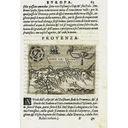
PROVENZA. GALLI NARBONESIS ORA MARITIMA RECETI
Rare copper-engraved miniature map by Giovanni Botero. Shows the Provence with North orientated to the bottom. Charming map with many place names. Decorated with a smal...
Place & Date: Venice, 1598
Selling price: $131
Sold in 2011
Andegavensium Ditionis Vera et Integra Descriptio.
A superbly engraved map of the area around Angers on the Loire exhibiting all the qualities for which Ortelius maps are renowened more that four hundred years after their...
Place & Date: Antwerp, 1598
Selling price: $280
Sold in 2013
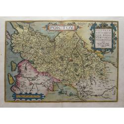
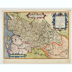
Poictou / Pictonum Vicinarum Que Regionum Fidiss Descriptio...
Beautiful old colored map of the Poitou in Western France by Abraham Ortelius. Showing the Atlantic coast with La Rochelle up to Limoges in the East. Includes the Loire r...
Place & Date: Antwerp, 1598
Selling price: $120
Sold in 2015
Burgundiae Comitatus Recentiss. Descriptio.
From 'Theatrum Orbis Terrarum [Atlas of the Whole World]'. Dare to go in Black. All early maps were printed in black and white, and many were kept that way for a long ...
Place & Date: Antwerp, 1598
Selling price: $75
Sold in 2022
Venuxini Comitatus Nova Descr. / Gallia Narbonensis. / Sabaudiae Ducat.
Three maps on one sheet. Upper left the coast of the Mediterranean Sea (with places like Narbonne, Aigues Mortes, Avignon, Arles etc. In the bottom left corner a map of t...
Place & Date: Antwerp, 1598
Selling price: $180
Sold in 2019
Poictou. Pictonum Vicinarum que Regionum Fidiss Descriptio.
Beautiful antique map of the former French province of Poitou, centered on the city of Poitiers.Reaching from the Atlantic to La Haye and Limoges and from Nantes to Cogna...
Place & Date: Antwerp, 1598
Selling price: $150
Sold in 2022
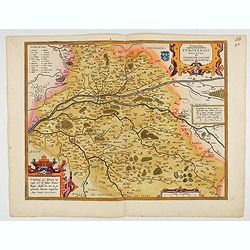
Touraine. Turonensis Ducatus.
Map of Touraine Duché in very fine original colours.
Place & Date: Antwerp, 1598

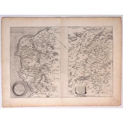
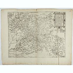
Regionis Biturigum... Per Ioannem Calamaeum. / Limaniae Topographia Gabriele Symeoneo Auct.
Two maps on one sheet. Biturigum. The Loire river is at the right in central France. Neuers (Nevers) is at the middle of the right margin. Bourges is near the center, an...
- $125 / ≈ €117
Place & Date: Antwerp, ca. 1598
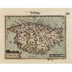
CORSICA.
A miniature map of Corsica.First published in 1598 in his Caert-Thresoor, the plates were executed by the most famous engravers in Amsterdam, including Petrus Kaerius and...
Place & Date: Amsterdam/Frankfurt 1599
Selling price: $170
Sold
Britannia & Normandia cum confinibs regionibus.
An important early map of Bretagne (Brittany) and Normandie, extending to show Paris, the Channel Islands, and parts of Cornwall. Decorated with sailing ships, a sea mons...
Place & Date: Duisburg or Amsterdam, ca. 1600
Selling price: $121
Sold in 2017
France Picardie Champaigne cum regionibus adiacentibus.
An early map of Bretagne (Brittany), Normandie, and Champagne. Extends from Arras to Auxerre and Orleans. Including Dieppe, Rouen, Paris, Verdun, towns are shown as small...
Place & Date: Amsterdam, ca 1600
Selling price: $14
Sold in 2018
Aquitania australis regnu Arelatense cum confinijs
Early map of southern France, extending until Monaco, parts of Spain and Switzerland. Published in Mercators famous Atlas Sive Cosmographia. Latin text on verso.
Place & Date: Amsterdam, ca. 1600
Selling price: $75
Sold in 2022
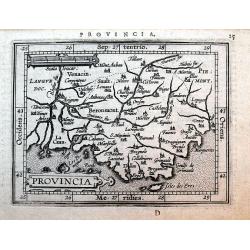
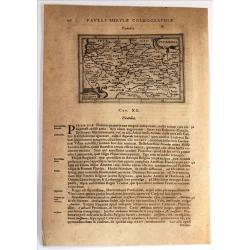
Provincia
Miniature map of Provence after Ortelius published by Giovanni Battista Vrients. Names the cities of Arles, Aix, Avignon, Marseille, Antibes, Toulon, and Nice. Decorated ...
Place & Date: Antwerp, ca. 1601
Selling price: $24
Sold in 2016
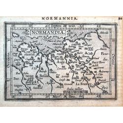
Normandia.
Miniature map of Normandy after Ortelius published by Giovanni Battista Vrients. Among many others it names the cities of Paris, Amiens, Dieppe, Caen, and Rouen. Decorate...
Place & Date: Antwerp, ca. 1601
Selling price: $110
Sold in 2016
Gallia Narbonens / Sabavdiae Ducat / Venuuxini comitatus Nova Descr.
Detailed maps of regions of southern and southeastern France by Ortelius. "Gallia Narbonens," the map on the top left, depicts the southern French Riviera coast...
Place & Date: Antwerp, 1603
Selling price: $124
Sold in 2010

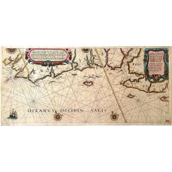
The sea coastes of the landes of Poyctou and Bordeaux ...as they shew and appeare, when you sayle there alongst betweene Picquelier and the River of Bordeaux called the Garonne
This particular chart is a fine example of the west coast of France including Isle de Re and Oléron. The nearby mainland displays La Rochelle and the town of Charente ne...
Place & Date: Amsterdam, 1588 - 1605
Selling price: $3700
Sold
Picardia.
From "Cosmographia Universalis" by Paul Merula, printed in Amsterdam in 1605. The maps used to illustrate the first edition of Cosmography were engraved in by J...
Place & Date: Amsterdam, 1605
Selling price: $32
Sold in 2019
Burgundia Ducatus.
One of the earliest maps of Burgundy.Mercator was born in Rupelmonde in Flanders and studied in Louvain under Gemma Frisius, Dutch writer, astronomer and mathematician. T...
Place & Date: Amsterdam 1606
Selling price: $200
Sold
L´Isle de France. Parisiesis Agri Descriptio..
Very detailed map of Isle de France, prepared by François de la Guillotiere. Centered on Paris and showing cities like Saint-Denis, Pontoise, Senlis, Meaux, etc. And dep...
Place & Date: Amsterdam 1606
Selling price: $170
Sold
Aquitania australis Regnu Arelatense cum consinijs.
Map of the southern part of France, centered on region of Auvergne, including Bourgogne, Provence, Limousine and Languedoc.Mercator was born in Rupelmonde in Flanders and...
Place & Date: Amsterdam 1606
Selling price: $140
Sold
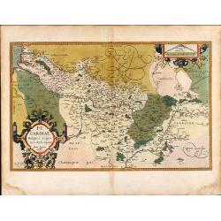
Berry ducatus.
Mercator/Hondius map of central France, shows city of Bourges. Accompanying text on verso.
Place & Date: Amsterdam, 1606
Selling price: $40
Sold in 2010
Berry ducatus.
Mercator/Hondius map of Loire Valley region of central France, of what was previously called the province of Berry. The city of Bourges, which was the capital of Berry, i...
Place & Date: Amsterdam, 1606
Selling price: $33
Sold in 2010
Britannia & Normandia cum consinib regionibus.
Map of Brittany and Normandy, including part of Picardy. Mercator was born in Rupelmonde in Flanders and studied in Louvain under Gemma Frisius, Dutch writer, astronomer ...
Place & Date: Amsterdam, 1606
Selling price: $170
Sold in 2016
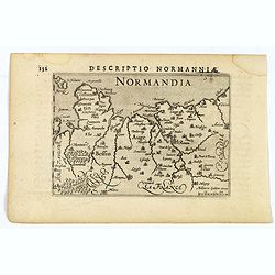
Descriptio Normanniae.
A charming small map of Normandy, showing Rouen ,Amiens, Cherbourg, Harfleur etc. From the Bertius atlas Tabularum geographicarum contractarum. Bertius (1565-1629) was a ...
Place & Date: Amsterdam, 1606
Selling price: $50
Sold in 2020
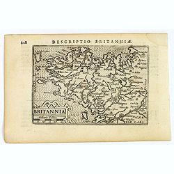
Descriptio Britanniae.
A charming small map of Britany in N.W. France. Showing Brest, St. Malo, Rennes, Nantes etc. From the Bertius atlas Tabularum geographicarum contractarum. Bertius (1565-1...
Place & Date: Amsterdam, 1606
Selling price: $50
Sold in 2021
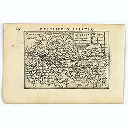
Descriptio Alsatiae.
A decorative miniature map of Alsace - a cultural and historical region in eastern France, on the west bank of the upper Rhine next to Germany and Switzerland. A map full...
Place & Date: Amsterdam, 1606
Selling price: $50
Sold in 2019
Lotharingia Meridiona.
Map depicting the southern part of the French region Lorraine. From the first French-text edition of Jodocus Hondius'' Atlas Minor.Shortly after the publication of the bi...
Place & Date: Amsterdam, 1608
Selling price: $80
Sold in 2011
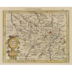
Burgundiae Duca.
Map depicting the French region Burgundy. From the first French-text edition of Jodocus Hondius'' Atlas Minor.Shortly after the publication of the big folio-atlases the n...
Place & Date: Amsterdam, 1608
Selling price: $50
Sold in 2008
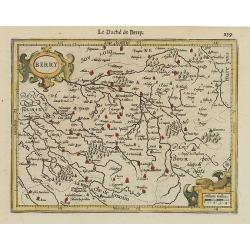
Berry.
Map centered on the French region Berry. From the first French-text edition of Jodocus Hondius' Atlas Minor.Shortly after the publication of the big folio-atlases the nee...
Place & Date: Amsterdam, 1608
Selling price: $80
Sold
Burgundiae Comitatus.
Map centered on the French region Franche-Comté, extending southwards as far as Lake Geneva.Oriented with West on top. From the first French-text edition of Jodocus Hond...
Place & Date: Amsterdam, 1608
Selling price: $80
Sold in 2013
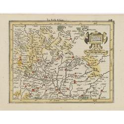
Alsatia Inferior.
Detailed map centered on Strasbourg, oriented with West on top. From the first French-text edition of Jodocus Hondius' Atlas Minor.Shortly after the publication of the bi...
Place & Date: Amsterdam, 1608
Selling price: $20
Sold in 2020
Eygentlijke afbeeldinge...Zee custen van Bretaigne Poictoi.
Very rare sea of the French coast of Brittany and Poictou, running from the Brest to the Loire and beyond. Title cartouche in both Dutch and French text. A beautiful and...
Place & Date: Amsterdam, ca. 1608
Selling price: $1600
Sold in 2011
Totius Lemovici et. . .
Map of part of France, centered on Limoge, including a plan of Limoge. Prepared by Jean du Fayen (1530-1612), French physician and geographer, who prepared the first know...
Place & Date: Amsterdam, 1608
Selling price: $50
Sold in 2016
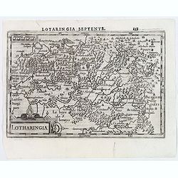
Lotharingia.
A nice small map centered on the French region of Lorraine, oriented with east on top. With some good map detail. From the Latin-text edition of Jodocus Hondius' Atlas Mi...
Place & Date: Amsterdam, 1608
Selling price: $25
Sold in 2020
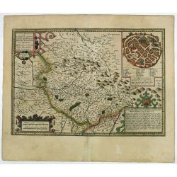
Totius Lemovici et . . .
Map of part of France, centered on Limoge, including a plan of Limoge. Prepared by Jean du Fayen (1530-1612), French physician and geographer, who prepared the first know...
Place & Date: Amsterdam, 1608
Selling price: $22
Sold in 2019
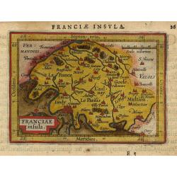
Franciae insula.
Miniature map of Paris area with major cities named, Paris is situated left under. Strapwork title cartouche in the left under corner. Latin text on verso.
Place & Date: Antwerp 1609
Selling price: $80
Sold
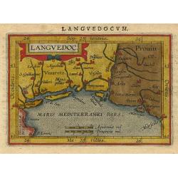
Languedoc.
Miniature map of Languedoc, South France with major cities named, Marseille is in the right border. Sea is stipple engraved. Strapwork title cartouche at the top. Latin t...
Place & Date: Antwerp 1609
Selling price: $76
Sold