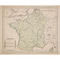
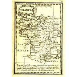
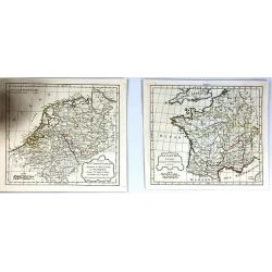
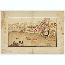
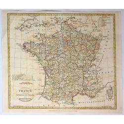
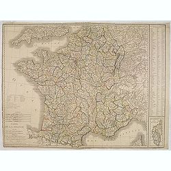
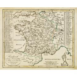
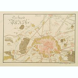
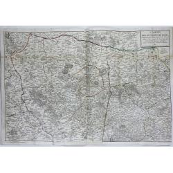
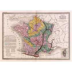
Das Heutige Frankreich.
Franz Johann Joseph von Reilly. He was active as an art dealer, publisher and mapmaker in Vienna. Issued in "Schauplatz der Welt".
Place & Date: Veinna 1791
Selling price: $20
Sold
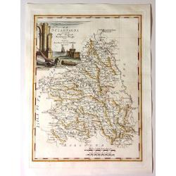
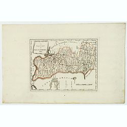
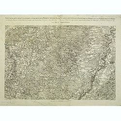
La Scampagna.
Fine map of “La Sciampagna" (Champagne) by Bartolammeo Borghi. Edited by Vincenzo Pazzini Carli and is from the atlas "Atlante Novissimo".Striking cartou...
Place & Date: Sienna, 1791
Selling price: $20
Sold in 2021
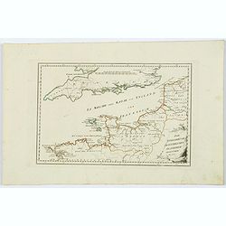
Die Englischekuste dem Nordlichen Frankreich.
Von Reilly's map of the English Channel, the Channel Islands, southern England and northern France. From the Atlas Schauplatz der funf Theile der Welt. With some coastal ...
Place & Date: Vienna, 1791
Selling price: $15
Sold in 2021
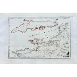
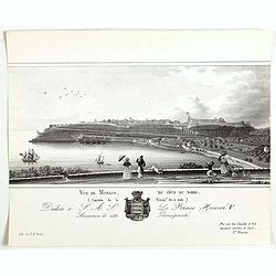
Die Englische Küste dem nördlichen Frankreich gegenüber.
Nice map of the Channel, including London, Ostende, the Channel Isles, and parts of the Bretagne.
Place & Date: Vienna, ca. 1791
Plan de la forest de Compiègne appartenante au Roy. . .
A very decorative and rareof Forest of Compiegne, in the Picardy reggion. Including a numbered key (A-Z and 1-10) in lower part. Engraved by Pierre-Alexandre Aveline. Wit...
Place & Date: Paris, ca.1792
Selling price: $150
Sold in 2013
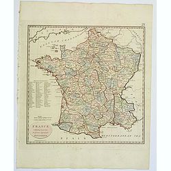
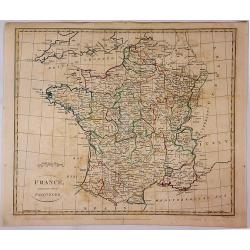
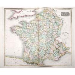
France.
Uncommon miniature map from Gibson's "Atlas Minimus, or a New Set of Pocket Maps of the several Empires, Kingdoms and States of the known World".
Place & Date: London, 1792
Selling price: $35
Sold
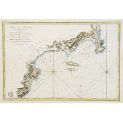
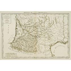
Côtes de France : Département du Var, comprenant le Golfe de la Napoule et le Gourjean. . .
Uncommon of part of the French Mediterranean seaboard centered on the Îles de Lérins and La Napoule gulf with Cannes and Nice. It covers the coast extending from the a...
Place & Date: Paris, 1792
Selling price: $400
Sold in 2011
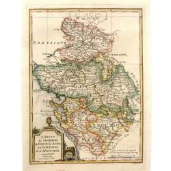
L'Anjou il Saumurois Il Poitou L'Aunis La Saintonge e L'Angoumois.
Copper engraving from the rare Geographical Atlas published in Siena by Pazzini Carli between 1798 and 1800, which can be considered a sort of dress rehearsal for the mos...
Place & Date: Florence, 1792
Selling price: $111
Sold in 2017
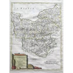
Normandia col Maine e Perche.
Unusual Italian map of Normandy - from Cherbourg to Le Tréport in the north and extending until Chartres, Laval, and Le Mans. With a large decorative title cartouche and...
Place & Date: Siena, 1792
Selling price: $6
Sold in 2016
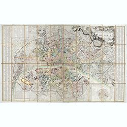
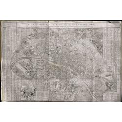
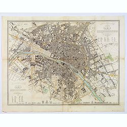
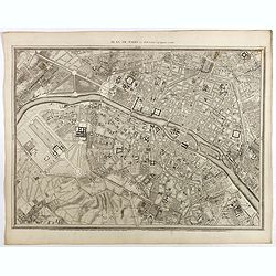
Nouveau plan routier de la ville et faubourgs de Paris Divisé en 48 sections d'après le Décret de l'Assemblée.
Beautiful plan of Paris in original colors. Second edition dated 1792 of five issues published between 1790 and 1797.Title cartouche decorated with a view of the Seine, a...
Place & Date: Paris, 1792
Selling price: $700
Sold in 2020
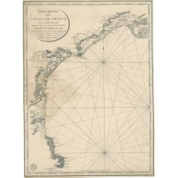
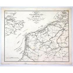
Cotes de France, départements du Pas de Calais et de la Somme
A large size sea chart of the French coast from Calais to the mouth of the Somme river. Full title at bottom right: 'Cotes de France, départements du Pas de Calais et de...
Place & Date: Paris, 1792
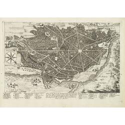
Pianta di Forti, e Trincieramenti Della Vitta di Tolone
A bird’s-eye view of the fort Toulon, France with the surrounding area. The map features the siege of Toulon which took place in 1793. After loyalist royalists had take...
Place & Date: Paris, 1793
Selling price: $20
Sold in 2016
(2 Maps) La Gaule & Partie de L'Empire Francais Royaumes de Hollande, de Westphalie, grand duche de Berg
Two maps of France at different times during their history. They are by Delamarche, the successor of Robert de Vaugondy.
Place & Date: Paris, 1794
Selling price: $15
Sold in 2017
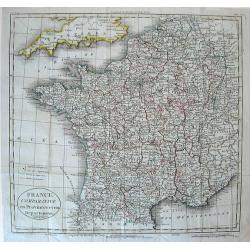
A New and Accurate Map of France, divided into Departments, Districts....
A fine map of France from Spencer's 'History of England'. The title cartouche features the French flag and a military helmet.There is an insert of the Island of Corsica.
Place & Date: London, 1794
Selling price: $15
Sold in 2016
A New & Accurate Map of France, Divided Into Departments, districts & c. as Decreed by the National Assembly.
A highly detailed map of France, published by John Cary, the founder of the famous English cartographic firm. Detail is copious and precisely delineated, including mounta...
Place & Date: London, 1794
Selling price: $30
Sold in 2019
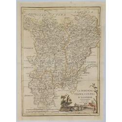
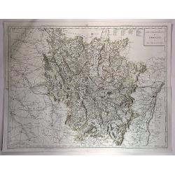
La Borgogna Franca Contea E Lionese.
A pleasant map of the Borgogna, Franca Contea and Lionese regions of France, by Carli Pazzini in Sienna in 1794. The map features a cartouche with a peasant leading cattl...
Place & Date: Siena, 1794
Selling price: $8
Sold in 2019
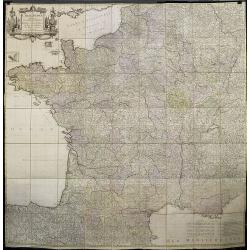
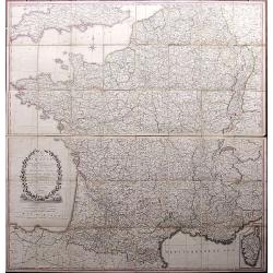
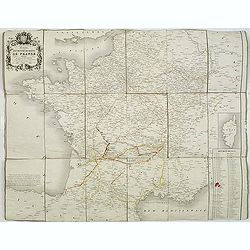
Carte de France divisée en LXXXIII departements Reduitte en neuf Feuilles égalles aux 24 Petittes de Illustre CASSINI. . .
Rare wall map of France published by Johann Michael Probst the younger (1757-1809). Prepared by Cassini.In 1747 Louis XV asked Caesar-Francois Cassini (Cassini III) to cr...
Place & Date: Augsburg, 1795
Selling price: $1050
Sold
Das Departement des Canals La Manche.
Manche is one of the original 83 departments created during the French Revolution on March 4, 1790. It was created from part of the province of Normandie. The first capit...
Place & Date: Vienna, ca 1795
Selling price: $15
Sold in 2021
Plan Geometral De Paris Et De Ses Fauxbourgs...
This exceptionally large, rare plan de Paris is a revision of De Vaugondy's smaller plan of 1783. This print was published by Delamarche who was the successor of Vaugondy...
Place & Date: Paris, 1797
Selling price: $290
Sold in 2019
France, exhibiting at one view its former & present Divisions.
A fully colored map of France from An Universal Atlas Consisting of a Complete Set of Maps, peculiarly adapted to illustrate and explain ancient and modern geography, S.J...
Place & Date: London, 1797
Selling price: $6
Sold in 2021
Piano di Nizza.
Rare 1797 manuscript map of Nice, with the French navy attacking from the sea. Unknown author, Italian, but map attributed to an original, probably broadsheet map by Moll...
Place & Date: Italy, after 1797
Specialkarte der Gegenden zwischen dem Rhein und der Saar. . . / Carte des pais situes entre le rhin et la sarre depuis spire. . .
Map of the frontier between Germany and France. Beautiful map showing the relief. Engraved by B.F. Leizelt.
Place & Date: Augsburg, 1798
Selling price: $75
Sold in 2014
France Divided Into Provinces.
A fine map of France with outline color delineating the provinces. Published in London in 1798 by G.G. & J Robinson, and engraved by S. Neele.
Place & Date: London, 1798
Selling price: $12
Sold in 2017
Gouvernements de Lorraine et Des Trois Eveches.
A large, detailed copper engraving map of the province of Lorraine, France by Mentelle and Chanlaire, from their "Atlas Universel". Published in Paris in 1798.
Place & Date: Paris, 1798
Selling price: $10
Sold in 2018
France Divided Into Metropolitan Circles and Departments.
A fine map of France divided into Metropolitan Circles and Departments by the English map publisher Clement Cruttwell. The French Department system was established in 179...
Place & Date: London, 1799
Selling price: $14
Sold in 2018
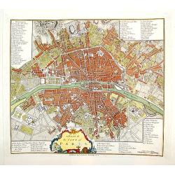
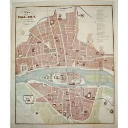
A Plan of the City of Paris.
A handsome and finely engraved plan of Paris based on late 18th century information. The work contains three legends identifying 78 points of interest, including major la...
Place & Date: London, dated 1800
Selling price: $340
Sold
Paris sous le regne de Louis XIII.
Unusual plan which shows Paris as it was in the beginning of the 17th century. A very detailed map, with street names, parks, places, hospitals, and important buildings s...
Place & Date: after 1800
Selling price: $50
Sold in 2016
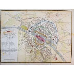
Plan de la ville de Paris dressé géométriquement d'après celui de la Grive, avec ses changements et augmentations.
Charming book forming a plan of Paris engraved by Perrier Oncle and written by Pelicier. Beautiful copy in very fresh colors.
Place & Date: Paris, 1803
Selling price: $1500
Sold in 2020
Carte de la France divisée en 108 departemens. . .
General map of France, showing a road-system and 108 departments. In lower right inset map of Corsica (140x70mm.) The map is dated 1804 and "An 12" being the 12...
Place & Date: Paris, An 12 / 1804
Selling price: $40
Sold

Vue du Pont des Arts.
Fine Vue Optique featuring the neighbourhood close to the Louvre. The bridge was the first iton bridge in Paris. Unlike most Vue Optique prints, the hand-coloring on this...
Place & Date: Paris, 1805
Selling price: $27
Sold in 2019
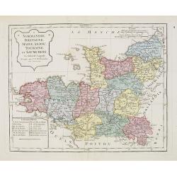
Normandie, Bretagne, Maine, Anjou, Tourraine, et Saumurois.
Map of Normandy, Brittany, Maine, Anjou, Tourraine, and the Saumur region. By C. F. Delamarche, successor of Robert de Vaugondy, Geographer. Inset lower left corner of t...
Place & Date: Paris, 1794 - 1806
Selling price: $50
Sold in 2008
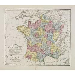
La France. . . .
Map of France. By C. F. Delamarche, successor of Robert de Vaugondy, Geographer.
Place & Date: Paris, 1806
Selling price: $30
Sold in 2008
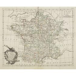
Carte du Royaume de France . . .
General map of France, from Atlas moderne portatif composé de vingt-huit cartes sur toutes les parties du globe terrestre .. A l'usage des Colléges, des Pensions & ...
Place & Date: Paris, Prudhomme, Levrault, Debray, 1806
Selling price: $40
Sold in 2009
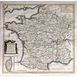
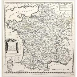
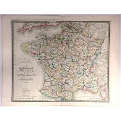
A Correct Map of France according to the New Divisions into Metropolitan Circles, Departments and Districts as decreed by the National Assembly, January 15th 1790 from a reduced copy of M. Cassini's large map...
A very large folding map of France with parts of England, the Benelux, Germany, Switzerland, Italy, and Spain. With an inset map of Corsica. Decorated with a large title ...
Place & Date: London, 1806
Selling price: $50
Sold in 2017
Frankreich nach dem Friedensschluss. . .
Nice small map of France published by Johannes Walch in his rare Allgemeiner Atlas Nach den bewährsten Hülfsmitteln und astronomischen Ortsbestimungen…, edition of 18...
Place & Date: Augsburg, 1812
Selling price: $60
Sold
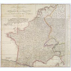
Kriegsschauplatz von ganz Frankreich und Holland.
Rare folding map map of France and the Low Countries published in the year of the defeat of Napoleon. Also including Switzerland and small part of Italy. In Italy the par...
Place & Date: Vienna, 1814
Selling price: $260
Sold in 2013
France
A beautiful map of France, engraved and published during Napoleon Bonaparte's time, with stunning color, and magnificent detail. Engraved by Hewitt.
Place & Date: London, ca 1814
Selling price: $12
Sold in 2016

Ceremony of Te Deum by the allied armies..
View of a military ceremony at the square Louis XV in Paris.
Place & Date: London 1815
Selling price: $160
Sold

PLAN DE LA VILLE DE PARIS, DIDIE ET PRESENTE AU ROI
A very large and exceedingly rare copperplate engraved plan of Paris with the River Seine at its center. An incredibly detailed work that identifies all streets, parks, g...
Place & Date: Paris, dated 1816
Selling price: $600
Sold
Die Gegend um Paris.
Very detailed manuscript plan in pen and ink with water color of Paris and it immediate environs. Singed with brown ink: "Christian Laugart (1)816 ".
Place & Date: Paris, 1816
Selling price: $300
Sold in 2008
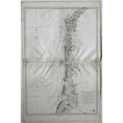
Carte réduite des côtes de France sur la Méditerranée
This masterful and attractive sea chart of the southern coast of France was created by order of the King of France for the Royal Nautical Depository (Dépôt), and bears ...
Place & Date: Paris, 1817
Selling price: $100
Sold in 2023
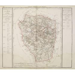
Departement de la Seine et de l'Oise.
Detailed map centered on Paris. Taken from "Atlas national de France", the first atlas with the departments of France published by Pierre Grégoire Chanlaire.
Place & Date: Paris, P.G. Chanlaire, 1818
Selling price: $60
Sold
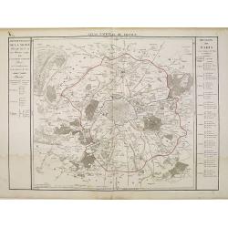
Departement de Paris en 12 Justices de Paix et 12 Maires.
Detailed map centered on Paris. Taken from "Atlas national de France", the first atlas with the departments of France published by Pierre Grégoire Chanlaire.
Place & Date: Paris, P.G. Chanlaire, 1818
Selling price: $120
Sold
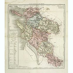
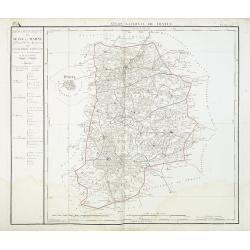
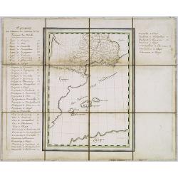
Département de la Charente inférieure decreté le 6 février 1790. . .
Map of region of west of France. Region of Charente inférieure divided into 7 districts. explicative text with the division of the districts and cantons.Sheet No. 38 fro...
Place & Date: Paris, 1790-1818
Selling price: $160
Sold
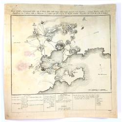
![Untitled. [Villefranche-sur-Mer]](/uploads/cache/90633-250x250.jpg)
Untitled. [Villefranche-sur-Mer]
Rare manuscript map of Villefranche-sur-Mer near Nice in southern France. Includes Mont Boron (here called Monboroni) and the peninsula of Saint-Jean-Cap-Ferrat. Finely e...
Place & Date: France, 1819
Selling price: $350
Sold in 2008
Carte de la Guienne, de la Navarre et du Bérn.
A detailed map of Guienne and Gascoigne. Engraved by Vallet.
Place & Date: Paris, 1820
Selling price: $74
Sold
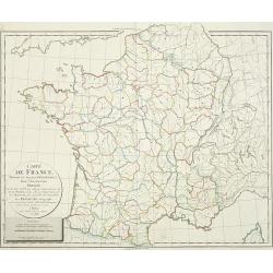
Carte de France.
Detailed map of France, with an updated date of "An 9" 1820 in the large allegoric title cartouche with a detailed title and dedication to the famous French car...
Place & Date: Paris, 1820
Selling price: $90
Sold

Vue du Palais de la Bourse.
Optical view of the stock exchange in Paris. In the eighteenth and nineteenth centuries there were many popular specialty establishments in Paris, Augsburg and London, wh...
Place & Date: Paris, ca. 1820
Selling price: $26
Sold in 2019
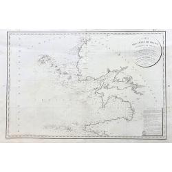
Carte D'Une Partie des Cotes de France.
Minimally detailed map of northern France and southeast Britain by Ambrose Tardieu from:"Precis des Evenements Militaires de plans et de Cartes". It shows Franc...
Place & Date: Paris , 1820
Selling price: $15
Sold in 2017
Carte des Environs de Paris.
A large, very detailed map of Paris and her surrounding area by Pichon (Ingeniur Geographe) and corrected by Amedee Martin. It was published by Chez Esnault in Paris in 1...
Place & Date: Paris, 1821
Selling price: $40
Sold in 2019
Cartes de France divisée en ses divers départemens,. . .
Map of France showing the different departments, all borders colored in outline.
Place & Date: Paris, 1823
Selling price: $60
Sold
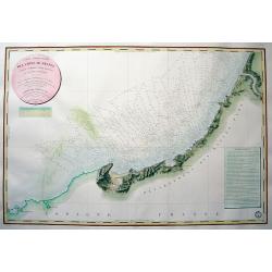
Carte des Cotes de France (environs de Brest) levee en 1816 1817 et 1818
A large sea-chart of the western parts of Finistère in the Bretagne, showing Ouessant, Brest, Plouguerneau, Crozon, Ile de Sein, and Audierne. With fantastic detail ...
Place & Date: Paris, 1823
Selling price: $150
Sold in 2023
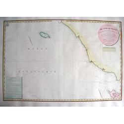
CARTE DES CÔTES DE FRANCE PARTIE COMPRISE ENTRE BAYONNE ET LA CÒTE D'ESPAGNE...
Highly decorative and scarce large-scale engraved seachart of the French and Spanish region at the Bay of Biscay / Coasts of Cantabria. Drawn by Besancon, engraved by Mic...
Place & Date: Paris, 1829
Selling price: $375
Sold in 2010
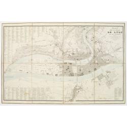
Plan de la Ville de Lyon, et ses environs, réduit d'apres les meilleurs levés, corrigé, augmenté et gravé d'après des plans particuliers et des reconoissances faites sur les lieux.
With the title at upper right, an alphabetical street index at upper left, an index of other features at lower left and right, and a scale of metres at lower right, the r...
Place & Date: Lyon, chez Midan libraire, 1830
Selling price: $200
Sold
CARTE DES CÔTES DE FRANCE PARTIE COMPRISE ENTRE L'ILE D'YEU ET LA POINTE DES BALEINES
Highly decorative and very rare large-scale engraved seachart of the French coast from Ile de Ré until Ile d'Yeu, engraved by Collin. Includes Jard, Les Sables D'Olonne,...
Place & Date: Paris, 1832
Selling price: $290
Sold in 2010
Departement de Seine et Marne. . .
Map centred of Rosoy and Fontainebleau. Borders of the district are colored. Map showing the city Nemours, Melun, Meaux, etc. In the left margin a cartouche with the list...
Place & Date: Paris, 1832
Selling price: $60
Sold
![[Title page] Nouvelle géographie et statistique de la France, Alger et la Belgique.](/uploads/cache/41675-250x250.jpg)
[Title page] Nouvelle géographie et statistique de la France, Alger et la Belgique.
Frontispiece with map of France with two sheets showing a mail exchanges between Henry and the rector, the prefect and the ministry of the public institution, plus a desc...
Place & Date: Paris, 1834
Selling price: $50
Sold in 2020
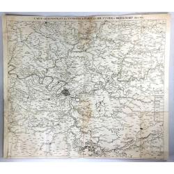
Carte Geognostique des Environs de Paris
A large detailed map from "Memoires de la Classe des Sciences Mathematiques et Physiques de l`Institut Imperial de France", by Cuvier & Brongniart, publishe...
Place & Date: Paris, 1835
Selling price: $21
Sold in 2016
Carte physique et minéralogique de la France.
Thematical map of France with inset map of Corsica and Paris.From Malte-Brun's Atlas Géographie Universelle.."., revised by Jean Jacques Nicolas Huot.This...
Place & Date: Paris 1837
Selling price: $20
Sold
Plan de la Ville de Paris, sous Phillipe de Bel...
An uncommon, large scale, decorative early 19th century plan of Paris. The work was commissioned by architect Albert Lenoir. Important buildings are highlighted and stree...
Place & Date: Paris, 1837
Selling price: $425
Sold
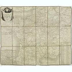
Carte des routes de poste de France dressée par Tardieu Graveur 1838.
This post road maps map of France is showing incredible detail of the postal roads, stations (or "stages"), and the distances from town to town. Lower left an i...
Place & Date: Paris, 1838
Selling price: $90
Sold
The Kingdom of France describing the New Limits according to the Treaty of Paris.
A large, beautifully detailed, and colorful map of France divided into 86 departments, with Corsica as an inset. No cartouche but very decorative calligraphy in the title...
Place & Date: London, 1838
Selling price: $16
Sold in 2016

Château de Rustephan. (Bretagne).
A view of the ruin of Rustephan Castle. Made "after nature" by Serda in 1837.
Place & Date: Paris, ca. 1840
Selling price: $20
Sold in 2009

Eglise et cimetière a St. Marc. (Bretagne).
A view of the cemetery of St. Marc in Bretagne. Made "after nature" by Serda in 1837. Lithographed by Vulleneuve.
Place & Date: Paris, ca. 1840
Selling price: $20
Sold in 2009
Vue de Monaco du côté du nord . . .
Extremely rare lithographed view of Monaco seen from the north side, lithographed by Jean Baptiste François Bosio, born June 17, 1764 in Monaco, and died July 6, 1827 in...
Place & Date: Monaco, 1841
Selling price: $1000
Sold
Western & Eastern Division Of Paris.
A detailed map of the French capital. Below it are 21 outlined perspectives of the iconic and important buildings and monuments within the city. Western and Eastern Quart...
Place & Date: London, 1842
Selling price: $65
Sold in 2018
Carte des routes de poste de France dressée par ordre de Mr Conte, Conseiler d'Etat Directeur de l'administration et Président du conseil des Postes.
This post road maps map of France is showing incredible detail of the postal roads, stations (or "stages"), and the distances from town to town. Lower right, a ...
Place & Date: Paris, 1843
Selling price: $180
Sold
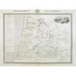
Département des Landes.
Detailed map of the Landes, with Bayonne in lower left corner. A panoramic view of Mont-de-Marsan upper right.. Text column of a detailed description of the geography, hi...
Place & Date: Paris, 1844
Selling price: $120
Sold
Plan de Paris Par Roussel Caqpt. Ingénieur en 1700.
Plan of the center of Paris by Claude Roussel (1655-172.?). here in a later reprint from around 1844.
Place & Date: Paris, after or ca. 1844
Selling price: $150
Sold
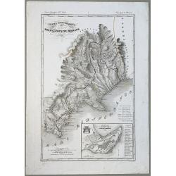
Carta Topografica del Principato Di Monaco.
A map of the Princedom of Monaco. Nice 19th Century map with insert at lower right: 'Topografia della Città Di Monaco', with legend 1-30. Original border-colored. From: ...
Place & Date: Florence, 1844
Selling price: $210
Sold in 2020
![[Fortifications de Paris.]](/uploads/cache/48146-250x250.jpg)
[Fortifications de Paris.]
A lovely quite detailed plan of Paris published towards the middle of the 19th century. The plan identifies the various fortifications that surrounded the city. They are ...
Place & Date: Paris, ca 1845
Selling price: $100
Sold in 2022
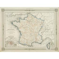
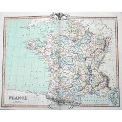
France par Provinces..
Fine map of France with inset plan of Paris at the year 1789, in lower right inset map of Corsica. Prepared by J.G.Barbié du Bocage. Published by Basset, rue de Seine 33...
Place & Date: Paris 1846
Selling price: $10
Sold
Manuscript map of the Southern Provinces of France.
Very detailed manuscript folding-map of the southern part of France. Including Lyon, Nice, Marseilles, Toulouse.Including the Balearic Islands of Majorca, Minorca, Ibiza....
Place & Date: France ca. 1850
Selling price: $475
Sold in 2020

Lot of 4 French Departements
Four very decorative engraved maps of the French Departements: Haut Rhin, Loire, Lozère, Doubs. Ornately decorated borders, vignette scenes, portraits and views of the r...
Place & Date: Paris, 1850
Selling price: $50
Sold

PARIS. Vue prise au dessus du Rond-Point des Champs-Elysées.
From Voyage aerien en France, L'Italie à vol d'oiseau. Made by Jules Arnout and printed by Lemercier. Published by A.Hauser. Bd. des Italiens.The publication is extrem...
Place & Date: Paris, c.1850
Selling price: $400
Sold
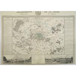
Departement de La Seine Environs de Paris.
A decorative 19th century map of the French department de La Seine with its capital Paris. The map is surrounded by two descriptive text panels to the left and right and ...
Place & Date: Paris, ca. 1850
Selling price: $300
Sold
France Comparative en Provinces et en Departements . . .
Map of France
Place & Date: France, c.1850
Selling price: $1
Sold in 2010
France
A fine map of France by George Frederick Cruchley. It covers all of France, seen here divided in its various departments. An inset shows the French island of Corsica. Ele...
Place & Date: London, 1850
Selling price: $12
Sold in 2016
![Dépt. Des Bes. Du Rhône. N°12. [ Marseille, Arles, Aix ]](/uploads/cache/27091-250x250.jpg)
Dépt. Des Bes. Du Rhône. N°12. [ Marseille, Arles, Aix ]
Map of the region around Marseille, Arles, Aix in the south of France.Lovely map from one of the last decorative atlases of the nineteenth century.The rather simple map i...
Place & Date: Paris, A. Combette, 1852
Selling price: $80
Sold in 2010
![Dépt. De La Charente. N°13. [ Cognac ]](/uploads/cache/27094-250x250.jpg)
Dépt. De La Charente. N°13. [ Cognac ]
Map of the Charente region, centered on Angouleme and Cognac. Home of the world's best-known brandy, the map shows the countryside surrounding the Charente River one hund...
Place & Date: Paris, A. Combette, 1852
Selling price: $50
Sold in 2023