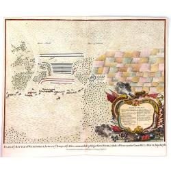
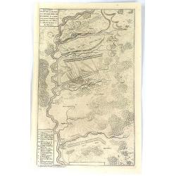
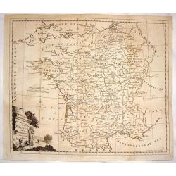
Plan of the Army of the Allies to Cover the Siege of Douay.
Fine detailed plan of the Siege of Douay in 1710. Copper engraving featuring the city of Douay and the Fort of Scarpe. Nicholas Tindal (1687-1774) / Paul de Rapin (1661-...
Place & Date: London, 1742
Selling price: $15
Sold in 2016
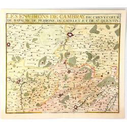
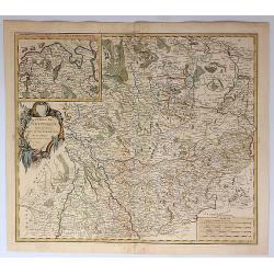
Les Environs de Cambray, de Crevecoeur, de Bapaume, De Perrone, Du Catelet de St. Quentin
A map showing the north part of France near Cambray on the Scheldt River, by Nicolas de Fer in Paris in 1724. It was published by Chez Le Benard.Nicolas de Fer (1646-172)...
Place & Date: Paris, 1743
Selling price: $17
Sold in 2019
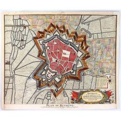
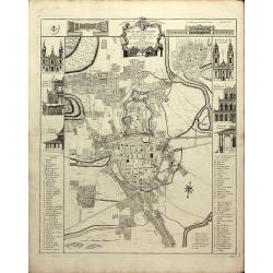
Plan of Bethune
An old detailed antique battle plan of Bethune in France showing the bastions, rivers, canals and fortifications outside the city and the shelling during the Spanish Succ...
Place & Date: London, 1743
Selling price: $39
Sold in 2016
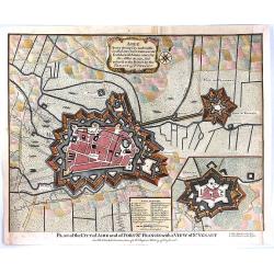
Plan of the City of Aire and of Fort St. Francis with a View of St. Venant
A very strong City and Castle in the Low Countries, in the Earldom of Artois, taken by the Allies in 1710, but restored to the French by the Treaty of Utrecht. The map is...
Place & Date: London, 1743
Selling price: $30
Sold in 2016
Plan of the Battle of Wynendal, Between the Troops of the Allies Commanded by Major Gen. Webb
A copper engraved battle plan between Major General Webb and Count de la Motte, with actual miniature pictures of the troupes. With a very fancy rococo cartouche, with ca...
Place & Date: Paris, 1743
Selling price: $30
Sold in 2016
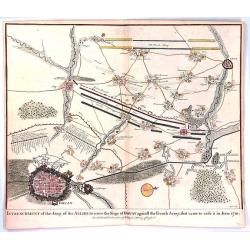
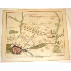
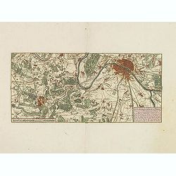
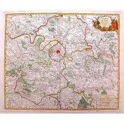
Entrenchment of the Army of the Allies to cover the Siege of Douay ...
An antique old battle plan of the fortified Town of Douai, France during the War of Spanish Succession (1701-1713) with surrounded area. The map shows the preparation of ...
Place & Date: London, 1743
Selling price: $41
Sold in 2016
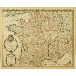
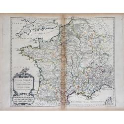
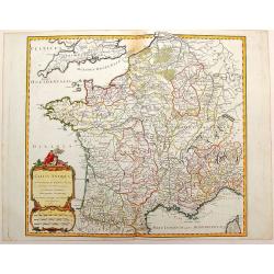
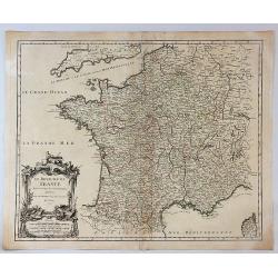
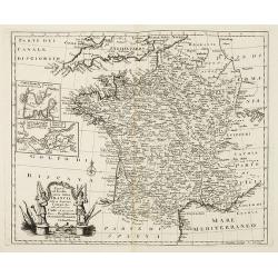
Nouvelle carte qui comprend les principaux Triangles qui servent de Fondement à la Description géométrique de la France. . .
Detailed map of France, showing city of Paris, Calais, Perigueux, Nantes, Marseille, Avignon, Reims…To the left and to the right 2 cartouches with the list of principal...
Place & Date: Paris, ca. 1744
Selling price: $450
Sold
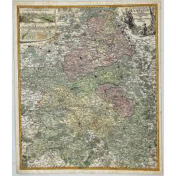
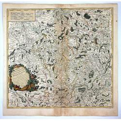
Partie Meridionale De Champagne. . .
Very detailed, topographical map of the southern Champagne. Showing fortified cities, roads, towns, rivers, lakes, forests, etc. The map is from a Dutch edition of De L'I...
Place & Date: Amsterdam c. 1745
Selling price: $180
Sold
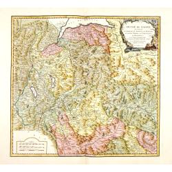
Le Gouvern.t Général du Dauphiné. . .
With decorative cartouche with dolphins.
Place & Date: Paris, 1745
Selling price: $350
Sold
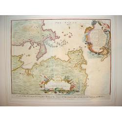
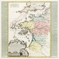
"Plan of Attack of Camaret Bay, on the Coast of Bretagne ..."
An interesting and attractive map of Camaret bay in Brittany. The piece depicts a battle scene between British and French naval forces in the vicinity of Brest.It feature...
Place & Date: London, ca 1745
Selling price: $200
Sold in 2008
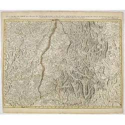
Le cours du Rhin de Bale à Hert près Philisbourg contenant L\'Alsace et partie du Brisgau..
The first map of the Rhine valley on such a large scale. To the lower left a scale cartouche and a small inset of Basle.With fine title cartouche upper rightLe Rouge (171...
Place & Date: Paris, 1745
Selling price: $325
Sold in 2008
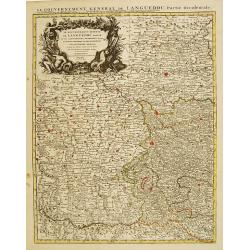
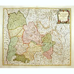
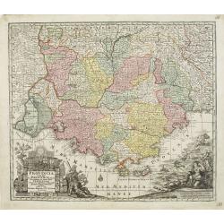
Le Gouvernement General de Languedoc Divisé..
Detailed map of the Southwest of France centred on Toulouse. The map is densely engraved with information with particular emphasis on the fortified cities, which are coll...
Place & Date: Amsterdam c. 1745
Selling price: $140
Sold
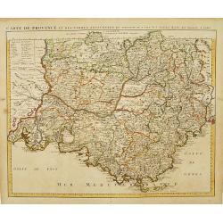
Carte de Provence et des Terres Adjacentes.
Topographically detailed map of the region of Provence in south-eastern France. Relief shown pictorially.The map is from a Dutch edition of De L'Isle's work entitled, Atl...
Place & Date: Amsterdam c. 1745
Selling price: $200
Sold
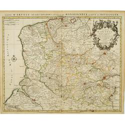
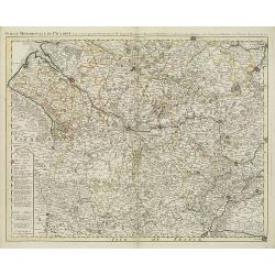
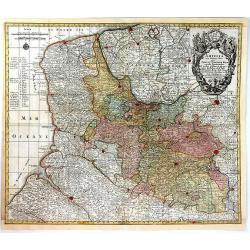
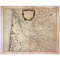
Carte D'Artois ET Des Environs..
Topographically detailed regional map of the Artois region in northern France. The map extends from Dunkirk and Abeville in the West to Doui, Cambrai and Lille in the Eas...
Place & Date: Amsterdam c. 1745
Selling price: $65
Sold
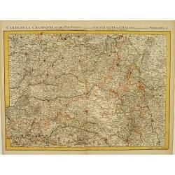
Carte De La Champagne et des Pays Voisins.. Chalons.. Soissons &c.
Very detailed, topographical map of Champagne and surrounding regions of Chalons and Soissons, Reims, Vedun, Mouzon, Sean, Charlemont, etc. Showing fortified cities, road...
Place & Date: Amsterdam c. 1745
Selling price: $135
Sold
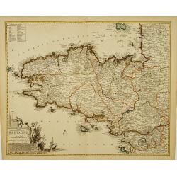
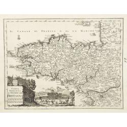
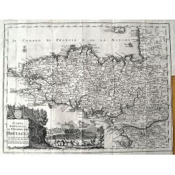
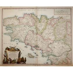
Duché et gouvernement General de Bretagne Divisé..
Highly detailed map of Brittany, in north-western France. Beautifully engraved with a decorative title cartouche depicting Poseidon and Hermes, a compass rose and table o...
Place & Date: Amsterdam c. 1745
Selling price: $265
Sold
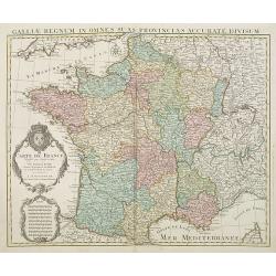
Carte De France Dressée pour l'usage du Roy..
Beautifully engraved, detailed general map of France, illustrating towns, roads, rivers, forests, etc. Embellished by 2 decorative cartouches: a title cartouche surmounte...
Place & Date: Amsterdam c. 1745
Selling price: $220
Sold
Le Cours du Rhin au dessus de Strasbourg et les Païs Adjacens.
Large, detailed map illustrating part of the flow of the river Rhine. It particularly depicts the stretch of river marking the natural border between Switzerland, France ...
Place & Date: Amsterdam c. 1745
Selling price: $50
Sold in 2016
![Carte du Bourdelois du Perigord.. [and] Carte Du Bearn de La Bigorre de L'Armagnac.. (2 sheets)](/uploads/cache/21538-250x250.jpg)
Carte du Bourdelois du Perigord.. [and] Carte Du Bearn de La Bigorre de L'Armagnac.. (2 sheets)
Large, detailed map of South-western France, encompassing the Aquitaine région (first sheet) and extending to the Spanish Border and Toulouse (second sheet).The map is f...
Place & Date: Amsterdam c. 1745
Selling price: $335
Sold
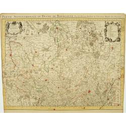
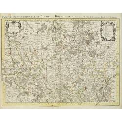
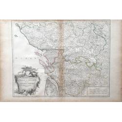
Partie Septentrionale du Duche de Bourgogne..
Large, detailed map of northern Burgundy, covering the region from Bar-sur-Seine in the North to Dijon and Auxonne in the South East. Shows illustrated topography with ma...
Place & Date: Amsterdam c. 1745
Selling price: $165
Sold
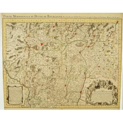
Partie Meridionale du Duche de Bourgogne..
Large, detailed map of northern Burgundy, covering the region from Autun and Dole in the North to Charolles and Mâcon in the South. Shows illustrated topography with man...
Place & Date: Amsterdam c. 1745
Selling price: $165
Sold

Vue du Château de Marli. Prise du bas du grand parterre. . .
A magnificent view of a stunning Château de Marli by the celebrated landscape engraver Jacques Rigaud (1681-1754). At the Château of Marly, Louis XIV of France escaped ...
Place & Date: Paris, c. 1745
Selling price: $300
Sold in 2009
Partie Septentrionale du Duche de Bourgogne . . .
Large, detailed map of northern Burgundy, covering the region from Bar-sur-Seine in the North to Dijon and Auxonne in the South East. Shows many villages, towns, roads an...
Place & Date: Amsterdam, ca. 1745
Selling price: $180
Sold
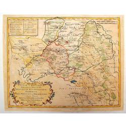
Partie meridionale de Picardie dressee sur les operations geometriques de Mrs. Lesperson & de Rousseville et sur plusieurs autres memoires Par Guillaume Del'isle . . .
Engraved map of the Picardie region in northern France. Urban areas in color. Relief is shown pictorially. Shows forests, Roman roads, churches, abbeys by religious order...
Place & Date: Amsterdam, 1745
Selling price: $135
Sold in 2009
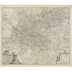
Gouvernement Général de L'Isle de France . . .
A fine engraved map centered on Paris metropolitan area and its vicinities in the Isle de France region. Decorative title and scale cartouches.The map is from a Dutch edi...
Place & Date: Paris, ca. 1745
Selling price: $400
Sold in 2012
Carte De France Dressée pour l'usage du Roy. . .
Beautifully engraved, detailed general map of France, illustrating towns, roads, rivers, forests, etc. Embellished by two decorative cartouches: a title cartouche surmoun...
Place & Date: Amsterdam, c. 1745
Selling price: $550
Sold
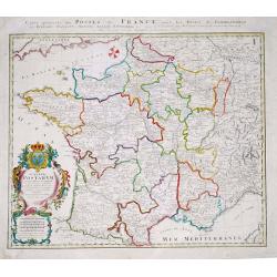
Gallia Postarum geografice designata.
Homann Heirs (of Johann Baptist and Johann Christof) published: Grosser Atlas, 1731, 1737. Geogr. Maior, 1759, Atlas Homannianus, 1762.Alexis Jaillot's map showing the po...
Place & Date: Nurnberg, 1745
Selling price: $90
Sold in 2019
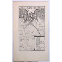
Plan de L'Attaque de St. Venant.
A striking example of Covens & Mortier's plan of St. Venant. The map focuses on the town fortifications and includes details of the town plan and environs. The primar...
Place & Date: Amsterdam, ca. 1745
Selling price: $16
Sold in 2019
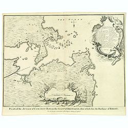
Plan of Attack of Camaret Bay, on the Coast of Bretagne. . .
An interesting and attractive map of Camaret bay in Brittany. The piece depicts a battle scene between British and French naval forces in the vicinity of Brest.It feature...
Place & Date: London, ca 1745
Selling price: $35
Sold in 2020
Partie Septentrionale du Duche de Bourgogne ...
Large, detailed map of northern Burgundy, covering the region from Bar-sur-Seine in the North to Dijon and Auxonne in the South East. Embellished with 2 cartouches both d...
Place & Date: Amsterdam, 1745
Selling price: $165
Sold in 2022
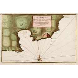
Plan de la Baye de Nagaye.
Prepared by Jacques Ayrouard and engraved by Louis Corne. Decorated with a large compass rose. From the rare chart book by Jacques Ayrouard: Recueil de plusieurs Ports .....
Place & Date: Marseille, 1732 - 1746
Selling price: $230
Sold
![[Untitled Front views of the coastal relief of Provence]](/uploads/cache/23302-250x250.jpg)
[Untitled Front views of the coastal relief of Provence]
Copper engraving presenting separate front views of the coastal relief of Provence divided in stripes.It covers the area which extends from Cap Sicié as far as Monaco, i...
Place & Date: Marseille, 1732 - 1746
Selling price: $140
Sold
![[Untitled] Front views of the Riviera.](/uploads/cache/24832-250x250.jpg)
[Untitled] Front views of the Riviera.
Copper engraving presenting separate front views of the Italian Riviera.It covers the whole Gulf of Genoa and Monaco.From the rare chart book by Jacques Ayrouard: Recueil...
Place & Date: Marseille, 1732 - 1746
Selling price: $85
Sold
![[Untitled] Front views of the coastal relief of Corsica and Tuscany.](/uploads/cache/24834-250x250.jpg)
[Untitled] Front views of the coastal relief of Corsica and Tuscany.
Copper engraving presenting separate front views of the coastal relief of northern Corsica and the facing Tuscan shores, divided in stripes.From the rare chart book by Ja...
Place & Date: Marseille, 1732 - 1746
Selling price: $55
Sold
![[Untitled] Front views of the coastal relief of the French Riviera.](/uploads/cache/24840-250x250.jpg)
[Untitled] Front views of the coastal relief of the French Riviera.
Separate front views depicting the coastal relief of French Riviera, divided in stripes.It covers the littoral zone between Monaco as far as the Iles Hyères.From the rar...
Place & Date: Marseille, 1732 - 1746
Selling price: $55
Sold
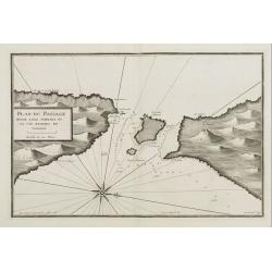
Plan du Passage Entre L isle Azinara et le Cap Azinara de Sardaigne.
Copper engraving depicting the northwestern tip of Sardinia and the southern tip of the Asinara Island.Oriented with West on top. Decorated with a large compass rose.From...
Place & Date: Marseille, 1732 - 1746
Selling price: $135
Sold
![[Untitled] Front views of the Italian coastal relief.](/uploads/cache/24848-250x250.jpg)
[Untitled] Front views of the Italian coastal relief.
Copper engraving presenting separate front views of the Tyrrhenian as well as Ionian coastal relief of Italy, divided in stripes.From the rare chart book by Jacques Ayrou...
Place & Date: Marseille 1732 - 1746
Selling price: $30
Sold
Totius Galliae sive Franciae tabula..
Johann Baptist Homann's well-engraved map of France has a large decorative cartouche and 12 coats of arms of different provinces. Detailed map centred on Venice. Johann B...
Place & Date: Nuremberg, 1747
Selling price: $540
Sold
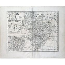
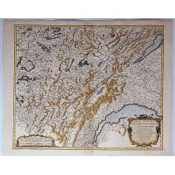
A New and Accurate Map of Savoy, Piemont, and Montferrat Exhibiting the Present Seat of War. . .
An attractive map of the Savoy and Montferrat regions of southeastern France and the northern Italian region of Piedmont on the Mediterranean Sea coast by Emmanuel Bowen...
Place & Date: London, 1747
Selling price: $50
Sold in 2010
Nouveau Plan de la Bataille Donnee Pres de Hochstet ....
The Battle of Blenheim (referred to in some countries as the Second Battle of Höchstädt), fought on 13 August 1704, was a major battle of the War of the Spanish Success...
Place & Date: Amsterdam, 1747
Selling price: $22
Sold in 2019
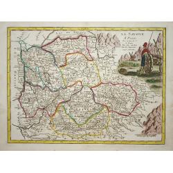
La savoye.
Nice map of the Savoie at the top the lake of Geneva and the Alps.
Place & Date: Paris 1748
Selling price: $80
Sold
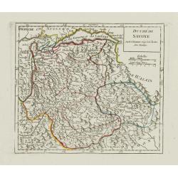
Duché de Savoye.
Detailed small map centered on Savoy, extending eastwards to include the Italian region Valle d'Aosta.From Atlas Portatif Universel, by Robert de Vaugondy. Page 53 outsid...
Place & Date: Paris, later than 1748
Selling price: $60
Sold in 2019
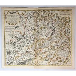
Partie Meridionale du Comte de Bourgogne ou Franche-Comte...
A striking map of the Burgundy (Bourgogne) and southern Franche-Comte region of eastern France by Robert de Vaugondy, published in 1749.It covers part of the southern Fra...
Place & Date: Paris, 1749
Selling price: $21
Sold in 2018
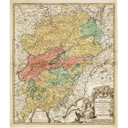
Partie Septentrionale du Comte de Bourgogne ou Franche Comte...
A striking, detailed map of the Burgundy and northern Franche-Comte region of eastern France by Robert de Vaugondy. It covers the modern day departments of Doubs, Haute-S...
Place & Date: Paris, 1749
Selling price: $15
Sold in 2018
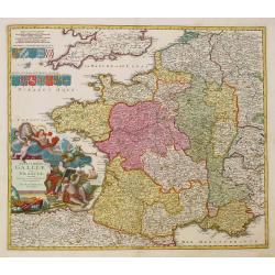
Carta geografica del governo della Bretagna. . .
From Volume II of Albrizzi's "Atlante Novissimo" after Guillaume de L'Isle. Showing Brittany divided into its Bishoprics and with all towns and cities marked, w...
Place & Date: Venise, 1750
Selling price: $180
Sold
Comitatus Burgundiae tam in primarias ejus ..
A good map of Burgundy orientated with north at the top. Decorative title cartouche with three figures, scale cartouche, coat of arms and putti holding grapes.Lower part ...
Place & Date: Augsburg 1750
Selling price: $160
Sold

Vue particulierie de Paris. Prise du Pont Royal regardant vers le Pont Neuf. Ou l''on voit les Galeries du Louvre et une partie des Thuilleries cs.
A beautiful optical view of Pont Neuf with the Louvre in Paris.
Place & Date: Paris, c. 1750
Selling price: $180
Sold in 2008
Brittische Übermacht Zur See wieder Franckreich..
Fascinating and finely engraved map engraved by M.A.Lotter and sold by his father, T.Lotter.It describes naval skirmishes between the British and French during the Seven ...
Place & Date: Paris 1750
Selling price: $450
Sold in 2010

Vue de l'Interieur de l Église Cathedrale de notre Dame de Paris.
An optical view of the interior of the Notre Dame in Paris.
Place & Date: Paris, c. 1750
Selling price: $100
Sold
Provincia Gallis la Provence dicta..
Seutter's well-engraved map has two large decorative cartouche. Including the towns of Marseille, Toulouse, St.Tropez, Cannes, Antibes, etc.
Place & Date: Nuremberg 1750
Selling price: $350
Sold
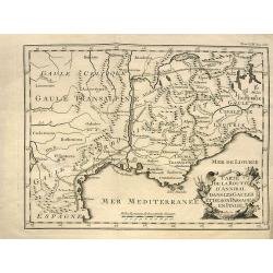
Carte de la route d'Annibal dans les Gaules et de son passage en Italie.
Interesting map showing the route of Hannibal. With south France and Liguria. After a map by Liebaux, a later edition probably from "Histoire Universelle".
Place & Date: Paris, c1750
Selling price: $15
Sold in 2013
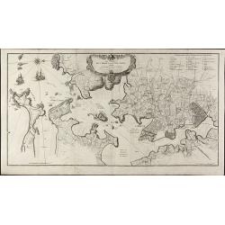
Les Environs de l'orient et du Port Louis. Dédiés à Monseigneur le comte d'Argençon Ministre et Secretaire d'Etat de la Guerre
A very large and rare map of Port Louis and Lorient by Le RougeThe copper engraved map published by G. L. le Rouge in 1750 and printed from two plate. It shows the area a...
Place & Date: Paris, 1750
Selling price: $950
Sold in 2010
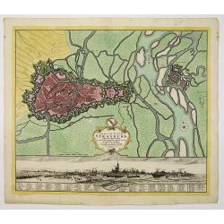
Stadt und Vestung Strasburg samt dem Fort Kehl.
Scarce decorative town-plan of Strasbourg with fine panoramic view of the city.
Place & Date: Nuremberg, 1750
Selling price: $200
Sold in 2011
Gallia Antiqua in Provincias et Populos divisa. . .
Large map of Ancient France, divided into provinces, published in de Vaugondy's Atlas Universal. Includes towns, mountains, rivers, lakes and other details. Decorative ti...
Place & Date: Paris, 1750
Selling price: $65
Sold in 2010
Carta Geografica del Governo della Bretagna.
Attractive and detailed map, showing Brittany divided into its bishoprics and with all towns and cities. Extending to Jersey. With a decorative title cartouche and a view...
Place & Date: Venice, c1750
Selling price: $48
Sold in 2011
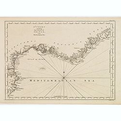
13th Chart including the coast of France, in the mediterranean sea.
Engraved chart of the coast of Provence and Languedoc, France, engraved by Thomas Jeffery's.
Place & Date: London, ca.1750
Selling price: $60
Sold
Gallia Antiqua in Provincias et Populos Divisa
This large map of the Roman time Gauls (Gallia) dated 1750, was incorporated in the 1st edition of "Atlas Universel" in 1757. With significant portions of Belgi...
Place & Date: Paris, 1750
Selling price: $41
Sold in 2015
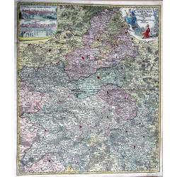
TABULA GEOGRAPHICA CAMPANIAE...
Decorative copper engraved map of Champagne. Very detailed, covering the region Champagne-Ardenne with Reims, Troyes, Châlons, Vitry, and Épernay. With an allegoric tit...
Place & Date: Nuremberg, 1750
Selling price: $59
Sold in 2013
Nieuwe kaart van Parys en Versailles met de nabygelegen Landstreek en Plaatsen.
Very detailed map covering the vicinity of Paris from Versailles to Vincennes. Nice detail around Boid de Boulogne and St.Cloud
Place & Date: Amsterdam, 1750
Selling price: $300
Sold in 2013

Vue Perspective de L'Interieur de L'Eglise des Invalides Prise Dessous les Orgues.
A Vue Optique featuring the interior of the Church of the Invalids in Paris. Jacques Chéreau (1688–1776) was a portrait engraver, printmaker and publisher of optical...
Place & Date: Paris, 1750
Selling price: $20
Sold in 2018

8e Vue d'optique nouvelle représentant la Foire St Ovide qui se tient dans la place Vendôme, à Paris.
Showing the St Ovide fair at the Vendôme Place in Paris. Likely published by J. Chereau, who was a well-known publisher of optical prints, established in rue St.Jacques ...
Place & Date: Paris, ca. 1750
Selling price: $100
Sold in 2015
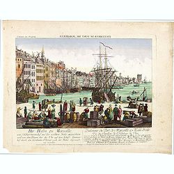
L'interieur du port de marseille...
A so-called optical print. A lively and harbor scene of Marseille, with many people loading a vessel. Engraved by Balthazar Frederic Leizelt.. The image is actually of a...
Place & Date: Augsburg, c. 1750
Selling price: $250
Sold in 2016
Artsia cum Finitimis Locis Seden ac Thatrum Belli ...
A fine large map of the Pas-de-Calais / Artois region in northern France, and part of Belgium between Calais, Abeville and Douay, with decorative figural cartouche. By Co...
Place & Date: Nüremburg, 1750
Selling price: $50
Sold in 2016
Le Royaume de France Divise Suivant les Gouvernemens Generaux.
A fine politically and topographically detailed 1750 map of France by Robert de Vaugondy. It covers all of France from the English Channel to Corsica and Spain.The map fe...
Place & Date: Paris, 1750
Selling price: $28
Sold in 2017
Tabula Geographica Campaniae in Suas Sic Dictas. . .
A map of Champagne, the famous wine provence in France. On the top left are insert views of Reims and Troyes, and a decorative cartouche featuring a king and his subjects...
Place & Date: Nuremberg, ca. 1750
Selling price: $22
Sold in 2018
Galliae Christianae Belgica Secunda Provinciae Ecclesiasticae Remensis
Nicely detailed copper engraved map covering the southwestern part of France. This map depicts the cities of Amiens, Senlis, Laon, Beauvais and Saint-Omer. Details includ...
Place & Date: Paris, 1751
Selling price: $21
Sold in 2014
Galliae Christianae Belgicae Secundae Ecclesiasticae Provinciae Remensis
Very large, decorative title cartouche on an interesting Nolin map of Reims, Amiens & Senlis France. Engraved on copper plates by Dussy.J. B. Nolin 1657-1708)set up h...
Place & Date: Paris, 1751
Selling price: $86
Sold in 2014
Duche de Savoye qui comprend le Chablais, le Fossigny, le Genevois, la Savoye Propre, la Tarentaise et la Maurienne, dresse d'apres la Grande Carte de Piemont de Tomaso Borgomo (i.e., Borgonio) et autres. . .
Finely and crisply engraved map of Savoy prepared by Robert de Vaugondy's map, from "Atlas Universel".Large decorative title cartouche in the upper right corner...
Place & Date: Venice, ca.,1751
Selling price: $480
Sold
Gouvernement General de Bretagne divife dioceses ou recceptes.
An attractive map of Brittany that extends to the island of Belle-Île, just off of the Quiberon Peninsula. The map shows the divisions of the dioceses and is filled with...
Place & Date: Paris, 1751
Selling price: $160
Sold in 2016
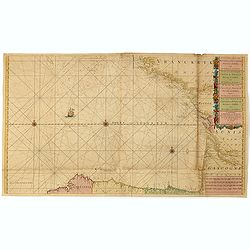
Nieuwe Generale Paskaart van de Bocht van Vrankryk Biscaia en Gallissia tussen I. de Ouessant en C. de Finisterre.
Rare chart of the Gulf of Biscay including all the south-west coast of France from Brest to the south and continuing along the Spanish coast, including Bilbao, until Ferr...
Place & Date: Amsterdam, 1728-1751
Selling price: $1350
Sold in 2015
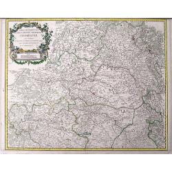
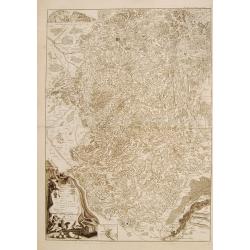
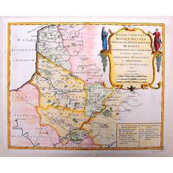
Partie septentrionale du Gouvernem? general de Champagne....
Very detailed map of the northern part of the famous Champagne region, centered on Reims. Includes towns, mountains, rivers, lakes, etc. With a large decorative title car...
Place & Date: Paris, ca. 1751
Selling price: $1
Sold in 2016
Cercle de Westphalie Divise en Tout Ses Etats et Souverainetes.
A fine map of Westphalia by Vaugondy in 1751. The Lower Rhenish–Westphalian Circle was an Imperial Circle of the Holy Roman Empire. It comprised territories of the form...
Place & Date: Paris, 1751
Selling price: $20
Sold in 2018
Plan de Nancy Avec les Changements que le Roy de Pologne Duc de Lorraine et de Bar a fait Dedié à sa Majesté Polonoise Par Le Rouge
A Rare plan of Nancy by Georges-Louis le RougeA large and detailed copper engraved plan of Nancy, published by le Rouge in 1752. Surrounded by important buildings of the ...
Place & Date: Paris, 1752
Selling price: $700
Sold in 2011
Nuova ed Esatta carta della Francia. . .
General map of France, after Emanuel Bowen, but from an Italian text edition. With an elegant baroque title cartouche. With inset charts of the harbors of Toulon & Br...
Place & Date: London, 1752
Selling price: $120
Sold
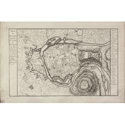
Plan de Besancon. Capitalle du Compté de Bourgogne.
A rare plan of Besancon in the Bourgogne by Le Rouge. Showing the fortified city with the adjacent streets, title to the left, and a keys to the right. We could not locat...
Place & Date: Paris, 1752
Selling price: $240
Sold
A New and Accurate Map of France with the Netherlands From the Best Authorities.
An interesting map featuring a rural cartouche with a woman holding a cross and looking at a papal crown and chalais laying on the ground. Emanuel Bowen (1714-1767), ma...
Place & Date: London, 1752
Selling price: $30
Sold in 2015
Partie Septentrionale du Gouvernement General de Bourgogne...
A detailed regional map with a large decorative Rococo cartouche. Shows fortified cities, towns, rivers, castles, churches, roads, woods, mountains, lakes, etc. It covers...
Place & Date: Paris , 1752
Selling price: $15
Sold in 2018
Partie Orientale du Gouvernement General de la Guienne...
A pleasing map of the Eastern Guyenne region of France by Vaugondy. It depicts the southern portion of France from Samatan east, to Bruide, and south as far as Toulouse, ...
Place & Date: Paris, 1752
Selling price: $20
Sold in 2019
Gouvernemens Generaux du Poitou, du Pays d'Aunis, et de Saintonge-Angoumois
Map of the Poitoi-Charentes region of France, along the central western coast, showing the cities of Rochefort, Poitiers, Niort and Saintes. Ornamental cartouche is in lo...
Place & Date: Paris: 1753
Selling price: $5
Sold in 2010
Environs de Paris
Detailed map of Paris and its surroundings with a decorative title cartouche and with cities, towns, forests. lakes, rivers & mountains clearly delineated. Gilles Rob...
Place & Date: Paris, 1753
Selling price: $71
Sold in 2014