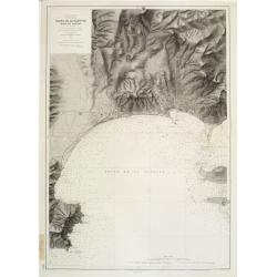
Mer Méditerranée - Côte de France - Golfe de la Napoule Rade de Cannes. . .
Large centered on the Gulf of La Napoule with the harbour of Cannes, the islands Sainte Marguerite and Saint Honorat on the right side. Showing towns, buildings, banks, ...
Place & Date: Paris, 1903 updated 1931
Selling price: $600
Sold
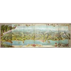
LA CÔTE D'AZUR.
Cover of an illustrated flyer. Printed by E.Imbert & Cie, Grasse -
Place & Date: Grasse, ca. 1935
Selling price: $325
Sold in 2020
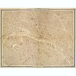
Plan de Paris à vol d'oiseau.
A very detailed plan of Paris for the year 1920. Design by Georges Peltier and published by Blondel la Rougery. Lower left "Ce plan dressé d'après nature est la pr...
Place & Date: Paris, Monroco, 1920-1940
Selling price: $180
Sold in 2013
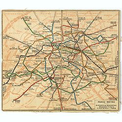
Plan de métro de Paris par Girard et Barrère. Edition de 1942
Miniature metro map of Paris, published by Girard et Barrère, Géographes - Editeurs, 17 rue de Buei, Paris.
Place & Date: Paris, 1942
Selling price: $10
Sold in 2020
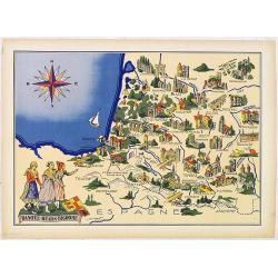
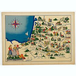
Basque - Bearn - Bigorre.
Very decorative, informative map of Basque - Bearn - Bigorre in south western France. Including the towns of Biarritz, Dax, Bayonne, Lourdes, etc. The map is filled with ...
Place & Date: France, 1943
Selling price: $90
Sold in 2013
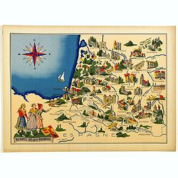
Basque - Bearn - Bigorre.
Very decorative, informative map of Basque - Bearn - Bigorre in south western France. Including the towns of Biarritz, Dax, Bayonne, Lourdes, etc. The map is filled with ...
Place & Date: France, 1943
Selling price: $65
Sold in 2014
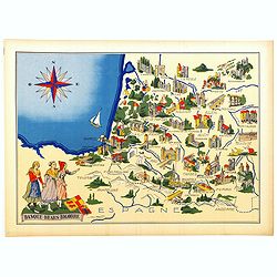
Basque - Bearn - Bigorre.
Very decorative, informative map of Basque - Bearn - Bigorre in south western France. Including the towns of Biarritz, Dax, Bayonne, Lourdes, etc. The map is filled with ...
Place & Date: France, 1943
Selling price: $60
Sold in 2016
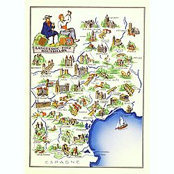
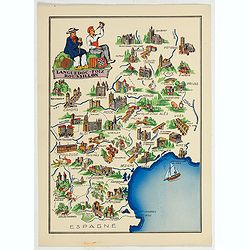
Languedoc - Foix Roussillon.
Very decorative, informative map of Languedoc - Foix Roussillon region in south eastern France. Including the towns of Carcassonne, Montpellier,, Albi, Toulouse, etc.The ...
Place & Date: France, 1943
Selling price: $95
Sold in 2016
Languedoc - Foix Roussillon.
This is a very decorative, informative map of the Languedoc - Foix Roussillon region in southeastern France, including the towns of Carcassonne, Montpellier,, Albi, Toulo...
Place & Date: France, 1943
Selling price: $40
Sold in 2023
Languedoc - Foix Roussillon.
Very decorative, informative map of Languedoc - Foix Roussillon region in south eastern France. Including the towns of Carcassonne, Montpellier,, Albi, Toulouse, etc.The ...
Place & Date: France, 1943
Selling price: $40
Sold in 2022
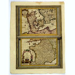
Le Danemarc. . . / La France. . .
A very nice pair of European maps, one the single plate by Pierre Van der Aa. Top map is that of Denmark, with grid lines, compass rose, mileage scales and a decorative t...
Place & Date: Leiden, 1713-29
Selling price: $60
Sold in 2019
Carte du Bearn de la Bigorre de l'Armagnac..
Map of south-west part of France covering the Landes country with Dax, Bayonne and Pau till Montauban and Toulouse on the right.
Place & Date: Paris [c. 1780]
Selling price: $120
Sold
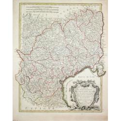
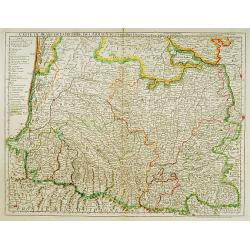
Carte des Gouvernements de Languedoc, de Foix et de Rousillon avec la Partie Oreintale du Gouvernement de Guienne.
Jean Lattré, Paris-based engraver and publisher. Worked with Robert de Vaugondy, J. Janvier and R. Bonne. " Atlas Monderne', 1771, 1783 , 1793. Rigobert Bonne (1727...
Place & Date: Paris, 1783.
Selling price: $120
Sold