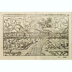
Selestat ou Schletstat, cité impériale, située au milieu du pays d'Alsace. . .
Panoramic of Sélestat in the French Alsace region. In lower right corner: RMD [Rudoplh Manuel called Deutsch who was a well-known wood-cutter].Taken from Sebastian Mün...
Place & Date: Basle, ca. 1560
Selling price: $80
Sold in 2014
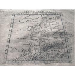
Tabula Europae III.
Ptolemaic style map of France, the Low Countries, and the Rhine river. Includes numerous historic place names. Italian text on verso.
Place & Date: Venice, c1561
Selling price: $54
Sold in 2013
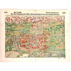
Rubeaquum Rusach (Château D'Isenbourg)
Rubeaquum Rufach is a detailed woodcut by Sebastian Münster showing the famous Château D'Isenbourg located in the heart of the vineyards on the Alsace wine route and th...
Place & Date: Basil, 1564
Selling price: $30
Sold in 2018
![[De Galliae et eius fitu, item de eius patitione . . . . . . ]](/uploads/cache/38525-250x250.jpg)
[De Galliae et eius fitu, item de eius patitione . . . . . . ]
One text page with a map of France on the recto (7,8 x 13,5 cm). On verso, a text page in one hand , and in the other a horn from Münster's Cosmographia Universalis.The ...
Place & Date: Basle, ca. 1564
Selling price: $25
Sold in 2018
![[De Regionibus, Ubibus et Fluviis Galliae . . . ]](/uploads/cache/38524-250x250.jpg)
[De Regionibus, Ubibus et Fluviis Galliae . . . ]
One text page with a map of Europe on the recto (12,2 x 15,5 cm). From Münster's Cosmographia Universalis.The Cosmographia by Sebastian Munster from 1544 is the earliest...
Place & Date: Basle, ca. 1564
Selling price: $25
Sold in 2022
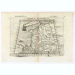
Tabula Europae III (France)
Early map of France. Girolamo Ruscelli first published the map in his "La Geographi di Claudio Tolomeo" (Venice, 1561). In 1574 a new plate was used which laste...
Place & Date: Venice, 1564
Selling price: $60
Sold in 2020
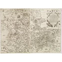
Galliae exactissima descriptio.
A unique opportunity to acquire a fine example from a map from the early Lafreri school. It was the custom for Italian map sellers to bind together available maps into a ...
Place & Date: Venice, 1566
Selling price: $4500
Sold
![CHALES [Calais]](/uploads/cache/38742-250x250.jpg)
CHALES [Calais]
Rare Lafreri School town-plan of Calais, engraved by Paolo Forlani, of the Lafreri school of mapmakers, first published in "Il Primo Libro Delle Citta, Et Fortezze P...
Place & Date: Venice, Zaltieri, (1567) 1567
Selling price: $60
Sold in 2018
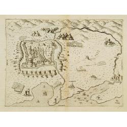
Perpignan.
Extremely rare panoramic view showing the siege of the town of Perpignan in 1595. Also showing the towns of Narbonne, Rivesaltes along with the Mediterranean coast.Engrav...
Place & Date: Venice 1568
Selling price: $300
Sold
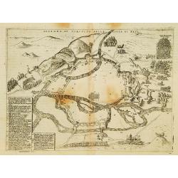
Desegno et circutio della citta di Metz.
Extremely rare panoramic view showing a plan of the siege of the town of Metz. In bottom left a numbered key 1-53. Engraved by Paolo Furlani (active 1561-1577), his addre...
Place & Date: Venice 1568
Selling price: $300
Sold