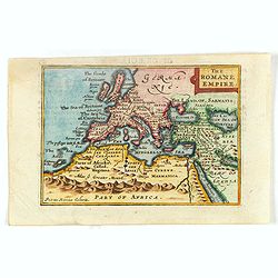
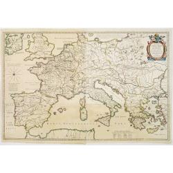
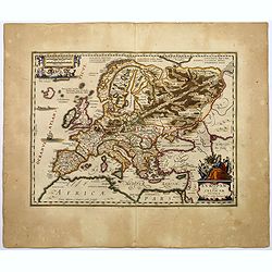
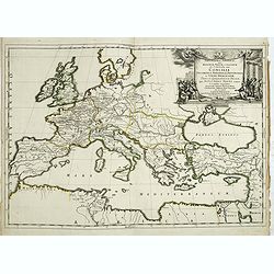
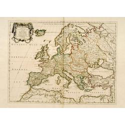
The Romane Empire.
Miniature map of the Roman Empire. The Roman Empire, at its height (c. 117 CE), was the most extensive political and social structure in western civilization.Kaerius (cir...
Place & Date: London, 1646
Selling price: $50
Sold in 2016
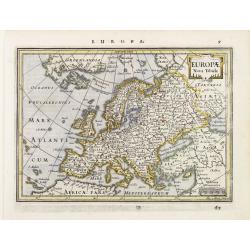
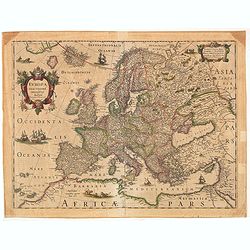
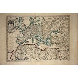
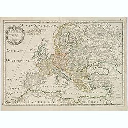
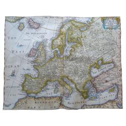
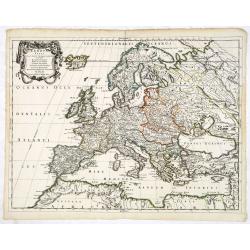
Europae Nova Tabula.
Detailed miniature map of Europe, from a German text edition of his Atlas Minor. Engraved by A. Goos.
Place & Date: Amsterdam (1628) 1648
Selling price: $110
Sold
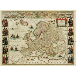
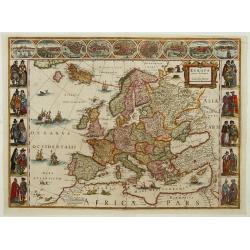
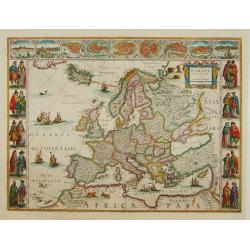
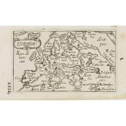
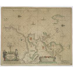
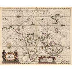
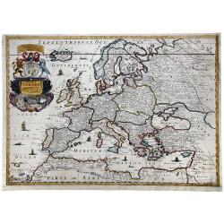
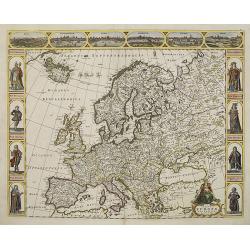
Europa recens descripta.
On either side columns depicting the manner of dress in the major countries of Europe, surmounted by nine city views and plans. For European mapmakers their own continent...
Place & Date: Amsterdam 1649
Selling price: $4685
Sold
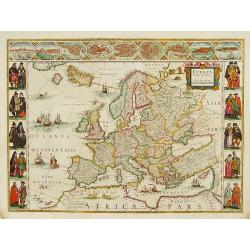
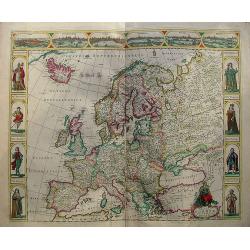
Europa recens descripta.
On either side columns depicting the manner of dress in the major countries of Europe, surmounted by nine city views and plans. For European mapmakers their own continent...
Place & Date: Amsterdam 1649
Selling price: $4225
Sold
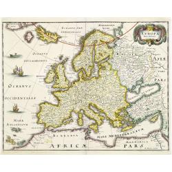
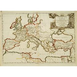
Europa exactissime descripta.
Embellished with two cartouches, several ships and a sea-monster, polar bears and lions. Now with the imprint of Henricus Hondius and the date 1631. With Dutch text on ve...
Place & Date: Amsterdam, 1631-1649
Selling price: $250
Sold in 2019
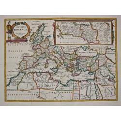
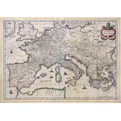
Imperium Romanum. Auth. Phil. Briet e Societ Iesu.
Philip Briet S.J. (1601-1668). French cartographer. Parallela Geogr. Veterus et Novae 1648, Atlas 1653.A map depicting the Roman Empire with an inset showing Rome and its...
Place & Date: Paris, c. 1650
Selling price: $200
Sold
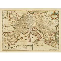
Imperium Caroli Magni
Finely engraved map of the Empire of Karol the Great.
Place & Date: Amsterdam 1650
Selling price: $320
Sold
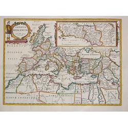
Imperium Romanum. Auth. Phil. Briet e Societ Iesu.
Philip Briet S.J. (1601-1668). French cartographer. Parallela Geogr. Veterus et Novae 1648, Atlas 1653.A map depicting the Roman Empire with an inset showing Rome and its...
Place & Date: Paris, c. 1650
Selling price: $275
Sold
Imperii Caroli Magni.
Prepared by Petrus Bertius in 1616. Very large historical map (four sheets joined) depicting the empire of Charles the Great. Fully engraved with mountains, forests, and ...
Place & Date: Amsterdam 1650
Selling price: $500
Sold
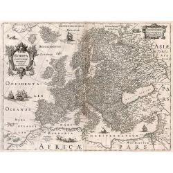
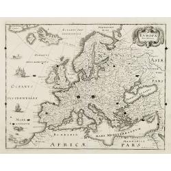
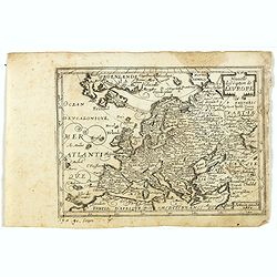
Europa Antiqua cum finitimis Africae & utriusque Asiae regionibus Nicolaus Blancardus Belga, Leidensis, Illustrium Comitatus Zelandiae Ordinum Historicus, ad lucem aevi veteris delineabat.
An uncommon map of Europe prepared by Nicolas Blankaart , extending to the Middle East and the northern tip of Africa, as it was during the time of the Roman Empire. The ...
Place & Date: Amsterdam, 1650
Selling price: $400
Sold in 2009
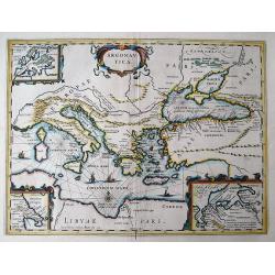
ARGONAUTICA
This decorative map illustrates the geography of the Golden Fleece legend in the Mediterranean, covering from Italy to the Black Sea. The Argonautica is a Greek epic poem...
Place & Date: Amsterdam, c1650
Selling price: $300
Sold in 2011
Imperium Caroli Magni.
Nice large map showing the Empire of Karol the Great.
Place & Date: Amsterdam, 1650
Selling price: $260
Sold in 2017
Europam, sive Celticam Veterem.
A map of the Celtic Empire by A. Ortelius, and reissued by Jansson in the middle of the seventeenth century. Ortelius' map first appeared in 1595.The map shows the contin...
Place & Date: Amsterdam, ca 1650
Selling price: $190
Sold in 2017
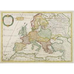
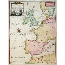
L'Europe. Par le S. Sanson d'Abbeville.
Fine map of Europe, with address of Pierre Mariette: rue st.Jacques a L'Esperance .Nicolas Sanson was to bring about the rise of French cartography, although the fierce c...
Place & Date: Paris, 1651
Selling price: $325
Sold in 2013
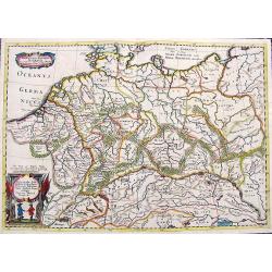
Germania Antiqua Australis...
A scarce map of central Europe with the ancient place names. Extends from modern day France until Poland, and from Denmark until Switzerland. Includes two decorative titl...
Place & Date: Unknown, ca. 1652
Selling price: $120
Sold in 2018
Europa exactissime descripta.
A fine map, embellished with two cartouches, several ships and a sea-monster, polar bears and lions. With French text on verso.
Place & Date: Amsterdam, 1652
Selling price: $100
Sold in 2017
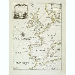
L'Europe
Fine map of Europe, with address of Pierre Mariette: rue st.Jacques a L'Esperance .Nicolas Sanson was to bring about the rise of French cartography, although the fierce c...
Place & Date: Paris, 1650-1659
Selling price: $275
Sold in 2011
Europa recens descripta a Guilielmo Blaeuw.
On either side columns depicting the manner of dress in the major countries of Europe, surmounted by nine city views and plans. For European mapmakers their own continent...
Place & Date: Amsterdam, 1660
Selling price: $2400
Sold
Europa recens descripta a Guilielmo Blaeuw.
On either side columns depicting the manner of dress in the major countries of Europe, surmounted by nine city views and plans. For European mapmakers their own continent...
Place & Date: Amsterdam 1660
Selling price: $2000
Sold
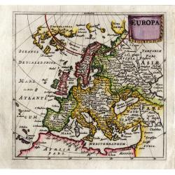
EUROPA Nova delineatio.
Decorative map of Europe, after Blaeu, depicting the mythical island of Friesland.
Place & Date: Frankfurt, 1660
Selling price: $160
Sold in 2011
EUROPA Nova delineatio.
Decorative map of Europe, after Blaeu, depicting the mythical island of Friesland.
Place & Date: Frankfurt, 1660
Selling price: $100
Sold in 2008
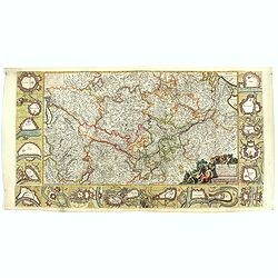
Fluviorum Rheni Mosae Mosellae Moeni Neccaris aliorumque minorum in eosdem se exonerantium et regionum circumjacentium descriptio
Fluviorum Rheni Mosae Mosellae Moeni Neccaris aliorumque minorum in eosdem se exonerantium et regionum circumjacentium descriptio Decorative map with 18 vignettes on thr...
- $750 / ≈ €702
Place & Date: Amsterdam, ca. 1660
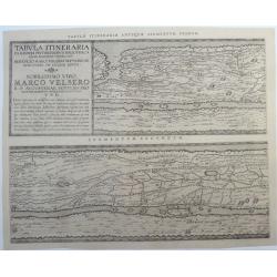
Tabula Itineraria Ex Illustri Peutingerorum. (the two Western-European segments only, Segmentum Primum, and Segmentum Secundum.)
A rare and famous map from the Peutinger Table comprising Western-Europe. Twee parts of eight only. The ancient roadmap depicts the imperial roads and posts within the Ro...
Place & Date: Amsterdam, ca. 1662
Selling price: $600
Sold in 2020
Europa.
Charming little map of Europe made by Gabriel Bucelin (1599-1681). Bucelin was a Swiss genealogist and an author of several books and a number of manuscript maps of Germa...
Place & Date: Ulm, Johannes Görlin, 1658-1664
Selling price: $190
Sold in 2008
Pascaart van Europa alsmede een gedeelte vande Kust van Africa. . .
An eye-catching chart of the entirety of Europe's coastline from northern Russia to Yugoslavia in the south. Also showing the West Coast of Africa as far as the Cape-Verd...
Place & Date: Amsterdam, after 1666
Selling price: $900
Sold in 2011
L'Ocean Pres D'Europe Avec Les Costes De France, d'Espagne, de Portugal, d'Angleterre, de Holande, De Danemarc Etc. Suivant Les Costes Marines Les Plus Nouvelles. Par. P. Du Val, Geogr.du Roy. 1666.
Attractive chart by Pierre Du Val shows the North Atlantic Ocean & the coast of Europe from Scandinavia & Great Britain down to France, Spain, the Mediterranean &...
Place & Date: Paris, 1666
Selling price: $400
Sold in 2011
L'Ocean près d'Europe avec les Costes de France, d'Espagne, de Portugal, d'Angleterre, de Hollande, de Danemarc, & cie . . .
Attractive chart by Pierre Du Val shows the North Atlantic Ocean and the coast of Europe from Scandinavia and Great Britain down to France, Spain, the Mediterranean and N...
Place & Date: Paris, 1666
Selling price: $300
Sold
Geographia Synodica, Sive Regionum, Vrbium, et Locorum vbi Celebrata Sunt Concilia Oecumenica, Nationalia, Provincialia et Synodi Dioecesanae
Attractive historical map of Europe, the Mediterranean, and northern Africa. Extends to Cyprus and the Holy Land. Based on the cartography of Guillaume Samson and publish...
Place & Date: Paris, 1666
Selling price: $75
Sold in 2020
Geographia Synodica, Sive Regionum, Vrbium, et Locorum vbi Celebrata Sunt Concilia Oecumenica, Nationalia, Provincialia et Synodi Dioecesanae
Attractive historical map of Europe, the Mediterranean, and northern Africa. Extends to Cyprus and the Holy Land. Based on the cartography of Guillaume Samson and publish...
Place & Date: Paris, 1666
Selling price: $100
Sold in 2016
Europae Descriptio Nova…Philippi Chetwind 1666
Very decorative map w. innumerable topographical names, two sea monsters and a sailing ship, and with a long wall in Russia "for resistance of ye violent intrusion o...
Place & Date: London, P. Chetwind, 1666
Pascaart van Europa, Als mede een gedeelt vande cust von Africa.
This is a superb example of Pieter Goos's nautical chart of the Atlantic and Mediterranean detailing coastal ports and cities of West Africa, the Canary Islands, Europe, ...
Place & Date: Amsterdam, 1666
Nouvelle description de l'Europe.
Rare map of Europe with an oversized Iceland, published by Jollain in 1667. Published in "Trésor Des Cartes Geographiques Des Principaux Estats de Lunivers".Th...
Place & Date: Paris, 1667
Selling price: $200
Sold in 2019
Europa Vetus.
A fine map of the ancient European continent.This edition carries the date 1668.Nicolas Sanson was to bring about the rise of French cartography, although the fierce comp...
Place & Date: Paris, 1668
Selling price: $280
Sold
Europa Vetus.
Attractive historical map of Europe, the Mediterranean, and northern Africa. Extends to Cyprus and the Holy Land. Based on the cartography of Guillaume Samson and publish...
Place & Date: Paris, 1668
Selling price: $135
Sold in 2013
A MAPP OF EUROPE.
A fine example of Blome's scarce map of Europe, the earliest folio size map of Europe to be engraved and printed in England. The map demonstrates the naïve engraving sty...
Place & Date: London, 1669
Selling price: $300
Sold in 2020
Concilia Oeucumenica Nationalia Provincialia ..
A fine map of Europe and Near East, depicting a geographic representations of Church history.Prepared by Guillaume Sanson (1633-1703), the son of Nicolas Sanson.Published...
Place & Date: Paris 1670
Selling price: $92
Sold
Nova europae descriptio.
An attractive carte à figures map of the European continent. In the top there are six views of : Rome, Amsterdam, Paris, London, Seville and Prague. At both sides there ...
Place & Date: Amsterdam, 1670
Selling price: $2200
Sold in 2011
Nova europae descriptio.
An attracting "carte à figures" map of the European continent. In the top there are six views of: Roma, Amsterodamum, Paris, Londinum, Sivilla and Praga. At bo...
Place & Date: Amsterdam, 1670
Selling price: $1800
Sold in 2010
Europa (heightened with gold leaf)
From a copy of "Introductionis in Universam Geographicam". Published by Bertius in Amsterdam and printed on the Elzevier press. Beautiful map in period correct ...
Place & Date: Amsterdam, ca. 1672
Selling price: $150
Sold
Concilia Oeucumenica Nationalia Provincialia ..
A fine map of Europe, depicting a geographic representations of Church history.This edition has the original address of the publisher Apud Petrum Mariette Via Jacoba sub ...
Place & Date: Paris, after 1674
Selling price: $122
Sold