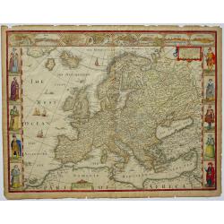
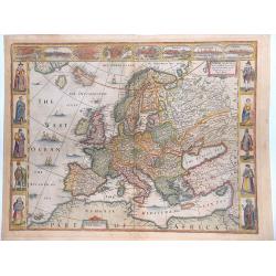
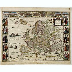
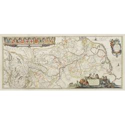
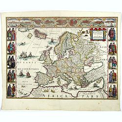
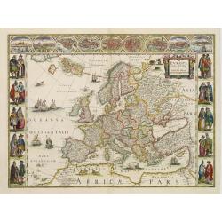
Europ, and the cheife Cities contained therein, described with the habits of most Kingdoms now in use... 1626.
A very decorative and prestigious “carte à figures”- map. Map is bordered by images of various European ethnicities in traditional 17th century dress. The upper bord...
Place & Date: London, 1626
Selling price: $2000
Sold in 2018
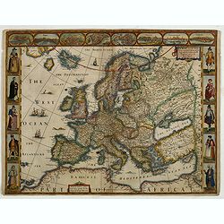
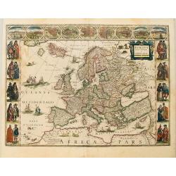
Evrop, and the cheife Cities contayned therin ...1626.
A landmark English map of Europe being the First English Map Of Europe.
Place & Date: London, 1626
Selling price: $1101
Sold in 2019
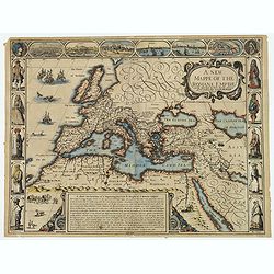
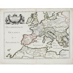
A new mappe of the Romane Empire. . .
This delightful map of the Roman Empire has six lovely bird's-eye vignette views of important cities (Rome, Genoa, Jerusalem, Venice, Constantinople & Alexandria), an...
Place & Date: London, 1626
Selling price: $550
Sold in 2019
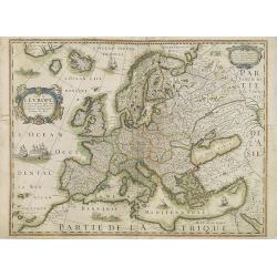
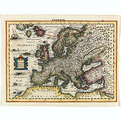
Carte de L'Europe, corrigée et augmentée desus toutes les autres cy ..
Rare map of Europe, dated 1627. First state, issued by Melchoir Tavernier. Most probably engraved by Cornelis Danckerts (the elder), a highly skilled engraver. Most proba...
Place & Date: Paris, 1627
Selling price: $850
Sold in 2019
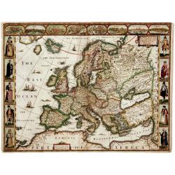
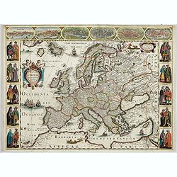
EUROP, and the cheife Cities contayned therin described. . .
A nice impression of this very decorative and prestigious "carte à figures"- map. Speed published the first world atlas in England.Many figures in national cos...
Place & Date: London, 1627
Selling price: $1400
Sold in 2013
![Europ, and the Cheife Cities Contained therein Described... [Europe]](/uploads/cache/94035-250x250.jpg)
Europ, and the Cheife Cities Contained therein Described... [Europe]
A classic decorative map of Europe, published in Speed's "Prospect of the Most Famous Parts of the World", with ten costume vignettes down the sides and eight c...
Place & Date: London c. 1627
Selling price: $500
Sold in 2016
EVROP, and the cheife Cities contayned therin described. . . 1626.
A good impression from an early edition of this famous and decorative cartes-a-figures from the first world atlas produced by an Englishman - John Speed’s Prospect Of T...
Place & Date: London, George Humble, 1627
Selling price: $1200
Sold in 2019
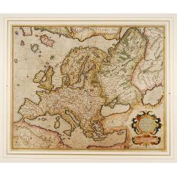
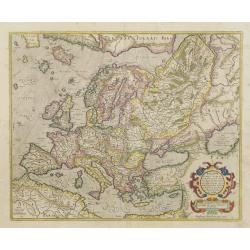
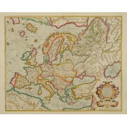
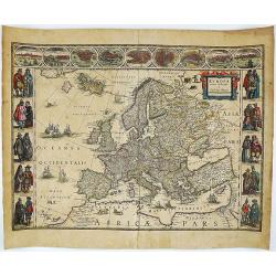
Europa, ad magnae Europae Gerardi Mercatoris..
General map of Europe by one of the greatest mapmakers.
Place & Date: Amsterdam 1630
Selling price: $900
Sold
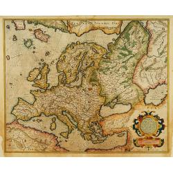
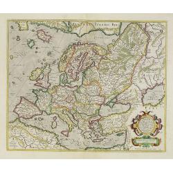
Europa, ad magnae Europae Gerardi Mercatoris..
General map of Europe by one of the greatest mapmakers.Includes an ornate cartouche. The map was updated and the cartouche etc. changed in 1606, making these early exampl...
Place & Date: Amsterdam 1630
Selling price: $860
Sold
Europa, ad magnae Europae Gerardi Mercatoris..
General map of Europe by one of the greatest mapmakers.
Place & Date: Amsterdam, 1630
Selling price: $1600
Sold
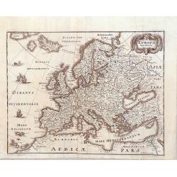
Europa, ad magnae Europae Gerardi Mercatoris ?
General map of Europe by one of the greatest mapmakers.Includes an ornate cartouche. In the upper left corner south-west of Island the mythical island of Frislant.
Place & Date: Amsterdam, 1630
Selling price: $1100
Sold in 2009
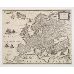
Nova Europae Descriptio.
Map of Europe from the rare Cloppenburg edition "Atlas Sive Cosmographicae Meditationes De Fabrica Mundi Et Fabricati Figura", slightly larger format and more s...
Place & Date: Amsterdam, 1630
Selling price: $200
Sold in 2018
Patriarchatus Romanus . . .
A rare map of the Roman Empire, extending from North Africa to Great Britain and east to the Balkans, adorned with a beautiful cartouche with 2 mermaids. From Melchior Ta...
Place & Date: Paris, 1632
Selling price: $400
Sold in 2021
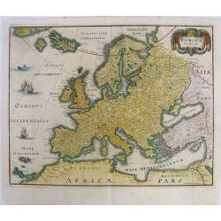
Europa, ad magnae Europae Gerardi Mercatoris..
General map of Europe by one of the greatest mapmakers.
Place & Date: Amsterdam 1633
Selling price: $600
Sold
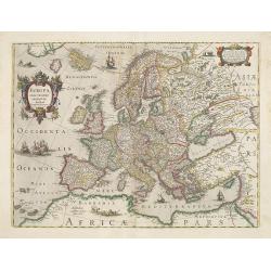
Nova Europae Descriptio.
Very decorative map of Europe decorated with many ships and sea monsters.
Place & Date: Amsterdam 1633
Selling price: $1100
Sold
Europa recens descripta à Guilielmo Blaeuw.
During the printing process the figured borders have been covered. No text on verso. There exists a continent map of the Americas and Asia which has been printed in the s...
Place & Date: Amsterdam 1633
Selling price: $1000
Sold
Europa exactissime descripta.
Very decorative map of Europe decorated with many ships and sea monster. Dated 1631.
Place & Date: Amsterdam, 1633
Selling price: $1400
Sold in 2009
Europa recens descripta a Guilielmo
Very unusual and attractive map of Europe published by Blaeu. This variant not noted in Van der Krogt's new edition of 'Koeman's Atlantes Neerlandici. The bordering figur...
Place & Date: Amsterdam, 1633
Europa recens descripta à Guilielmo Blaeuw.
On either side columns depicting the manner of dress in the major countries of Europe, including those of the English, the French, Hungarians, Germans etc, all surmounted...
Place & Date: Amsterdam, 1634
Selling price: $2900
Sold in 2015
Europa recens descripta a Guilielmo Blaeuw.
On either side columns depicting the manner of dress in the major countries of Europe, surmounted by nine city views and plans. For European mapmakers their own continent...
Place & Date: Amsterdam 1635
Selling price: $3700
Sold
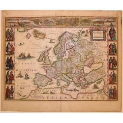
Europa recens descripta à Guilielmo Blaeuw.
On either side columns depicting the manner of dress in the major countries of Europe, surmounted by nine city views and plans.For European mapmakers their own continent ...
Place & Date: Amsterdam, 1635
Selling price: $3100
Sold in 2010
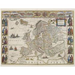
Europa recens descripta à Guilielmo Blaeuw.
On either side columns depicting the manner of dress in the major countries of Europe, surmounted by nine city views and plans.For European mapmakers their own continent ...
Place & Date: Amsterdam, 1635
Selling price: $2750
Sold in 2016
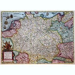
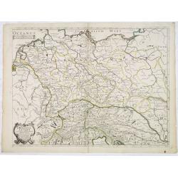
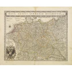
Germaniae nova et accurata delineatio.. 1631.
Very decorative example of Hondius' map of the German Empire, extending from the Low Countries in the Northwest to the Baltic and Russia in the Northeast and Italy and th...
Place & Date: Amsterdam, 1636
Selling price: $171
Sold in 2019
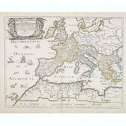
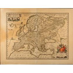
Romani Imperii Qua Occidens est Descriptio Geographica. . .
A fine map of the Roman Empire and includes Europe, Northern Africa, and the Near and Middle East. The map is embellished with ships in the Atlantic and a fine title cart...
Place & Date: Paris, after 1637
Selling price: $120
Sold
![EVROPAM sive CELTICAM VETEREM sic describere conabar Abrahamus Ortelius. [CELTIC EUROPE]](/uploads/cache/37626-250x250.jpg)
EVROPAM sive CELTICAM VETEREM sic describere conabar Abrahamus Ortelius. [CELTIC EUROPE]
Possibly derived to some extent from Ortelius' own two sheet map of the Roman Empire, which appeared in 1571. Further, this map is based on classical sources, such as Sal...
Place & Date: Amsterdam, 1638
Selling price: $400
Sold in 2017
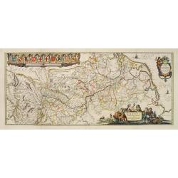
Rhenus Fluviorum Europae..
Shows the course of the River Rhine, showing parts of Switzerland, Austria, The Netherlands and part of Germany.The finest Dutch map publishers were the Blaeu family, and...
Place & Date: Amsterdam 1640
Selling price: $650
Sold
Rhenus Fluviorum Europae..
Shows the course of the River Rhine, showing parts of Switzerland, Austria, The Netherlands and part of Germany.The finest Dutch map publishers were the Blaeu family, and...
Place & Date: Amsterdam, 1640
Selling price: $800
Sold
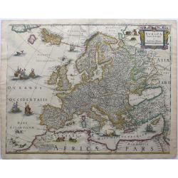
Europa recens descripta a Guilielmo Blaeuw.
Blaeu’s striking map of Europe, framed on both sides by five costumed figures. Left border: Angli, Galli, Belgi, Castiliani, Venetiani. Right border: Germani, Hungari, ...
Place & Date: Amsterdam, 1640
Selling price: $2200
Sold in 2018
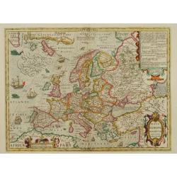
Europa nova delineatio.
Based on Blaeu's Europa recens descripta, this map extends to Iceland, the mythical Frisland, and the coast of Greenland. A decorative cartouche, sailing ships and a sea ...
Place & Date: Frankfurt, 1640
Selling price: $190
Sold in 2015
Europa Nova Delineatio.
This lovely map is based on one of the most famous 17th Century maps of the continent of Europe - Blaeu's Europa recens descripta. The map extends to include Iceland and ...
Place & Date: Frankfurt, 1640
Selling price: $175
Sold in 2019
Germania Antiqua.
A fine map of ancient Germany, Poland and the Netherlands.This edition carries the date 1641.The map was prepared by Melchior Tavernier and later published Pierre Mariett...
Place & Date: Paris, 1641
Selling price: $60
Sold in 2017
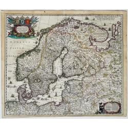
Sveciae, Norvegiae et Daniae, Nova Tabula
Map of Scandinavia, also including Finland, the Baltic States and parts of Russia, Poland, Germany and the Netherlands.Title in a nice cartouche at top left with animals,...
Place & Date: Amsterdam, 1641
Europam sive Celticam veterem. Sic Describere conabur Abrahamus Ortelius
Historical map of Europe, originally attributed to Ortelius also published in Hondius / Mercator Atlas Novus with different catouches. French text on back.
Place & Date: Amsterdam, 1642
Selling price: $400
Sold in 2009
Europam sive Celticum Veterem.
Fine map of ancient Europe. Engraved by Everard Sijmonsz.van Hamersveldt.
Place & Date: Amsterdam 1639-1644
Selling price: $340
Sold
Europa recens descripta à Guilielmo Blaeuw.
On either side columns depicting the manner of dress in the major countries of Europe, surmounted by nine city views and plans.For European mapmakers their own continent ...
Place & Date: Amsterdam, 1644
Selling price: $4000
Sold in 2017
Rhenus Fluviorum Europae..
Shows the course of the River Rhine, showing parts of Switzerland, Austria, The Netherlands and part of Germany.The finest Dutch map publishers were the Blaeu family, and...
Place & Date: Amsterdam, 1644
Selling price: $425
Sold in 2017
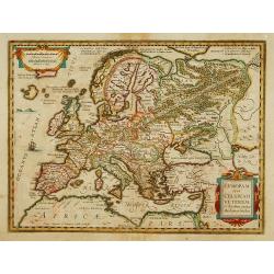
Nova Europae Descriptio Auctoro Hondio.
Very rare map of Europe separately published. The first derivative of the map was issued separately by Hondius in 1618. This example is based upon the second state of Jan...
Place & Date: Paris, 1644
Selling price: $2000
Sold in 2023
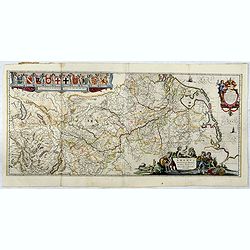
Nova Totius Germaniae Descriptio.
As indication in the title cartouche, the map was prepared by the German cartographer Gaspar Henneberg of Erlich.
Place & Date: Amsterdam 1645
Selling price: $100
Sold
Europa recens descripta à Guilielmo Blaeuw.
On either side columns depicting the manner of dress in the major countries of Europe, surmounted by nine city views and plans.For European mapmakers their own continent ...
Place & Date: Amsterdam 1645
Selling price: $3500
Sold
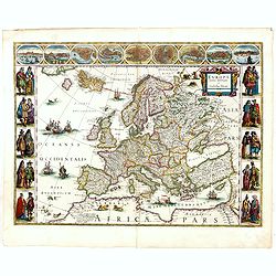
Europa recens descripta.
A classic carte-de-figures map of Europe produced during the golden age of the Dutch mapmaking. The map shows the entirety of Europe, as well as Northern Africa, Iceland,...
Place & Date: Amsterdam, ca. 1645
Selling price: $1550
Sold in 2019