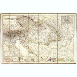
Der Osterreichische Kaiserstaat Entworfen von Herm. Berghaus. . .
Very detailed large-scale 19th century folding map of Austria, published in the birth year of Franz Ferdinand, became Archduke of Austria. Covers from Northern part of It...
Place & Date: Gotha, Justus Perthes, 1863
Selling price: $205
Sold in 2023
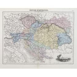
Empire d'Autriche (Empire Autro-Hongrois).
A decorative map of Austria and Hungary from Géographie Universelle, Atlas Migeon, published by J. Migeon. With an engraving of Vienna lower right corner.From one of the...
Place & Date: Paris, 1874
Selling price: $30
Sold in 2012
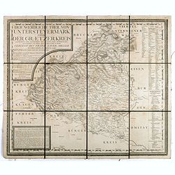
Der noerdliche Theil von Untersteyermark oder der Graetzer Kreis, Entworfen und gezeichnet von Joseph Karl Kindermann
Beautiful, rare and decorative copper engraved map of Styria, Austria. Prepared by Jos. Karl Kindermann, engraved by Christoph Junker in Vienna and published by Xavier Mi...
Place & Date: Graetz, 1789-1894
Selling price: $55
Sold in 2018
![Rhetiae alpestris descriptio in qua hodie Tirolis Comitatus [with] Goritiae, Karstii, Chaczeolae, Carniolae, Histriae, et Windorum Marchae Descrip.](/uploads/cache/99693-250x250.jpg)
Rhetiae alpestris descriptio in qua hodie Tirolis Comitatus [with] Goritiae, Karstii, Chaczeolae, Carniolae, Histriae, et Windorum Marchae Descrip.
Depicts two maps by Abraham Ortelius. A map of Tyrol, Austria is seen on the left while an example of Northern Yugoslavia is on the right.Both are rendered in lovely orig...
Place & Date: Antwerp, 1580
Selling price: $155
Sold in 2010
Partie Septentrionale du Cercle d'Autriche..
Detailed map of Austria, with an ornamental cartouche. Relief shown pictorially.
Place & Date: Paris 1752.
Selling price: $52
Sold
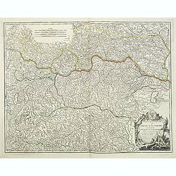
Partie Septentrionale du Cercle d'Autriche. . .
Detailed map of Austria, with an ornamental cartouche. Relief shown pictorially from his "Atlas Universel".Gilles Robert de Vaugondy (1688–1766), also known a...
Place & Date: Paris 1752.
Selling price: $60
Sold
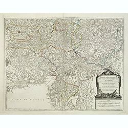
Partie Méridionale du Cercle d'Autriche. . .
Detailed map of Austria, with an ornamental cartouche. Relief shown pictorially from his "Atlas Universel".Gilles Robert de Vaugondy (1688–1766), also known a...
Place & Date: Paris 1752.
Selling price: $60
Sold in 2019
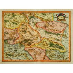
Stiria.
Detailed map of Styria, the most eastern part of Austria, centred on Graz.Signed lower right hand corner Per Gerardum Mercatorem Cum Privilegio.
Place & Date: Amsterdam 1639-44
Selling price: $30
Sold