Browse Listings in Europe
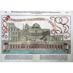
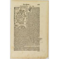
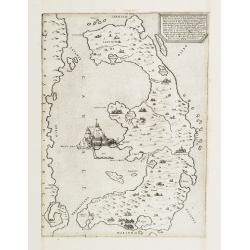
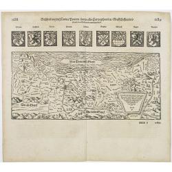
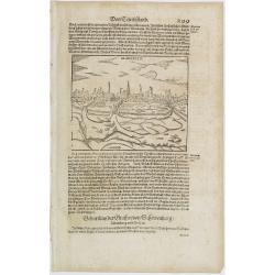
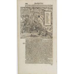
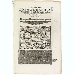
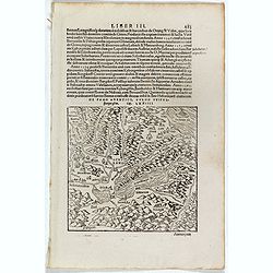
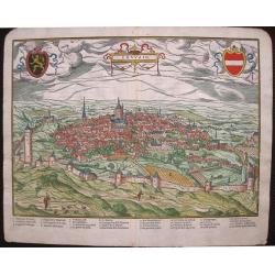
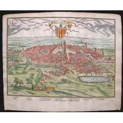
Theatrum Veronense 1549
Fantastic view of the Teatro Romano in Verona from Münster's "Cosmographia". After Hans Rudolf Manuel Deutsch with his monogram RMD shown on the facade. With...
Place & Date: Basle, ca. 1560
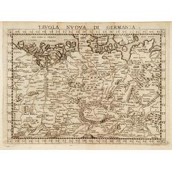
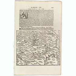
Tavola nuova di Germania.
Map of Germany and parts of the surrounding areas. In the northwest is Flanders and Brabant. In the southwest is Lake Geneva and Budapest is in the southeast. The Vistula...
Place & Date: Venise, 1561
Selling price: $245
Sold
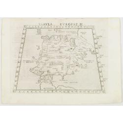
Tabula Europae II. . .
Uncommon first edition of one of this map of ancient Spain and the tip of Africa.Girolamo Ruscelli's edition of Ptolemy's Geographia included newly engraved copperplates ...
Place & Date: Venice, 1561
Selling price: $230
Sold in 2008
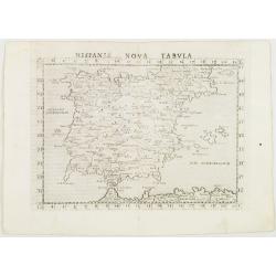
Hispania Nova Tabula. . .
Uncommon first edition of one of the earliest maps of Spain and Portugal.Girolamo Ruscelli's edition of Ptolemy's Geographia included newly engraved copperplates by Giuli...
Place & Date: Venice, 1561
Selling price: $275
Sold in 2008
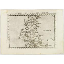
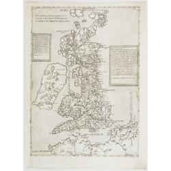
Anglia et Hibernia Nova. . .
Uncommon first edition of one of the earliest maps of Great Britain.Girolamo Ruscelli's edition of Ptolemy's Geographia included newly engraved copperplates by Giulio and...
Place & Date: Venice, 1561
Selling price: $410
Sold in 2008
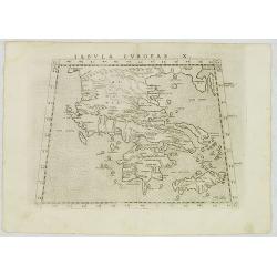
Tabula Europa X . . .
Uncommon first edition of this map of Ancient Greece.Girolamo Ruscelli's edition of Ptolemy's Geographia included newly engraved copperplates by Giulio and Livio Sanuti. ...
Place & Date: Venice, 1561
Selling price: $110
Sold in 2012
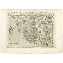
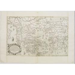
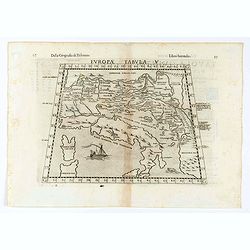
Graetia Nuova Tavola.
Uncommon first edition of this early map of Greece.Girolamo Ruscelli's edition of Ptolemy's Geographia included newly engraved copperplates by Giulio and Livio Sanuti. Th...
Place & Date: Venice, 1561
Selling price: $250
Sold in 2011
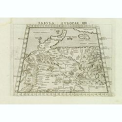
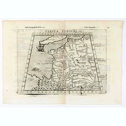
Tabula Europae IIII
Scarce first edition of this classical map of Poland and Germany. The map is an enlarged version of Giacomo Gastaldi's published in 1548.Girolamo Ruscelli's edition of Pt...
Place & Date: Venice, 1561
Selling price: $425
Sold in 2012
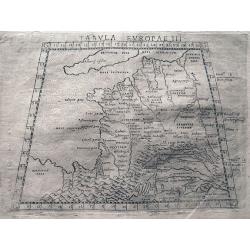
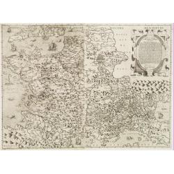
Tabula Europae III.
Ptolemaic style map of France, the Low Countries, and the Rhine river. Includes numerous historic place names. Italian text on verso.
Place & Date: Venice, c1561
Selling price: $54
Sold in 2013
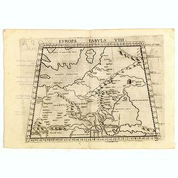
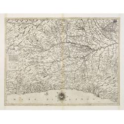
Europae Tabula VIII.
Ptolemaic map of eastern Europe, including a portion of Scandinavia, Poland, Lithuania, Ukraine and Russia, stretching from the Swedish island of Gotland (Gothia Insula) ...
Place & Date: Venice, 1561
Selling price: $200
Sold in 2015
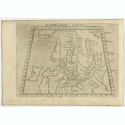
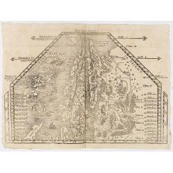
Schonladia Nuova.
Depicting Scandinavia in a trapezoidal projection, being one of the earliest obtainable modern maps of Scandinavia. The map combines Ptolemaic and modern cartographic inf...
Place & Date: Venice, 1561
Selling price: $200
Sold in 2017
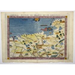
TAVOLA NUOVA DI PRUSSIA ET DI LIVONIA.
An uncommon first edition of this early map of the region from Pomerania to Livonia, including Lithuania,a portion of Estonia, and some coastal detail of the Baltic Sea, ...
Place & Date: Venice, 1561
Selling price: $210
Sold in 2020
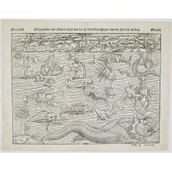
Mörewunder vnd seltzame thier
Spectacular woodcut of mythical land with sea monsters and animals. The monsters were first engraved in the ‘Carta Marina’ of 1539 by Olaus Magnus and have been us...
Place & Date: Basel, 1561
Selling price: $1500
Sold in 2022
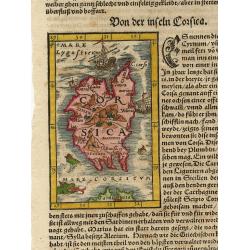
Corsica.
Woodblock map of Corsica surrounded by ships and fierce sea monsters. On a full sheet of German text.
Place & Date: Basle 1562
Selling price: $100
Sold
![[Southern Scandinavia to central Germany, Netherlands and East England]](/uploads/cache/25014-250x250.jpg)
[Southern Scandinavia to central Germany, Netherlands and East England]
The rare second state is dated 1562, but still lacks the imprint of Camocio. The map has no title and extends from Southern Scandinavia to Central Germany, The Netherland...
Place & Date: Venice, 1562
Selling price: $21200
Sold
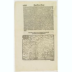
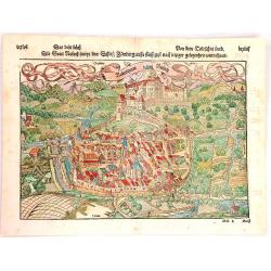
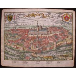
Der Statt Istien und umbligender Landschafft gelegenheit und abcontrafactur.
Text page with a map (122x155mm.) of "Istien". It is a typical woodcut illustration that makes these Münster maps fascinating and sought after by map collector...
Place & Date: Basel, 1562
Selling price: $15
Sold in 2011
Neapolis. / Tiloi.
Text page with two town views of Naples and "Tiloi". It is a typical woodcut illustration that makes these Münster maps fascinating and sought after by map col...
Place & Date: Basel, 1562
Selling price: $80
Sold in 2008
Corsica.
Nice miniature map of Corsica with monsters and ships in the sea. It is a typical woodcut illustration that makes these Münster maps fascinating and sought after by map ...
Place & Date: Basel, 1562
Selling price: $80
Sold in 2008
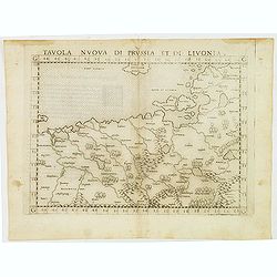
Tavola nuova di Prussia et di Livonia.
A Ptolemaic map of the region from Pomerania to Livonia includes a portion of Estonia and coastal detail on the Baltic Sea with a small section of the island of Gotland a...
Place & Date: Venice, Vincentium Valgrisium, 1562
Selling price: $150
Sold in 2012
Der Statt Istien und umbligender Landschafft gelegenheit und abcontrafactur.
Text page with a map (122x155mm.) of "Istien". It is a typical woodcut illustration that makes these Münster maps fascinating and sought after by map collector...
Place & Date: Basel, 1562
Selling price: $15
Sold in 2012
Andere Landtaffel: In welcher der Moscauen gebuet mit sampt den welden und bergen. . .
One of the earliest obtainable, and first modern map of Russia! With curious details and many place names. Extends from Finland until the Caspian Sea. With sailing ships...
Place & Date: Basel, 1563
Selling price: $1500
Sold in 2020
![[Crete] EL VERO ET NVOVO DISEGNO, DI TVTTA LA ISOLA, DI CANDIA.](/uploads/cache/23788-250x250.jpg)
[Crete] EL VERO ET NVOVO DISEGNO, DI TVTTA LA ISOLA, DI CANDIA.
Fine map of Crete. No further states are recorded.Engraved by Paolo Forlani (active 1561-1577). Title in banner in top. In lower right corner a cartouche including the hu...
Place & Date: Venice 1564
Selling price: $2500
Sold in 2010
Vogliono alcuni l'isola di Corfu fosse prima ..
Fine map of the island of Kerkyra (Corfu), based on a map of the French artist Jacques Prevost. The present edition by Fernando Bertelli (ascribed by D.Woodward to Paolo ...
Place & Date: Venice, 1564
Selling price: $2100
Sold in 2010
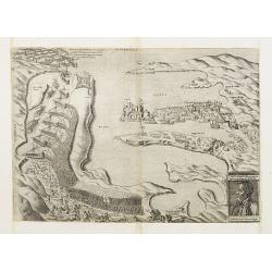
IL PORTO DI MALTA.
Rare plan of the town of Valetta showing the counter attack of the army of Ascanio against the Turks. Thirteen departing Turkish galleys have been engraved within "P...
Place & Date: Venice, after 1564
Selling price: $4200
Sold
Britania Insula quae dup Regna continet Angliam et Scotiam cum Hibernia adiacente. Ferando Berteli exc. 1561. Venise: 1562
One of the earliest printed maps of England. The essential roots of mid-16th century mapping of the British Isles go back to the English catholic priest George Lily (ca 1...
Place & Date: Venice, 1564
Selling price: $16800
Sold
Totius Graeciae Descriptio.
A rare map of Greece. One of the first printed maps of Greece, decorated with many ships. A unique opportunity to acquire a fine example of a map from the early Lafreri s...
Place & Date: Venice, 1564
Selling price: $14250
Sold in 2010
![[Von dem königreich Poland das in Sarmatia auch..]](/uploads/cache/22813-250x250.jpg)
[Von dem königreich Poland das in Sarmatia auch..]
Early wood block printed map of Poland. Set in a page of German text.Taken from Sebastian Münster's encyclopedic work, the "Cosmographia Universalis". The Cosm...
Place & Date: Basle, 1564
Selling price: $100
Sold in 2010
Das Pomerisch Meere.
RECTO: A double-page map of Pomeren, today's Poland. Illustrated in upper portion nine coats of arms of the duchies of the region. VERSO: a small map of the Prussian coas...
Place & Date: Basle, ca. 1564
Selling price: $150
Sold in 2009
Friesland.
RECTO: A map of Friesland. VERSO: two woodcuts of two mice, one entering a mouse trap, and the other of a pope.Taken from Sebastian Munster's encyclopedic work, the "...
Place & Date: Basle, ca. 1564
Selling price: $50
Sold in 2009
![Beschreibung der Statt Antorff? [Antwerp ]](/uploads/cache/27204-250x250.jpg)
Beschreibung der Statt Antorff? [Antwerp ]
RECTO: a bird's-eye-view of a Antwerp. VERSO: a woodcut portrait of Alfa. Taken from Sebastian Munster's encyclopedic work, the "Cosmographia Universalis". The ...
Place & Date: Basle, ca. 1564
Selling price: $30
Sold in 2010
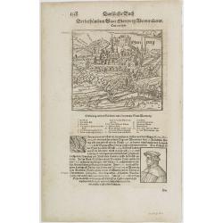
Martpurg (Marburg)
RECTO: A print of the city of Marburg in Germany illustrated in lower right portion by a woodcut of a scholar . VERSO: a small map of a provincial German village.Taken fr...
Place & Date: Basle, ca. 1564
Selling price: $10
Sold in 2014
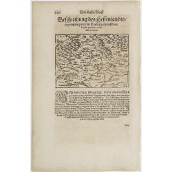
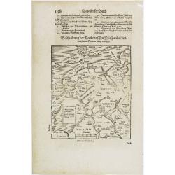
Hessen.
RECTO: A map of the city of Hessen in Germany illustrated in lower right portion by a woodcut of a scholar.Taken from Sebastian Münster's encyclopedic work, the Cosmogra...
Place & Date: Basle, ca. 1564
Selling price: $50
Sold in 2012
Das Funffte Buch. Aldenburg.
RECTO: A map of the city of Aldenberg in Germany. Taken from Sebastian Münster's encyclopedic work, the Cosmographia Universalis. The Cosmographia by Sebastian Münster ...
Place & Date: Basle, ca. 1564
Selling price: $10
Sold in 2014
Wittenburg. / Portrait of Luther
RECTO: A map of the city of Wittenburg in Germany illustrated in lower right portion by a woodcut of Luther. VERSO: a woodcut of a Pope.Taken from Sebastian Münster's en...
Place & Date: Basle, ca. 1564
Selling price: $50
Sold in 2011
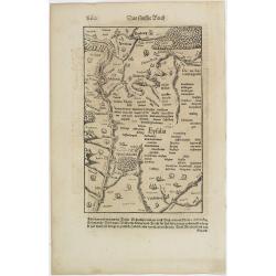
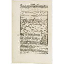
Eyfalia.
RECTO: a map of the area around Cologne, including the Dutch province Limburg and part of Luxemburg. VERSO: a woodcut of a Turkish bath scene and the its outside surround...
Place & Date: Basle, ca. 1564
Selling price: $20
Sold in 2009
Munster.
A of Münster in Germany. VERSO: a woodcut of a coat of arms.Region known for its agriculture, dairy farming, livestock raising.Taken from Sebastian Münster's encyclope...
Place & Date: Basle, ca. 1564
Selling price: $30
Sold in 2012
Das Funffte Buch. Mitnacht.
Town-plan of Mitnacht with a key: A-Q. VERSO: a woodcut of a scholar. Taken from Sebastian Münster's encyclopedic work, the "Cosmographia Universalis". The &qu...
Place & Date: Basle, ca. 1564
Selling price: $20
Sold in 2012
Rubeaquum Rusach (Château D'Isenbourg)
Rubeaquum Rufach is a detailed woodcut by Sebastian Münster showing the famous Château D'Isenbourg located in the heart of the vineyards on the Alsace wine route and th...
Place & Date: Basil, 1564
Selling price: $30
Sold in 2018
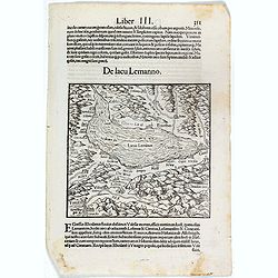
De Lacu Lemanno. (Lake Geneva)
One Latin text page with a woodcut map of Lake Geneva (147x157mm). From Münster's Cosmographia Universalis. The Cosmographia by Sebastian Münster from 1544 is the earli...
Place & Date: Basle, ca. 1564
Selling price: $30
Sold in 2017
![Bohemici Regni . . . [Czechoslovakia]](/uploads/cache/38517-250x250.jpg)
Bohemici Regni . . . [Czechoslovakia]
One Latin text page with a wood cut engraved map of Czechoslovakia centered on Prague (93 x 135 mm). From Münster's Cosmographia Universalis.The Cosmographia by Sebastia...
Place & Date: Basle, ca. 1564
Selling price: $15
Sold in 2016
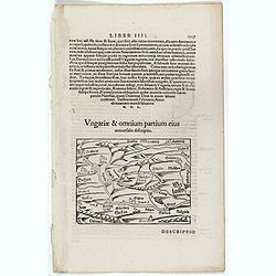
Ungariae & Omnium partium eius. (Hungary)
One Latin text page with a wood cut engraved map of Hungary (100 x 135 mm). From Münster's Cosmographia Universalis. The Cosmographia by Sebastian Münster from 1544 is ...
Place & Date: Basle, ca. 1564
Selling price: $10
Sold in 2016
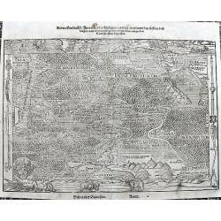
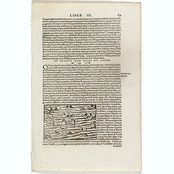
Descriptio Germanicae nationis propter . . .
One text page with a small wood cut map of central Europe (10 x 13,5 cm) with south to the top. On verso, Latin text with German locals. From Münster's Cosmographia Univ...
Place & Date: Basle, ca. 1564
Selling price: $25
Sold in 2019
Transsylvania Ungarici Regni Provincia.
One text page with a map of Hungary, Moravia and Macedonia (150 x 190 mm). On verso Latin text page with a small wood cut of a monastery on a mountain.From Münster's Cos...
Place & Date: Basle, ca. 1564
Selling price: $25
Sold in 2016
![[ Wood cut map of Russia centered on Moscovy]](/uploads/cache/38528-250x250.jpg)
[ Wood cut map of Russia centered on Moscovy]
One text page with a map of Russia, centered on Moscovie (175 x 160 mm). On verso, a text page in one hand , and in the other a horn from Münster's Cosmographia Universa...
Place & Date: Basle, ca. 1564
Selling price: $80
Sold in 2017
![[Versalis Lib I]](/uploads/cache/38533-250x250.jpg)
[Versalis Lib I]
One text page with Latin text with reference to Delos, Rhodes, Alone, Thera/ Sicilia and Therasia, illustrated with a fancy wood cut map (130 x 145 mm) with three dimensi...
Place & Date: Basle, ca. 1564
Selling price: $25
Sold in 2018
![[De Germania - Prinum Suitenfium Foedus]](/uploads/cache/38536-250x250.jpg)
[De Germania - Prinum Suitenfium Foedus]
One Latin text page telling a story from the years 1316-1323. Illustrated with a wonderful wood block print of medieval knights and men shown in a highly stylized primiti...
Place & Date: Basle, ca. 1564
Selling price: $15
Sold in 2017
![[ Zürich ]](/uploads/cache/38542-250x250.jpg)
[ Zürich ]
One Latin text page with a wood-cut illustration of Zürich (120 x 173 mm). From Münster's Cosmographia Universalis. The Cosmographia by Sebastian Munster from 1544 is t...
Place & Date: Basle, ca. 1564
Selling price: $14
Sold in 2022
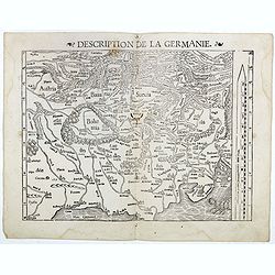
Description de la Germanie.
A wood cut printed map of Germany, The Low Countries, Poland, Austria and Switzerland (345 x 250). South to the top and a scale to the right. On verso French text.From M�...
Place & Date: Basle, ca. 1564
Selling price: $80
Sold in 2016
![[Bull from Lithuania]](/uploads/cache/38520-250x250.jpg)
[Bull from Lithuania]
One text page with a map of a bull on the recto (11 x 14 cm). On verso, a description of Poland and Russia taken from Münster's Cosmographia Universalis.The Cosmographia...
Place & Date: Basle, ca. 1564
Selling price: $10
Sold in 2018
![[De Galliae et eius fitu, item de eius patitione . . . . . . ]](/uploads/cache/38525-250x250.jpg)
[De Galliae et eius fitu, item de eius patitione . . . . . . ]
One text page with a map of France on the recto (7,8 x 13,5 cm). On verso, a text page in one hand , and in the other a horn from Münster's Cosmographia Universalis.The ...
Place & Date: Basle, ca. 1564
Selling price: $25
Sold in 2018
![[De Regionibus, Ubibus et Fluviis Galliae . . . ]](/uploads/cache/38524-250x250.jpg)
[De Regionibus, Ubibus et Fluviis Galliae . . . ]
One text page with a map of Europe on the recto (12,2 x 15,5 cm). From Münster's Cosmographia Universalis.The Cosmographia by Sebastian Munster from 1544 is the earliest...
Place & Date: Basle, ca. 1564
Selling price: $25
Sold in 2022
De Batavia Quae Hodie est Holandia.
One text page with an illustration of floating in the Netherland on the recto. From Münster's Cosmographia Universalis.The Cosmographia by Sebastian Münster from 1544 i...
Place & Date: Basle, ca. 1564
Selling price: $10
Sold in 2018
De pago aventico vulgo Wifelspurgergow. . .
A lovely detailed wood cut map of South-western Switzerland it shows Geneva, Lake Geneva, Lake Neuchatel, Lake Biel, Bern, Freiburg, Lake Thuner, etc (150 x 155 mm). On v...
Place & Date: Basle, ca. 1564
Selling price: $10
Sold in 2020
Tabula Europae III (France)
Early map of France. Girolamo Ruscelli first published the map in his "La Geographi di Claudio Tolomeo" (Venice, 1561). In 1574 a new plate was used which laste...
Place & Date: Venice, 1564
Selling price: $60
Sold in 2020
Tabula Europae V.
Early map of the Balkans. Girolamo Ruscelli first published the map in his "La Geographi di Claudio Tolomeo" (Venice, 1561). In 1574 a new plate was used which ...
Place & Date: Venice, 1564
Selling price: $60
Sold in 2020
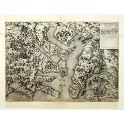
Ultimo disegno delli forti di Malta uenuto novamente. . . Ant. Lafrerj Romae formis 1565 de Mese Augusti.
A rare and important map showing the Great Siege of Malta which took place in 1565 when the Ottoman Empire invaded the island, then held by the Knights HospitallerThe Kni...
Place & Date: Rome, 1565
Selling price: $6400
Sold in 2010
Galliae exactissima descriptio.
A unique opportunity to acquire a fine example from a map from the early Lafreri school. It was the custom for Italian map sellers to bind together available maps into a ...
Place & Date: Venice, 1566
Selling price: $4500
Sold
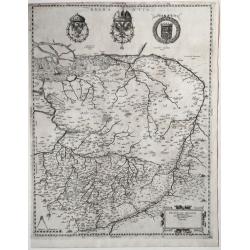
Descrittione del Piamonte Mon- / ferra, et la maggior parte della / Riuiera di Genoua, con jl territorio / Astesano, Alexandrino Tortonese, / Nouarese, et la maggior parte del ..
Fine map of Piedmont, with the Mediterranean coast including Monaco till Genoa, and Milan on the top. In the center is the river PO. State 3 of 5, with the name of Camoci...
Place & Date: Venice, 1566
Selling price: $4900
Sold in 2012
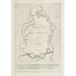
DISEGNO VERO DELLA NVOVA CITTA DI MALTA.
Rare fortification plan of the town of Valletta. Engraved by Paolo Forlani (active 1561-1577).With hatching to highlight the ditch on the landward side of Valletta. It se...
Place & Date: Venice 1566
Selling price: $1500
Sold
![[untitled map of Spain and Portugal] Al Molto Mag et Ecc Alessandro Serego, Che lo studio della Geografia..](/uploads/cache/25016-250x250.jpg)
[untitled map of Spain and Portugal] Al Molto Mag et Ecc Alessandro Serego, Che lo studio della Geografia..
A rare map of Spain and Portugal, with an oversized Majorca. One of the first printed maps of Cyprus. A unique opportunity to acquire a fine example of a map from the ear...
Place & Date: Venice, 1566
Selling price: $9000
Sold in 2010
![[Gÿor] Iavarino in Ongaria et trinciere dove al presente al ritrova lo Imperatore aloggiato con lo essercito . . .](/uploads/cache/25020-250x250.jpg)
[Gÿor] Iavarino in Ongaria et trinciere dove al presente al ritrova lo Imperatore aloggiato con lo essercito . . .
Showing the siege of Iavarin (nowadays Gÿor). Title in a cartouche lower left, with compass rose, date 1566 and initials of Marios Kartaro. A unique opportunity to acqui...
Place & Date: Venice, 1566
Selling price: $1000
Sold in 2010
![[Gÿor] Iavarino in Ongaria et trinciere dove al presente al ritrova lo Imperatore aloggiato con lo essercito ...](/uploads/cache/32490-250x250.jpg)
[Gÿor] Iavarino in Ongaria et trinciere dove al presente al ritrova lo Imperatore aloggiato con lo essercito ...
Showing the siege of Iavarin (nowadays Gÿor). Title in a cartouche lower left, with compass rose, date 1566 and initials of Marios Kartaro.A unique opportunity to acquir...
Place & Date: Venice, 1566
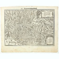
IIII. Die ganz Eydgnoschafft.
Very early wood cut printed map of Switzerland.Originally engraved in 1548. The map was prepared by Johannes Stumpf (1500-1576) and engraved by Heinrich I. Vogtherr (1490...
Place & Date: Zurich, Christoffel Froschover, 1548,1552-1566
Selling price: $900
Sold in 2021
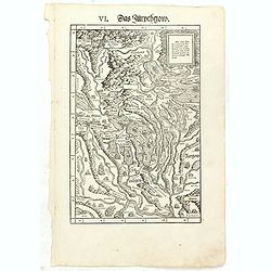
VI. Das Zürychgow.
Very early wood cut printed regional map of Switzerland centered on Zurich.Originally engraved in 1548. The map was prepared by Johannes Stumpf (1500-1576). Included in &...
Place & Date: Zurich, Christoffel Froschover, 1548,1552-1566
Selling price: $400
Sold
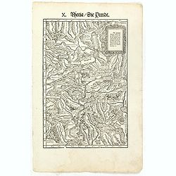
X. Rhetia. Die Pündt.
Very early wood cut printed regional map of Switzerland with River Rhine.Originally engraved in 1548. The map was prepared by Johannes Stumpf (1500-1576). Included in &qu...
Place & Date: Zurich, Christoffel Froschover, 1548,1552-1566
Selling price: $400
Sold in 2018
![[Gotha] GOTTA. Alli 25 di Gennaro 1567 su posto l'assedio sotto la gr: an fortezza..](/uploads/cache/23811-250x250.jpg)
[Gotha] GOTTA. Alli 25 di Gennaro 1567 su posto l'assedio sotto la gr: an fortezza..
Rare plan of the town and siege of Gotha in 1567. In the foreground nice depiction of tents and soldiers on horses.Engraved by Nicolo Nelli.Collector's item. A unique opp...
Place & Date: Venice 1567
Selling price: $2000
Sold
![[Double-page woodcut map of Malta]](/uploads/cache/14964-250x250.jpg)
[Double-page woodcut map of Malta]
Very rare wood-block map of Malta, one of the earliest obtainable separately issued map of the island. Includes several sailing ships and a large compass card to the righ...
Place & Date: Rome, 1567
Selling price: $3000
Sold in 2011
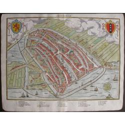
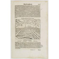
Amsterdam.
One of the oldest plans of Amsterdam, from the first edition of the book by Lodovico Guicciardini, Descrittione di tutti i Paesi Bassi, in its French translation from 156...
Place & Date: Antwerp, 1567
Selling price: $400
Sold in 2015
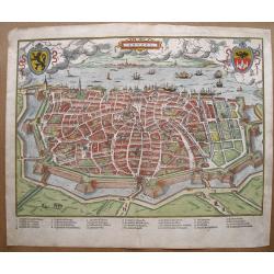
Anvers.
Charming and highly detailed bird’s-eye plan of Antwerpen with attractive pictorially drawn buildings, walls, churches, ships, and towers. Very early woodblock print pr...
Place & Date: Antwerp, 1567
Selling price: $250
Sold in 2018
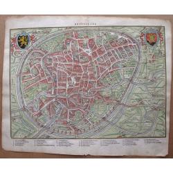
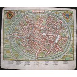
Brusselles.
Charming bird’s-eye plan of Brussel with attractive pictorially drawn buildings, walls, churches, and towers. Very early woodblock print printed in 1567 by Silvius with...
Place & Date: Antwerp, 1567
Selling price: $250
Sold in 2014
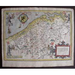
Particvliere description de Flandres.
Famous bears’ map of Flanders, showing the four bears reflecting the four baronies of Flanders and their flags: Syson, Heyne, Pamele en Boelare. Charming bird’s-eye m...
Place & Date: Antwerp, 1567
Selling price: $285
Sold in 2020
Brugae - Brugge
Rare and charming woodcut of Brugae or Brugge. Extensive legend below the plan including thirty-four letter press names of churches, palaces, monasteries, and more. Coat ...
Place & Date: Antwerp, 1567
Selling price: $350
Sold in 2018
Louvain - Leuven.
Rare and charming woodcut of Louvain or Leuven. Extensive legend below the plan including thirty letter press names of churches, palaces, monasteries, and more. Coat of a...
Place & Date: Antwerp, 1567
Selling price: $190
Sold in 2015
Malines - Mechelen
Rare and charming woodcut of Malines or Mechelen. The extensive legend below the plan including nineteen letterpress names of churches, palaces, monasteries, and more, an...
Place & Date: Antwerp, 1567
Selling price: $200
Sold in 2018
Yprae - Ieper
Rare and charming woodcut of Yprae, or Ieper. Extensive legend below the plan including twenty letter press names of churches, palaces, monasteries, and more. Coat of arm...
Place & Date: Antwerp, 1567
Selling price: $140
Sold in 2015
(SCANDINAVIE). Monogr. THW (Thomas Weber) dated 1567.
Rare and important map of Scandinavia from Olaus Magnus' Historia Olai Magni gothi archiepiscop upsalensis, de gentium septentrionalium, published in Basel in 1567.The ma...
Place & Date: Basle, 1567
Selling price: $7000
Sold in 2019
![FRANCKFORT [Frankfurt]](/uploads/cache/38740-250x250.jpg)
FRANCKFORT [Frankfurt]
Rare Lafreri School town-plan of Frankfurt, engraved by Paolo Forlani, of the Lafreri school of mapmakers, first published in "Il Primo Libro Delle Citta, Et Fortezz...
Place & Date: Venice, Zaltieri, (1567) 1567
Selling price: $790
Sold in 2016
![CHALES [Calais]](/uploads/cache/38742-250x250.jpg)
CHALES [Calais]
Rare Lafreri School town-plan of Calais, engraved by Paolo Forlani, of the Lafreri school of mapmakers, first published in "Il Primo Libro Delle Citta, Et Fortezze P...
Place & Date: Venice, Zaltieri, (1567) 1567
Selling price: $60
Sold in 2018
![GINEVRA [Geneve]](/uploads/cache/38743-250x250.jpg)
GINEVRA [Geneve]
Splendid and rare Lafreri School town-plan of Geneva, Calvin's paradise on earth, with index, lake of Lausanne and dated 1567, engraved by Paolo Forlani, of the Lafreri s...
Place & Date: Venice, Zaltieri, (1567) 1567
Selling price: $790
Sold in 2017
Brabantia Belgarum Provinciae recens exactaque descriptio Venetiis.
A very early Brabant map, published in Venice, 1567.In excellent condition, and uncolored. On centre top, the crowned coat of arms of the Emperor Charles V with the emble...
Place & Date: Venice, 1567
Selling price: $2200
Sold in 2020