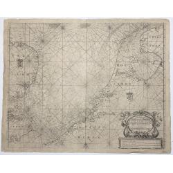
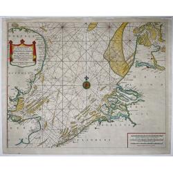
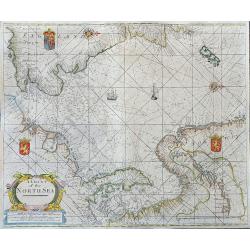
Pas Caert van Texel tot aen de Hoofden.
An attractive chart of the North Sea. Hendrick Doncker was one of the leading Amstrdam-based publshers of sea-atlases and sea charts
Place & Date: Amsterdam, 1659
Selling price: $650
Sold in 2023
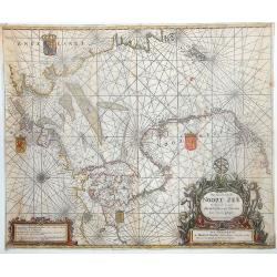
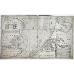
![Kaert van Groen-Land [Map of Greenland]](/uploads/cache/48503-250x250.jpg)
Kaert van Groen-Land [Map of Greenland]
A very rare map of the Northern Atlantic Ocean, showing the North American coast, Greenland, Scotland and the coast of Norway. In the Atlantic are Iceland and the mythica...
Place & Date: Nuremberg or Netherlands, after 1679
Selling price: $650
Sold in 2023
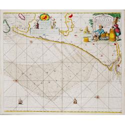
Nieuwe Paskaert van de Kust van HOLLANDT - Tussen Texel en de Maes.
Nieuwe Paskaert van de Kust van Hollandt Tussen Texel en de Maes. A very attractive sea chart off the coast of Holland by Johannes van Keulen with a pair of decorative c...
- $500 / ≈ €468
Place & Date: Amsterdam, ca 1685
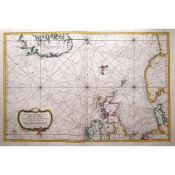
Pas Caart van de Noort Zee Verthoonende in zich Alle de Custen en Havens daer Rontom Gelegen. . .
Scarce nautical panoramicchart of the North Sea, oriented to the West, it shows the coastlines and locations with great details. It has a sequence number 2 in lower right...
Place & Date: Amsterdam, 1686
Selling price: $750
Sold in 2013
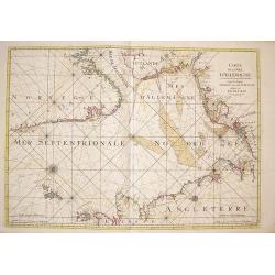
Carte de la Mer d'Allemagne contenant les Bancs Isles et Costes comprises depuis Bergen et les Isles Schetland jusques au Pas De Calais
Large sea chart of the North Sea shows the coast lines of Norway from Bergen south to the Skagerrak, of the west coast of Denmark, the North Sea coast of Germany, Holland...
Place & Date: Amsterdam, 1693
Selling price: $750
Sold in 2009
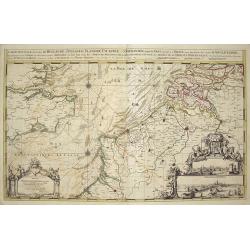
Carte Nouvelle des Costes de Hollande, Zéelande, Flandre, Picardie & Normandie,...
Large chart of the Dutch, Belgian and northern French Coastlines, along with part of the English Channel and the southwest coast of England. Includes large views of Calia...
Place & Date: Amsterdam, 1693
Selling price: $1000
Sold in 2010
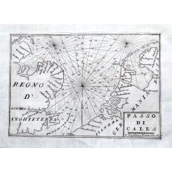
Passo di Cales.
A scarce sea-chart of the Southern Bight of the North Sea with parts of the Netherlands, Belgium, and Great Britain. With main coastal cities shown and many depth soundin...
Place & Date: Venice, 1706
Selling price: $100
Sold in 2018
![[Lot of 5 maps of the mouth of the Gironde river] Carte des Entrees et Cours de la Gironde](/uploads/cache/86010-250x250.jpg)
[Lot of 5 maps of the mouth of the Gironde river] Carte des Entrees et Cours de la Gironde
A large sea chart of the mouth and course of the Gironde river as far inland as Bordeaux. Decorated with three cartouches.Jacques Nicolas Bellin (1702-720) was the most i...
Place & Date: Paris, c. 1740
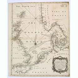
A correct Chart of the German Ocean from the North of Scotland to the Start Point. . .
A large sea chart of the eastern half of the English Channel, the eastern coasts of England and Scotland, the French coast from Normandy and the Channel Islands, up throu...
Place & Date: London, 1745
Selling price: $32
Sold in 2020
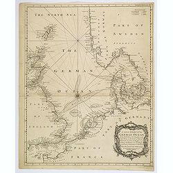
A correct Chart of the German Ocean, from the North of Scotland to the Start Point. . .
A chart of the German Ocean published in Nicholas Tindal’s continuation of Rapin de Thoyras’s “History of England”, it includes compass rose and a large decorativ...
Place & Date: London, 1746
Selling price: $50
Sold in 2019
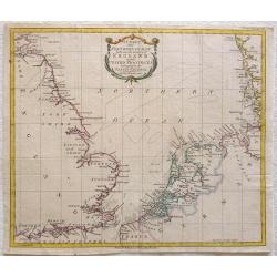
A Correct Chart of the Sea Coasts of England, Flanders, and Holland…
Nice example of Mount & Page's map of the Channel showing the coastlines of England, Belgium and Holland.Published at first in 1671-1672 in John Seller's 'The English...
Place & Date: London, ca. 1750
Selling price: $525
Sold in 2021
Nieuwe paskaart van het zuyderste gedeelte der Noord-Zee strekkende van Texel tot aande Hoofden...
Fine chart of the North Sea with the coasts of Belgium, Netherlands and South East England. Decorated with soundings, compass card, ship. Full title in a cartouche at bot...
Place & Date: Amsterdam, 1728-1751
Selling price: $750
Sold in 2021
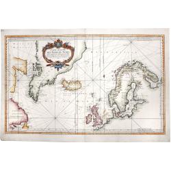
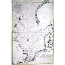
CARTE REDUITE DES MERS DU NORD. Pour serive aux Vaisseaux du Roy.
A large, striking hand-colored map of the North Sea, depicting the Scandinavia peninsula, the United Kingdom, Greenland, east coasts of today's US and Canada and centered...
Place & Date: Paris, 1751
Selling price: $450
Sold in 2019
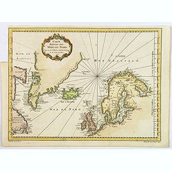
Carte Reduite des Mers du Nord.
A nice detailed sea chart of the coasts of Scandinavia, the British Isles, Iceland, Greenland and contiguous parts of Canada. Includes a decorative title cartouche. One o...
Place & Date: Paris, 1758
Selling price: $90
Sold in 2021
A Chart of the North Sea
Very rare sea-chart after Thornton by George Grierson. Scotish born George Grierson was one of the most important publishers, editors and mapmakers in 18th-century Irela...
Place & Date: Dublin, c1767
Selling price: $600
Sold in 2023
Carte Réduite de Partie de la Mer du Nord comprise entre L'Ecosse, Le Dannemark, La Norwege et l'Islande.
A beautiful chart of the North Sea and part of the Atlantic Ocean, showing Norway, the Faroe Islands, Denmark, the British Isles and Iceland. English towns accessible by ...
Place & Date: Paris, 1768
Selling price: $280
Sold in 2014
A Chart of the Northern Ocean between the coasts of England and the United Provinces belonging tot the States General
Printed for R. Baldwin at the Rose Pater Noster Row. From London Magazine January 1781. Map of the Noth Sea or Northern Ocean with the coasts of Dorset, Hampshire, Succes...
Place & Date: London, 1781
Selling price: $65
Sold in 2013
Charta öfver Nordsjön...
Very rare and large Swedish sea-chart of the North Sea between the British Isles, Norway, Denmark, and the Netherlands. Includes Trondheim, Christiania (Oslo), Fredriksta...
Place & Date: Stockholm, 1797
Selling price: $201
Sold in 2016