Browse Listings in Europe
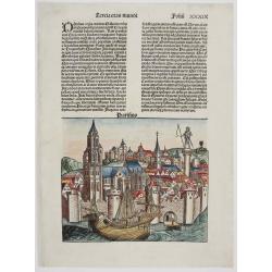
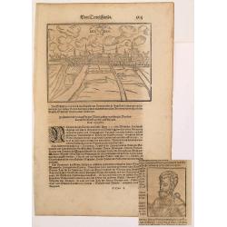
![[Austria] Quita Etas Mundi. Folium. CCLXXVIII](/uploads/cache/46235-250x250.jpg)
[Austria] Quita Etas Mundi. Folium. CCLXXVIII
The Latin text page with a description of Austria among a fanciful pictorial map of Austria (194 x 224mm.) Nuremberg Chronicle, published the year that Columbus returned...
Place & Date: Nuremberg, 12 July 1493
Selling price: $120
Sold in 2021
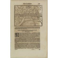
![Quita Etas Mundi. Foliu XXVI [ith a view of Rhodes]](/uploads/cache/46252-250x250.jpg)
Quita Etas Mundi. Foliu XXVI [ith a view of Rhodes]
The Latin text page is illustrated with a view of Rhodes in the South Aegean Sea (177 x 222mm.) The Nuremberg Chronicle, published the year that Columbus returned to Euro...
Place & Date: Nuremberg, 12 July 1493
Selling price: $150
Sold in 2020
![Ordnung der churfursten des reichs / Die siben churfursten Des heiligen romische reichs. [3 sheets joined with 2 double page views!]](/uploads/cache/84732-250x250.jpg)
Ordnung der churfursten des reichs / Die siben churfursten Des heiligen romische reichs. [3 sheets joined with 2 double page views!]
Three sheets with two double page engravings joined together, with the first showing the then main cities of the Holy Roman Empire of German nation The second shows the E...
Place & Date: Nuremberg, 1493
Selling price: $600
Sold in 2020
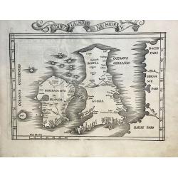
![Anglia / Hispania [England and Spain, two views on one page]](/uploads/cache/84790-250x250.jpg)
Anglia / Hispania [England and Spain, two views on one page]
Incunable sheet with two woodcut engravings of imaginary Views of 'Anglia'/England or Great Britain, and 'Hispania'/Spain on the back [Please view additional picture From...
Place & Date: Nuremberg, 1493
Selling price: $150
Sold in 2020
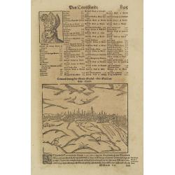
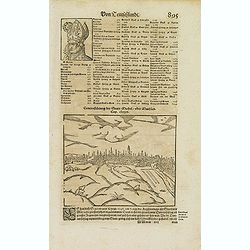
![[Jews burned alive during the southern German pogroms of 1298 ] Terta etas mudi Folio CCXX](/uploads/cache/46240-250x250.jpg)
[Jews burned alive during the southern German pogroms of 1298 ] Terta etas mudi Folio CCXX
With a wood block cut of Jews burned alive during the southern German pogroms of 1298. Dimensions of 116x155mm. On recto illustrations of Kings, doctor, comet, etc. Folio...
Place & Date: Nuremberg, 12 July 1493
Selling price: $50
Sold in 2021
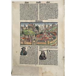
PATAVIA (Passau, Germ)
From the first Latin text edition, 1493. The view of PATAVIA (nowadays the city of Passau, Southern Germany) was part of the Liber Chronicarum cum figuris et ymagibus ...
Place & Date: Nuremberg, Germany, 1493
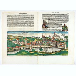
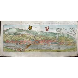
Bamberga. Folium CLXXV
Double page panoramic view of Bamberg. One of the earliest obtainable view of this period.Two page from the richest illustrated Incunable, the famous: Nuremberg Chronicl...
Place & Date: Nuremberg, 12 July 1493
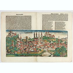
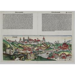
Constancia.
The oldest panoramic view of Constance at the Lake Constance (Bodensee) from the Schedel’s Nuremberg Chronicle. Verso text and several little woodcuts including popes a...
Place & Date: Nurenberg, 1493
Praga
First printed view of Prague, Czech Republic, by Hartmann Schedel from the Latin edition of the “Liber chronicarum” published in 1493. The woodcut is quiet realistic ...
Place & Date: Nurenberg, 1493
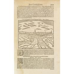
![Quarta etas mudi Folio LVIII [Rome]](/uploads/cache/48488-250x250.jpg)
Quarta etas mudi Folio LVIII [Rome]
Double text page in German with a woodblock Rome (23x53cm.)On verso a view of Genua (193x222mm). Page from the richest illustrated Incunable, the famous: Nuremberg Chro...
Place & Date: Nuremberg, 12 July 1493
Parisius & Maguncia
The imaginary view of Paris, France and Munich, Germany (verso) by Hartmann Schedel from the Latin edition of the “Liber chronicarum”.
Place & Date: Nurenberg, 1493
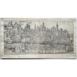
Basilea (Basel)
Probably the first-ever, woodcut view of the city of Basel in Switzerland from a 15th-century incunable.Page from the richest illustrated Incunable, the famous: Nuremberg...
Place & Date: Nüremberg, 1493
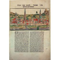
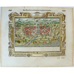
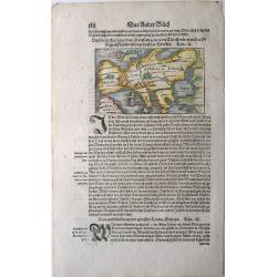
Serta etas mundi Solium Lir Vienna Pannonie
A beautiful wood-cut panorama of Vienna from the "small" NUREMBERG CHRONICLE, one of the earliest printed atlases to feature views of European towns and cities....
Place & Date: Augsburg, Johann Schönsperger. 1497
Selling price: $210
Sold in 2009
Mantua (Mantova).
This very rare woodcut depicting the Italian city of Mantova is from the reduced version of Hartman Schedel's 'Nuremberg Chronicle', sometimes called the 'mini-Schedel'.I...
Place & Date: Augsburg, 1497
Selling price: $190
Sold in 2022
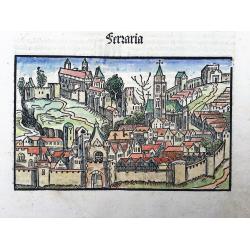
Ferraria (Ferrara)
This very rare woodcut depicting the Italian city of Ferrara is from the reduced version of Hartman Schedel's 'Nuremberg Chronicle', sometimes called the 'mini-Schedel'.I...
Place & Date: Augsburg, 1497
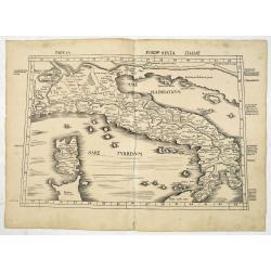
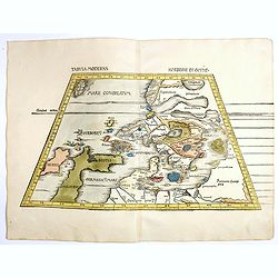
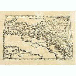
Tabula Europ. Sexta Italiae (Italy)
Wood block printed large-format Ptolemaic map showing Italy with Corsica, Sardinia and part of Sicily, from the 1513 edition of Waldseemüller's Geographia.One of the ear...
Place & Date: Strasburg, 1513
Selling price: $4500
Sold in 2013
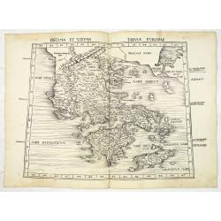
Decima et Ultima Tabula Europae. (Greece)
Wood block printed large-format Ptolemaic map showing Greece from the 1513 edition of Waldseemüller's Geographia.One of the earliest obtainable maps of the region.This P...
Place & Date: Strasburg, 1513
Selling price: $3500
Sold in 2013
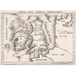
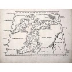
Tabula nova Hibernie Anglie et Scotie.
Martin Waldseemuller's issue of "Geographia," published in 1513 and 1520, was one of the most important atlases of the first half of the sixteenth century as th...
Place & Date: Strasbourg, 1513-1520
Selling price: $4000
Sold in 2009
Tabula Moderna Norbegie et Gottie.
Rare woodblock map of Scandinavia published by Waldseemüller, from the first modern atlas, because the 20 new maps in this atlas show all parts of the world based on con...
Place & Date: Strasbourg, Johann Schott, 1513-1520
Selling price: $6000
Sold in 2020
TAB I EURO PRINCIPIUM EUROPAE....TABULA I EUROPAE
Martin Waldseemuller's edition of the classical cartography of Claudius Ptolemy that had first appeared in 1513.The British Isles, set in a trapezoid frame this woodblock...
Place & Date: Stassburg, 1522
Selling price: $2500
Sold in 2012
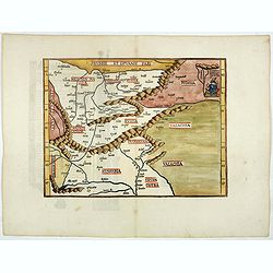
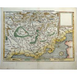
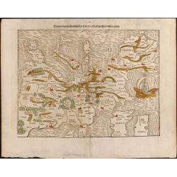
(Untitled map) Prussie et Lituanie Pars, Polonia, Russia, Transilvania, . . .
Early woodcut map of the area of Eastern Europe from Lithuania and Prussia in the north to Hungary and Valachia in the south. It also includes Transylvania, Russia. Polan...
Place & Date: Strasbourg, 1522
Selling price: $750
Sold in 2018
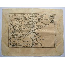
Tabu Moderna Hungariae, Poloniae, Russiae, Prussiae, et Valachiae.
A wood cut engraved map of modern day Hungary, Poland, Russia, Prussia and Romania on Ptolemaic projection from "Geographia", with maps by Laurens Fries and the...
Place & Date: Strassburg, 1522 -1525
Selling price: $500
Sold in 2019
Tabula Moderna Hiber.
One of the Earliest obtainable Modern Maps of the British Isles. A nice example of the 1525 edition of Lorenz Fries's double-page woodblock modern map of the British Isl...
Place & Date: Strasbourg, 1525
Selling price: $1300
Sold in 2021
![Tabula III Asiae. [Caucass and Armenia.]](/uploads/cache/47571-250x250.jpg)
Tabula III Asiae. [Caucass and Armenia.]
Ptolemaic map of the region south of the Caucasus Mountains and between the Caspian Sea as far south as the headwaters of the Tigris River in the south and the Black Sea,...
- $750 / ≈ €702
Place & Date: Lyons, M. Servetus, 1525
![[Map of the British Isles]](/uploads/cache/40500-250x250.jpg)
[Map of the British Isles]
First edition Inghilterra.Rare: A very early woodblock map of the British Isles by the Italian cartographer Benedetto Bordone, an 16th century illuminator and wood engrav...
Place & Date: Venice, 1528
Selling price: $650
Sold in 2017
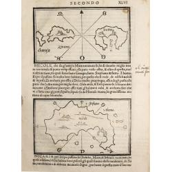
Charusa, Zinara Levita / Micole / (on verso) Stapodia and Nicaria.
Benedetto Bordone (1460-1531), cartographer and engraver. Published in 1528 his islands book, 'Isolario'.Three maps from Bernadetto Bordone?s ?Isolario?.
Place & Date: Venice, 1532
Selling price: $150
Sold
(Morea / Peloponnese peninsula)
Very early map of the Peloponnese peninsula, naming several towns and smaller islands. Published in Bordone's important "Isolario". Italian text below the map a...
Place & Date: Venice, c1534
Selling price: $110
Sold in 2014
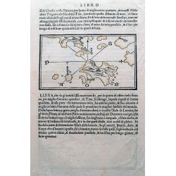
(Istria, Lošinj, Krk, Cres, Rab; Vis)
One of the earliest maps showing Croatian (Dalmatian) islands in the Adriatic Sea. Wood cut with italian text on both sides, and with a map on each side. One map, with a ...
Place & Date: Venice, c1534
Selling price: $50
Sold in 2015
![[Taurica]](/uploads/cache/37038-250x250.jpg)
[Taurica]
In 1528 the Italian cartographer Benedetto Bordone (1460-1531) produced an atlas of islands. The interior of the island is depicted as mountainous with symbols for severa...
Place & Date: Venice, 1534
Selling price: $190
Sold in 2023
![[Taurica chersoneso]](/uploads/cache/37105-250x250.jpg)
[Taurica chersoneso]
In 1528 the Italian cartographer Benedetto Bordone (1460-1531) produced an atlas of islands. An early, crude, but also fascinating small map depicting the region around C...
Place & Date: Venice, c 1534
Selling price: $95
Sold in 2016
![[Map of Russia]](/uploads/cache/30113-250x250.jpg)
[Map of Russia]
Early map of part of Russia, centered on Smolensk, Riga, Moscow and other major cities are mentioned, also the rivers Dvina, Volga, engraved by Sebastian Münster. From P...
Place & Date: Basel, 1538
Selling price: $900
Sold in 2010
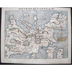
Europae Tabula
At the time Sebastian Münster published this map, it was not yet conventional to locate the North at the top of the map. Münster‘s orientation to the South was taken ...
Place & Date: Basle, 1540
Selling price: $800
Sold in 2015
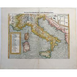
Italia mit Dreien furnemsten Inseln, Corsica, Sardinia und Sicilia.
One of the earliest woodcut maps of Italy by Sebastian Münster. Showing Italy with the Islands Sardinia, Sicily and Corsica. With Dalmatia in the East. The title on vers...
Place & Date: Basle, ca 1540
Selling price: $250
Sold in 2019
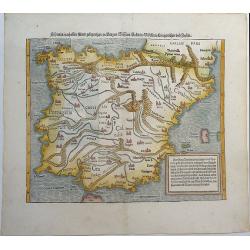
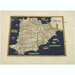
Hispania nach aller seiner gelegenheit, in Bergen, Wassern, Stetten, Volckern, Künigreichen und Inseln.
One of the earliest woodcut maps of Spain and Portugal by Sebastian Münster. Attractively colored and with the islands Majorca and Minorca. The title on verso is surroun...
Place & Date: Basel, ca 1540
Selling price: $190
Sold in 2019
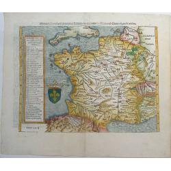
Das gantz Franckreich, so vor zeiten Gallia Narbonensis, Lugdunensis, Belgica und Celtica ist genent worden.
One of the earliest maps of France by Sebastian Münster. With the southern part of England. The title on verso is surrounded by a large and beautiful woodcut border. Fro...
Place & Date: Basel, ca 1540
Selling price: $235
Sold in 2019
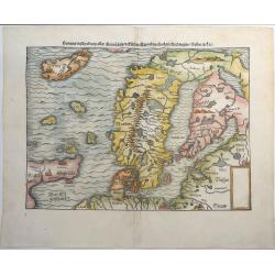
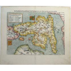
Gemeine Beschreibung Aller Mitnachtigen Lander Schweden, Gothen, Nordwegien, Dennmarck &c.
One of the earliest woodcut maps of Scandinavia. Shows Iceland, Norway, Sweden, Finland, Scotland, Denmark with the North Sea and Baltic Sea. Sebastian Munster's second m...
Place & Date: Basel, ca 1540
Selling price: $325
Sold in 2019
TEÜTSCHLAND MIT SEINEM GANTZEN BEGRIFF UND EINGSCHLOSZNEN LANDSCHAFFTEN.
A very rare state of Europe or Germany by Sebastian Münster, unlike most maps of Germany from the Cosmographia. Attractively colored and oriented to the South. Showing t...
Place & Date: Basel, ca 1540
Selling price: $350
Sold in 2019
Das Kunigreich Engelland, mit dem anstossenden Reich Schottland, so vor zeiten Albion und Britannia, haben geheissen.
An early, unusual woodcut map of the British Isles, which is oriented to the East. Sebastian Munster's map was the first separately printed map of England and a landmark ...
Place & Date: Basel, ca 1540
Selling price: $375
Sold in 2019
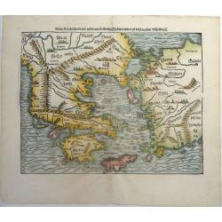
Neuw Griechenlandt, mit andern anstossenden Landern, wie es zu unsern zeiten beschriben ist.
An early woodcut map of Greece by Sebastian Münster. Showing Greece with western Turkey. The title on verso is surrounded by a beautiful woodcut border. From the German ...
Place & Date: Basel, ca 1540
Selling price: $175
Sold in 2019
Der Statt Parma abcontrafactur nach Ihrer gelgenheit.
A large, early woodcut view of Parma by Sebastian Munster on the full double sheet. Title and a description of the city on verso. This interesting view of Parma depicts t...
Place & Date: Basel, ca 1540
Selling price: $150
Sold in 2019
EUROPAE Tabula Quinta continet Rhetiam et Vindeliciam?
A Ptolemaic map of the Dalmatian coast but also showing parts of Italy, and the northern tip of Corsica. ¤
Place & Date: Vienne, 1541
Selling price: $400
Sold in 2009
ASIAE TABULA secunda continet.
This is a Ptolemaic version of the Black Sea, Ukraine and Southern Russia areas extending to the Caspian Sea. The Crimean Penninsula is shown, lower left, and the Russian...
Place & Date: Vienne, 1541
Selling price: $800
Sold in 2019
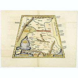
![Europae Tabula quarta continet. [Central Europe]](/uploads/cache/15350-250x250.jpg)
Europae Tabula quarta continet. [Central Europe]
The earliest printed representation of Germany, Poland and central Europe.
Place & Date: Vienne 1541
Selling price: $400
Sold in 2008
Aphricae tabula secunda continet
Untitled trapezoidal Ptolemaic woodcut map of North Africa. From the 1541 Vienne (Dauphiné) edition of Ptolemy\'s Geographia published by Gaspar Trechsel and sold by H...
Place & Date: Vienne, 1541
Selling price: $500
Sold in 2009
Europae Tabula secunda : Continet Hispaniam Baeticam, Hispaniam Lusitaniam& Hispaniam Tarraconensem .
Map of Spain and Portugal prepared by C. Ptolemy (0100?-0170?) and edited by Michel Servet (1511-1553).Included in "Claudii Ptolemaei Alexandrini geographicae enarra...
Place & Date: Lyon, M. Servetus, 1541
Selling price: $950
Sold in 2011
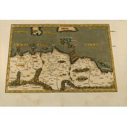
![[Greece]](/uploads/cache/33846-250x250.jpg)
[Greece]
Wood block printed map and one of earliest printed representation of Greece prepared Martin Waldseemüller.Based on the slightly larger map from 1513 published in "P...
Place & Date: Vienna, Trechsel, G., 1525 -1541
Selling price: $1050
Sold in 2013
![[Spain and Portugal]](/uploads/cache/33848-250x250.jpg)
[Spain and Portugal]
Wood block printed map and one of earliest printed representation of Spain and Portugal prepared Martin Waldseemüller.Based on the slightly larger map from 1513 publishe...
Place & Date: Vienna, Trechsel, G., 1525 -1541
Selling price: $500
Sold in 2013
![[Great Britain, Ireland]](/uploads/cache/33865-250x250.jpg)
[Great Britain, Ireland]
Wood block printed map and one of earliest printed representation of the Great Britain and Ireland prepared Martin Waldseemüller. Based on the slightly larger map from 1...
Place & Date: Vienna, Trechsel, G., 1525 -1541
Selling price: $750
Sold in 2013
![[Czech Republic, Germania, Germany, Poland]](/uploads/cache/33866-250x250.jpg)
[Czech Republic, Germania, Germany, Poland]
Wood block printed map and one of earliest printed representation of Czech Republic, Germania, Germany, Poland prepared Martin Waldseemüller. River Rhine to the left. Ba...
Place & Date: Vienna, Trechsel, G., 1525 -1541
Selling price: $750
Sold in 2014
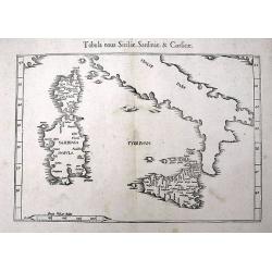
Tabula nova Siciliae, Sardiniae, & Corsicae
An early woodcut Ptolemaic map of Corsica, Sardinia, Sicily, and southern Italy. With several towns and islands named. The active volcano Etna is shown with flames.
Place & Date: Vienne, 1541
Selling price: $120
Sold in 2016
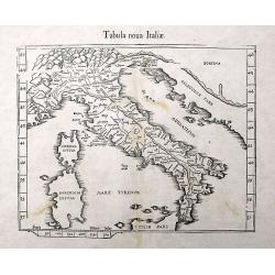
Tabula nova Italiae.
One of the earliest modern maps of Italy after Claudius Ptolemy, based on Waldseemuller. Shows Italy with ancient place names, rivers, and a prominent display of the moun...
Place & Date: Vienne or Lyon, 1541
Selling price: $215
Sold in 2016
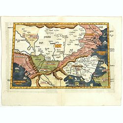
Europae Tabula Decima continent (Title on verso)
Attractive woodblock Ptolemaic map showing south east Europe from the Adria to the black sea with Albania, Mazedonia, North-Greece to the Bosporus. Some detail of Turkey ...
Place & Date: Strasbourg 1541
Selling price: $350
Sold in 2019
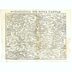
Franconia XII Nova Tabula.
Detailed regional map of Germany, centered on Bamberg and the Mein River. One of the earliest obtainable modern maps of the region. From the 1542 edition of Münster's Ge...
Place & Date: Basle, ca. 1542
Selling price: $50
Sold in 2017
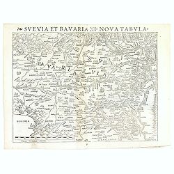
Svevia et Bavaria XII, Nova Tabula.
A highly decorative woodcut map by famous mapmaker Sebastian Münster published in his Ptolemy edition 1552 in Basel at Heinrich Petri. The decorative woodcut bordures ve...
Place & Date: Basle, ca. 1542
Selling price: $50
Sold in 2016
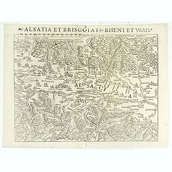
Alsatia et Brisgoia II Rheni Et VII Nova Tabula.
Detailed map of the Rhine River Valley, from Strasburg and Argentina to Basel and Laufenberg, centered on Brisach and Kappel and showing Colmar. West is at the top of the...
Place & Date: Basle, ca. 1542
Selling price: $60
Sold in 2019
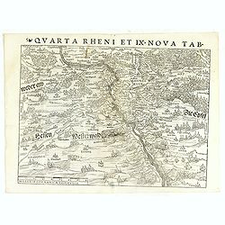
Quarta Rheni et IX Nova Tab.
Highly detailed regional map of the course of the Rhine, from Mainz to Bonn, one of the first obtainable modern maps of the region. Extremely detailed for the period. The...
Place & Date: Basle, ca. 1542
Selling price: $135
Sold in 2017
Leyden / Alva.
Very early panoramic view of Leiden. Size of the sheet is 360x232mm. From his Geographia , that great compendium of Renaissance knowledge. An exciting print.
Place & Date: Basle 1544
Selling price: $90
Sold
's-Hertogenbosch / Antwerp / Alva.
Very early panoramic view of 's-Hertogenbosch and Antwerp. Size of the sheet is 334x222mm. From his Geographia , that great compendium of Renaissance knowledge. An exciti...
Place & Date: Basle 1544
Selling price: $50
Sold
Leyden/ Alva
Very early panoramic view of Leiden. Size of the sheet is 360x232mm. From a German text edition of his Geographia , that great compendium of Renaissance knowledge.The Cos...
Place & Date: Basle, 1544
Selling price: $40
Sold in 2010
's-Hertogenbosch and Mechelen.
Very early panoramic views of 's-Hertogenbosch and Mechelen. Size of the sheet is 364x235mm.From his Geographia , that great compendium of Renaissance knowledge.
Place & Date: Basle, 1544
Selling price: $80
Sold in 2010
![[Map of Caspian Sea and Europe]](/uploads/cache/31512-250x250.jpg)
[Map of Caspian Sea and Europe]
Page with an early representation of the Caspian Sea and on verso a map of Europe. This text page with a fine wood block printed map is from the rare work "C. Iulii ...
Place & Date: Basle, Michael Isengrin, 1544
Selling price: $210
Sold in 2011
![[Map of Caspian Sea and Europe]](/uploads/cache/31513-250x250.jpg)
[Map of Caspian Sea and Europe]
Page with an early representation of Germany. This text page with a fine wood block printed map is from the rare work "C. Iulii Solini Polyhistor, Rerum Toto Orbe Me...
Place & Date: Basle, Michael Isengrin, 1544
Selling price: $50
Sold in 2011
![[Map of Italy]](/uploads/cache/31509-250x250.jpg)
[Map of Italy]
Page with an early representation of Italy with Sicily, Sardinia and Corsica. South to the top. This text page with a fine wood block printed map is from the rare work &q...
Place & Date: Basle, Michael Isengrin, 1544
Selling price: $450
Sold in 2011
![[Plan of Rome]](/uploads/cache/31510-250x250.jpg)
[Plan of Rome]
Page with an early representation of Rome. This text page with a fine wood block printed map is from the rare work "C. Iulii Solini Polyhistor, Rerum Toto Orbe Memor...
Place & Date: Basle, Michael Isengrin, 1544
Selling price: $142
Sold in 2011
![[Map of Morea]](/uploads/cache/31508-250x250.jpg)
[Map of Morea]
Page with an early representation of the Greek Island of Morea. This text page with a fine wood block printed map is from the rare work "C. Iulii Solini Polyhistor, ...
Place & Date: Basle, Michael Isengrin, 1544
Selling price: $150
Sold in 2013
![[Map of Rhodes]](/uploads/cache/31507-250x250.jpg)
[Map of Rhodes]
Page with an early representation of the Greek Island of Rhodes. This text page with a fine wood block printed map is from the rare work "C. Iulii Solini Polyhistor,...
Place & Date: Basle, Michael Isengrin, 1544
Selling price: $60
Sold in 2018
![[Map of the central Europe with Switzerland]](/uploads/cache/31505-250x250.jpg)
[Map of the central Europe with Switzerland]
Page with an early representation of Central Europe with Switzerland, Austria. South to the top. This text page with a fine wood block printed map is from the rare work &...
Place & Date: Basle, Michael Isengrin, 1544
Selling price: $100
Sold in 2014
![[Map of Russia]](/uploads/cache/31506-250x250.jpg)
[Map of Russia]
Page with an early representation of Russia. This text page with a fine wood block printed map is from the rare work "C. Iulii Solini Polyhistor, Rerum Toto Orbe Mem...
Place & Date: Basle, Michael Isengrin, 1544
Selling price: $260
Sold in 2011
![[Map of the England]](/uploads/cache/31504-250x250.jpg)
[Map of the England]
Page with an early representation of the British Isles. This text page with a fine wood block printed map is from the rare work "C. Iulii Solini Polyhistor, Rerum To...
Place & Date: Basle, Michael Isengrin, 1544
Selling price: $475
Sold in 2011
![[Map of Ukrania]](/uploads/cache/31494-250x250.jpg)
[Map of Ukrania]
Page with an early representation of Ukrania with the Black Sea. This text page with a fine wood block printed map is from the rare work "C. Iulii Solini Polyhistor,...
Place & Date: Basle, Michael Isengrin, 1544
Selling price: $275
Sold in 2011
![[Map of Sicily]](/uploads/cache/31492-250x250.jpg)
[Map of Sicily]
Page with an early representation of Sicilia and the south of Italia. This text page with a fine wood block printed map is from the rare work "C. Iulii Solini Polyhi...
Place & Date: Basle, Michael Isengrin, 1544
Selling price: $600
Sold in 2011
![[Map of Greece]](/uploads/cache/31493-250x250.jpg)
[Map of Greece]
Page with an early representation of Greece. This text page with a fine wood block printed map is from the rare work "C. Iulii Solini Polyhistor, Rerum Toto Orbe Mem...
Place & Date: Basle, Michael Isengrin, 1544
Selling price: $100
Sold in 2016
![[Map of Europe]](/uploads/cache/31463-250x250.jpg)
[Map of Europe]
Page with an early representation of Europe. The continent is filled with the Alps mountains and the rivers Rhine and Danube.This text page with a fine wood block printed...
Place & Date: Basle, Michael Isengrin, 1544
Selling price: $500
Sold in 2011
's-Hertogenbosch and Mechelen
Very early panoramic view of 's-Hertogenbosch and Mechelen. Size of the sheet is 364x235mm. From his Geographia, that great compendium of Renaissance knowledge.
Place & Date: Basle, ca. 1544
Selling price: $25
Sold in 2012
![[Map of Europe]](/uploads/cache/31501-250x250.jpg)
[Map of Europe]
Page with an early representation of Europe. This text page with a fine wood block printed map is from the rare work "C. Iulii Solini Polyhistor, Rerum Toto Orbe Mem...
Place & Date: Basle, Michael Isengrin, 1544
Selling price: $225
Sold in 2013
Heidelberg.
One of the two largest woodcuts from the 'Cosmographia' by Sebastian Münster. This is the attractively colored bird-eye view of Heidelberg. It is highly detailed, with a...
Place & Date: Basel, 1544
Selling price: $190
Sold in 2019
Von dem Europa, das zu unsern zeiten die Christenheit under im begreifft und etwas von der Türkey.
An attractive map of Europe from the famous 'Cosmographia' by Sebastian Münster, in very nice colors. Europe has almost already taken the shape of Regina Europa. On ve...
Place & Date: Basel, 1544
Selling price: $100
Sold in 2022
Europa, das ein Drittheil der Erden, nach gelegenheit unsern zeiten
Attractive woodcut map showing the European continent with South on top. From a German edition of Cosmographia by Sebastian Munster printed from Petri in Basel around 154...
Place & Date: Basle, 1545
Selling price: $500
Sold in 2009
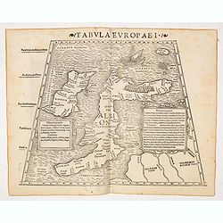
Tabula Europae I (Great Brittain)
The first edition of Munster's Ptolemaic map of Great Britain appeared in his "Geographia Universalis", first published in 1540. This was a new and important ed...
Place & Date: Basel, Heinrich Petri, 1545
Selling price: $540
Sold in 2014
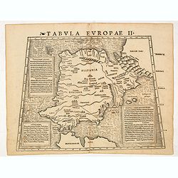
Tabula Europae II (Spain and Portugal)
The first edition of Munster's Ptolemaic map of Spain and Portugal appeared in his "Geographia Universalis", first published in 1540. This was a new and importa...
Place & Date: Basel, Heinrich Petri, 1545
Selling price: $350
Sold