Browse Listings in Europe
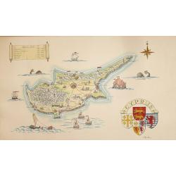
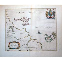
A Pictorial Map of Cyprus.
An attractive hand painted map of Cyprus a scroll cartouche has the Historical dates of the Islands occupation, the map centers on Nicosia. The sea has galleons, sea mons...
Date: ca. 1950
Selling price: ????
Please login to see price!
Sold in 2014
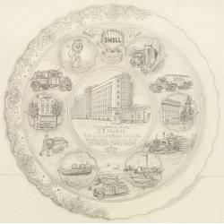
Shell : 9 Februari 1911-1951.
Decorative design-drawing in lead pencil offered to mr. J.E. Talens for his 40 years jubilee at the Shell foundation : Aangeboden aan J. E. Talens ter gelegenheid van zij...
Date: Gouda, ca. 1951
Selling price: ????
Please login to see price!
Sold in 2025

1953 Harry Beck London Underground map.
Published in the Queen's coronation year. A London Underground map (double sided).
Date: London, 1953
Selling price: ????
Please login to see price!
Sold in 2019

1953 Harry Beck London Underground map.
1953 - The Queen's coronation year. London Underground map (double sided).
Date: London, 1953
Selling price: ????
Please login to see price!
Sold in 2017

(1953 Harry Beck London Underground map.)
1953 - The Queen's coronation year. London Underground map (double sided) .
Date: London, 1953
Selling price: ????
Please login to see price!
Sold in 2017

1953 Harry Beck London Underground map.
1953 - The Queen's coronation year. London Underground map (double sided).
Date: London, 1953
Selling price: ????
Please login to see price!
Sold in 2017
![[London Underground map 1953]](/uploads/cache/82683-250x250.jpg)
[London Underground map 1953]
1953 Queens Corination Year London Underground map
Date: London, 1953
Selling price: ????
Please login to see price!
Sold in 2019
![[London Underground map 1953]](/uploads/cache/47164-250x250.jpg)
[London Underground map 1953]
1953 Queens Corination Year London Underground map by Harry Beck. Abandoning the restrictions of a geographically correct layout, the map actually constitutes a diagram o...
Date: London, 1953
Selling price: ????
Please login to see price!
Sold in 2021
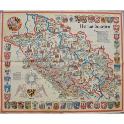
Heimat Schlesien.
A large map of Silesia surrounded by 42 coats of arms. Finely illustrated cities and towns. A very decorative item.
Date: Stuttgart, ca 1955
Selling price: ????
Please login to see price!
Sold in 2020
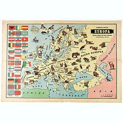
Europa - Grande Atlante dei Paesi d'Europa Ventiduesima Tavola.
Pictorial map of Europe, showing wild animals living in each country. On verso Italian text and photo's.
Date: Italy, 1956
Selling price: ????
Please login to see price!
Sold in 2020
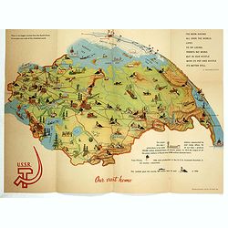
Our vast home.
Propaganda folder with pictorial map of Russia, published for Brussels Universal and international exhibition, 1958. This World exhibition was held April 17 through Octob...
Date: U.S.S.R., 1958
Selling price: ????
Please login to see price!
Sold in 2017
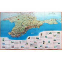
MAP OF CRIMEA
Large illustrated tourist-map of Crimea, with a beautiful representation of the topographic features of the peninsula. Published by the Office of Geodesy and Cartography ...
Date: Moscow, 1963
Selling price: ????
Please login to see price!
Sold in 2012
![[Travel in Five Soviet Republics by Car].](/uploads/cache/44797-250x250.jpg)
[Travel in Five Soviet Republics by Car].
A nicely presented Russian route planner from Moscow in the Soviet Union to (Talin) Estonia, (Riga) Latvia, (Vilnius) Lithuania and (Minsk) Belarus. Inside front cover ha...
Date: Moscow, 1963
Selling price: ????
Please login to see price!
Sold in 2019
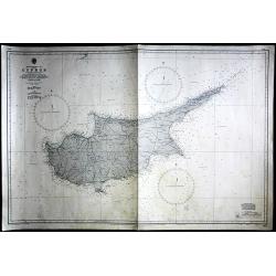
Cyprus
Large Admiralty sea chart of Cyprus.
Date: London, 1964
Selling price: ????
Please login to see price!
Sold in 2017
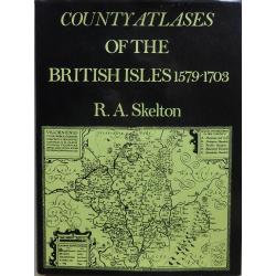
County Atlases Of The British Isles 1579-1703.
A most informative reference book. Cloth bound with dust jacket 250 pages plus illustrations and figures. The definitive carto-bibliography. Published in 1970 by Carta Pr...
Date: London, 1970
Selling price: ????
Please login to see price!
Sold in 2017
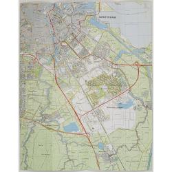
Nederland 1 : 25.000 Blad 25D Amstelveen.
Folding-map of southern part of Amsterdam, Amsterdam Zuid-Oost , Ouderkerk aan de Amstel, Abcoude and part of Amstelveen. First edition in 1977, then corrected in 1981 by...
Date: Netherlands, 1977, revised 1981
Selling price: ????
Please login to see price!
Sold in 2009
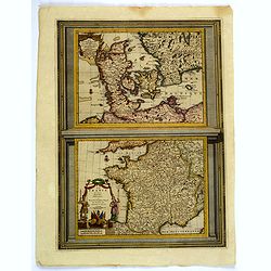
Le Danemarc. . . / La France. . .
A very nice pair of European maps, one the single plate by Pierre Van der Aa. Top map is that of Denmark, with grid lines, compass rose, mileage scales and a decorative t...
Date: Leiden, 1713-29
Selling price: ????
Please login to see price!
Sold in 2019
![Hardales in Hispanien. [Ardales]](/uploads/cache/11365-250x250.jpg)
Hardales in Hispanien. [Ardales]
View of the city of Ardales, northwest of Malaga. With a verse in two languages underneath the picture.The poet Daniel Meisner from Komotau started his Thesaurus Philo-Po...
Date: Frankfurt 1623-78
Selling price: ????
Please login to see price!
Sold
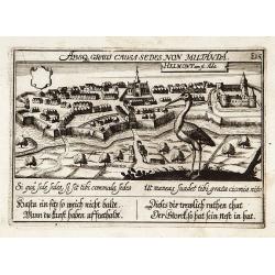
Helmond.
"View of the town with in the foreground a large stork. With a verse in two languages underneath the picture.The poet Daniel Meisner from Komotau started his Thesaur...
Date: Frankfurt 1623-78
Selling price: ????
Please login to see price!
Sold
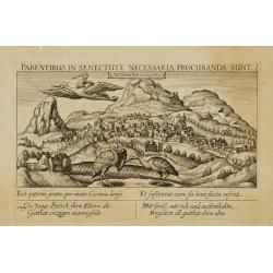
Archidona in Hispania.
View of the Spanish city of Archidona in Andalusia. With a verse in two languages underneath the picture.The poet Daniel Meisner from Komotau started his Thesaurus Philo-...
Date: Frankfurt 1623-78
Selling price: ????
Please login to see price!
Sold in 2009
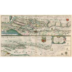
Celeberrimi Fluvii Albis nove delineation.
Hamburg area & Elbe river by Blaeu. Latin text on verso.
Date: Amsterdam, 1644-45
Selling price: ????
Please login to see price!
Sold in 2010
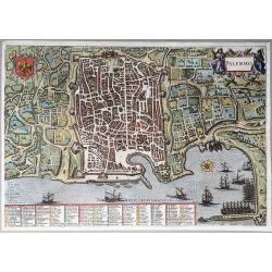
Palermo.
A colored bird's eye view of the city of Palermo on Sicily, depicted in its defense works surrounded by fields, as seen from the North. The city's coat of arms at the top...
Date: Leiden, 1715-1725
Selling price: ????
Please login to see price!
Sold in 2022
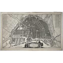
Plan de la grande & fameuse ville marchande d'Amsterdam / Plan de la grande & fameuse ville marchande d'Amsterdam
A very large size city map of Amsterdam within its fortifications is seen from the IJ, with main buildings depicted in bird's eye view, and many ships moored or in the ha...
Date: Amsterdam, ca. 1725/35
Selling price: ????
Please login to see price!
Sold in 2022
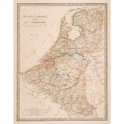
Belgium and Holland, late the Km. of the Netherlands.
"Very detailed map of the Netherlands, Belgium and Luxembourg. Indicated are railways, canals and battlefields by date.James Wyld (the younger) was geographer to the...
Date: London 1855/64
Selling price: ????
Please login to see price!
Sold
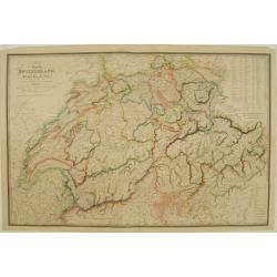
Map of the Republic Switzerland, describing its 22 cantons.
Very detailed map of Switzerland. Upper right hand corner geographical notes, lower left, explanations of the signs.James Wyld (the younger) was geographer to the Queen a...
Date: London 1855/64
Selling price: ????
Please login to see price!
Sold
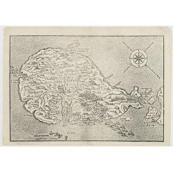
Mandria, Fornoli, Lipso and Cruscia /.(verso) Lango.
Benedetto Bordone (1460-1531), cartographer and engraver. Published in 1528 his islands book, 'Isolario'.Two woodcut maps from Bernadetto Bordone?s ?Isolario?.
Date: Venice, 1532.
Selling price: ????
Please login to see price!
Sold
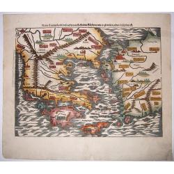
Neuw Griechenlandt, mit andern. . .
A nice full color example of Münster's first map of modern Greece, from Munster's 'Cosmographia', one of the most influential geographical works of the 16th century. Dat...
Date: Basel, ca 1550
Selling price: ????
Please login to see price!
Sold in 2020
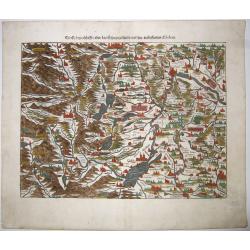
Die Eydtgnoschafft,oder das Schwytzerlandt. . .
An antique map of Switzerland and the source of the Rhine, by Sebastian Munster.One of the Earliest Modern Maps of Switzerland. This map is also the first of the 3 sheets...
Date: Basel, ca 1550
Selling price: ????
Please login to see price!
Sold in 2020
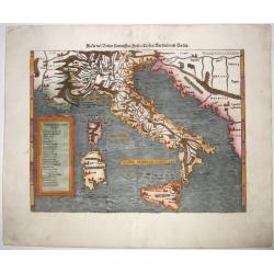
Italia mit Dreien Fuernemsten Inseln, Corsica, Sardinia, Sicilia.
A fine woodblock map of Italy by Münster, from a 1550's German edition of his 'Cosmography'. A map covering all of Italy, Sicily, Corsica and Sardinia, showing the river...
Date: Basel, ca 1550
Selling price: ????
Please login to see price!
Sold in 2020
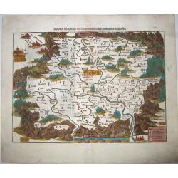
Teutschland,mit seinem gantzen begriff und eingeschlossnen Landschafften.
A fine antique woodcut map of Germany by Sebastian Münster, ca 1550, Basel. From a German edition of his 'Cosmography'.Germany, with parts of the Netherlands, Austria, S...
Date: Basel, ca 1550
Selling price: ????
Please login to see price!
Sold in 2020
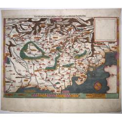
SCLAVONIA ODER WINDISCH MARCK. . .
A detailed and attractive wood block map by Munster of the region that included Istria and extends to include some of Slovenia, Croatia, Dalmatia, and northeastern Italy....
Date: Basel, ca 1550
Selling price: ????
Please login to see price!
Sold in 2021
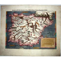
HISPANIA. . .
Sebastian Münster's highly influential modern map of the Iberian peninsula. The first state, second issue, one of the earliest obtainable modern maps of Spain and Portug...
Date: Basel, ca 1550
Selling price: ????
Please login to see price!
Sold in 2021
Behemer Koenigreich. . .
Münsters first map [of 2] of Bohemia, published in Basel, circa 1550. An early woodcut map of Bohemia, (Czech Republic) by Sebastian Münster oriented to the South. The ...
Date: Basel, ca 1550
Selling price: ????
Please login to see price!
Sold in 2021
![Die Siebenbürg. . .Transylvania,Romania]](/uploads/cache/85024-250x250.jpg)
Die Siebenbürg. . .Transylvania,Romania]
Münsters first map [of 2] of Bohemia, published in Basel, circa 1550. An early woodcut map of Transylvania, Romania by Sebastian Münster oriented to the North. The titl...
Date: Basel, ca 1550
Selling price: ????
Please login to see price!
Sold in 2021
![L'effigie de la ville de Saleurre. . . [Solothurn]](/uploads/cache/85032-250x250.jpg)
L'effigie de la ville de Saleurre. . . [Solothurn]
A fine (woodcut) panoramic town-view of Solothum with the River Aar in the foreground. In lower right CS. There is no information available for the monogamist CS, however...
Date: Basel, ca 1550
Selling price: ????
Please login to see price!
Sold in 2021
![LA VILLE DE CHOURES. . .[Chur]](/uploads/cache/85033-250x250.jpg)
LA VILLE DE CHOURES. . .[Chur]
A fine woodcut panoramic view of Chur, by Sebastian Muenster, ca. 1550. Chur is the oldest town in Switzerland and the capital of the Canton of Graubünden/Grisons. Chur ...
Date: Basel, ca 1550
Selling price: ????
Please login to see price!
Sold in 2021
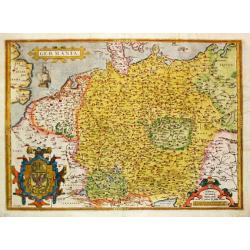
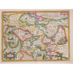
Germania. . .
A map of Germany from Abraham Ortelius’ "Theatrum Orbis Terrarum" is probably based on the map by Christaan Sgrooten. Embellished with a large title-cartouche...
Date: Antwerp, 1571.
Selling price: ????
Please login to see price!
Sold in 2021
![Rhetiae alpestris descriptio in qua hodie Tirolis Comitatus [with] Goritiae, Karstii, Chaczeolae, Carniolae, Histriae, et Windorum Marchae Descrip.](/uploads/cache/99693-250x250.jpg)
Rhetiae alpestris descriptio in qua hodie Tirolis Comitatus [with] Goritiae, Karstii, Chaczeolae, Carniolae, Histriae, et Windorum Marchae Descrip.
Depicts two maps by Abraham Ortelius. A map of Tyrol, Austria is seen on the left while an example of Northern Yugoslavia is on the right.Both are rendered in lovely orig...
Date: Antwerp, 1580
Selling price: ????
Please login to see price!
Sold in 2010
![Baden im Argow. Baden Argoiae. [Baden]](/uploads/cache/84274-250x250.jpg)
Baden im Argow. Baden Argoiae. [Baden]
A map of Baden in Switzerland, published by Merian and his heirs in various works, including the Archontologia cosmica, Theatrum Europaeum and the Topographia Germaniae. ...
Date: Frankfurt, 1646 ca
Selling price: ????
Please login to see price!
Sold in 2020
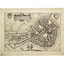
Berge op Zoom.
From Ludovico Guicciardini.'s description of the Netherlands ' Beschrijvinghe van alle de Nederlanden anderssins ghenoemt Neder-Duytslandt ', published by Willem Blaeu.A ...
Date: Amsterdam, W.Blaeu, 1612.
Selling price: ????
Please login to see price!
Sold
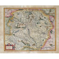
HUNGARIA Per Gerardum Mercatorem
This is Mercator's map of the Kingdom of Hungary. The Danube River runs through the map from the top left to the bottom right. Transylvania borders the map on the righ...
Date: Duisburg and later Amsterdam, (1585-95) 1613
Selling price: ????
Please login to see price!
Sold in 2012
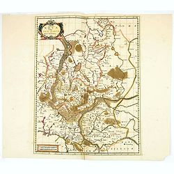
MARCA BRANDEBURGENSIS & POMERANIA.
Gerard Mercator (1512-94). His 'Atlas sive Cosmographica' was posthumously published in 1595. Jodocus Hondius (1563-1612), a founder of the Hondius publishing house, acqu...
Date: Amsterdam, 1613.
Selling price: ????
Please login to see price!
Sold
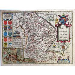
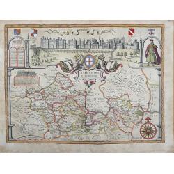
The Countie and Citie of Lyncolne described with the Armes of Them That Have Bene Earles thereoe since the conquest.
“The Countie and Citie of Lyncolne described with the Armes of Them That Have Bene Earles thereoe since the conquest”. English county map by John Speed. The plates we...
Date: London, 1614
Selling price: ????
Please login to see price!
Sold in 2020
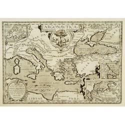
Argonautica.
A very nice map of Greece. Very decorative title cartouche centred in the upper part of the map. Three inset maps in upper left-hand corner and lower-right-hand corner, i...
Date: Antwerp 1603-1618.
Selling price: ????
Please login to see price!
Sold

Philippus III. Dei Gratia Hispaniarum Et Indiarum Rex etc.
The engraving depicts a half length oval portrait of Philip III of Spain.Nicolaes de Clerck (de Klerc) was active as engraver and publisher in Delft from 1599-1621.Includ...
Date: Amsterdam, Cloppenburch, 1621.
Selling price: ????
Please login to see price!
Sold
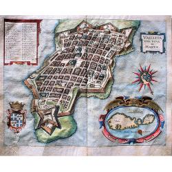
Valletta Citta Nova di Malta.
A fine, early map of Valletta, the capital of Malta. A very detailed view of the city with 41 locations of important buildings and locations. It includes a large inset ma...
Date: Frankfurt am Mains, 1636
Selling price: ????
Please login to see price!
Sold in 2017
Insula Sacra; Vulgo Holy Iland; Et Farne.
Attractive map of Holy and Farne Islands off the coast of Northumberland. Farne Island is shown with the Tower and on Holy Island a fort and abbey are visible. The mainla...
Date: Amsterdam, 1646.
Selling price: ????
Please login to see price!
Sold in 2012
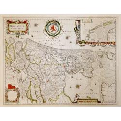
Hollandia Comitatus.
French text verso. Highly detailed regional map of Holland, showing the area around Amsterdam, Utrecht, Rotterdam, with an inset upper right corner of the Dutch Islands o...
Date: Amsterdam, 1647
Selling price: ????
Please login to see price!
Sold in 2016
Delineatio Situsve Provinciae Clissam & spalatum. Abbildung oder Situation der Landschafft Clissa vnd Spalato.
An important copper engraving from Merian's Theatrum Europäum, 1652 (see Fauser Nr. 13238). It shows a bird's-eye view of the region of Split with the islands of Solta u...
Date: Frankfurt a. M., 1654
Selling price: ????
Please login to see price!
Sold in 2019
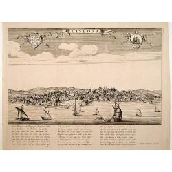
Lisbona.
A rare panoramic view of Lisbon with over the whole length of the lower part 3 columns of poems in Latin, Dutch and French.Published by Dancker Danckerts (1634-1666)Colle...
Date: Amsterdam, 1660.
Selling price: ????
Please login to see price!
Sold
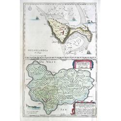
Helgolandia A o. 1649. / Helgoladt in annis Christi 800, 1300 & 1649. Johannnes Mejerus Husum.
Johan Blaeu succeeded his father Willem when the latter died in 1638. Johan led the Blaeu firm to its greatest achievement, the 'Atlas Maior' in 12 parts, the greatest an...
Date: Amsterdam, 1662,
Selling price: ????
Please login to see price!
Sold
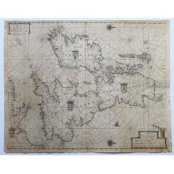
Pas-Caart vant Canaal Vertoonende in 't Gheheel Engelandt, Schotlandt, Yrlandt, en een Gedeelte van Vrancryck.
A fine chart of the British Isles. North is oriented to the right. Embellished with two compass roses, a galleon under sail and four national coats of arms. This chart ap...
Date: Amsterdam, 1665-1666.
Selling price: ????
Please login to see price!
Sold in 2020
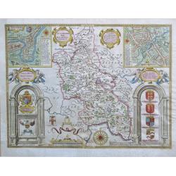
Buckinghamshire.
An attractive map of Buckinghamshire from the "Theatre of Great Britaine" by John Speed, published by Thomas Bassett and Richard Chiswell with two interesting i...
Date: London, 1676
Selling price: ????
Please login to see price!
Sold in 2020
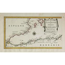
Les Costes des Royaumes de Fez, Alger, Tunis et Tripoli en Barbarie. 1677.
Piere du Val (1618-83), Paris-based cartographer and publisher. Atlases a.o. ' Cartes de Géographie', 1654-88, ' La Géographie universelle' , 1661-1712. After his death...
Date: Paris, 1688.
Selling price: ????
Please login to see price!
Sold in 2014
Marchia Nova Vulgo New Marck in March Brandenburg.
Hand-colored copper engraving by Moses Pitt and Stephan Swart. Published in Amsterdam, 1695.
Date: Amsterdam, 1695.
Selling price: ????
Please login to see price!
Sold in 2020
Castra Suedica ad Fridirici Uddam.
From Pufendorf's famous chronicle on the Baltic area, ' Histoire du règne de Charles Gustave, roy de Suède'The Swedish fortifications in front of Fredericia, 1657.
Date: Nürnberg, C. Riegel, 1697.
Selling price: ????
Please login to see price!
Sold in 2008
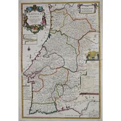
Le Portugal.
Le Père Placide de Sainte-Hélène was the brother-in-law of Pierre Duval. After the death of Duval his widow continued the firm.A large map of Portugal, with an inset o...
Date: Paris, c. 1700.
Selling price: ????
Please login to see price!
Sold in 2013
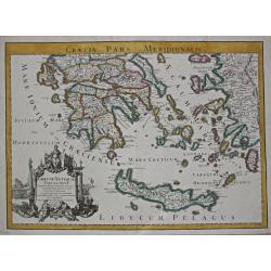
Graecia Antiquae Tabula Nova / Pars Meridionalis.
Guillaume de l' Isle (1675-1724), Royal Geographer, was the most influential cartographer of the first quarter of the 18th century. ' Atlas de Géographie' (1700-12), pos...
Date: Paris, 1707.
Selling price: ????
Please login to see price!
Sold
BARKSHIRE DESCRIBED.
Original copperplate engraved map printed on handmade paper, with original hand coloring. A spectacular pictorial of WINDSOR CASTLE across the top of this decorative map....
Date: London, 1710
Selling price: ????
Please login to see price!
Sold in 2013
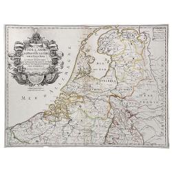
La Hollande ou les Provinces Unies des Pays Bas.
A copperplate border colored map of Holland. A scarce map of the 7 Provinces as published in Paris by Danet. Includes 7 coats of arms in the title cartouche.
Date: Paris, ca. 1720
Selling price: ????
Please login to see price!
Sold in 2019
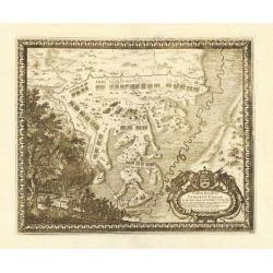
Accurate Carte der Uplandischen Scheren mit der Situation und Gegend umb die Konigle Schwedisch Haupt und Residentz Stadt Stockholm.
A decorative map and a pair of views, focusing on Stockholm and its environs. The map shows Stockholm and the area around it, focusing on the approach from the sea. The ...
Date: Nuremberg , ca 720
Selling price: ????
Please login to see price!
Sold in 2021
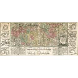
Cercle de Westphalie, suivant les nouvelles observations..
With decorative title cartouche upper left corner.This example is unusual in having the additional separately engraved decorative framework border around the map, the res...
Date: Amsterdam 1728.
Selling price: ????
Please login to see price!
Sold
La Frise, suivant les nouvelles observations..
With decorative title cartouche lower left corner.This example is unusual in having the additional separately engraved decorative framework border around the map, the res...
Date: Amsterdam 1728.
Selling price: ????
Please login to see price!
Sold
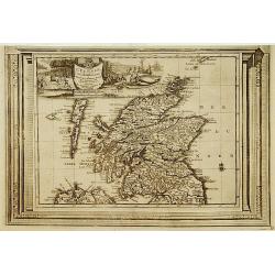
L'Ecosse, suivant les nouvelles observations..
With decorative title cartouche upper left corner.This example is unusual in having the additional separately engraved decorative framework border around the map, the res...
Date: Amsterdam 1728.
Selling price: ????
Please login to see price!
Sold
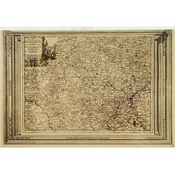
Le Duché de Luxembourg, suivant les nouvelles observations..
With decorative title cartouche upper left corner.This example is unusual in having the additional separately engraved decorative framework border around the map, the res...
Date: Amsterdam 1728.
Selling price: ????
Please login to see price!
Sold in 2009
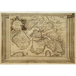
La Zelande, suivant les nouvelles observations..
With decorative title cartouche upper left corner.This example is unusual in having the additional separately engraved decorative framework border around the map, the res...
Date: Amsterdam 1728.
Selling price: ????
Please login to see price!
Sold
La Gueldre, suivant les nouvelles observations..
With decorative title cartouche lower left corner.This example is unusual in having the additional separately engraved decorative framework border around the map, the res...
Date: Amsterdam 1728.
Selling price: ????
Please login to see price!
Sold
Cercle de Bavière, suivant les nouvelles observations..
With decorative title cartouche upper right corner.This example is unusual in having the additional separately engraved decorative framework border around the map, the re...
Date: Amsterdam 1728.
Selling price: ????
Please login to see price!
Sold
Nieuwe Kaart van Europisch Turkyen.
Izaak Tirion (d.1769) Amsterdam publisher. His Nieuwe en beknopte handatlas saw 6 editions between before 1740 and after 1784. Also Tegenwoordige staat van alle volkeren,...
Date: Amsterdam, 1733.
Selling price: ????
Please login to see price!
Sold
![[RUSSIAN MAP] Battle of Stavuchany 1739.](/uploads/cache/85306-250x250.jpg)
[RUSSIAN MAP] Battle of Stavuchany 1739.
An extremely rare, large Russian single sheet map, of the plan of the battle of Stavuchany. Printed in Russian and German languages, possibly by the Academy of St.Petersb...
Date: St.Petersburg, ca 1739
Selling price: ????
Please login to see price!
Sold in 2021
Charte Geographique de la Campagne du Haut Rhin...
Large map by J.F. Oettinger on 2 sheets.
Date: Augsburg, 1740.
Selling price: ????
Please login to see price!
Sold in 2009
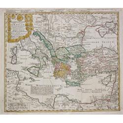
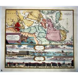
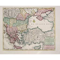
Imperii Turcici Europaei Tera in primis Graeciae.
Homann Heirs (of Johann Baptist and Johann Christof) published: Grosser Atlas, 1731, 1737. Geogr. Maior, 1759, Atlas Homannianus, 1762. A map showing the eastern Mediterr...
Date: Nurnberg, 1741.
Selling price: ????
Please login to see price!
Sold
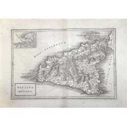
SICILIA ANTIQUA.
Attractive map of Sicily. Detailed with Rivers Mountains including Mt Etna erupting plus an inset map of Malta. From ‘Geographia Antiqua being a Complete Set of Maps of...
Date: London 1750
Selling price: ????
Please login to see price!
Sold in 2017
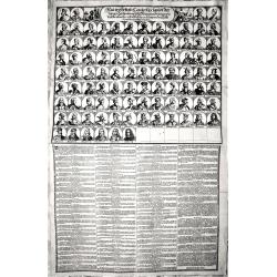
Neu verfertigte Conterfay sampt der Lebens-Beschreibung aller Könige in Spanien wie dieselbe einander ordentlich.. bis auf den jetzt Regierenden. (Karl III.)
Rare engraving depicting, in the upper part, all the kings of Spain till Carl III, in total it depicts 94 Kings.The lower part of the engravings describes each of them.Ra...
Date: Germany, around 1750
Selling price: ????
Please login to see price!
Sold in 2018
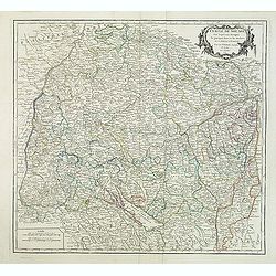
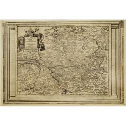
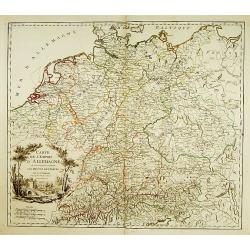
Cercle de Souabe. . .
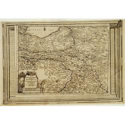
Finely and crisply engraved map of south part of Germany. Ornamental title cartouche in the upper part of map from his "Atlas Universel".Gilles Robert de Vaugon...
Date: Paris, 1751.
Selling price: ????
Please login to see price!
Sold in 2015
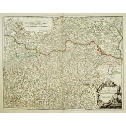
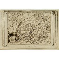
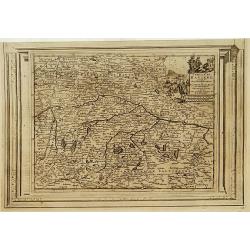
Partie Septentrionale du Cercle d'Autriche..
Detailed map of Austria, with an ornamental cartouche. Relief shown pictorially.
Date: Paris 1752.
Selling price: ????
Please login to see price!
Sold
Partie Septentrionale du Cercle d'Autriche...
Map showing the postal routes in The Netherlands, Belgium, France, Poland, Austria, Switzerland and Northern Italy. With an ornamental cartouche.
Date: Paris, 1752.
Selling price: ????
Please login to see price!
Sold
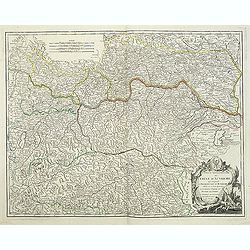
Partie Septentrionale du Cercle d'Autriche. . .
Detailed map of Austria, with an ornamental cartouche. Relief shown pictorially from his "Atlas Universel".Gilles Robert de Vaugondy (1688–1766), also known a...
Date: Paris 1752.
Selling price: ????
Please login to see price!
Sold
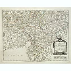
Partie Méridionale du Cercle d'Autriche. . .
Detailed map of Austria, with an ornamental cartouche. Relief shown pictorially from his "Atlas Universel".Gilles Robert de Vaugondy (1688–1766), also known a...
Date: Paris 1752.
Selling price: ????
Please login to see price!
Sold in 2019
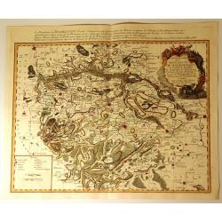
Carte Particuliere de la Principaute de Halberstadt
Carte Particuliere de la Principaute de Halberstadt. A large and rare map of Halberstadt, Germany, and its surroundings by Le Rouge. Showing the town in the German state...
Date: Paris, 17576
Selling price: ????
Please login to see price!
Sold in 2015