Browse Listings in Asia > Philippines
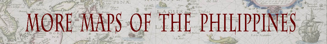
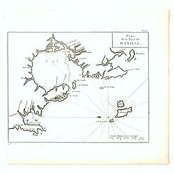
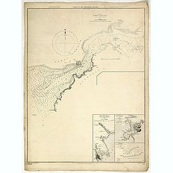
Plan de la baye et Ville de Manille, Capitale des Isles de Philippines . . .
French sea chart of the inlet and city of Manila with latitude and longitude scales, compass rose and system of rhumb lines, soundings near coast and in bay areas.Publish...
Place & Date: Paris, Brest, Demonville, 1775
Selling price: $1150
Sold in 2012
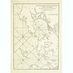
Plan du port de Subec, en l'Isle de Luçon.
French sea chart of Subic Bay and the town of "Subec", prepared in 1766. Subic is a 1st class municipality in the province of Zambales, Philippines. It is found...
Place & Date: Paris, Brest, Demonville, 1775
Selling price: $475
Sold in 2012
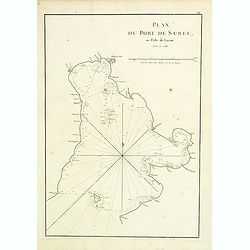
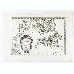
Carte de l'Archipel de St Lazare ou les Isles Marianes.
An interesting map the archipelago of St Lazare or Marianne's islands, on Alsonso P. Lopez maps and the Spanish Jesuits memory .Prepared by Jacques Nicolas Bellin after D...
Place & Date: Paris, 1738-1775
Selling price: $20
Sold in 2017
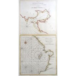
Plan of Solsogon Harbour / Chart on the Eastern Coast of Bongo Bay (Mindanao).
A nice copper engraving, with 2 Philippine sea charts on one sheet, published by Laurie & Whittle in London; pl. 125. With the usual sand banks, depth soundings, rhum...
Place & Date: London, 1794-1778
Selling price: $500
Sold in 2020
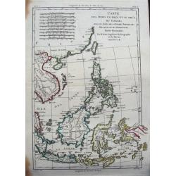
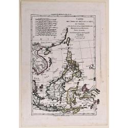
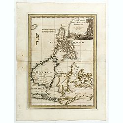
Carte des Indes en deçà et au delà du Gange...
Detailed 18th century map of the Philippines, Borneo, and parts of Indonesia from the Strait of Singapore to New Guinea. Includes also Formosa (Taiwan) and Hainan. A deta...
Place & Date: Paris, ca. 1780
Selling price: $80
Sold in 2015
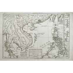
Les Isles Philippines, celle de Formose, le sud de la Chine,...
A very interesting map of the South China Sea and the Philippines. Highly detailed with numerous places and islands named.Extends from Pegu and Thailand to Taiwan, and so...
Place & Date: Paris, c1780
Selling price: $56
Sold in 2016
Plan de la Baye de Manille.
Detailed plan of Manila Bay engraved by Jean Lattré after Anson's key plan of the Bay of Manila. With a compass rose and soundings in the Bay.
Place & Date: Paris, c.1780
Selling price: $300
Sold in 2016
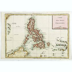
Carte des Isles Philippines.
Detailed map of Philippines, published by Louis Brion de la Tour. From the 'Histoire Universel'.More about maps of the Philippines. [+]
Place & Date: Paris, c.1780
Selling price: $300
Sold in 2019
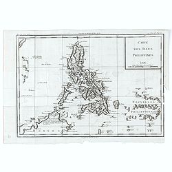
Carte des Isles Philippines.
Detailed map of Philippines, published by Louis Brion de la Tour. From the 'Histoire Universel'.More about maps of the Philippines. [+]
Place & Date: Paris, c.1780
Selling price: $310
Sold in 2020
![[2 maps] Carte de la partie Orientale des Philippines. / .. Occidentale ..](/uploads/cache/17587-250x250.jpg)
[2 maps] Carte de la partie Orientale des Philippines. / .. Occidentale ..
Two maps together forming a map of the Philippines, within upper left corner inset: Trombe Marine.Engraved by A.J. Gaitte and included in volume II of Le Gentil de la Gal...
Place & Date: Paris 1781
Selling price: $350
Sold
Carta dell' Isole Filippine . . .
Map of Philippines from the Italian edition of Abbè Presvost’s “Histoire Générale des Voyages”. The Histoire Géneral des Voyages was a monumental eighteenth cen...
Place & Date: Venice, ca. 1781
Selling price: $70
Sold in 2020
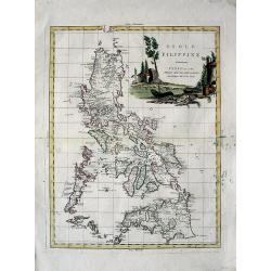
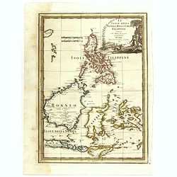
Isole Filippine
Important large map of the Philippines by Zatta published in his "Atlante Novissimo". Very detailed with even tiny islands shown and named. Decorative title car...
Place & Date: Venice, 1785
Selling price: $500
Sold in 2008
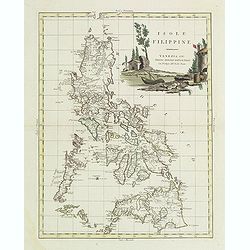
Isole Filippine.
One of the most decorative and sought after separate maps of the Philippines, based on the very rare map of Velarde. Covers all of the islands with remarkable detail. Dec...
Place & Date: Venise, 1785
Selling price: $500
Sold in 2011
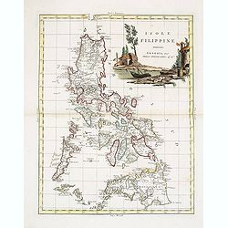
Isole Filippine.
One of the most decorative and sought after separate maps of the Philippines, based on the very rare map of Velarde. Covers all of the islands with remarkable detail. Dec...
Place & Date: Venise, 1785
Selling price: $600
Sold in 2013
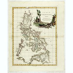
Isole Filippine.
One of the most decorative and sought after separate maps of the Philippines, based on the very rare map of Velarde. Covers all of the islands with remarkable detail. Dec...
Place & Date: Venise, 1785
Selling price: $1350
Sold in 2015
No title: Map of Philippines, Taiwan and China.
Interesting map centred on the Philippines. Showing the tracks of Byron, Wallis and Marshall.
Place & Date: Vienna 1790
Selling price: $420
Sold in 2017
Carte des Indes en deça et au delà du Gange. . .
A copper engraved map.
Place & Date: Venise, 1790
Selling price: $50
Sold in 2017
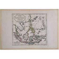
Les Isles de la Sonde, Moluques, Philippines, Carolines et Marianes Par Robert de Vaugondy.
From the atlas Nouvel Atlas Portatif destiné principalement à la jeunesse d'après la Géographie Moderne de l'Abbé Delacroix, published by Felix Delamarche, in Paris....
Place & Date: Paris, 1795
Selling price: $40
Sold in 2017
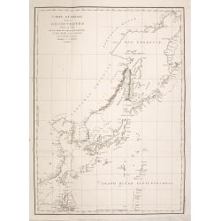
Carte Generale des Decouvertes Faites en 1787 dans les Mers de Chine et de Tartarie ou depuis Manille jusqu'a Avatsch. . .
La Pérouse's important depicting his track from the northern tip of the Philippines along China, Taiwan, Korea, Japan, Hokkaido, the Kuriles and the tip of Kamtschatka....
Place & Date: Paris, 1797
Selling price: $350
Sold in 2014
Le Isole della Sonda, Molluche, e Filippine delineate sulle ultima osservazioni.
First edition on laid paper. Cassini’s splendid early map of Philippines, Brunei, Celebes, Moluccas, Java and Timor, with large decorative title cartouche.This is one o...
Place & Date: Rome, 1797
Selling price: $1200
Sold in 2018
Le Isole della Sonda, Molluche, e Filippine delineate sulle ultima osservazioni.
First edition on laid paper. Cassini’s splendid early map of Philippines, Brunei, Celebes, Moluccas, Java and Timor, with large decorative title cartouche.This is one o...
Place & Date: Rome, 1797
Selling price: $1250
Sold in 2020
Nouvelle description des Iles Carolines. au R. P. Daubenton.
A very unusual map of the Caroline Islands with Palau. Includes a small part of Guiuan in the Philippines. Includes the tracks of Dr. Bern in 1712.
Place & Date: Unknown, ca. 1800
Selling price: $80
Sold in 2017
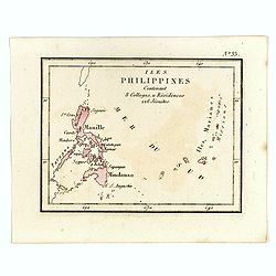
Isles Philippines Contenant 8 Colleges, u Résidences 226 Jésuites.
Rare map of Philippines from "Atlas Universel indiquant les établissemens des Jésuites: avec la manière dont ils divisent la terre, suivi desévénemens remarquab...
Place & Date: Paris, Ambroise Dupont , 1826
Selling price: $800
Sold in 2016
![[Port of Cavite on the Philippines].](/uploads/cache/25843-250x250.jpg)
[Port of Cavite on the Philippines].
Aquatint depicting a two row boats in the harbor of Cavite in the Bay of Manila. One person is a Chinese merchant. Signed G.G. Plate N° 52 From Giulio Ferrario's work Le...
Place & Date: Milan, 1827
Selling price: $70
Sold in 2008
![[ Philippine people in local dress ].](/uploads/cache/25844-250x250.jpg)
[ Philippine people in local dress ].
Aquatint depicting a group of Philippine women and a man conversing in the forest. Plate N° 53 From Giulio Ferrario's work Le Costume Ancien et Moderne ou Histoire du go...
Place & Date: Milan, 1827
Selling price: $65
Sold in 2008
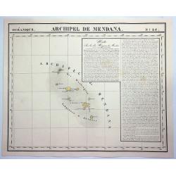
Archipel de Medana. No. 34.
A hand-colored, lithographed, large format map of the Archipel de Medana (Iles Washington) between Viet Nam and the Philippines. The map provides good topographic details...
Place & Date: Brusselles, 1827
Selling price: $11
Sold in 2020
Mapa general de las islas Philipinas Ano de 1849.
Provenance : Ex libris del Marqués de Pidal. Mapa Filipinas. 1847. N° 20. In lower left bottom a label : Junta delegada de incautacion proteccion y Salvamento del tesor...
Place & Date: Spain, c. 1849
Selling price: $13100
Sold in 2011
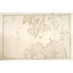
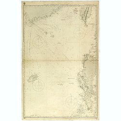
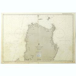
China sea - Philippine Islands. Eastern part of the Sulu..
Very detailed chart of the eastern part of the Sulu or Mindoro Sea. The main source are earlier Spanish charts, but with corrections by partial surveys of Sir Edward Belc...
Place & Date: London 1859
Selling price: $100
Sold
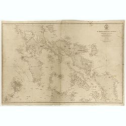
St Bernardino Strait and Parts Adjacent.
Philippines chart, with Manilla Bay in upper left corner. Published by the Hydrographic Office of the Admiralty in London. Sold by J. Potter, London, who was the agent fo...
Place & Date: London, 1859
Selling price: $1000
Sold in 2017
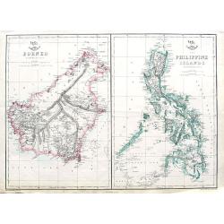
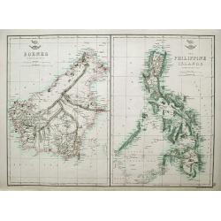
Borneo; The Philippine Islands;
Two maps on one sheet. Both maps are highly detailed, filled with place names.
Place & Date: London, ca. 1860
Selling price: $35
Sold in 2018
Borneo; The Philippine Islands.
Two maps on one sheet. Both maps are highly detailed, filled with place names. The Philippines are shown from the Bashee Islands in the north to the Sooloo Archipelago in...
Place & Date: London, ca 1860
Selling price: $78
Sold in 2018
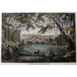
The Enchanted Lake in the Philippine Islands.
Original wood engraving drawn by Lancelot and engraved by Maurand. Beautiful scene of the lake with a deer and a crocodile. Attractive hand color.
Place & Date: London, c1870
Selling price: $20
Sold in 2016
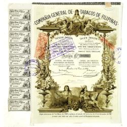
(Certificate) Accion ordinarias de 500 Pesetas.
Beautifully engraved certificate from the Compania General De Tabacos De Filipinas issued in 1882. This historic document has an ornate border with a vignette of allegori...
Place & Date: Barcelona, 1882
Selling price: $60
Sold in 2012
![East India archipelago [Western route to China, chart No. 6].](/uploads/cache/29948-250x250.jpg)
East India archipelago [Western route to China, chart No. 6].
Huge sailing chart showing the China Sea covering southeastern China in the vicinity of Hong Kong and Guangdong Province, southern Taiwan, and the northern Philippines (L...
Place & Date: London, 1888
Selling price: $1150
Sold in 2018
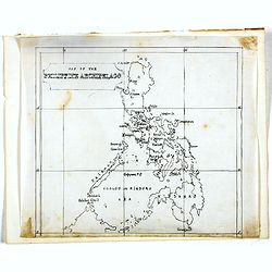
Manuscript map of the Philippine Archipelago.
An unusual small, and basic manuscript map of the Philippine Archipelago. Many small islands named.
Place & Date: London, ca. 1890
Selling price: $120
Sold in 2016
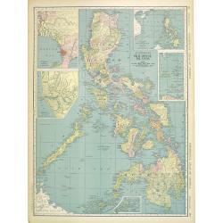
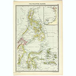
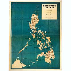
Philippine Islands.
Map of the Philippines, with insets of Manila, Manila vicinity, Sulu Archipelago, China Sea and Batan Islands. The shipping routes between the main cities are printed in ...
Place & Date: Chicago & New York, 1895
Selling price: $300
Sold in 2014
Philippine Islands.
Nice chromolithograph map of the Philippines, extending from the Bashee Channel and the southern tip of Formosa and Hong Kong to North Borneo and the Celebes Sea. Include...
Place & Date: Chicago, 1895
Selling price: $95
Sold in 2017
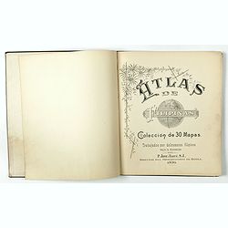
Atlas de Filipinas. Trabajados por delineantes filipinos. . .
First separately published atlas of the Philippine Islands. These detailed maps of the Philippine Islands were developed by Jesuits over many years and published by Treas...
Place & Date: Washington, 1900
Selling price: $220
Sold in 2018
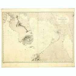
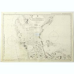
Philippines. Luzon Island/ Manila Bay / Surveyed by the Spanish Philippine Hyde. Commission under the direction of Captain Claudio Montero 1861.
Detailed chart of the Bay of Manilla based upon the Spanish Philippine Hydrographical surveys under the direction of Captain D. Claudio Montero in 1861. Some additional l...
Place & Date: London, 1861 / c.1900
Selling price: $850
Sold in 2019
Ports in the Philippine Island. Panay I. Port Ilo Ilo.
A fine Hydrographic Office chart no. 2391 (2649), corrected to Nov.r 1901 from a United States Government Suvey, 1900-1 and published during the Spanish American War.Show...
Place & Date: London, 1864 / Nov.r 1901
Selling price: $425
Sold in 2019
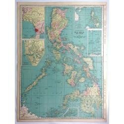
The Philippine Islands.
Map of Philippine Islands with inset map of Manila Habor.
Place & Date: London, ca. 1902
Selling price: $25
Sold in 2018
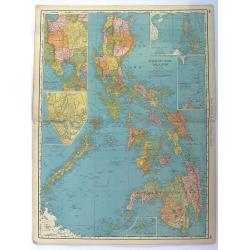
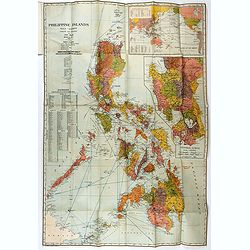
Philippine Islands.
Fine chromolithograph or colored lithograph map Of the Philippines, with insets of Manila, Manila to Dagupan, China Sea, Sulu Archipeligop and Batanes (Bashee). From �...
Place & Date: Chicago, 1903
Selling price: $50
Sold in 2016
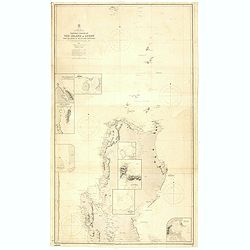
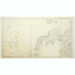
Northern Portion of The Island of Luzon with the Bashi & Balintang Channels The Island of Luzon by Lieutenant Claudio Montero Royal Spanish Navy 1859 The Batan Islands by Captain Sir. E. Belcher R.N. 1845.
Detailed chart on two joined sheets showing the northern portion of the Island of Luzon with the Bashi and Balintang Channels, drawn by Lieutenant Claudio Montero of the ...
Place & Date: London, 1867 / c. 1903
Selling price: $1300
Sold in 2019
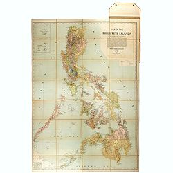
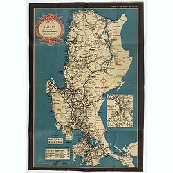
Hodgon's map of the Philippines Islands.
A very rare and important map of the Philippine Islands prepared by Caspar W. Hodgson and engraved by A. Briesemeister. The map measuring unfolded more than 1,4 x 1meters...
Place & Date: New York, World Book Company, 1908
Selling price: $4100
Sold in 2020
![Manila the perl of the Orient. Guide book to the intending visitor [with several photos and 3 plans of Manila]](/uploads/cache/48356-250x250.jpg)
Manila the perl of the Orient. Guide book to the intending visitor [with several photos and 3 plans of Manila]
Charming 1908 Guide book to with several photos and 3 folding plans of Manilla. Published by the "Manila merchants' association", directed by O'Connell, Daniel....
- $500 / ≈ €468
Place & Date: Manilla, 1908
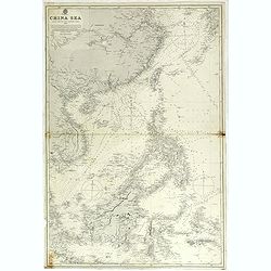
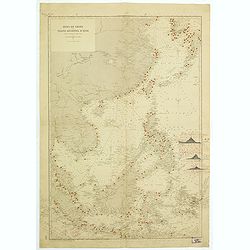
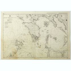
China sea compiled from the latest government surveys 1886.
Detailed sea chart of the "China Sea", first published by the British Admiralty in 1886, with correction to 1897 and small variations to 1913.Covering from 7° ...
Place & Date: London 1886 updated to 1897/1913
Selling price: $425
Sold in 2018
China Sea Northen portion - Eastern sheetCompiled from the latest Surveys 1881
Huge sailing chart showing the China Sea covering southeastern China in the vicinity of Hong Kong and Guangdong Province, southern Taiwan, and the northern Philippines (L...
Place & Date: London 1881 updated to 1897/1913
Selling price: $650
Sold in 2018
![Manila the perl of the Orient. The Philippines Land of Palm and Pine. Guide book to the intending visitor [with several photos and 3 plans of Manila]](/uploads/cache/48357-250x250.jpg)
Manila the perl of the Orient. The Philippines Land of Palm and Pine. Guide book to the intending visitor [with several photos and 3 plans of Manila]
Charming 1915 Guide book tothe Philippines with several photos. Published by the "Manila merchants' association". With charming cover illustrations by T.Gaudin...
Place & Date: Manilla, 1915
Selling price: $100
Sold in 2022
Philippine Islands
John Bach map of the Philippines published in Manila. Provinces are illustrated in different colors. Operating railroads on Luzon, Cebu, and Panay appear as thick black w...
Place & Date: Manilla, 1926
Selling price: $425
Sold in 2021
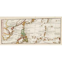
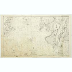
Mer de Chine et Grand Archipel d'Asie.
Large French sea chart featuring the Philippines, the coasts of China, Malaysia and Indonesia.On the back of the map, inscriptions in pencil indicate that the map figures...
Place & Date: France, 1897-1929
Selling price: $950
Sold in 2018
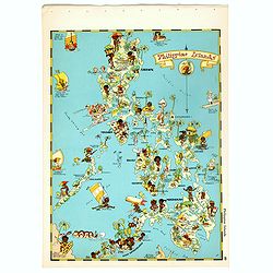
Philippines Islands.
Pictorial map of Philippines Islands, from the famous illustrator, Ruth Taylor White and published in "Our USA: A Gay Geography".Ruth Taylor White was among the...
Place & Date: Boston, Little, Brown and Company, 1935
Selling price: $175
Sold in 2017
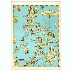
Philippines Islands.
Pictorial map of Philippines Islands, from the famous illustrator, Ruth Taylor White and published in "Our USA: A Gay Geography".Ruth Taylor White was among the...
Place & Date: Boston, Little, Brown and Company, 1935
Selling price: $250
Sold in 2018
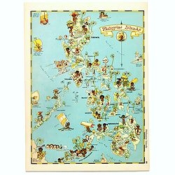
Philippines Islands.
Pictorial map of Philippines Islands, from the famous illustrator, Ruth Taylor White and published in "Our USA: A Gay Geography".Ruth Taylor White was among the...
Place & Date: Boston, Little, Brown and Company, 1935
Selling price: $175
Sold in 2017
![[No title : Map centered on Philippines]](/uploads/cache/39796-250x250.jpg)
[No title : Map centered on Philippines]
BONUS Map depicting a bird's-eye map centered on Philippines. Design by Ted Kautzky (1896-1953) (Enlargement of original map drawn for Life)."For report documenting ...
Place & Date: New York , Life Magazine, 1944
Selling price: $150
Sold in 2017
![[No title : War Map centered on Philippines]](/uploads/cache/40088-250x250.jpg)
[No title : War Map centered on Philippines]
BONUS Map depicting a bird's-eye map centered on Philippines. Design by Ted Kautzky (1896-1953) (Enlargement of original map drawn for Life)."For report documenting ...
Place & Date: New York , Life Magazine, 1944
Selling price: $160
Sold in 2018
Mapa de las yslas Philipinas Luzon . . .
Map of the Philippines. printed on a publication of YANK The army weekly, February 16, 1945. The map has an inset of Manila and vicinity, legend and a key to rail road a...
Place & Date: New York, 1945
Selling price: $255
Sold in 2017
![[ Pictorial map of the Philippine battlefield ]](/uploads/cache/43612-250x250.jpg)
[ Pictorial map of the Philippine battlefield ]
Pictorial map of central Luzon showing the Japanese Philippine battlefield by HR BIENNETT. Showing a road system, with the land and waters filled with war scenes. In uppe...
Place & Date: Philippines ?, 1945
Selling price: $375
Sold in 2019
Philippines Islands.
Wall map sized map of the Philippines on "water proof map no 3 Philippines" according note on lower right corner. No date or publisher. In right corner a key to...
Place & Date: USA, ca. 1945
Selling price: $425
Sold in 2020
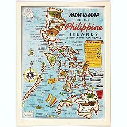
Mem-O-Map of the Philippine Islands.
Postwar map of the Philippines designed to help soldiers revisit their experiences.On board a ship returning home from the Pacific Theater, John Drury got together with o...
Place & Date: United-States, 1945
Selling price: $250
Sold in 2022
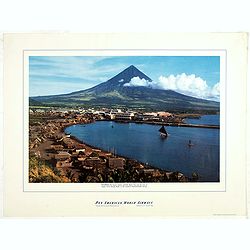
Philippines - The famous volcanic peak Mt. Mayon. . .
Mt Mayon Volcano Peak near Legaspi on the Philippines. Fine Pan American Airline mini poster.Pan American World Airways, originally founded as Pan American Airways and co...
Place & Date: 1956
Selling price: $150
Sold in 2023
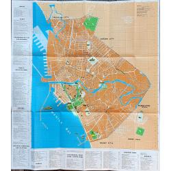
Manila and bay area
An unusual tourist leaflet with a large map of Manila, printed around 1960. Gives information about many locations, hotels, banks, government offices, clubs, churches, em...
Place & Date: Manila, ca. 1960
Selling price: $100
Sold in 2022
Philippine Islands - Luzon Island North of latitude 16°20' north from the United States and Philippine charts to 1980. . . (3805)
A highly corrected version of Admiralty chart 3805 originally published 1 December 1925 under the Superintendence of Captain H.P. Douglas. Edition Date 1991 with further ...
Place & Date: London, 1925 / 1999
Selling price: $100
Sold in 2018
Philippine Islands - Mindoro Strait and Sibuyan Sea. . . (3807)
A highly corrected version of Admiralty chart 3807 originally published 28 August 1923 under the Superintendence of Rear Admiral F.C. Learmonth. Edition Date29th April, 2...
Place & Date: London, 1923 / 2004
Selling price: $100
Sold in 2018
Philippine Islands - Tagolo Point to Cuyo Islands including Cebu, Negros andparts of Panay and Palawan. . . (3809)
A highly corrected version of this oversized Admiralty chart 3809 originally published 19th Augustus 1924 under the Superintendence of Vice Admiral F.C. Learmonth. Editio...
Place & Date: London, 1924 / 2005
Selling price: $130
Sold in 2018
Philippine Islands - Mindanao West Coast - Basilan Strait to Camiguin Island including Tubbataha Reefs. . . (3811)
A highly corrected version of this oversized Admiralty chart 3811 originally published 26th February 1925 under the Superintendence of Captain P.H. Douglas. Edition Date ...
Place & Date: London, 1925 / 2005
Selling price: $100
Sold in 2018
Philippine Islands - Luzon - west and east coast. Cabra I. to S.n Fernando P.t. Diapitan B. to S.n Miguel B. . . (3806)
Detailed chart of Luzon Island with Manila Bay, Cabra Island to S. Fernando Point Diapitan Bay to S. Miguel Bay.A highly corrected version of Admiralty chart 3806 origina...
Place & Date: London, 1922 / 2006
Selling price: $100
Sold in 2018