
Browse Listings in Asia > Philippines
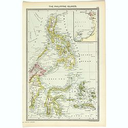
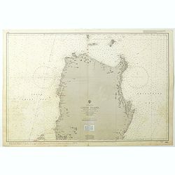
The Philippine Islands.
Map of Philippine Islands with inset map of Manila Habor.
Place & Date: London, ca. 1902
Selling price: $25
Sold in 2018
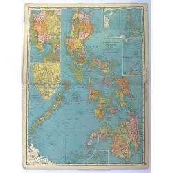
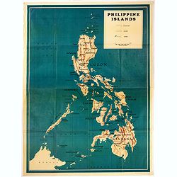
Philippine Islands.
Fine chromolithograph or colored lithograph map Of the Philippines, with insets of Manila, Manila to Dagupan, China Sea, Sulu Archipeligop and Batanes (Bashee). From �...
Place & Date: Chicago, 1903
Selling price: $50
Sold in 2016
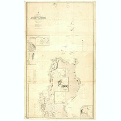
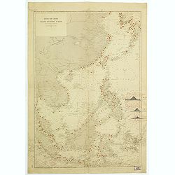
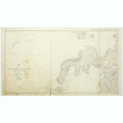
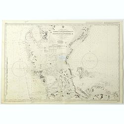
Northern Portion of The Island of Luzon with the Bashi & Balintang Channels The Island of Luzon by Lieutenant Claudio Montero Royal Spanish Navy 1859 The Batan Islands by Captain Sir. E. Belcher R.N. 1845.
Detailed chart on two joined sheets showing the northern portion of the Island of Luzon with the Bashi and Balintang Channels, drawn by Lieutenant Claudio Montero of the ...
Place & Date: London, 1867 / c. 1903
Selling price: $1300
Sold in 2019
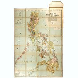
Hodgon's map of the Philippines Islands.
A very rare and important map of the Philippine Islands prepared by Caspar W. Hodgson and engraved by A. Briesemeister. The map measuring unfolded more than 1,4 x 1meters...
Place & Date: New York, World Book Company, 1908
Selling price: $4100
Sold in 2020
![Manila the perl of the Orient. Guide book to the intending visitor [with several photos and 3 plans of Manila]](/uploads/cache/48356-250x250.jpg)
Manila the perl of the Orient. Guide book to the intending visitor [with several photos and 3 plans of Manila]
Charming 1908 Guide book to with several photos and 3 folding plans of Manilla. Published by the "Manila merchants' association", directed by O'Connell, Daniel....
- $500 / ≈ €468
Place & Date: Manilla, 1908
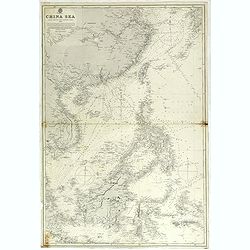
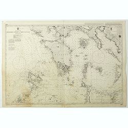
China sea compiled from the latest government surveys 1886.
Detailed sea chart of the "China Sea", first published by the British Admiralty in 1886, with correction to 1897 and small variations to 1913.Covering from 7° ...
Place & Date: London 1886 updated to 1897/1913
Selling price: $425
Sold in 2018
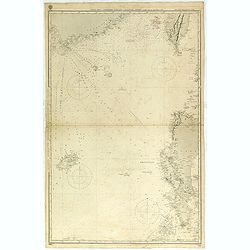
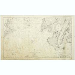
China Sea Northen portion - Eastern sheetCompiled from the latest Surveys 1881
Huge sailing chart showing the China Sea covering southeastern China in the vicinity of Hong Kong and Guangdong Province, southern Taiwan, and the northern Philippines (L...
Place & Date: London 1881 updated to 1897/1913
Selling price: $650
Sold in 2018
![Manila the perl of the Orient. The Philippines Land of Palm and Pine. Guide book to the intending visitor [with several photos and 3 plans of Manila]](/uploads/cache/48357-250x250.jpg)
Manila the perl of the Orient. The Philippines Land of Palm and Pine. Guide book to the intending visitor [with several photos and 3 plans of Manila]
Charming 1915 Guide book tothe Philippines with several photos. Published by the "Manila merchants' association". With charming cover illustrations by T.Gaudin...
Place & Date: Manilla, 1915
Selling price: $100
Sold in 2022
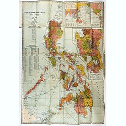
Philippine Islands
John Bach map of the Philippines published in Manila. Provinces are illustrated in different colors. Operating railroads on Luzon, Cebu, and Panay appear as thick black w...
Place & Date: Manilla, 1926
Selling price: $425
Sold in 2021
Mer de Chine et Grand Archipel d'Asie.
Large French sea chart featuring the Philippines, the coasts of China, Malaysia and Indonesia.On the back of the map, inscriptions in pencil indicate that the map figures...
Place & Date: France, 1897-1929
Selling price: $950
Sold in 2018
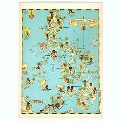
Philippines Islands.
Pictorial map of Philippines Islands, from the famous illustrator, Ruth Taylor White and published in "Our USA: A Gay Geography".Ruth Taylor White was among the...
Place & Date: Boston, Little, Brown and Company, 1935
Selling price: $175
Sold in 2017
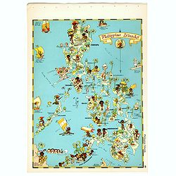
Philippines Islands.
Pictorial map of Philippines Islands, from the famous illustrator, Ruth Taylor White and published in "Our USA: A Gay Geography".Ruth Taylor White was among the...
Place & Date: Boston, Little, Brown and Company, 1935
Selling price: $250
Sold in 2018
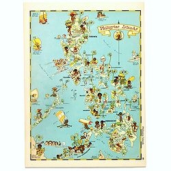
Philippines Islands.
Pictorial map of Philippines Islands, from the famous illustrator, Ruth Taylor White and published in "Our USA: A Gay Geography".Ruth Taylor White was among the...
Place & Date: Boston, Little, Brown and Company, 1935
Selling price: $175
Sold in 2017
![[No title : Map centered on Philippines]](/uploads/cache/39796-250x250.jpg)
[No title : Map centered on Philippines]
BONUS Map depicting a bird's-eye map centered on Philippines. Design by Ted Kautzky (1896-1953) (Enlargement of original map drawn for Life)."For report documenting ...
Place & Date: New York , Life Magazine, 1944
Selling price: $150
Sold in 2017
![[No title : War Map centered on Philippines]](/uploads/cache/40088-250x250.jpg)
[No title : War Map centered on Philippines]
BONUS Map depicting a bird's-eye map centered on Philippines. Design by Ted Kautzky (1896-1953) (Enlargement of original map drawn for Life)."For report documenting ...
Place & Date: New York , Life Magazine, 1944
Selling price: $160
Sold in 2018
Mapa de las yslas Philipinas Luzon . . .
Map of the Philippines. printed on a publication of YANK The army weekly, February 16, 1945. The map has an inset of Manila and vicinity, legend and a key to rail road a...
Place & Date: New York, 1945
Selling price: $255
Sold in 2017
![[ Pictorial map of the Philippine battlefield ]](/uploads/cache/43612-250x250.jpg)
[ Pictorial map of the Philippine battlefield ]
Pictorial map of central Luzon showing the Japanese Philippine battlefield by HR BIENNETT. Showing a road system, with the land and waters filled with war scenes. In uppe...
Place & Date: Philippines ?, 1945
Selling price: $375
Sold in 2019
Philippines Islands.
Wall map sized map of the Philippines on "water proof map no 3 Philippines" according note on lower right corner. No date or publisher. In right corner a key to...
Place & Date: USA, ca. 1945
Selling price: $425
Sold in 2020
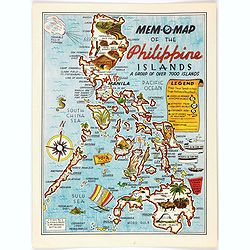
Mem-O-Map of the Philippine Islands.
Postwar map of the Philippines designed to help soldiers revisit their experiences.On board a ship returning home from the Pacific Theater, John Drury got together with o...
Place & Date: United-States, 1945
Selling price: $250
Sold in 2022
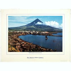
Philippines - The famous volcanic peak Mt. Mayon. . .
Mt Mayon Volcano Peak near Legaspi on the Philippines. Fine Pan American Airline mini poster.Pan American World Airways, originally founded as Pan American Airways and co...
Place & Date: 1956
Selling price: $150
Sold in 2023
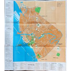
Manila and bay area
An unusual tourist leaflet with a large map of Manila, printed around 1960. Gives information about many locations, hotels, banks, government offices, clubs, churches, em...
Place & Date: Manila, ca. 1960
Selling price: $100
Sold in 2022
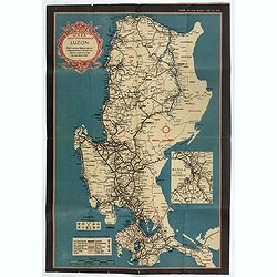
Philippine Islands - Luzon Island North of latitude 16°20' north from the United States and Philippine charts to 1980. . . (3805)
A highly corrected version of Admiralty chart 3805 originally published 1 December 1925 under the Superintendence of Captain H.P. Douglas. Edition Date 1991 with further ...
Place & Date: London, 1925 / 1999
Selling price: $100
Sold in 2018
Philippine Islands - Mindoro Strait and Sibuyan Sea. . . (3807)
A highly corrected version of Admiralty chart 3807 originally published 28 August 1923 under the Superintendence of Rear Admiral F.C. Learmonth. Edition Date29th April, 2...
Place & Date: London, 1923 / 2004
Selling price: $100
Sold in 2018
Philippine Islands - Tagolo Point to Cuyo Islands including Cebu, Negros andparts of Panay and Palawan. . . (3809)
A highly corrected version of this oversized Admiralty chart 3809 originally published 19th Augustus 1924 under the Superintendence of Vice Admiral F.C. Learmonth. Editio...
Place & Date: London, 1924 / 2005
Selling price: $130
Sold in 2018
Philippine Islands - Mindanao West Coast - Basilan Strait to Camiguin Island including Tubbataha Reefs. . . (3811)
A highly corrected version of this oversized Admiralty chart 3811 originally published 26th February 1925 under the Superintendence of Captain P.H. Douglas. Edition Date ...
Place & Date: London, 1925 / 2005
Selling price: $100
Sold in 2018
Philippine Islands - Luzon - west and east coast. Cabra I. to S.n Fernando P.t. Diapitan B. to S.n Miguel B. . . (3806)
Detailed chart of Luzon Island with Manila Bay, Cabra Island to S. Fernando Point Diapitan Bay to S. Miguel Bay.A highly corrected version of Admiralty chart 3806 origina...
Place & Date: London, 1922 / 2006
Selling price: $100
Sold in 2018