Browse Listings in Asia > Korea (and Japan)
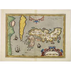
IAPONIAE INSULAE DESCRIPTIO. Ludoico Teisera auctore.
RARE in this perfect condition. The map was based upon the manuscript draft supplied to Ortelius in about 1592 by the famous official Portuguese chart maker, Luis Teixeir...
Place & Date: Antwerp, 1601
Selling price: $3500
Sold in 2017
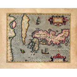
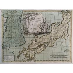
Japonia
One of the earliest views of Japan and Korea. This is a very attractive, boldly engraved map.The map is based on Abraham Ortelius' map which in turn was based on the ma...
Place & Date: Amsterdam, (1606) 1613
Selling price: $1150
Sold in 2011
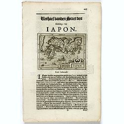
Iapan.
Small map of Japan, surrounded by text in Dutch. Nicolaes de Clerck (de Klerc) was active as engraver and publisher in Delft from 1599-1621.Included in the rare book : We...
Place & Date: Amsterdam, Cloppenburch, 1621
Selling price: $150
Sold in 2017
![IAPONIA, Petrus Kaerius Coelavit [Korea as an Island].](/uploads/cache/85228-250x250.jpg)
IAPONIA, Petrus Kaerius Coelavit [Korea as an Island].
An extremely rare variant of the map of Japan and Korea, based on Jodocus Hondius' folio map of Japan. The map follows the Ortelius/Teixeira type for Japan, with Korea sh...
Place & Date: Amsterdam,1676
Selling price: $600
Sold in 2021
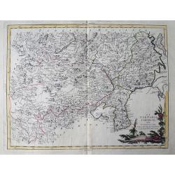
![[Lot of 3 maps] Tabula Tartariae et Regni China.](/uploads/cache/100353-(2)-250x250.jpg)
[Lot of 3 maps] Tabula Tartariae et Regni China.
Frederick de Wit (1610-1698) became after the closing of the Blaeu firm one of the most important Amsterdam-based publishers. He published several atlases, Atlas Minor (1...
Place & Date: c. 1680
Selling price: $235
Sold in 2022
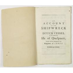
An account of the shipwreck of a Dutch vessel on the coast of the Isle of Quelpaert, together with the description of the kingdom of Corea. Translated out of French.
FIRST ENGLISH EDITION. A 26 page description extracted from the first edition of Churchill's "A Collection of Voyages and Travels: Some Now First Printed from Origin...
Place & Date: London, 1704
Selling price: $2600
Sold in 2011
Description geographique, historique, chronologique, politique, et physique de l'empire de la Chine et de la Tartarie chinoise.
First edition of this cornerstone of any collection of books on China, which is also among the rarest and most desirable of important Americana, included in Rare American...
Place & Date: Paris, P. G. Le Mercier, 1735
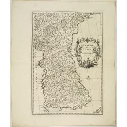
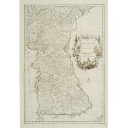
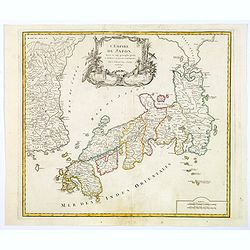
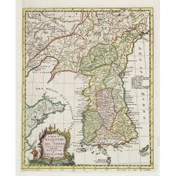
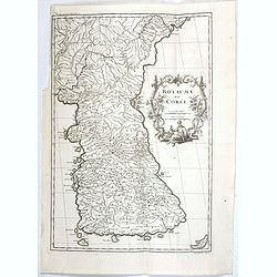
Royaume de Corée.
With a quite elaborately pictorial cartouche, engraved by G.Kondet. One of the earliest separate maps of Korea. Jean Baptiste Bourguignon d' Anville (1697-1782), French c...
Place & Date: The Hague, 1737
Selling price: $4000
Sold in 2010
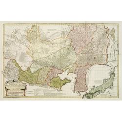
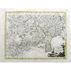
Carte Generale De La Tartarie Chinoise Dressee sur les Cartes Particulieres Faits Sur Les Lieux Par Les R.R. P.P. Jesuites . . . .MDCCXXXII
D'Anville is very important for Korean cartography as he made the cartography of Korea widely available. The map is the first fairly accurate western map of Korea, though...
Place & Date: The Hague, 1732-1737
Selling price: $1800
Sold
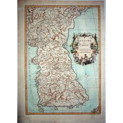
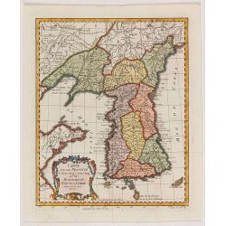
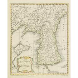
ROYAUME DE COREE.
The first separate map of Korea by a European cartographer. A fine engraved map of Korea, the title within a fine rococo historiated cartouche middle right, decorated wit...
Place & Date: Paris, 1737
Selling price: $3000
Sold in 2021
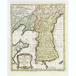
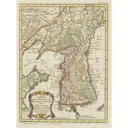
Royaume de Corée.
With a quite elaborately pictorial cartouche, engraved by G.Kondet. One of the earliest separate maps of Korea. Jean Baptiste Bourguignon d' Anville (1697-1782), French c...
Place & Date: The Hague, 1737
Selling price: $1350
Sold
Carte du Japon et de la Korea.
Le Rouge's map of Japan follows the type established by D'Anville with the disproportionately large Korean Peninsula.The large title cartouche features three Japanese god...
Place & Date: Paris, 1748
Selling price: $160
Sold in 2017

Le Japon.
The map is of interest for the use of Mer de Corée, for the sea between Korea and Japan. Small detailed map of Japan and Korea. Dated 1749. A note next to island &quo...
Place & Date: Paris, 1749
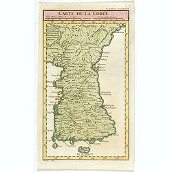
Carte de la Corée.
A rare map of Korea after d'Anville and engraved by Dheulan.
Place & Date: Paris, ca. 1750
Selling price: $350
Sold in 2021
Carte du Katay ou Empire de Kin. . .
Fine map of Korea and China's Yellow Sea. Complete title in top: Carte du Katay ou Empire de Kin, pour servir de l'Histoire de Jenghiz Khan. Raportée dans histoire Gén�...
Place & Date: Paris, 1750
Selling price: $420
Sold
Carte du Katay ou Empire de Kin, Pour servir a l'histoire de Jenghiz Khan. raportée dans l'histoire generale des voyages. Tirée de l'Anglois.
Fine map of Korea and China's Yellow Sea. Complete title in top: Carte du Katay ou Empire de Kin, pour servir de l'Histoire de Jenghiz Khan. Raportée dans histoire Gén�...
Place & Date: Paris, 1750
Selling price: $375
Sold in 2011
Carte du Katay ou Empire de Kin..
Fine map of Korea and China's Yellow Sea. Complete title in top: Carte du Katay ou Empitre de Kin, pour servir de l'Histoire de Jenghiz Khan. Raportée dans histoire Gene...
Place & Date: Paris 1750
Selling price: $200
Sold
Carte du Katay ou Empire de Kin. . .
The map is of interest for the use of Mer de Corée, for the sea between Korea and Japan .Fine map of Korea and China's Yellow Sea. Complete title in top: Carte du Katay ...
Place & Date: Paris, 1750
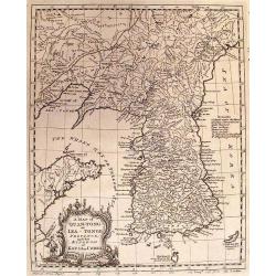
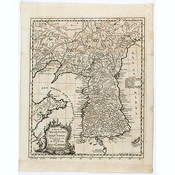
A MAP OF QUAN-TONG OR LEA-TONGE PROVINCE and the KINGDOM OF KAU-LI OR COREA.
Detailed map of Korea, Liaodong, and the tip of Shandong Province prepared by Thomas Kitchin for Thomas Salmon's Universal Traveller, based on D'Anville's landmark map of...
Place & Date: LONDON, 1753
Selling price: $350
Sold in 2010
L'Empire du Japon. . .
Very similar to Joan Blaeu's map of 100 years previously: Europeans by then had been expelled, except the Dutch, whose movements were so curtailed that they were not able...
Place & Date: Paris, 1756
Selling price: $195
Sold in 2019
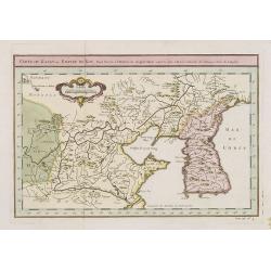
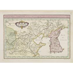
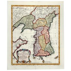
Carte de la province de Quan-tong, ou Lyau-tong et du Royaume de Kau-li. . .
Map of Korea. The map is of interest for the use of East Sea, the sea between Korea and Japan, here called "Mer de Corée".Decorative title cartouche in lower l...
Place & Date: Paris, 1757
Selling price: $350
Sold in 2021
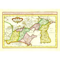
Carte de la province de Quan-tong, ou Lyau-tong et du Royaume de Kau-li. . .
Map of Korea. The map is of interest for the use of East Sea, the sea between Korea and Japan, here called "Mer de Corée.Decorative title cartouche in lower left co...
Place & Date: Paris, 1757
Selling price: $750
Sold in 2013
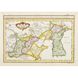
Carte de la Province de Quantong ou Lyau tong et du Royaume de KAU-LI ou COREE
Uncommon issue of this fine map of Korea. The map is of interest for the use of East Sea, the sea between Korea and Japan, here called "Mer de Corée.Decorative titl...
Place & Date: Paris, 1749-1773
Selling price: $270
Sold in 2019
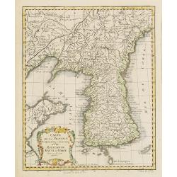
CARTE DE LA PROVINCE de Quan-tong ou Lyau-tong et du ROYAUME DE KAU-LI ou COREE (Korea).
An uncommon issue of this fine map of Korea. The map is of interest for the use of East Sea, the sea between Korea and Japan, here called "Mer de Corée". With ...
Place & Date: Paris, 1749-1773
Selling price: $270
Sold in 2019
A map of Quang-Tong or Lea-Tonge Province..
Detailed and decorative map of Korea in lower left corner a charming title cartouche. To the right "Sea of Korea".
Place & Date: London, 1777
Selling price: $120
Sold in 2020
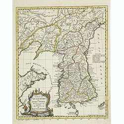
Carte de la Province de Quantong ou Lyau-tong et du Royaume de Kau-Li ou Corée . . .
Map of Korea. The map is of interest for the use of East Sea, the sea between Korea and Japan, here called "Mer de Corée Meer von Korea." Decorative title car...
Place & Date: Paris, 1780
Selling price: $700
Sold
A map of Quan-Tong or Lea-Tonge province, and the kingdom of Kau-Li or Corea . . .
Detailed map of Korea, Liaodong, and the tip of Shandong Province prepared by Thomas Kitchin for Thomas Salmon's Universal Traveller, based on D'Anville's landmark map of...
Place & Date: London, 1780
Selling price: $600
Sold
A map of Quan-Tong or Lea-Tonge province, and the kingdom of Kau-Li or Corea . . .
Detailed map of Korea, Liaodong, and the tip of Shandong Province prepared by Thomas Kitchin for Thomas Salmon's Universal Traveler, based on D'Anville's landmark map of ...
Place & Date: London, 1780
Selling price: $600
Sold
Carte de la Province de Quantong ou Lyau-tong et du Royaume de Kau-Li ou Corée . . .
Map of Korea. The language on the map is Dutch and French. The notation at the bottom indicates that the prime meridian is set at Ferro Island, otherwise known as El Hier...
Place & Date: Paris, 1780
Selling price: $475
Sold in 2010
Carte de la Province de Quantong ou Lyau-tong et du Royaume de Kau-Li ou Cor�e . . .
Map of Korea. The language on the map is Dutch and French. The notation at the bottom indicates that the prime meridian is set at Ferro Island, otherwise known as El Hier...
Place & Date: Paris, 1780
Selling price: $480
Sold
LA TARTARIA CHINESE.
An attractive copper engraved map of the Far East covering parts of China, South Korea, Mongolia, Russia and Japan (Jeso-Gasima). Includes the Chinese Wall, the Gobi dese...
Place & Date: Venice, 1784
Selling price: $165
Sold in 2019
LA TARTARIA CHINESE
Attractive copper engraved map of the Far East covering parts of China, Korea, Mongolia, Russia and Japan (Jeso-Gasima). Includes the Chinese Wall, the Gobi desert, Lake ...
Place & Date: Venice, 1784
Selling price: $105
Sold in 2011
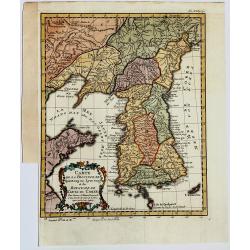
Royaume de Corée.
One of the earliest separate maps of Korea. The map engraved by the master engraver Delahaye, with a quite elaborately pictorial cartouche, engraved by G.Kondet. Jean Bap...
Place & Date: Paris, Ph.-D. Pierres, Clousier [- Moutard], 1785
Selling price: $2600
Sold in 2017
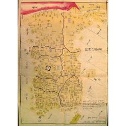
Chosen hachido no zu (or) Chosen koku zenzu (General map of korea)
Bold, beautifully colored road-map of Korea by the great Hayashi Shihei. Banned by the Edo government in 1792. A banned map !In 1785 Hayashi Shihei made the Sangoku Ts&am...
Place & Date: Edo, Suharaya Shihei, in Temmei 5 or 1786
Selling price: $3500
Sold
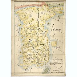
Chosen hachido no zu (or) Chosen koku zenzu (General map of korea)
Bold, beautifully colored road-map of Korea by the great Hayashi Shihei. Banned by the Edo government in 1792. A banned map !In 1785 Hayashi Shihei made the Sangoku Tsura...
Place & Date: Edo, Suharaya Shihei, in Temmei 5 or 1786
Selling price: $2000
Sold in 2017
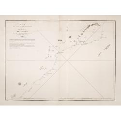
Plan de la partie des iles, ou archipel de Coree, vue au mois de Mai 1787 par les Fregates Francaises la Boussole et l'Astrolabe. . . .
Showing the track of La Perouse along the southern most tip of Korea, with Quelpaerts Islands (now-a-days called Jeju, with the vulcano Halla-san (Halla Mountain) clearly...
Place & Date: L'Imprimerie de la Republique, An V, 1797
Selling price: $500
Sold in 2014
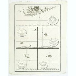
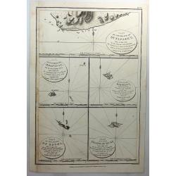
Plan de la partie de l'ile de quelpaert. . . / Plan de l'ile Hoapinsu. . . / Plan de l'ile Dagelet. . . / Plan de la partie de l'ile de Botol. . . / Plan de l'ile de Kumi. . .
Five plans on a folio sheet. These charts include Cheju Do, Korea (Quelpaert Is.), Kume-Shiwa, Okinawa (Kumi), and Ullung Do (Dagelet).Including one of the earliest maps ...
Place & Date: Paris, 1797
Selling price: $350
Sold in 2011
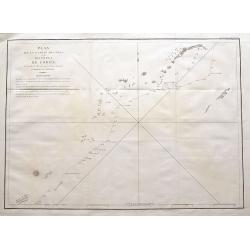
Plan de la partie des Îles, ou Archipel de Corée, Vue au Mois de Mai 1787 par les Frégates Francaises la Boussole et l'Astrolabe.
La Pérouse's important and detailed sea-chart showing the route of his ships the Boussoule & Astrolabe between the South Korean island of Jeju (here called Ile Quelp...
Place & Date: Paris, 1797
Selling price: $55
Sold in 2016
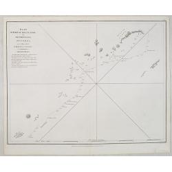
Plan of part of the Islands or Archipelago of Corea.
Showing the track of La Perouse along the southern most tip of Korea, with Quelpaerts Islands (now-a-days called Jeju, with the vulcano Halla-san (Halla Mountain) clearly...
Place & Date: London, G.G. and J.Robinson, 1798
Selling price: $360
Sold
Part of the Island of Quelpaert, Hoapinsu, Dagelet, Botol & Kumi.
A fine copper engraved chart with inserts of the Islands of Quelpaert, Hoapinsu, Dagelet, Botol & Kumi. From Ls Perouse’s ATLAS DU VOYAGE DE LA PEROUSE. Published ...
Place & Date: London, 1798
Selling price: $32
Sold in 2018