Browse Listings in Asia > India > Sri Lanka (Ceylon)
![Taprobana Ins. Tabula XII Asiae. [Sri Lanka.]](/uploads/cache/35395-250x250.jpg)
Taprobana Ins. Tabula XII Asiae. [Sri Lanka.]
Ptolemy's mythical island of Taprobana originally became associated with Sri Lanka although it was sometimes confused with Sumatra. Taprobana, as it was called on most ea...
Place & Date: Lyons, M. Servetus, 1535
Selling price: $400
Sold in 2016
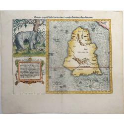
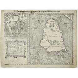
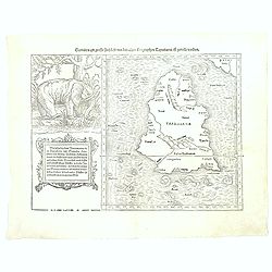
Sumatra ein grosse Insel, so von den alten Geographen Taprobana, ist genent worden (Sri Lanka).
One of the earliest and highly decorative woodcut maps of Ceylon (Sri Lanka) by Sebastian Münster. To the left of the map a cartouche with explanatory text in 10 lines a...
Place & Date: Basel, ca 1540
Selling price: $225
Sold in 2019
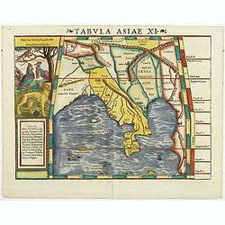
Tabula Asiae XI.
Attractive early woodblock map of South East Asia, with inset panel of tiger, cockerels and parrot. Woodcut map with full hand-coloring as known to Ptolemy. From his Geog...
Place & Date: Basle, H. Petri, c. 1542
Selling price: $650
Sold in 2011
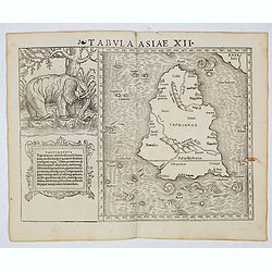
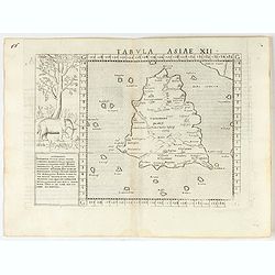
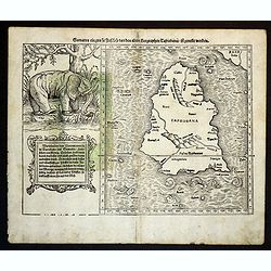
Tabula Asiae XII (Sri Lanka, with Elephant)
The FIRST edition of Munster's first modern map of Sri Lanka, which appeared in his "Geographia Universalis", first published in 1540. The Geographia was a new ...
Place & Date: Basel, Heinrich Petri, 1545
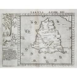
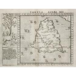
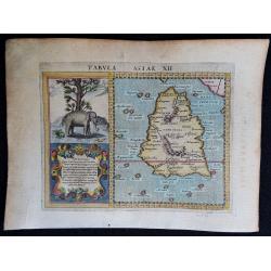
Tabvla Asiae XII.
[Antique map of Sri Lanka] Tabvla Asiae XII. An elegantly engraved early map of Sri Lanka, (misshapen) with left the image of an elephant.
Place & Date: Venice, 1561
Selling price: $130
Sold in 2020
Tabula Asiae XII. (Taprobana)
Scarce FIRST edition of this map depicting the island of Ceylon (Taprobana), based on Gastaldi's 1548 map. An elephant with descriptive text next to the map.Ptolemy's myt...
Place & Date: Venice, 1561
Selling price: $160
Sold in 2023
Tabvla Asiae XII.
An elegantly engraved early map of Sri Lanka, with left the image of an elephant. Ref.: Paranavitana, maps of Dutch Ceylon, p.7.
Place & Date: Venice, 1561
Selling price: $400
Sold
![Taprobana [Ceylon/Sri Lanka].](/uploads/cache/84457-250x250.jpg)
Taprobana [Ceylon/Sri Lanka].
Ptolemy's mythical island of Taprobana originally became associated with Sri Lanka. Later, as this theory was discredited, Sumatra became the next candidate. Almost a dec...
Place & Date: Basle, 1561
Selling price: $150
Sold in 2020
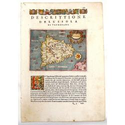
Descrittione del l'Isola di Taprobana.
Charming map of the island of Sri Lanka (Celon). The map is oriented with north to the right. Fancy strapwork cartouche with two faces and a unique compass rose. Printed ...
Place & Date: Venice, 1572
Selling price: $99
Sold in 2013
Sumatra ein grosse Insel, so von den alten Geographen Taprobana, ist genent worden (Sri Lanka).
A nice impression of this great map of island of Tabrobana, which was variously thought to be Ceylon or Sumatra. This map depicts Ceylon with the typical misconceptions o...
Place & Date: Basle, 1574
Selling price: $250
Sold in 2021
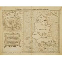
Sumatra Ein Grosse Insel / So Von Den alten Geographen Taprobana...
A fine map of what is regarded as the island of Sri Lanka, by the early, important, and influential German cartographer, Sebastian Munster. The map title, in old German s...
Place & Date: Basle ca. 1550 - 1580
Selling price: $170
Sold in 2016
![Tabula Asiae XII [Sri Lanka -- with Elephant]](/uploads/cache/00684-250x250.jpg)
Tabula Asiae XII [Sri Lanka -- with Elephant]
Attractive woodblock map, depicting Sri Lanka as known to Ptolemy. Left of the map a large elephant with descriptive text identifies the island of Taprobana with Sumatra ...
Place & Date: Basle, 1580
Selling price: $300
Sold in 2017
Sumatra Ein Grosse Insel / So Von Den alten Geographen Taprobana...
A fine map of what is regarded as the island of Sri Lanka, by the early, important, and influential German cartographer, Sebastian Münster. The map title, in old German ...
Place & Date: Basle ca. 1550 - 1580
Selling price: $350
Sold in 2018
Sumatra ein grosse Insel..
A nice impression of this great map of island of Tabrobana, which was variously thought to be Ceylon or Sumatra.This map depicts Ceylon with the typical misconceptions of...
Place & Date: Basle 1580
Selling price: $200
Sold
![Taprobana. [Sri Lanka]](/uploads/cache/39986-250x250.jpg)
Taprobana. [Sri Lanka]
An attractive map of the island of Ceylon, or Sri Lanka, with north orientated to the right.Third edition from Porcacchi's L'isole piu famose.It features a pretty strap-w...
Place & Date: Venice, 1590
Selling price: $95
Sold in 2017
![Taprobana. [Sri Lanka]](/uploads/cache/47369-250x250.jpg)
Taprobana. [Sri Lanka]
An attractive map of the island of Ceylon, or Sri Lanka, with north orientated to the right. Third edition from Porcacchi's L'isole piu famose.It features a pretty strap-...
Place & Date: Venice, 1590
Selling price: $95
Sold in 2021
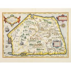
Tabula Asiae XII.
A very decorative copperplate map of Ceylon / Sri Lanka with a very elaborate cartouche and a charming engraving of an elephant.From the 1597 edition of Magini's "Ge...
Place & Date: Venice, 1597
Selling price: $140
Sold in 2018
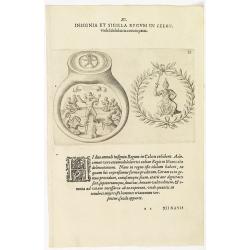
XI. Insignia et Sigilla Regum in Celon.
Theodore de Bry, a German engraver and book dealer, began a compilation of early voyages in 1590 and had published six parts at the time of his death in 1598. His widow, ...
Place & Date: Frankfurt, 1599
Selling price: $25
Sold in 2018
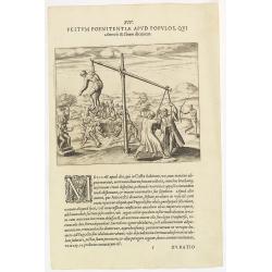
XIV. Festum Poenitentiae Apud Populos, Qui. . . ( Strange ceremonies in the state of Silon.)
Strange ceremonies in the state of Silon. Among the Oriental Indians are several from Casta who, whenever a man dies, digs a large pit. Then the corpse is placed in the o...
Place & Date: Frankfurt, 1599
Selling price: $50
Sold in 2018
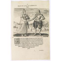
Regis in candt et Admiralis effigies. (The king of Candy meets the Dutch Admiral)
This shows the mighty king who received the name: Fimala Derura Suriada as a child in Colombo. He was also christened Don Lean d'Austria do Colombo. He is of royal blood ...
Place & Date: Frankfurt, 1599
Selling price: $100
Sold in 2016
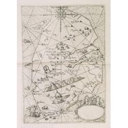
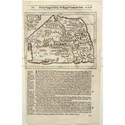
Maldivae Insulae.
A miniature map of The Maldives islands, situated southwest of Ceylon situated in the Arabian Sea, located in the Indian Ocean. North is orientated to the left. The south...
Place & Date: Amsterdam, 1606
Selling price: $50
Sold in 2019
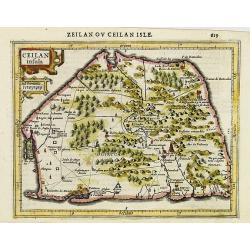
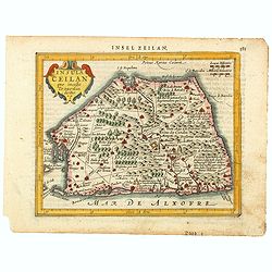
Ceilan insula.
Charming small map of the island of Sri Lanka with great detail of the villages, kingdoms, mines and spice plantations.Decorated with a strap work title and distance scal...
Place & Date: Amsterdam, 1608
Selling price: $200
Sold in 2017
IX. Tabula Cosmographica, Regionis Sive.
Early map of Ceylon (Sri-Lanka). Theodore de Bry, a German engraver and book dealer, began a compilation of early voyages in 1590 and had published six parts at the time ...
Place & Date: Frankfurt, 1609
Selling price: $850
Sold in 2010
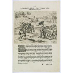
Delineatio Regis in Matecalo Hollandos. (Arrival of Sebald de Weert in Matecalo/Batticaloa).
Arrival of Sebald de Weert in Matecalo/Batticaloa, Ceylon (Sri Lanka).Theodore de Bry, a German engraver and book dealer, began a compilation of early voyages in 1590 and...
Place & Date: Frankfurt, 1609
Selling price: $90
Sold in 2016
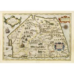
Ins. Ceilan que incolis Tenarisin dictur.
In 1606 J. Hondius introduced in the Mercator Atlas a separate map of Ceylon. Prepared by Petrus Plancius who was at the time the official map maker of the V.O.C.Early ma...
Place & Date: Amsterdam, 1609
Selling price: $900
Sold in 2016
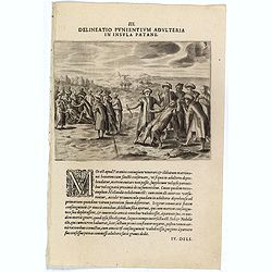
III. Delineatio Punientium Adulteria in Insula Patane. (Death of Sebald de Weerdt.)
Showing the death of Sebald de Weert (1567 – 1603) was a Dutch captain and vice-admiral of the Dutch East India Company (VOC). He is most widely remembered for accurate...
Place & Date: Frankfurt, 1609
Selling price: $120
Sold
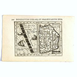
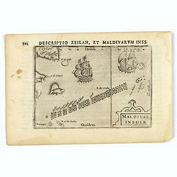
Descriptio Zeilan, Maldivarum Inss.
FIRST IMPRINT FROM THE NEWLY ENGRAVED PLATES IN 1616. - A rare miniature map of Ceylon/ Sri Lanka and Maladies. First published in 1598 in his Caert-Thresoor, the plates ...
Place & Date: Amsterdam, J. Hondius, 1616
Selling price: $200
Sold in 2020
Ceilan Insula.
The rare Samuel Purchas' edition of the Mercator/Hondius Atlas Minor atlas map. Early map of Sri Lanka published in his famous collection of voyages His Pilgrimes . With ...
Place & Date: London, 1625
Selling price: $120
Sold in 2020
Ceilan Insula.
The rare Samuel Purchas' edition of the Mercator/Hondius Atlas Minor atlas map. Early map of Ceylon published in his famous collection of voyages His Pilgrimes. With desc...
Place & Date: London 1625
Selling price: $130
Sold in 2013
Ins. Ceilan que incolis Tenarisin dictur.
In 1606 J. Hondius introduced in the Mercator Atlas a separate map of Ceylon. Prepared by Petrus Plancius.
Place & Date: Amsterdam, 1630
Selling price: $900
Sold
![[ Lot of 12 maps / views off India / Sri Lanka] Malabar.](/uploads/cache/20949-250x250.jpg)
[ Lot of 12 maps / views off India / Sri Lanka] Malabar.
Attractive little map of the southern part of the Indian subcontinent, focusing on the Malabar coast from Goa to Cape Comorin and its important trading posts. Also depict...
Place & Date: Amsterdam, c. 1630
Selling price: $180
Sold in 2023
Insula Ceilan que Incolis Tenarisin dictur.
An oddly shaped map of the island of Ceylon (Sri Lanka), engraved by Petrus Kaerius with plenty of good detail. Major settlements highlighted in red. In 1607 Jodocus Hon...
Place & Date: Amsterdam, 1631
Selling price: $95
Sold in 2020
Ins. Ceilan que incolis Tenarisin dictur.
In 1606 J. Hondius introduced in the Mercator Atlas a separate map of Ceylon. Prepared by Petrus Plancius
Place & Date: Amsterdam 1633
Selling price: $550
Sold
Ins. Ceilan que incolis Tenarisin dictur.
In 1606 J. Hondius introduced in the Mercator Atlas a separate map of Ceylon. Prepared by Petrus Plancius
Place & Date: Amsterdam 1633
Selling price: $550
Sold
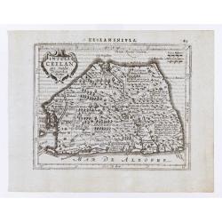
Insula Ceilan quae incolis Tenarisin dicitur.
Single page map of Sri Lanka. Latin text on verso.
Place & Date: Amsterdam, J.Janssonius, 1628-1634
Selling price: $96
Sold in 2020
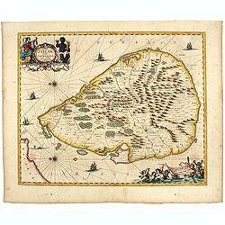
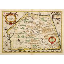
Insula Zeilan olim Taprobana nunc incolis tenarisim.
Janssonius' map of Sri Lanka. Including many VOC settlements and forts, several major town marked with a crown. Very decorative item with two large title and scale cartou...
Place & Date: Amsterdam, 1640
Selling price: $600
Sold in 2020
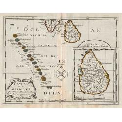
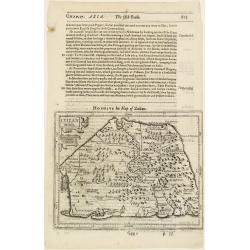
Ceylan, et les Maldives.
Map of the Maldive Islands, with an inset picturing Sri Lanka, from the first edition of the atlas L'Asie en plusieurs cartes nouvelles, et exactes & en divers traitt...
Place & Date: Paris, 1652
Selling price: $120
Sold in 2012
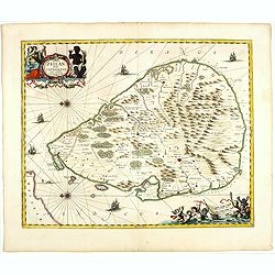
Insula Zeilan olim Taprobana nunc incolis tenarisim.
Janssonius' map of Sri Lanka. Including many VOC settlements and forts, several major town marked with a crown. Very decorative item, with two large title and scale carto...
Place & Date: Amsterdam, 1660
Selling price: $600
Sold in 2019
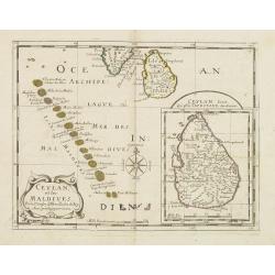
Ceylan et les Maldives. . .
A fine map of Shri Lanka, and the Maldives prepared by N.Sanson and published by Pierre Mariette.Published in an early edition of the small Sanson atlas L'Europe Dediée ...
Place & Date: Paris, P. Mariette, 1667
Selling price: $275
Sold in 2008
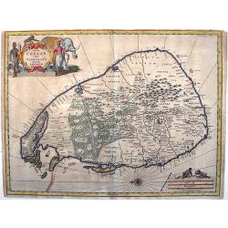
Insula Ceylan olim Taprobana nunc incolis Lankawn.
This rare map by Baldeus is show the island of Ceylon, oriented with east at the top. Two decorative cartousche embellish the map, which -a rarity for the time - shows de...
Place & Date: Amsterdam, ca 1670
Selling price: $140
Sold in 2017