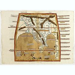
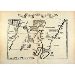
Undecima Asie Tabula.
Incunable wood block printed large-format Ptolemaic map showing Asia east of the Ganges with metal-type lettering within a colored trapezoid border, with a Latin-text on ...
Place & Date: Ulm, 1482-1486
Selling price: $6000
Sold in 2015
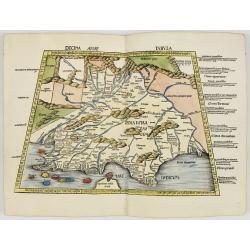
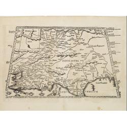
Decima Asie Tabvla.
Wood block map of India and part of Sri Lanka from Martin Waldseemüller's 1513 edition of Ptolemy, who was a landmark work that contributed to major advances in both Ren...
Place & Date: Strasbourg, J. Schott, 1513
Selling price: $9100
Sold
Tabula X. Asiae hae sunt e cognitis totius orbis.
The earliest printed representation of India west of the Ganges River in Ptolemy's time. Considerable detail of river systems and mountain ranges.The first issue of this...
- $1000 / ≈ €936
Place & Date: Lyons, M. Servetus, 1525
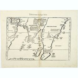
Tabula IX Asia (title on verso).
Martin Waldseemüller (1470-1521) drew the maps for the 1513 and 1520 editions of Ptolemy's ' Geographia'. They were revised and reduced by Laurent Fries and used for the...
Place & Date: Lyon, 1535
Selling price: $375
Sold
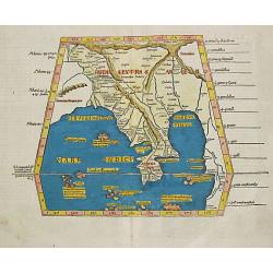
Tabu. moder. Indiae
Woodcut map of India by L. Fries. From the 1535 Lyon edition of Ptolemy's Geographia edited by M. Servetus and published by M. and G. Trechsel, printed from the 1522 wood...
Place & Date: Lyon, 1535
Selling price: $1400
Sold in 2010
Tabula X. Asiae hae sunt e cognitis totius orbis.
The earliest printed representation of India west of the Ganges River in Ptolemy's time. Considerable detail of river systems and mountain ranges.The first issue of this ...
Place & Date: Vienne 1541
Selling price: $550
Sold
Tabula IX Asia (title on verso).
Martin Waldseemüller (1470-1521) drew the maps for the 1513 and 1520 editions of Ptolemy's ' Geographia'. They were revised and reduced by Laurent Fries and used for the...
Place & Date: c. 1541
Selling price: $450
Sold in 2008
Tabula nova utriusque Indiae
This is the fourth and last edition of this map based on Waldseemüller's first "modern" map of Asia. It follows that cartography without change but adds an int...
Place & Date: Vienne, L.Fries, Servetus, 1541
Selling price: $1550
Sold in 2011
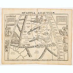
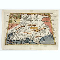
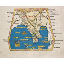
Tabula Asiae VIII (India & Central Asia with Monsters and Anthropomorphs)
The first edition of Munster's map of central Asia, based upon Claudius Ptolemy which appeared in his "Geographia Universalis", first published in 1540. This fa...
Place & Date: Basel, Heinrich Petri, 1545
Selling price: $300
Sold in 2014
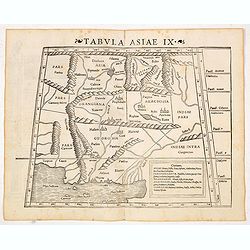
Tabula Asiae IX (Northern India and Pakistan)
The first edition of Munster's map of Northern India, present-day Iran, Afghanistan and Pakistan, with the delta of the Indus River graphically depicted. Based upon Claud...
Place & Date: Basel, Heinrich Petri, 1545
Selling price: $300
Sold in 2016