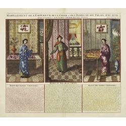
Habillement de l'Empereur de la Chine & des Dames de son Palais..
This impressive engraving is a wonderful example of Chatelain?s elegant plates.Divided in 3 panels, showing examples of costumes of Chinese ladies and those of the king o...
Place & Date: Amsterdam, ca. 1720
Selling price: $150
Sold
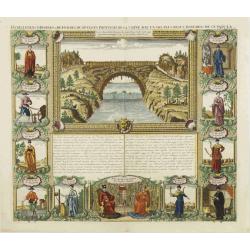
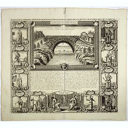
Habillemens d'Hommes et Femmes de diverses provinces de Chine..
This impressive engraving is a wonderful example of Chatelain?s elegant plates.Very nice view representing a bridge in the upper central part. Surrounded with panels show...
Place & Date: Amsterdam, ca. 1720
Selling price: $150
Sold
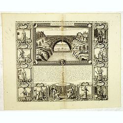
Habillemens d'hommes & de femmes de diverses provinces de la Chine. . .
An attractive view of the flying bridge in the province of Xensi, surrounded by 11 costume prints.The ethnographic studies show various types of people including physicia...
Place & Date: Amsterdam, 1720
Selling price: $100
Sold in 2012
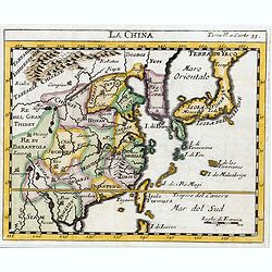
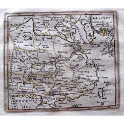
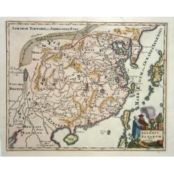
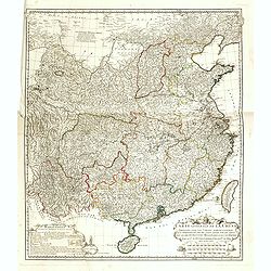
La Chine.
The map is of interest for the use of Sea of Japan / East Sea, the sea between Korea and Japan, here called "Mer Orientale".This small Italian map of China, Kor...
Place & Date: Venice, c.1722
Selling price: $450
Sold in 2023
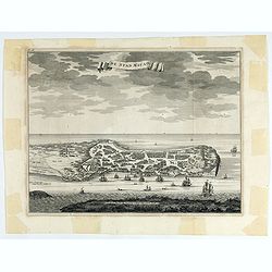
De Stad Macao.
A fine view of the city of Macao from Lappa Island showing the defenses, the forts, churches and convents: including Fort de Baare, Bon Parto, Fort St Paulo (Monte Fort)....
- $750 / ≈ €702
Place & Date: Amsterdam, 1724
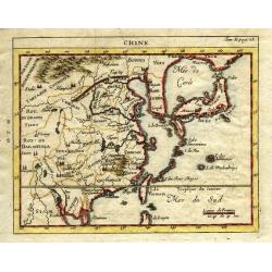
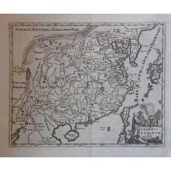
La Chine.
Scarce map based on a map published by Nicholas DeFer in Paris.
Place & Date: Antwerp, 1725
Selling price: $25
Sold in 2012
Chine.
Very uncommon state of Chevigni's map of China based on De L'Isle from "La Science des Personnes de la Cour..." published by Lottin, Genneau, and Morin. The map...
Place & Date: Paris, 1725
Selling price: $110
Sold in 2011
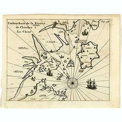
Embouchure de la rivière de Chincheo à la Chine.
This map is a view of Quanzhou Bay. Quanzhou was established in 718 during the Tang Dynasty (618–907). In those days, Guangzhou was China's greatest seaport, but this s...
Place & Date: Amsterdam, F. Bernard, 1725
Selling price: $110
Sold in 2014
La Chine, suivant les nouvelles observations..
Uncommon edition of this map of China. With decorative title cartouche lower right corner. Including the island of Taiwan.This example is unusual in having the additional...
Place & Date: Amsterdam 1728
Selling price: $540
Sold
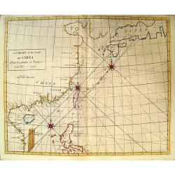
A Chart of the Coast of China.
Rare English chart of the China coast and seas by famed astronomer and comet tracker Edmond Halley. This chart comes from Halley's rare Atlas Maritimus et Commercialis. D...
Place & Date: London, 1728
Selling price: $4300
Sold in 2009
Habillemens d'hommes et de femmes de diverses provinces de la Chine avec un des plus beaux monumens de ce païs là.
In top a view of a bridge in Xensi Province bordered by eleven examples of Chinese dress from different provinces. Showing various people in their typical dress including...
Place & Date: Amsterdam, 1728
Selling price: $100
Sold in 2023
Paradigma XV Provinciarum et CLV Urbium Capitalium Sinensis Imperij Cum Templis...
Rare map of China from Stocklein's "Neuer Welt Bolt", a German translation of the Jesuit Lettres Edifiantes. Based on Philippe Couplet's map of 1686, the map sh...
Place & Date: Augsburg, 1729
Selling price: $750
Sold in 2010
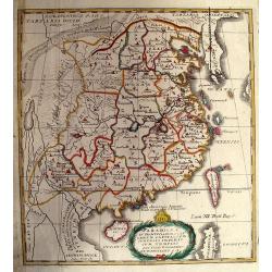
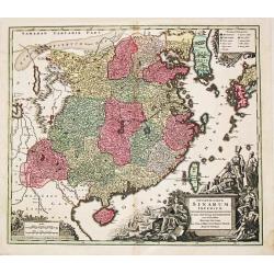
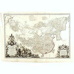
Imperii Sinarum
Map with a fair number of provinces & cities in the interior. The Great Wall is depicted along the northern border. A large fictitious interior lake labeled Kia Lacus...
Place & Date: Amsterdam 1729
Selling price: $300
Sold
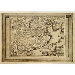
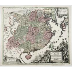
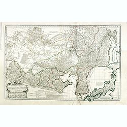
Imperii Sinarum.
Map of China. Along the northern border the Great Wall is visible. Note a large, fancyful lake named Kia Lacus which is the source of five large rivers. The map shows als...
Place & Date: Amsterdam, 1729
Selling price: $200
Sold in 2016
![[Antique map of China] Opulentissimum Sinarum Imperium](/uploads/cache/97974-250x250.jpg)
[Antique map of China] Opulentissimum Sinarum Imperium
A highly decorative and strongly engraved map of China that includes the islands of Hainan and Formosa (Taiwan), the Korean peninsula and western Japan.The cartography is...
Place & Date: Augsburg, ca 1730
Selling price: $1550
Sold in 2017
Opulentissimum Sinarum Imperium.
"Opulentissimum Sinarum Imperium". A highly decorative and strongly engraved map of China that includes the islands of Hainan and Formosa (Taiwan), the Korean p...
Place & Date: Nuernberg, ca 1730
Selling price: $425
Sold in 2021
Opulentissimum Sinarum Imperium juxta Recentissimam Delineationem in suas Provincias Disterminatum
A superb and detailed map of China, Korea, Taiwan and southern tip of Japan. Large, ornate decorative, cartouche symbolizing European trade with the East.Comes from M. Se...
Place & Date: Augsburg, 1730
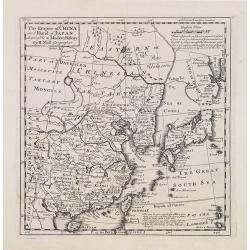
The Empire of China and Island of Japan, Agreeable to Modern History by H.Moll.
Map of China, Korea, Japan, the island Taiwan (Formosa I.). The map is of interest for the use of East Sea, the sea between Korea and Japan, here called "Sea of Core...
Place & Date: London, Thos. Bowles and John Bowles, 1729-1732
Selling price: $720
Sold
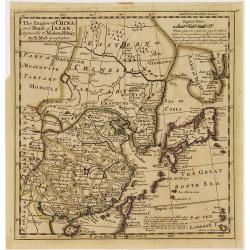
The Empire of China and Island of Japan, Agreeable to Modern History by H.Moll.
Map of China, Korea, Japan, the island Taiwan (Formosa I.). The map is of interest for the use of East Sea, the sea between Korea and Japan, here called "Sea of Kore...
Place & Date: London, Thos. Bowles and John Bowles, 1729-1732
Selling price: $600
Sold in 2010
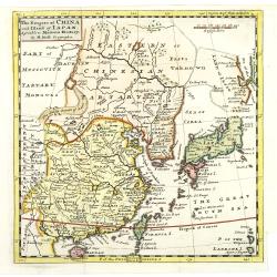
The Empire of China and Island of Japan, Agreeable to Modern History by H.Moll.
With page number 1 added in upper right corner of the scale. Map of China, Korea, Japan, the island Taiwan (Formosa I.). The map is of interest for the use of East Sea, t...
Place & Date: London, Thos. Bowles and John Bowles, 1729-1732
Selling price: $720
Sold
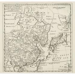
The Empire of China and Island of Japan, Agreeable to Modern History by H.Moll.
With page number 1 added in upper right corner of the scale. Map of China, Korea, Japan, the island Taiwan (Formosa I.). The map is of interest for the use of East Sea, t...
Place & Date: London, Thos. Bowles and John Bowles, 1729-1732
Selling price: $720
Sold
![[10 Maps] Carte generale du Thibet ou Bout-Tan et des Pays de Kashgar et Hami Dress'ee sur les Cartes et Memoires des RR PP Jesuites de la Chine . . .](/uploads/cache/29978-250x250.jpg)
[10 Maps] Carte generale du Thibet ou Bout-Tan et des Pays de Kashgar et Hami Dress'ee sur les Cartes et Memoires des RR PP Jesuites de la Chine . . .
A general map of Tibet together with 9 regional maps. The first accurate cartographic depiction of Tibet that is available in the western world. Jean Baptiste Bourguignon...
Place & Date: Paris, Le Mercier, 1735
Selling price: $1000
Sold in 2012
![[11 Maps] . . . Feuille particuliere de la Tartarie Chinoise. . .](/uploads/cache/29979-250x250.jpg)
[11 Maps] . . . Feuille particuliere de la Tartarie Chinoise. . .
A group of 11 maps, together forming a large map of Tartary. The first accurate cartographic depiction of Tartary available in the western world. Jean Baptiste Bourguigno...
Place & Date: Paris, Le Mercier, 1735
Selling price: $900
Sold in 2010
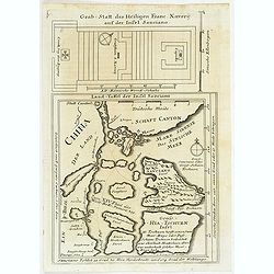
Land-Taffel der Insel Sanciano. Grab-Statt des Heiligen Franc. Xaverii auf der Insel Sanciano
A map (21,5:21 cm) of the southern coast of China with Macau, the Xiachuan Island and the Shangchuan Island, where Francis Xavier was buried. With the ground plan of Xavi...
Place & Date: Augsburg, 1735
Selling price: $130
Sold in 2011
Carte Generale de la Chine Dressée sur les Cartes Particulieres Que l' Empereur Chang-Hi a fait lever sur les lieux..
Large map showing the traditional limits of China, including Hainan and Formosa in the South, and Quantong and parts of the Gobi Desert in the North.As the title notes, t...
Place & Date: Paris , 1735
Selling price: $1750
Sold in 2016
Carte Generale De La Tartarie Chinoise Dressee sur les Cartes Particulieres Faits Sur Les Lieux Par Les R.R. P.P. Jesuites . . . .MDCCXXXII
D'Anville is very important for Korean cartography as he made the cartography of Korea widely available. The map is the first fairly accurate western map of Korea, though...
Place & Date: Paris, 1735
Selling price: $2500
Sold in 2018
Carte la plus generale et qui comprend la Chine, la Tartarie chinoise et le Thibet. . .
With a quite elaborately pictorial cartouche, engraved by G.Kondet. Very detailed map of China, Tibet and Korea. Jean Baptiste Bourguignon d' Anville (1697-1782), French ...
Place & Date: Paris, 1735
Selling price: $3000
Sold
![Province de Quang-Si. [Quang-si 广西 [Guangxi] province]](/uploads/cache/39686-250x250.jpg)
Province de Quang-Si. [Quang-si 广西 [Guangxi] province]
Important map of Quang-si 广西 [Guangxi] province. With a quite elaborately pictorial cartouche featuring a rococo chinoiserie ornamentation, engraved...
Place & Date: Paris, P.G. Le Mercier, 1735
Selling price: $170
Sold in 2020
![Province d'Yun-Nan. [Yun-nan 云南 [Yunnan] province.]](/uploads/cache/39687-250x250.jpg)
Province d'Yun-Nan. [Yun-nan 云南 [Yunnan] province.]
Important map of Yun-nan 云南 [Yunnan] province. With a quite elaborately pictorial cartouche featuring a rococo chinoiserie ornamentation, engraved b...
Place & Date: Paris, P.G. Le Mercier, 1735
Selling price: $250
Sold
![Province de Kiang-Nan. [Kiang-nan 江南 [Jiangnan] province.]](/uploads/cache/39690-250x250.jpg)
Province de Kiang-Nan. [Kiang-nan 江南 [Jiangnan] province.]
Important map of Kiang-nan 江南 [Jiangnan] province. With a quite elaborately pictorial cartouche featuring a rococo chinoiserie ornamentation, engrav...
Place & Date: Paris, P.G. Le Mercier, 1735
Selling price: $200
Sold in 2017
![Province de Chen-Si. [Chen-si 陕西 [Shaanxi] province.]](/uploads/cache/39698-250x250.jpg)
Province de Chen-Si. [Chen-si 陕西 [Shaanxi] province.]
Important map of Chen-si 陕西 [Shaanxi] province. With a quite elaborately pictorial cartouche, engraved by Guélard, the map by Delahaye, featuring a...
Place & Date: Paris, P.G. Le Mercier, 1735
Selling price: $400
Sold in 2017
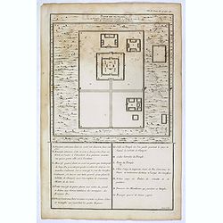
Plan du Ti-tang ou du temple, où l'empereur sacrifie à Chang-ti sous le titre de souverain seigneur de la terre
Nice example of d'Anville's plan of Tien-tang 天堂 [Tiantang] temple, from "Atlas général de la Chine..." prepared by Jesuit missionaries ...
Place & Date: Paris, P.G. Le Mercier, 1735
Selling price: $14
Sold in 2017
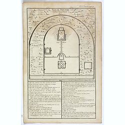
Plan du Tien-tang ou du temple, où l'empereur sacrifie à Chang-ti sous le titre de souverain seigneur de la terre.
Nice example of d'Anville's plan of Tien-tang 天堂 [Tiantang] temple, from "Atlas général de la Chine..."" prepared by Jesuit mission...
Place & Date: Paris, P.G. Le Mercier, 1735
Selling price: $8
Sold in 2017
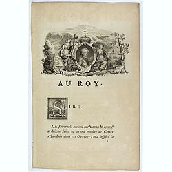
Dedication page to the King of France.
Text page showing an engraving (130x210mm.) of the young King followed by a letter addressed to him. Jean Baptiste Bourguignon d' Anville (1697-1782), French cartographer...
Place & Date: Paris, P.G. Le Mercier, 1735
Selling price: $27
Sold in 2018
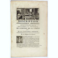
Description geographique, historique, chronologique, politique et physique de l'Empire de chine et de la Tartarie / De la Religion des Chinois.
Text page with a copper engraving (90x175mm.) showing an interior with Chinese persons. Jean Baptiste Bourguignon d' Anville (1697-1782), French cartographer. Compiled ov...
Place & Date: Paris, P.G. Le Mercier, 1735
Selling price: $10
Sold in 2018
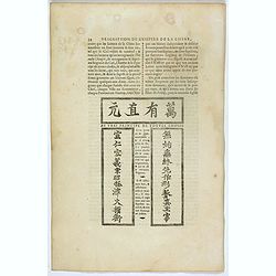
Au vrai principe de toutes choses.
Text page with an engraving. Jean Baptiste Bourguignon d' Anville (1697-1782), French cartographer. Compiled over 200 maps. This map is from his most important work Nou...
Place & Date: Paris, P.G. Le Mercier, 1735
Selling price: $20
Sold in 2017
Villes de la province de Tche-kiang. (Hang-tcheou-fou, Ping hou hien, Hou-tcheou-fou, Hia-hing-fou and Ku-tcheou-fou.)
Five towns plans : Hang-tcheou-fou, Ping hou hien, Hou-tcheou-fou, Hia-hing-fou and Ku-tcheou-fou.From "Description geographique, historique, chronologique, politiqu...
Place & Date: Paris, P.G. Le Mercier, 1735
Selling price: $25
Sold in 2022
Villes de la province de Kiang-nan.
Eight town plans : Nan-king, Sou-tcheou-fou, Koen-chan-hien, Tsi-ki-hien, Vou-si-hien, Kia-ting-hien, Tchan-chou-hien and Tsing-pou-hien.From "Description geographiq...
Place & Date: Paris, P.G. Le Mercier, 1735
Selling price: $25
Sold in 2022
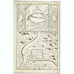
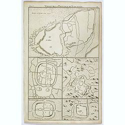
Villes de la province de Hou-Quang.
4 town plans : Yong-tcheou-fou, Vou-tchang-fou, Hoang tcheou fou and Siang-yang-fou. From "Description geographique, historique, chronologique, politique, et physiqu...
Place & Date: Paris, P.G. Le Mercier, 1735
Selling price: $25
Sold in 2022
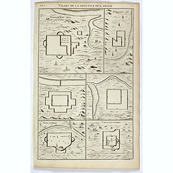
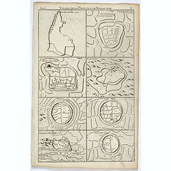
Villes de la province de Chensi.
Six town plans : Si-ngan-fou, capitale…, Tchouang-lan, Lan-tcheou, Can-tcheou, King-tcheou and Cou-yuen-tcheou. From "Description geographique, historique, chronol...
Place & Date: Paris, P.G. Le Mercier, 1735
Selling price: $25
Sold in 2017