Browse Listings in Asia
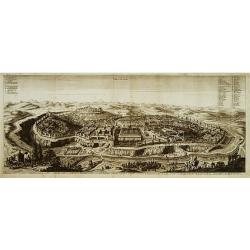
Ierusalem.
A panoramic view of the holy city of Jerusalem. With 52 descriptive points key in German and Latin.From: Dapper, Olfert Naukeurige beschryving van gantsch Syrie en Palest...
Place & Date: Amsterdam 1677.
Selling price: $350
Sold
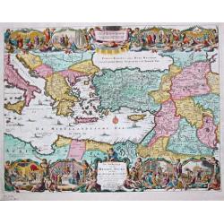
Perigrinatie ofte Veertich-jarige Reyse der Kinderen Israels.
Dutch so-called "Staten" bibles, published between 1637 and c. 1760, contained 5 maps: The World, "Paradise", The Perigrinations, The Promised Land Ca...
Place & Date: H. Keur en M. Doornik, Dordrecht-Amsterdam, 1686.
Selling price: $200
Sold
Jerusalem.
Dutch so-called "Staten" bibles, published between 1637 and c. 1760, contained 5 maps: The World, "Paradise", The Perigrinations, The Promised Land Ca...
Place & Date: Amsterdam, 1690.
Selling price: $150
Sold
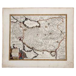
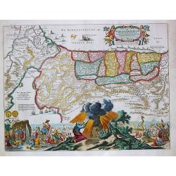
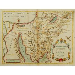
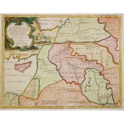
ROYAUME de PERSE avec les Pays Limitrophes et les Places maritimes, suivant les Relations des meilleurs Voyageurs nouvellement.
An attractive hand colored copper engraved map of the old Persian Empire, or modern-day Iran, published in 1719 in Leiden by Pieter van der Aa in the "Les Voyages du...
Place & Date: Leiden, ca 1719
Selling price: $65
Sold in 2019
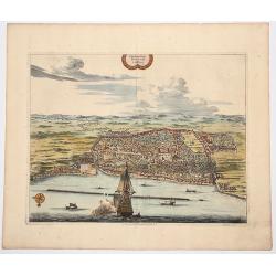
La Ville de l' AMBOINE, Capitale des Isles Molucques.
An attractive hand colored copperplate view of Ambon (Moluccas) by Pierre van der Aa. Shows the capital of Ambon Island with several ships in foreground during the the Du...
Place & Date: Leiden, ca 1719
Selling price: $100
Sold in 2019
Plan de la Ville de BANTAM, dans l'isle de Java.
An attractive hand colored copperplate view of Bantam by Pierre van der Aa. Shows the village with several ships in foreground during the the Dutch 'golden age' in Indone...
Place & Date: Leiden, ca 1719
Selling price: $150
Sold in 2019
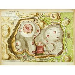
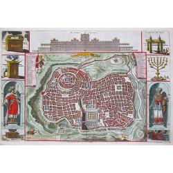
Description de l'ancienne Jerusalem selon Villalpand.
Richly detailed imaginary plan of ancient Jerusalem seen from the east. At bottom center of the plan itself, the Temple of Solomon is shown: upper left, the City of David...
Place & Date: [Paris ca. 1730]
Selling price: $180
Sold
A Map of the Children of Israel's Travels and Marches?
From Augustin Antoine Calmet, A historical, geographical?dictionary of the Holy Bible, London, 1732. Vol. I, between PP. 384-385.
Place & Date: [London 1732]
Selling price: $350
Sold
Afbeelding van all de Landen gelegen tusschen de Middellandsche, Zwarte, Caspische, Persische en Rode Zeën.
Willem Albert Bachiene (1712-1783), Dutch geographer in Maastricht. Most important work ' Heilige Geographie', a work on the Holy Land. Mathijs Schalenkamp published in 1...
Place & Date: Gorichem, Nicolaas Goetzee, 1748.
Selling price: $160
Sold

Voyage of his majesty’s ship Alceste, along the Coast of Corea, to the island of Lewchew, with an account of her subsequent shipwreck, by John M’LEOD. Surgeon of the Alceste.
Second and best edition, with frontispiece portrait of Captain Maxwell and five fine hand-colored aquatint plates, including a plate not present in the first edition of t...
Place & Date: London, John Murray, 1818
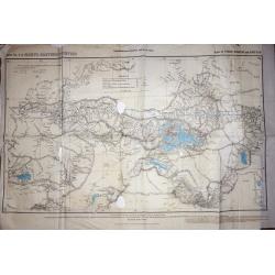
Trigonometrical Branch Survey of India, Sheet No6 of North Eastern Frontier Parts of Tibet, Sikhim and Bhutan
A well-used map of the area surrounding Lhasa. Published under the direction of Colonel G. C. De Pree, Surveyor General of India.
Place & Date: Dehra Dun, 1885
Selling price: $210
Sold in 2016
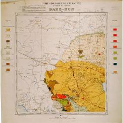
Carte geologique de l'Indochine. Bang-Kok est.
Geological or soil map showing part of Bangkok , including in the left and right margins a colored legend with signs of the different geological ages. Heliography and pri...
Place & Date: Service geographique de l'Indochine, fevrier 1939.
Selling price: $310
Sold in 2009
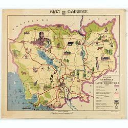
Royaume du Cambodge, carte touristique.
Decorative pictorial and Tourist map with points of interest shown pictorially. Figures monuments, animals, and beaches. Scale 1:1,000,000. Tite in upper margin, key at l...
Place & Date: [Phnom Penh, Service ge´ographique des F.A.N.K., 1968]
Selling price: $650
Sold in 2020
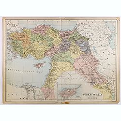
Turkey in Asia.
Very detailed map of Turkey. Inset of Cyprus. The map was printed from lithographic stones taken from a hand-engraved steel plate. The cartographer John Bartholomew of Ed...
Place & Date: Edinburg
Selling price: $100
Sold in 2017
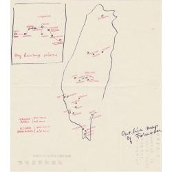
Outline map of Formosa.
An unusual hand drawn map of Formosa.
Place & Date: Kagi City, Formosa
Selling price: $50
Sold in 2019
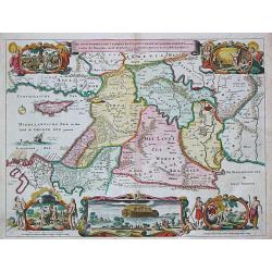
De Gelegentheyt van t' Paradys en t' Landt Canaan, mitsgaders d' eerst bewoonde Landen der Patriarchen.
Dutch so-called "Staten" bibles, published between 1637 and c. 1760, contained 5 maps: The World, "Paradise", The Perigrinations, The Promised Land Ca...
Place & Date: Amsterdam / Dordrecht, Pieter Keur, Pieter Rotterdam em Pieter Rotterd
Selling price: $201
Sold
De Beschryving van de Reysen Pauli en Van de Andere Apostelen.
The Dutch so-called ' Staten' bibles published between 1637 and c. 1760, contained 5 maps: The World, ' Paradise', The Perigrinations, The Promised Land Canaan, The Trave...
Place & Date: Amsterdam / Dordrecht, Pieter Keur, Pieter Rotterdam en Pieter Rotterd
Selling price: $225
Sold
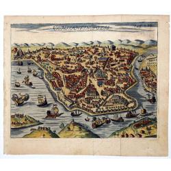
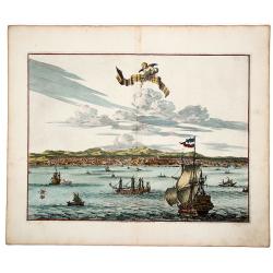
CONSTANTINOPOLIS.
A striking view of Constantinopolis showing ships and the town's discrits. Folded as issued. On upper right "Pag. 293".
Place & Date: 18th century
Selling price: $200
Sold in 2020