Browse Listings in Asia
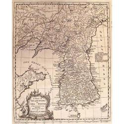
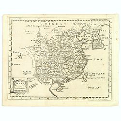
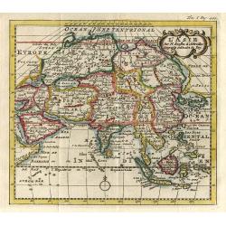
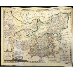
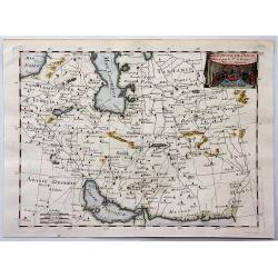
A MAP OF QUAN-TONG OR LEA-TONGE PROVINCE and the KINGDOM OF KAU-LI OR COREA.
Detailed map of Korea, Liaodong, and the tip of Shandong Province prepared by Thomas Kitchin for Thomas Salmon's Universal Traveller, based on D'Anville's landmark map of...
Date: LONDON, 1753
Selling price: ????
Please login to see price!
Sold in 2010
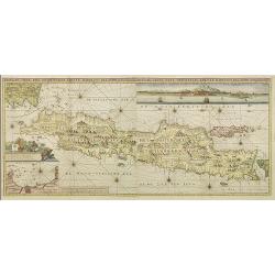
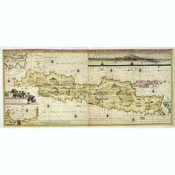
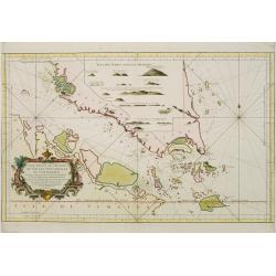
Insulae Java Pars Occidentalis Edente Hadriano Relando. . .
Second state of this finely engraved and detailed chart of Java important for its Dutch trading connections - annotated panels, clearly indicated rice fields, mountains, ...
Date: Amsterdam, 1753
Selling price: ????
Please login to see price!
Sold
![[2 charts] Kaart van Pulo Condor, of het Eiland Condor.. / Paskaart van de Baay van Padaran op de Kust van Tsiompa..](/uploads/cache/31196-250x250.jpg)
[2 charts] Kaart van Pulo Condor, of het Eiland Condor.. / Paskaart van de Baay van Padaran op de Kust van Tsiompa..
Two finely engraved and detailed charts of Condor Island and the Bay of Pandaran near Vietnam.Latitude scale, compass rose and system of rhumb lines, soundings, anchorage...
Date: Amsterdam, 1753
Selling price: ????
Please login to see price!
Sold in 2011
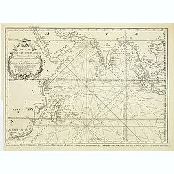
Carte de L'Ocean Oriental ou Mer des Indes..
Detailed map of the Indian Ocean depicting incomplete coastline for Western Australia marked with seven place names, including 'Baye des Chiens Marins veue par Dampierre ...
Date: Paris, 1753
Selling price: ????
Please login to see price!
Sold in 2011
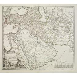
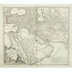
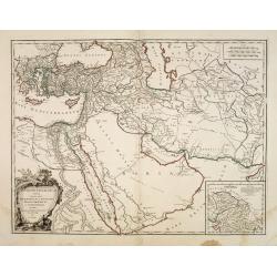
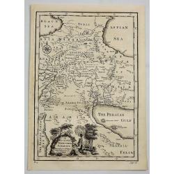
Etats du Grand Seigneur en Asie Pays des Usbecs, Arabie et Egypte. . .
Beautifully engraved map of the Arabian peninsula and Turkey printed by Robert de Vaugondy. Ornamental title cartouche on the lower left corner of two figures one of whic...
Date: Paris, 1753
Selling price: ????
Please login to see price!
Sold
Etats du Grand Seigneur en Asie Pays des Usbecs, Arabie et Egypte. . .
Beautifully engraved map of the Arabian peninsula and Turkey printed by Robert de Vaugondy. Ornamental title cartouche on the lower left corner of two figures one of whic...
Date: Paris, 1753
Selling price: ????
Please login to see price!
Sold in 2011
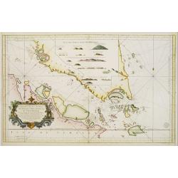
Insulae Java Pars Occidentalis Edente Hadriano Relando. . .
Second state of this finely engraved and detailed chart of Java important for its Dutch trading connections - annotated panels, clearly indicated rice fields, mountains, ...
Date: Amsterdam, ca. 1753
Selling price: ????
Please login to see price!
Sold in 2018
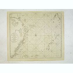
Pas-Kaaart van de Haven van Nangasequi.
A rare and finely engraved and detailed chart of Nagasaki.Latitude scale, compass rose and system of rhumb lines, soundings, anchorage's, etc.Very rare: only included in ...
Date: Amsterdam, 1753
Selling price: ????
Please login to see price!
Sold
Antiquor Imperiorum tabula, in quâ prae caeteris, Macedonium seu Alexandri. . .
Ancient map showing the Caspian Sea in the north, in the west to show Greece, east to the Indus River, and south to include the Red Sea and the Nile River valley. Almost ...
Date: Paris, 1753
Selling price: ????
Please login to see price!
Sold in 2015
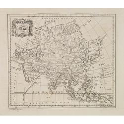
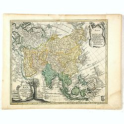
Asia.
Map of Asia from "The universal traveler or a complete description of the several foreign nations of the world" by Richard Baldwin. The work was written by Thom...
Date: London, 1752-1753
Selling price: ????
Please login to see price!
Sold
Asia.
Uncommon miniature map from Gibson's "Atlas Minimus, or a New Set of Pocket Maps of the several Empires, Kingdoms, and States of the known World." John Gibson (...
Date: London, 1752-1753
Selling price: ????
Please login to see price!
Sold in 2013
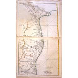
Cormandel.
A large map on two sheets showing the east coast of the Indian peninsula. Covers from Narsapur to Nagapatinam. Includes the cities of Medapili, Kistenapatam, Arimegon, an...
Date: Paris, 1753
Selling price: ????
Please login to see price!
Sold in 2016
Tab: Georg : Asiae ad emendatiora quae ad huc prodierunt exempla jussu Acad. Reg. Scient. et eleg. Litt. Pruss. descripta.
Detailed and scarce map of Asia, published in "Geographischer Atlas bestehend in 44 Land-Charten, worauf alle Theile des Erd-Creyses vorgestellet werden" and ma...
Date: Berlin, 1753
Selling price: ????
Please login to see price!
Sold in 2023
Tab: Georg : Asiae ad emendatiora quae ad huc prodierunt exempla jussu Acad. Reg. Scient. et eleg. Litt. Pruss. descripta.
Detailed and scarce map of Asia, published in "Geographischer Atlas bestehend in 44 Land-Charten, worauf alle Theile des Erd-Creyses vorgestellet werden" and ma...
Date: Berlin, 1753
Selling price: ????
Please login to see price!
Sold in 2016
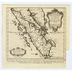
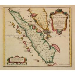
Carte de l'Isle de Sumatra. . . / Kaart van het Eiland Sumatra. . .
Map of Sumatra, also showing the tip of the Malay Peninsula and the Straits of Singapore. An unusually detailed map of the area, showing many coastal features, shoals, ba...
Date: The Hague, 1753
Selling price: ????
Please login to see price!
Sold in 2019
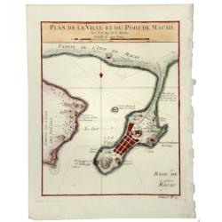
PLAN DE LA VILLE ET DU PORT DE MACAO.
A fine early map of Macao, published by Nicholas Bellin, the French Royal Hydrographer.
Date: Paris, 1753
Selling price: ????
Please login to see price!
Sold in 2020
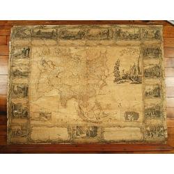
L'Asie divissée en tous ses etats,..
Uncommon wall map of the continent of Asia with some period color, composed from four joined sheets surrounded by text and vignettes printed on separate sheets.Published ...
Date: Paris 1754
Selling price: ????
Please login to see price!
Sold
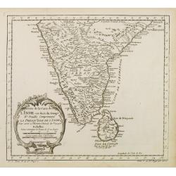
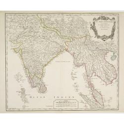
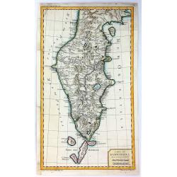
Suite de la Carte de L'Inde en deca du Gange..
A good engraved map of India with Sri Lanka, with rococo title cartouche lower left. From l'Histoire générale des voyages .
Date: Paris 1754
Selling price: ????
Please login to see price!
Sold
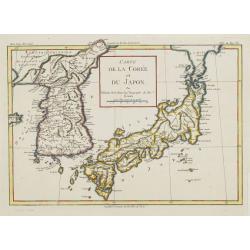
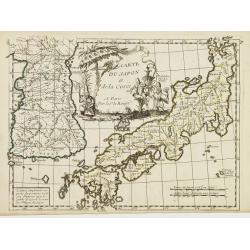
Carte de la Corée et du Japon. Par M.Brion de la Tour Ing.r Geographe du Roi.
Rare map of Japan and Korea prepared by Brion de la Tour.
Date: Paris, 1754
Selling price: ????
Please login to see price!
Sold in 2008
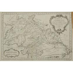
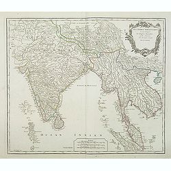
Carte de L'Indoustan ...
From l'Histoire générale des voyages. Prepared by Jacques Nicholas Bellin (1703-1772), one of the most important and proficient French cartographers of the mid-eighteen...
Date: Paris, 1754
Selling price: ????
Please login to see price!
Sold in 2011
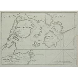
Carte de la Baye de Chin-Chew ...
A detailed small chart of the estuary of the Chiu-lung River at present-day Hsia-men, on the mainland coast, adjacent to Taiwan, showing the location of a few village set...
Date: Paris, 1754
Selling price: ????
Please login to see price!
Sold in 2011
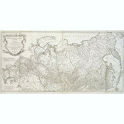
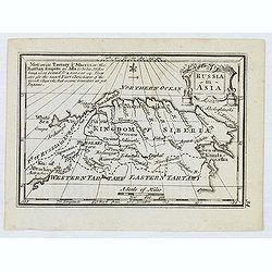
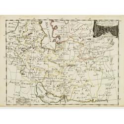
Troisième partie de la carte d'Asie, contenant la Sibérie, et quelques autres parties de la Tartarie. . .
Engraved map of Tartary on two sheets, with country boundaries in out line color. Includes geographic notes and ornamental cartouche by "H. Gravelot, invenit., DeLaf...
Date: Paris, 1754
Selling price: ????
Please login to see price!
Sold in 2012
KejserDommet China udkastet til den almindelige Reise-beskrivelse af N. Bellin Ing. de la Mar. 1748.
Extremely rare Danish issue of Bellin's three cartouche map of China. Bellin added this map to the Prevost itinerary, which has been published in French, Dutch, German, a...
Date: Copenhagen, 1754
Selling price: ????
Please login to see price!
Sold in 2013
An Accurate Map of Asia According to the Latest Authorities by Emanuel Bowen.
An attractive map of Asia by Emanuel Bowen, includes Russia, China, Japan, India, the Malay peninsula, and much more.
Date: London, 1754
Selling price: ????
Please login to see price!
Sold in 2012
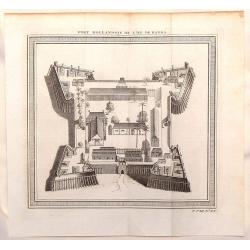
Fort Hollandois de L'Isle de Banda.
Striking view of Fort Nassau Banda which is on the Maluku Islands in Indonesia. The fortification view is from "HISTOIRE GENERALE DES VOYAGES". Jacques Nicola...
Date: Paris, 1754
Selling price: ????
Please login to see price!
Sold in 2014
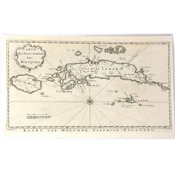
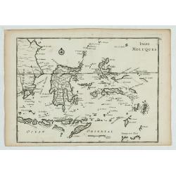
Carte des isles voisines des Moluques
A striking antique map of the Ceram, Ambon and the Banda islands close to Indonesia. Published by Antonine de Prevost d' Exile's “Histoire Generale des Voyages”. (Fro...
Date: Amsterdam, 1754
Selling price: ????
Please login to see price!
Sold in 2019
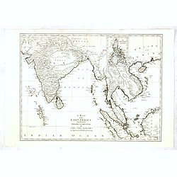
A Map of the East Indies from the latest Authorities and Observations....
Uncommon detailed map of South East Asia, India, and part of China, extending to Tibet, the Maladies, Sumatra, part of Borneo, Hainan, Kanton, etc.In upper right inset of...
Date: London, 1754
Selling price: ????
Please login to see price!
Sold in 2017
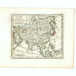
L'Asie Divisée selon ses differens Etats.
Small detailed map of Asia. From Atlas Portatif Universel, by Robert de Vaugondy.Page 160 outside border top right. State 2, title changed: "Par le Sr. Robert de Vau...
Date: Paris, 1754
Selling price: ????
Please login to see price!
Sold in 2017
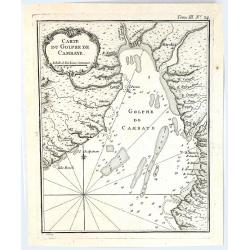
Carte du Golphe de Cambaye.
A quaint little map of India, featuring the Gulf of Cambay (Gulf of Khambhat) India, published in “Le Petit Atlas Martime” published by Bellin in 1764. Featuring a f...
Date: Paris, 1754
Selling price: ????
Please login to see price!
Sold in 2016
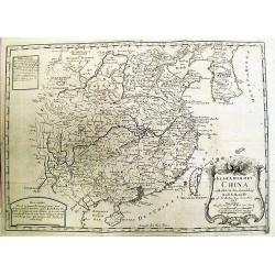
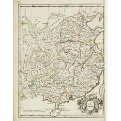
China.
A nice mid-eighteenth century map of China, extending from the island of Haynan in the south, to the Kobi Desert in the north, from Lake Puka in Tibet in the west to Kore...
Date: London, ca. 1754
Selling price: ????
Please login to see price!
Sold in 2017
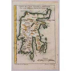
Carte de L'Isle Celebes ou Macassar.
A fine little copper engraved map of Celebes Island, Makassar.
Date: Paris, 1754
Selling price: ????
Please login to see price!
Sold in 2018
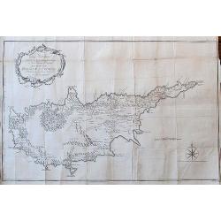
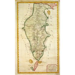
To George Wakeman Esq, Consul for his Majesty the King of Great Britain in the Island of Cyprus. This Map of the Island of Cyprus is dedicated by his friend and servant A. Drummond.
A rare large scale map Cyprus. It is one of the most important cartographic sources of Cyprus during the Turkish occupation in the 18th century. Curiously, some place-nam...
Date: London, 1754
Selling price: ????
Please login to see price!
Sold in 2018
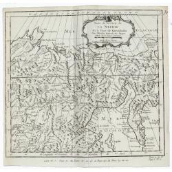
Suite de la Carte de la Siberie Et le Pays de Kamtschatka.
A detailed 1754 Bellin engraved map of eastern Siberia above and below the Arctic Circle, showing the Sea of Okhotsk, the Kamchatka Peninsula, and Sakhalin Island. The ma...
Date: Paris, 1754
Selling price: ????
Please login to see price!
Sold in 2019
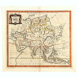
L' Asie.
This is a map from: Discours sur l' Histoire Universellean encyclopedia published in Amsterdam in 1755 this map is based on Sanson's cartography.
Date: Amsterdam 1755
Selling price: ????
Please login to see price!
Sold
Les Indes Orientales, ou sount distingues les Empires et Royaumes..
Interesting regional map extending from India, the Ganges and the Maldive Islands to Hai-nan, Cochinchina, Malacca and Sumatra. Includes islands, towns, mountains, rivers...
Date: Paris 1755
Selling price: ????
Please login to see price!
Sold
Carte du Kamtchatka.
Jaques Nicolas Bellin (1702-720) was the most important French hydrographer of the 18th century. Sea-atlas 'Hydrographique Français' , 1756-65, atlas to accompany Prévo...
Date: Paris, c. 1755
Selling price: ????
Please login to see price!
Sold in 2016
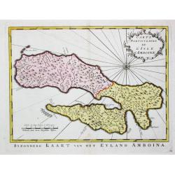
Carte Particulare de l' Isle d' Amboine.
Jaques Nicolas Bellin (1702-720) was the most important French hydrographer of the 18th century. Sea-atlas 'Hydrographique Français' , 1756-65, atlas to accompany Prévo...
Date: Amsterdam, c. 1755
Selling price: ????
Please login to see price!
Sold in 2009
Carte Réduite duite des Detroits de Malaca, Sincapour, et du gouverneur
Attractive large chart showing Malay Peninsula from north of Selangor to Pulor Tioman with adjacent coast of Sumatra and the islands southwards to Lingga. Latitude and lo...
Date: Paris 1755
Selling price: ????
Please login to see price!
Sold
Carte d L' Isle de Sumatra.
Jaques Nicolas Bellin (1702-720) was the most important French hydrographer of the 18th century. Sea-atlas 'Hydrographique Français' , 1756-65, atlas to accompany Prévo...
Date: Paris, c. 1755
Selling price: ????
Please login to see price!
Sold in 2008
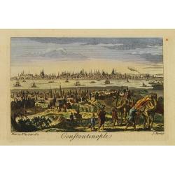
Constantinople.
Decorative engraving from Thomas Salmon's The Universal Traveller .
Date: London 1755
Selling price: ????
Please login to see price!
Sold
Carte Réduite des Detroits de Malaca, Sincapour..
Attractive large showing Malay Peninsula from north of Selangor to Pulor Tioman with adjacent coast of Sumatra and the islands southwards to Lingga. Latitude and longitu...
Date: Paris 1755
Selling price: ????
Please login to see price!
Sold
Nieuwe Kaart van het Oostelyckste Deel der Weereld.
Izaak Tirion (d. 1769) Amsterdam publisher. His ' Nieuwe en beknopte handatlas' saw 6 editions between before 1740 and after 1784. Also ' Tegenwoordige staat van alle vol...
Date: Amsterdam, 1755
Selling price: ????
Please login to see price!
Sold in 2009
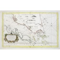
Carte Réduite des Detroits de Malaca, Sincapour, et du gouverneur
Attractive large chart showing Malay Peninsula from north of Selangor to Pulor Tioman with adjacent coast of Sumatra and the islands southwards to Lingga. Latitude and lo...
Date: Paris, 1755
Selling price: ????
Please login to see price!
Sold
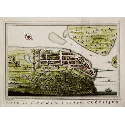
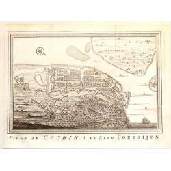
Ville de Cochin / De Stad Coetsijen.
Jaques Nicolas Bellin (1702-720) was the most important French hydrographer of the 18th century. Sea-atlas 'Hydrographique Français' , 1756-65, atlas to accompany Prévo...
Date: Amsterdam, c. 1755
Selling price: ????
Please login to see price!
Sold
Tatariae Sinensis mappa Geographica. . .
A fine large-scale map derived from d'Anville and prepared by Johann Tobias Mayer . Including far western China and Mongolia, Japan, Korea and Manchuria. Dense with old p...
Date: Nuremberg, 1755
Selling price: ????
Please login to see price!
Sold in 2011
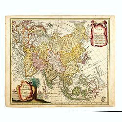
Carte de L'Asie dressée sur les Relations les plus nouvelles principalement. . .
Detailed map of Asia from the Atlas Universel , first published in 1755. The map is detailed, precisely engraved and not given to the fanciful cartography being promoted ...
Date: Paris, 1755
Selling price: ????
Please login to see price!
Sold
Les Indes Orientales, ou sont distingues les Empires et Royaumes. . .
Interesting regional map extending from India, the Ganges and the Maldive Islands to Hai-nan, Cochinchina, Malacca and Sumatra. Includes islands, "Sinca poura" ...
Date: Paris, ca. 1755
Selling price: ????
Please login to see price!
Sold in 2021
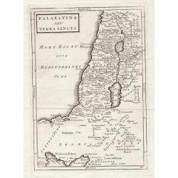
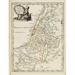
Palaestina S.EU Terra Sancta.
Map of Palaestina by Christoph Cellarius, from "Geographia Antiqua". Highly detailed map of the area.
Date: Leipzig, 1755
Selling price: ????
Please login to see price!
Sold in 2012
![[Two maps] Tatariae Sinensis mappa Geographica... [together with] Regni Sinae vel Sinae propriae. . .](/uploads/cache/33797-250x250.jpg)
[Two maps] Tatariae Sinensis mappa Geographica... [together with] Regni Sinae vel Sinae propriae. . .
Tatariae Sinensis mappa Geographica A fine large-scale map derived from d'Anville and prepared by Johann Tobias Mayer . Including far western China and Mongolia, Japan, K...
Date: Nuremberg, 1755
Selling price: ????
Please login to see price!
Sold in 2013
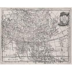
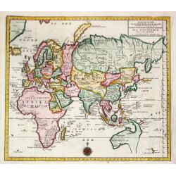
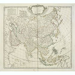
Asia
Detailed map of Asia engraved by John Gibson for "The Gentleman's Magazine", founded by visionary Edward Cave, was the world's first monthly general interest ma...
Date: London, ca. 1755
Selling price: ????
Please login to see price!
Sold in 2015
Ville de Cochin de Stad Coestsijen.
Striking copper engraving of Kochi, a major port city on the west coast of India. It has been considered as the center of the Indian spice trade for centuries. It was fir...
Date: Amsterdam, 1755
Selling price: ????
Please login to see price!
Sold in 2018
Carte du Kamtchatka.
A striking map of the Kamchatkan peninsula, that provides a detailed view of the topography with mountains, rivers, lakes, roads and settlements carefully noted. Not many...
Date: Paris, 1755
Selling price: ????
Please login to see price!
Sold in 2016
Carte des cotes de l'Hindoustan depuis Bombay jusqu'à Godavery . . .
A well engraved and highly detailed chart that was prepared by M. Daussy. Engraved by Chassant, engraver for the Depot Générale de la marine is noted as such on the map...
Date: Paris, 1755
Selling price: ????
Please login to see price!
Sold in 2016
History of China, the Modern History, By Way of Sequel to Mr. Rollin's Ancient History.
A rare book translated from French and printed for J.& P. Knapton. The volume is divided into a number of parts, covering a general history of China; a description of...
Date: London, 1755
Selling price: ????
Please login to see price!
Sold in 2018
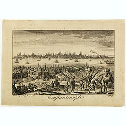
Constantinople.
Decorative engraving by James Mynde (fl.1720-1760) from Thomas Salmon's The Universal Traveller .
Date: London 1755
Selling price: ????
Please login to see price!
Sold in 2020
Waher Abriss der Stadt Bethlehem. . .
A magnificent panoramic view of the city of Bethlehem described as "true" and "accurate" based on the work of monk of the Strasbourg Province of the F...
Date: Augsburg, 1755
Selling price: ????
Please login to see price!
Sold in 2019
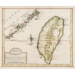
L'Isle Formose et parties des Costes de la Chine..
This well-known map of Taiwan is prepared by Jacques Nicolas Bellin and was based on Jesuit information. The text along the island's east-coast claims: Of this coast litt...
Date: Paris, 1756
Selling price: ????
Please login to see price!
Sold in 2019
L' Empire des Turcs.
Fine map of the Ottoman Empire. Presenting a decorative title cartouche and an inset illustrating the western part of Magreb. George Louis Le Rouge was active from 1740- ...
Date: Paris 1756
Selling price: ????
Please login to see price!
Sold
La Palestine ou la Terre Sainte divisée en dix Tribus..
Fine map of Palestine with ten tribal territories outlined in color. A helmeted female figure holds the garlanded title cartouche.George Louis Le Rouge was active from 17...
Date: Paris 1756
Selling price: ????
Please login to see price!
Sold
L'Empire de Perse.
Fine map of Persia. With decorative title cartouche. George Louis Le Rouge was active from 1740- till 1780 as a publisher, and was appointed engineer for the King of Fran...
Date: Paris 1756
Selling price: ????
Please login to see price!
Sold
La Chine.
Fine map of China, with in lower right corner Taiwan and a large decorative title cartouche. George Louis Le Rouge was active from 1740- till 1780 as a publisher, and was...
Date: Paris, 1756
Selling price: ????
Please login to see price!
Sold
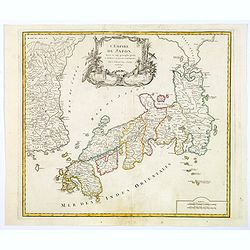
Carte du Japon et de la Corée.
Neat map of Japan, less Hokkaido but including the Korean peninsula, with a large figured cartouche at top center. A note reads to the effect that Le Rouge has simplified...
Date: Paris, 1756
Selling price: ????
Please login to see price!
Sold in 2008
Isles Moluques.
A scarce little map depicting European knowledge of Sulawesi, part of Borneo and the Spice Islands at the time of publication.George Louis Le Rouge was active from 1740- ...
Date: Paris, 1756
Selling price: ????
Please login to see price!
Sold in 2009
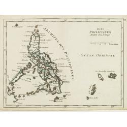
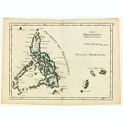
Isles Philippines.
Fine map of the Philippines. George Louis Le Rouge was active from 1740- till 1780 as a publisher, and was appointed engineer for the King of France. From his Atlas Nouve...
Date: Paris, 1756
Selling price: ????
Please login to see price!
Sold in 2015
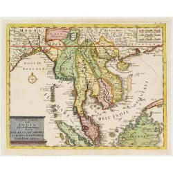
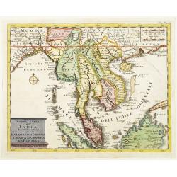
Nuova carte dell' India di là del Fiume Ganges overo di Malacca Siam Cambodia Chiampa KoChinchina Laos Pegu ava&c.
Fine map of Malay Peninsular, with present-day Thailand, taken from Storia moderna di tutti I popoli del mondo , edited by Thomas Salmon. A Italian edition of this famous...
Date: Venice 1740-1756
Selling price: ????
Please login to see price!
Sold
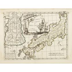
Carte du Japon et de la Corée.
Neat map of Japan, less Hokkaido but including the Korean peninsula, with a large figured cartouche at top centre. A note reads to the effect that Le Rouge has simplified...
Date: Paris 1756
Selling price: ????
Please login to see price!
Sold in 2008
L'Empire de Perse.
Detailed map showing the Persian Empire, from Tartaria and the Caspian Sea to the Indian Ocean and Persian Gulf. With decorative title cartouche featuring a vignette at t...
Date: Paris, 1756
Selling price: ????
Please login to see price!
Sold in 2018
Nuova carte dell' India di là del Fiume Ganges overo di Malacca Siam Cambodia Chiampa KoChinchina Laos Pegu ava&c.
Fine map of Malay Peninsular, with present-day Thailand, taken from Storia moderna di tutti I popoli del mondo , edited by Thomas Salmon. A Italian edition of this famous...
Date: Venice, 1740-1756
Selling price: ????
Please login to see price!
Sold in 2013
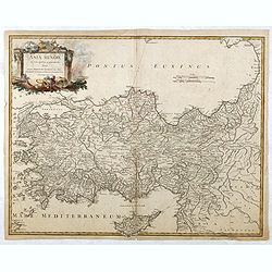
Asia Minor in suas partes seu provincias divisa. . . (Turkey with Cyprus)
Detailed map of Ancient Turkey with Cyprus from his "Atlas Universel".Gilles Robert de Vaugondy (1688–1766), also known as Le Sieur or Monsieur Robert, and hi...
Date: Paris, 1756
Selling price: ????
Please login to see price!
Sold in 2015
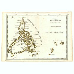
Isles Philippines.
Fine map of the Philippines. George Louis Le Rouge was active from 1740- till 1780 as a publisher, and was appointed engineer for the King of France. From his Atlas Nouve...
Date: Paris, 1756
Selling price: ????
Please login to see price!
Sold in 2016
L'Empire du Japon. . .
Very similar to Joan Blaeu's map of 100 years previously: Europeans by then had been expelled, except the Dutch, whose movements were so curtailed that they were not able...
Date: Paris, 1756
Selling price: ????
Please login to see price!
Sold in 2019
Isles Philippines.
Fine map of the Philippines. George Louis Le Rouge was active from 1740- till 1780 as a publisher, and was appointed engineer for the King of France. From his Atlas Nouve...
Date: Paris, 1756
Selling price: ????
Please login to see price!
Sold in 2018
A Map of Ancient Aegypt from Celarius.
A fine map of Ancient Egypt with its cities and topography. There is a decorative title cartouche in the shape of a pyramid, surrounded by ancient Egyptian antiquities su...
Date: London, 1756
Selling price: ????
Please login to see price!
Sold in 2021
A Map of Canaan Divided Among the Twelve Tribes.
An Old Testament Israel showing its twelve divisions according to the tribes. With a decorative title cartouche depicting the Ark of the Covenant, various temple tools an...
Date: London, 1756
Selling price: ????
Please login to see price!
Sold in 2019
A Map of the Terrestrial Paradise According to Mr. Huet with Improvements from Dr. Wells.
A map of the Ancient Near East, showing ancient cities, kingdoms, and pinpointing the site of the Garden of Eden. With a decorative title cartouche featuring Eden and Ada...
Date: London, 1756
Selling price: ????
Please login to see price!
Sold in 2020
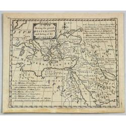
A Map Shewing the General Dispersion and Settling of the Nations.
A fine map of The Eastern Mediterranean, Arabia and part of North Africa, illustrating the area that was settled by the three sons of Noah (Sem, Ham & Japeth) after t...
Date: London, 1756
Selling price: ????
Please login to see price!
Sold in 2021
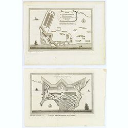
Plan de la Forteresse de Coylan / Plan de la Forteresse de Cranganor. . .
The first of a pair of Indian prints is a rare map of the fort of Kollam, Kerala, on India's (east) Malabar Coast by the French cartographer N. Bellin. Kollam, or as it i...
Date: Paris, ca 1756
Selling price: ????
Please login to see price!
Sold in 2019
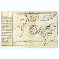
A Plan of the Town & Fortress of Garlah belonging to Angria the Admiral to the Jahou Rajah on the Coast of Mallabar.
A very interesting bird's eye view of the fort and surrounds. Text at left explains the numbers on the chart providing fascinating detail. With rhumb lines, soundings, a ...
Date: London, 1756
Selling price: ????
Please login to see price!
Sold in 2021
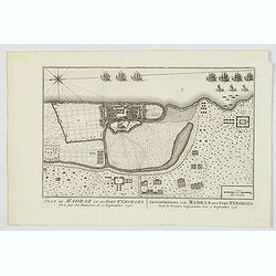
Plan de Madraz et du Fort St. Georges. Pris par les Francois le 21 Septembre 1746 / Grondtekening van Madras en't Fort St. Georges, door de Fransen ingenoomen den 21 September 1746.
A plan of the city of Chennai (then Madras) the capital of Tamil Nadu, in southern India, and the old British Fort of St George (captured during the brief French occupati...
Date: Amsterdam, ca 1756
Selling price: ????
Please login to see price!
Sold in 2021

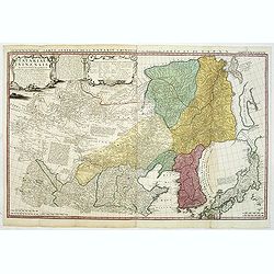
Carte de la province de Quan-tong, ou Lyau-tong et du Royaume de Kau-li. . .
Map of Korea. The map is of interest for the use of East Sea, the sea between Korea and Japan, here called "Mer de Corée" and "Meer von Korea".From a...
Date: Paris, 1757
Selling price: ????
Please login to see price!
Sold in 2023