Browse Listings in America > South America > Peru
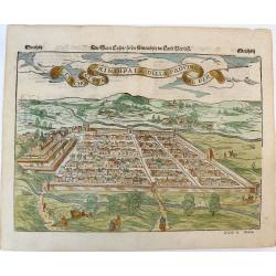
Der Statt Cusco / so die fuernembste im Land Peru / Il Cuscho Citta Principale della Provincia del Peru.
An early woodcut view of Cusco (Cuzco) in Peru by Sebastian Munster on a full double sheet. One of the earliest views of a city in the 'New World'. Verso an early woodcut...
Place & Date: Basel, H.Petri, ca. 1550
Selling price: $145
Sold in 2019
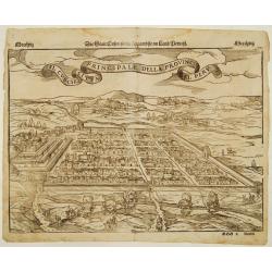
Il Cuscho citta principale della provincia del Peru.
A very desirable item of this decorative and early bid's-eye view of the Inca city of Cuzco, based on Antoine du Pinet's depiction of the city. Several figures shown insi...
Place & Date: Basle 1555
Selling price: $130
Sold
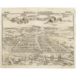
Il Cuscho citta principale della provincia del Peru.
A very desirable item of this decorative and early bid's-eye view of the Inca city of Cuzco, based on Braun & Hogenberg's depiction of the city. Several figures shown...
Place & Date: Basle, 1555
Selling price: $160
Sold
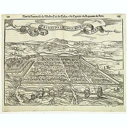
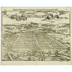
Il Cuscho citta principale della provincia del Peru.
A very desirable and scarce item of this decorative and early bid's-eye town-plan of the Inca city of Cuzco. Several figures shown inside the city walls and on the hillsi...
Place & Date: Lyons, 1564
Selling price: $450
Sold in 2012
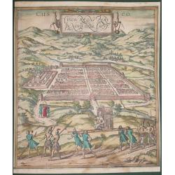
Cusco, Regni Peru in Novo Orbe Caput.
According to George Braun : "The capital of Peru in the south of the New world is Cusco, a city so large, powerful and beautiful that it can easily rank alongside th...
Place & Date: Antwerp, 1572
Selling price: $425
Sold in 2014
Principale della provincia citta del peru il cuscho.
On recto an early birds-eye view of Cusco. On verso tittle page and a plan of Mexico City "Urbs themistiana hispaniae" (165x162mm.)From a German text edition of...
Place & Date: Basle, 1550-1590
Selling price: $90
Sold in 2014
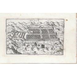
Cusco
Miniature town view of the City of Cuzco, Peru, with figures in the foreground Valegio signature at the lower edge of the plate. It was published as part of a series of b...
Place & Date: Venice, 1595
Selling price: $180
Sold in 2016
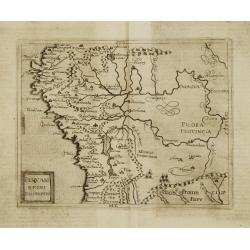
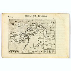
Peruani Regni Discriptio.
Very rare sixteenth century map of Peru.Published in the German edition of José de Acosta's De Natura Nova Orbis, first published in Salamanca, 1588. Acosta was a Spanis...
Place & Date: Cologne 1598
Selling price: $375
Sold
Peru.
An attractive miniature map of Peru, with north orientated to the right, published by Petrus Bertius in Amsterdam at the turn of the seventeenth century. Some interior i...
Place & Date: Amsterdam, 1606
Selling price: $80
Sold in 2023
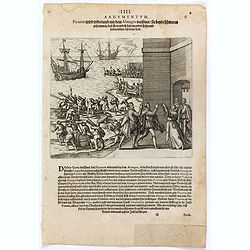
Pizzarus wird widerumb mit dem Almagro versönet sie beyde schweren zusammen dass sie trewlich bey einander stehn und halten wöllen biss in den Todt.
Francisco Pizarro and Pedro de Almagro swear an oath on the Host held by the priest, Hernando de Luque. The men stand in front of fortifications while ships are loaded by...
Place & Date: Frankfurt, 1607
Selling price: $150
Sold in 2016
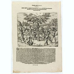
In der Insel Ferri genandt so eine auss den Canarien ist findet man kein ander süss wasser als nur so auss einem eintzigen Baum daselbst täglich herunder trieffet.
Natives of the Canary islands collect water falling from the leaves of a tree. Includes dwellings, vessels, and clouds over the tree. Text page with copper engraving page...
Place & Date: Frankfurt, 1607
Selling price: $150
Sold in 2020
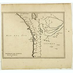
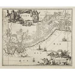
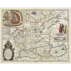
Descripcion Del Audiencia De los Charcas (Chile, Bolivia, Peru)
The earliest map to include information from the previously secret manuscript maps of the Spanish cosmographer, Juan López de Velasco, showing the Audiencia of the New K...
Place & Date: Amsterdam, Michel Colin, 1622
Selling price: $300
Sold in 2017
Peru.
Rare first state. Decorated with ships and monsters on the sea. Orientated with east at the top. A most decorative item. One of the most dramatic events in the early hist...
Place & Date: Amsterdam 1629
Selling price: $600
Sold
![Guame. [Spilbergen's fleet reaches Huarmey] / Payta [Spilbergen's fleet reach Paita].](/uploads/cache/41088-250x250.jpg)
Guame. [Spilbergen's fleet reaches Huarmey] / Payta [Spilbergen's fleet reach Paita].
Two engravings. [500] The town of Huarmey was situated about 150 miles north of Lima. It was conveniently located for ships because there was a natural harbour nearby wit...
Place & Date: Frankfurt, M.Merian, 1633
Selling price: $60
Sold in 2021
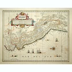
Peru.
FIRST EDITION, FIRST ISSUE OF THIS MAP. Decorated with ships and monsters in the sea. Orientated with east at the top. With the signature of G. Blaeuw lower right corner....
Place & Date: Amsterdam, 1634
Selling price: $450
Sold
Peru.
Decorated with ships and monsters on the sea. Orientated with east at the top. A most attractive item.
Place & Date: Amsterdam 1635
Selling price: $320
Sold
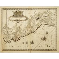
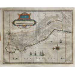
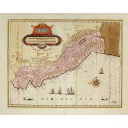
PERU.
Decorative map of Peru, shows the Pacific coast of South America from Ecuador (at the left-hand side) as far south as the Atacama desert in the northern reaches of Chile....
Place & Date: Amsterdam 1635
Selling price: $190
Sold
Peru.
French text edition. A map of Peru, orientated with north to the left, also showing most of Equador and Northern Chile, also includes Potosi, the famous mountain of silve...
Place & Date: Amsterdam, 1645
Selling price: $180
Sold in 2018
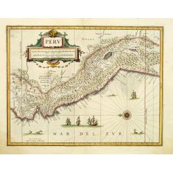
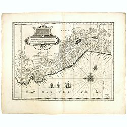
Peru.
Decorative map of Peru, featuring large decorative cartouche, compass rose, four sailing ships and three sea monsters. East to the top. Nearly 100 place names shown.
Place & Date: Amsterdam, c. 1645
Selling price: $195
Sold in 2012
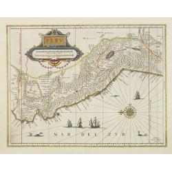
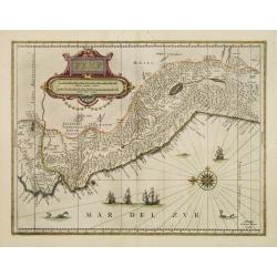
Peru.
Decorated with ships and monsters in the sea. Orientated with east at the top. With the signature of G. Blaeuw lower right corner. Shows the Pacific coast of South Americ...
Place & Date: Amsterdam, 1650
Selling price: $600
Sold in 2013
Peru.
Johan Blaeu succeeded his father Willem when the latter died in 1638. Johan led the Blaeu firm to its greatest achievement the ' Atlas Maior' in 12 parts, the greatest an...
Place & Date: Amsterdam, c. 1650
Selling price: $200
Sold in 2020
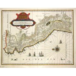
Peru.
First edition of the last part of the Latin "Atlas maior" dedicated to America.Decorated with ships and monsters on the sea. Orientated with east at the top. A ...
Place & Date: Amsterdam, 1662
Selling price: $510
Sold in 2009
Peru.
Map of Peru from De Nieuwe en onbekende Weereld.. published by Arnold Montanus, which was used by John Ogilby as the basis of his Complete History of America.The map exte...
Place & Date: Amsterdam, 1671
Selling price: $265
Sold
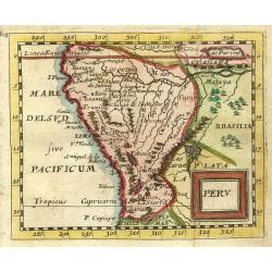
Peru.
"Nice miniature map covering the region from the Equator to the Tropic of Capricorn. At upper right corner in Brazil 'Lac Parime"" with the golden city 'Ma...
Place & Date: Paris 1679
Selling price: $120
Sold
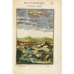
Cusco.
Charming view of the Peruvian town of Cuzco. From the French text edition of Description d'Univers, 1683. by Allain Manneson Mallet (1630-1706), a well travelled military...
Place & Date: Paris 1683
Selling price: $40
Sold
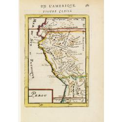
Perou.
Interesting map of Peru with the capital, Lima, in the centre.From the French text edition of Description d'Univers, 1683. by Allain Manneson Mallet (1630-1706), a well t...
Place & Date: Paris 1683
Selling price: $40
Sold
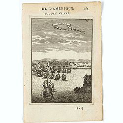
Callao.
Bird's-eye view of the fortified sea town of Callao, besieged by fighting ships.From the French text edition of Description d'Univers, 1683. by Allain Manneson Mallet (16...
Place & Date: Paris 1683
Selling price: $40
Sold
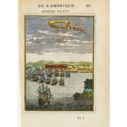
Callao.
A charming print of the fortified town and port of El Callao in Peru. Spanish and Dutch ships in the bay, engaged in battle.El Callao was founded by Spanish colonists in ...
Place & Date: Paris, 1683
Selling price: $30
Sold in 2022
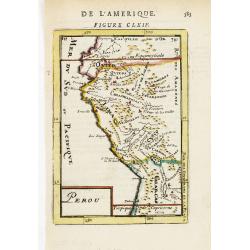
Perou.
Interesting map of Peru with the capital, Lima, in the centre.From the French text edition of Description d'Univers, 1683. by Allain Manneson Mallet (1630-1706), a well t...
Place & Date: Paris, 1683
Selling price: $25
Sold
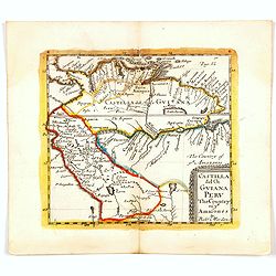
Castilla del Or Guiana Peru The Country of the Amazones.
A delightful small map of Peru and northern most portion of South America, into what is now north western Brazil. Showing and naming many of the large number of rivers th...
Place & Date: London, 1688
Selling price: $45
Sold in 2020
Peru ou Perou.
Charming map of Peru. Including some of the territory of today Equador on the north and extending southwards as far as the Atacama desert in Chile. Decorated with a large...
Place & Date: Amsterdam 1700
Selling price: $120
Sold
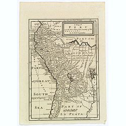
A Map of Peru and the West Part of the Country of the Amazones.
A map showing a good proportion of the west coast of South America, covering Peru, Chile, Western Brazil and Quito (Equador). Many coastal settlements and towns are engra...
Place & Date: London, 1711
Selling price: $60
Sold in 2019
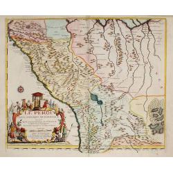
LE PEROU Dans l'Amérique Méridionale ?
Map of Peru including parts of present-day Ecuador, Bolivia, and Brazil. Cartographic elements include location of native American settlements, rivers, lakes, and wetland...
Place & Date: Paris, 1719
Selling price: $475
Sold in 2009
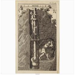
Mine.
Interesting print illustrating the entrance of a mine and part of a tunnel. It was mend to describe the hard labour to which the native Peruvian were forced.From "Vo...
Place & Date: Amsterdam, 1722
Selling price: $23
Sold in 2020
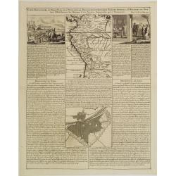
Carte Particuliere du Perou, Plan de la Ville de Lima, Description de Quelques Plantes, Animaux, &..
An interesting folio sheet containing two maps and two engravings with panels of French text. The top map covers the Northwest coast of South America from Panama to north...
Place & Date: Amsterdam 1728
Selling price: $100
Sold
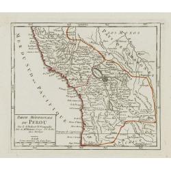
Partie Méridionale du Perou.
Detailed small map encompassing southern Peru, Bolivia and part of Chile. Centered on the lake Titicaca. Including the Atacama desert.From Atlas Portatif Universel, by Ro...
Place & Date: Paris, later than 1748
Selling price: $50
Sold in 2017
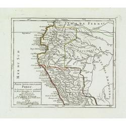
Partie Septentrionale du Perou. . .
Detailed small map encompassing the Ecuadorian seacoasts and the Peruvian shores as far as Lima.In the hinterland the first stretch of the River Amazon. From Atlas Portat...
Place & Date: Paris, later than 1748
Selling price: $60
Sold in 2018
![[9 maps of Peru and Chili]](/uploads/cache/20641-(1)-250x250.jpg)
[9 maps of Peru and Chili]
A map of the Southamerican continent from the Dutch edition of Robertson's ' History of America'.Plus 8 maps of Peru and Chili
Place & Date: London, ca. 1750
Selling price: $200
Sold in 2022
![Carte de la Meridiene mesurée au ROYAUME DE QUITO. . . [Karte von der Gemessenen Mittagslinie in dem Koenigreiche Quito. . .]](/uploads/cache/26172-250x250.jpg)
Carte de la Meridiene mesurée au ROYAUME DE QUITO. . . [Karte von der Gemessenen Mittagslinie in dem Koenigreiche Quito. . .]
A detailed map of Quito region, prepared in 1744. In: Allgemeine Historie der Reisen zur Wasser und zu Lande: oder Sammlung aller Reisebeschreibungen.. in Englischen zusa...
Place & Date: Leipzig, 1753
Selling price: $110
Sold in 2009
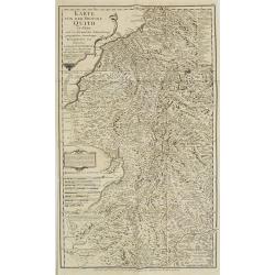
KARTE von der Provinz Quito in Peru. . . N°8.
Detailed map of Peru. In: Allgemeine Historie der Reisen zur Wasser und zu Lande: oder Sammlung aller Reisebeschreibungen.. in Englischen zusammen getragen, und aus demse...
Place & Date: Leipzig, 1753
Selling price: $110
Sold in 2009