Browse Listings in America > North America > North Pole
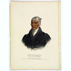
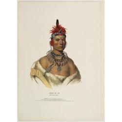
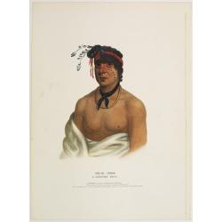
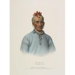
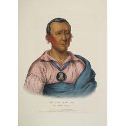
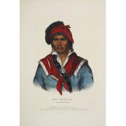
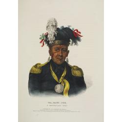
Ca-Ta-He-Cas-Sa-Black Hoof. Principal Chief of the Shawanoes.
Half-length portrait of Catahecassa wearing a dark colored jacked, grey vest, white shirt, and grey head scarf.A wonderful hand colored lithograph of Ca-Ta-He-Cas-Sa-Blac...
Place & Date: Philadelphia, 1837
Selling price: $175
Sold in 2017
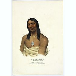
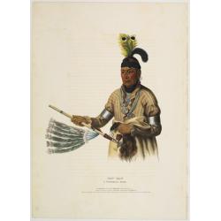
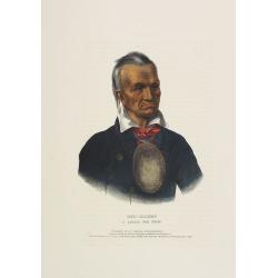
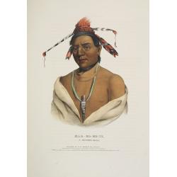
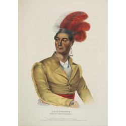
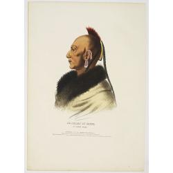
A-Na-Cam-E-Gish-Ca. A Chippeway Chief.
Half-length portrait of Anacamegishca, bare-chested, wearing a blanket and a peace medal. A-Na-Cam-E-Gish-Ca (1785-1862) - was a Chippeway Indian Chief. The Chippewa is o...
Place & Date: Philadelphia, 1837
Selling price: $185
Sold in 2017
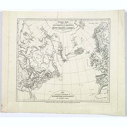
General Chart exhibiting the Discoveries of the Northmen in the Arctic Regions and America. . .
An interesting Danish map of many northern discoveries from the 10th to the 14th centuries, published by the Royal Society of Northern Antiquaries in Denmark. Map is base...
Place & Date: Copenhagen, 1837
Selling price: $35
Sold in 2017
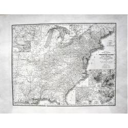
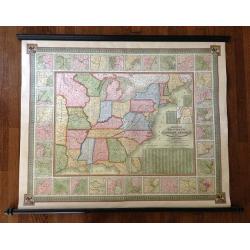
Young's Reise=Charte durch die Vereinigten Staaten von Nord America. Enthaltend alle Strassen, Dampfboot und Canal = Stationen, Staedte, Dorfer und Ansiedlungen. . .
A large, very detailed early German edition of J.H. Young's map of the United States. The translation of the German title reads: "Young's travel = Map of the United ...
Place & Date: Nurenberg, 1837
Selling price: $136
Sold in 2022
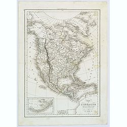
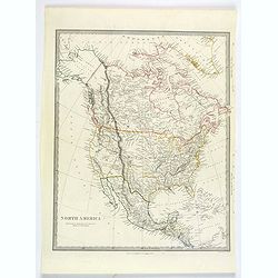
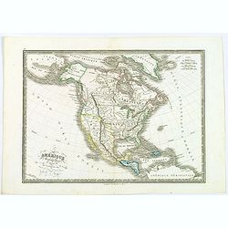
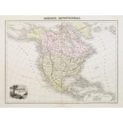
Carte de l'Amérique Septentrionale ..
Prepared by Alexandre Emile Lapie, a Colonel de l'Etat Major and first geographer to the King. Published by P.C.Lehuby, Rue de Seine 48, Paris. Engraved by Tardieu. Givin...
Place & Date: Paris 1838
Selling price: $80
Sold
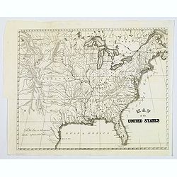
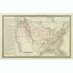
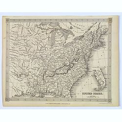
Map of the United States.
General map of the United States, dated around 1838 and shows Texas. Some place names, but mostly rivers and tributaries, lakes, territories mountains and some Indian tri...
Place & Date: America, 1838
Selling price: $40
Sold in 2017
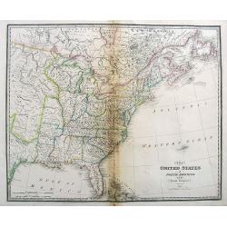
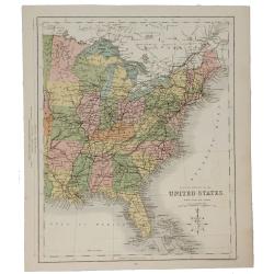
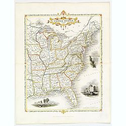
The United States of North America, with the British Territories.
A highly detailed map of the United States, extending from Missouri and Texas to New Found Land and the Bahamas.With some early names of regions, and several interesting ...
Place & Date: London, 1838
Selling price: $130
Sold in 2017
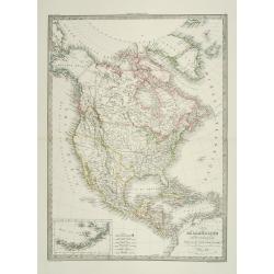
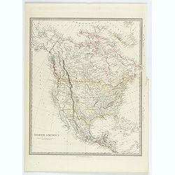
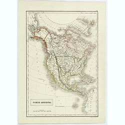
Carte de l'Amerique Septentrionale.
French map of North America showing Oregon Territory extending north into British Columbia in Canada, Missouri Territory extends from the shores of Lake Michigan across t...
Place & Date: Paris, 1838
Selling price: $43
Sold in 2017
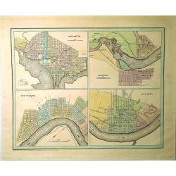
Washington, Louisville & Jefferson, New Orleans & Cincinnati.
Four city maps in full color. The map of Washington includes numbered locations including the Capitol, the State Department, Departments of War, Navy, and the Treasury, a...
Place & Date: New York, 1838
Selling price: $85
Sold in 2019
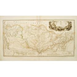
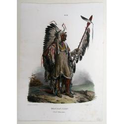
Carte itinéraire du Prince Maximilien..
Engraved map of the interior of the Northern U.S., from Atlantic seaboard to the Rocky Mountains with outline coloring indicating the route of travels and Indian nations....
Place & Date: Paris, Coblenz, or London, 1839
Selling price: $3525
Sold
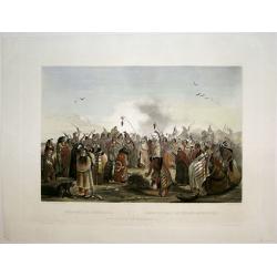
Scalp Dance of the Minatarris/ Scalptanz der Moennitarris/ Danse du Scalp des Indiens Meunitarris.
Print from: 'Reise in das innere Nord-America in den Jahren 1832 - 1834' by Prince Maximilian of Wied-Neuwied, after paintings by Karl Bodmer, engraved by Ch. Vogel, prin...
Place & Date: London, 1839
Selling price: $800
Sold in 2015
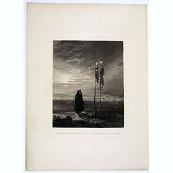
Offrande des Indiens Mandans.
This bleak, evocative and deeply spiritual engraving by Bodmer shows a Mandan skull shrine in 1833, located near the burial ground of Mih-Tutta-Hang-Kusch.Titles in Germa...
Place & Date: Pars, Coblenz, London, 1839
Selling price: $325
Sold
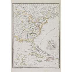
États Unis et Grandes Antilles.
America's east coast, the Great Lakes, Florida and the Caribbean.
Place & Date: Paris, 1840
Selling price: $150
Sold in 2017
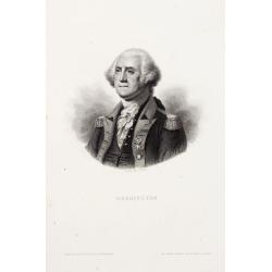
Washington.
Steel engraved portrait of Georges Washington, engraved by Ballin. Published by Dufour, Mulat et Boulanger Imp. Gilquin et Dupain, r. de la Calandre, 19, Paris.
Place & Date: Paris ca 1840
Selling price: $50
Sold
Stati-Uniti Dell'America settentrionale . . .
A rare and detailed double-page map of eastern part of the United States of America, including Great Lakes, Florida, engraved by G.V.Pasquali. According to the title cart...
Place & Date: Venice, 1840
Selling price: $350
Sold in 2016

America Settentrionale disegnata dopi i viaggi di Lewis, Clarke, Parry e Franklin. . .
A rare and detailed double-page map of eastern part of the United States of America, including Great Lakes, Florida, engraved by G.V.Pasquali.According to the title carto...
Place & Date: Venice, 1840
Selling price: $200
Sold in 2018
Amerique du nord.
The map depicts the short lived "Republic of Fredonia," a reference to the Fredonia Rebellion, the first attempt to create a separate independent Republic in Te...
Place & Date: Paris, Jules Renouard, ca.1840
Selling price: $120
Sold in 2012
Etats-Unis.
Finely engraved map prepared by A.H.Dufour and engraved by Giraldon-Bovinet, shortly before Texas became part of the United States. After gaining independence from Spain ...
Place & Date: Paris, Jules Renouard, ca.1840
Selling price: $80
Sold in 2012
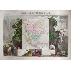
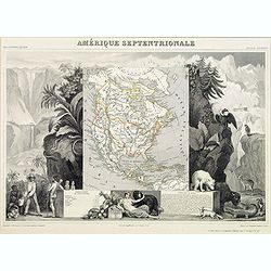
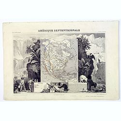
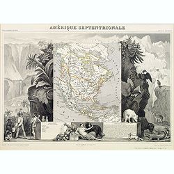
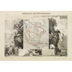
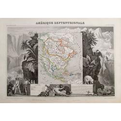
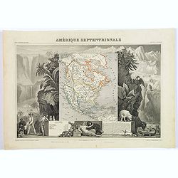
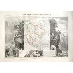
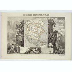
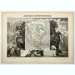
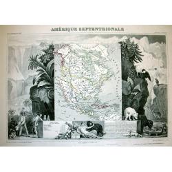
Amérique Septentrionale.
Very attractive map of America. To the left we find traders negotiating home-made products and a Maya pyramid. To the right we find plants and animals that are common for...
Place & Date: Paris, 1840
Selling price: $140
Sold in 2014
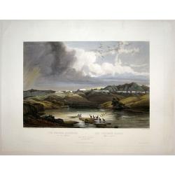
The White Castles on the Upper Missouri/ Die Weissen Schloesser am oberen Missouri/ Les Chateaux Blancs Missouri superior.
Aquatint from: 'Reise in das innere Nord-America in den Jahren 1832 - 1834' by Prince Maximilian of Wied-Neuwied, after paintings by Karl Bodmer, engraved by Himely, prin...
Place & Date: London, 1840
Selling price: $1200
Sold in 2015
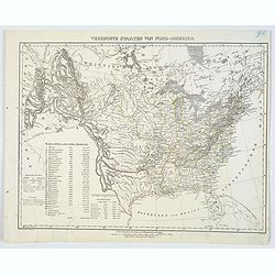
Vereinigte Staaten von Nord-America.
This handsome German map highlights the United States and her Territories, as numbered and outlined in yellow. The Republic of Texas (an independent nation until joining ...
Place & Date: Glogau, ca 1840
Selling price: $135
Sold in 2020
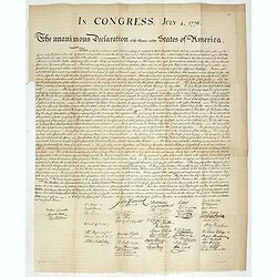
In congress, July 4, 1776. The unanimous declaration of the thirteen united Styates of America.
Scarce French reproduction based on William J. Stone’s official copperplate facsimile done by order of Congress. This French edition of the Declaration of Independance ...
Place & Date: Paris, Kaeppelin & Cie, 1840
Selling price: $4000
Sold in 2019
Eastern Division of the United States.
A fine chromolithograph map of the Eastern United States and parts of Canada. The Sioux, Fox, Chippewa and Algonquin Indian tribes are all mentioned. The capital of Arkan...
Place & Date: London, 1840
Selling price: $31
Sold in 2021
United States.
This detailed map of the United States that extends to show the eastern part of the Republic of Texas and a vast, and as yet unnamed western territory to the northwest of...
Place & Date: London, 1841
Selling price: $18
Sold in 2019
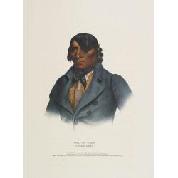
Chono Ca Pe an Ottoe chief.
A beautifully defined lithograph of Ottoe Indian Chief Chono Ca Pe from McKenney & Hall?s History of the Indian Tribes, perhaps the most important work ever published...
Place & Date: Philadelphia, circa 1836-1842
Selling price: $850
Sold
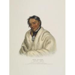
Wesh-Cubb a Chippway chief.
A beautifully defined lithograph of Chippway chief Wesh-Cubb from McKenney & Hall?s History of the Indian Tribes, perhaps the most important work ever published on No...
Place & Date: Philadelphia, circa 1836-1842
Selling price: $600
Sold
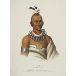
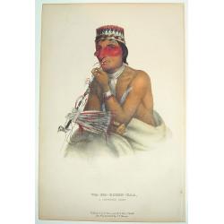
Naw-Kaw a Winnebago chief.
A beautifully defined lithograph of Winnebago chief Naw-Kaw, wearing a striped shirt, three peace medals around his neck, holding a peace pipe in one hand, what looks lik...
Place & Date: Philadelphia, circa 1836-1842
Selling price: $800
Sold
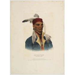
Shin-Ga-Ba-W'Ossin a Chippeway chief.
A beautifully defined lithograph of Chippeway chief Shin-Ga-Ba-W'Ossin from McKenney & Hall?s History of the Indian Tribes, perhaps the most important work ever publi...
Place & Date: Philadelphia, circa 1836-1842
Selling price: $800
Sold
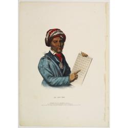
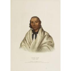
Se-Quo-Yah.
A beautifully defined lithograph of Se-Quo-Yah, or George Guess, the son of a white man and an Indian woman of mixed blood, recognized to this day for his creation of an ...
Place & Date: Philadelphia, circa 1836-1842
Selling price: $1050
Sold

Qua-Ta-Wa-Pea a Shawanoe chief.
A beautifully defined lithograph of Shawanoe chief who is wearing a Jefferson peace medal. From McKenney & Hall?s History of the Indian Tribes, perhaps the most impor...
Place & Date: Philadelphia, circa 1836-1842
Selling price: $1050
Sold
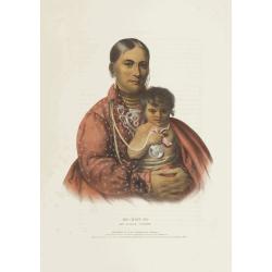
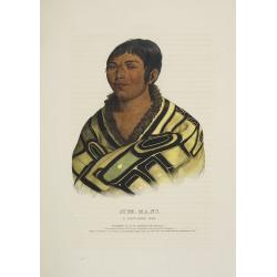
Mo-Hon-Go an Osage woman.
This hand-colored lithograph of Mo-Hon-Go, one of only eight women whose portraits appeared in this book. By contrast there were 111 men's portraits in it. Mo-hon-go, fl....
Place & Date: Philadelphia, circa 1836-1842
Selling price: $800
Sold in 2008
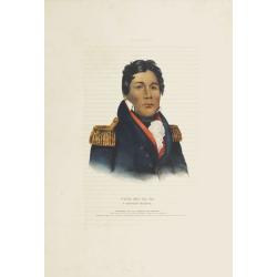
Little-Crow a Sioux Chief.
This hand-colored lithograph of Little-Crow a Sioux Chief. Chief Little Crow was the eldest son of Cetanwakuwa (Charging Hawk). It was on account of his father's name, mi...
Place & Date: Philadelphia, circa 1836-1842
Selling price: $950
Sold
Payta-Kootha a Shawanoe Warrior.
This hand-colored lithograph of Flying Clouds (Payta-kootha) (Shawnee) was probably painted by King in Washington, D.C., but the date is unknown. He was an itinerant, sel...
Place & Date: Philadelphia, circa 1836-1842
Selling price: $850
Sold
Push-Ma-Ta-Ha a Choctaw warrior.
This hand-colored lithograph of Pushmataha (ca. 1764-5 - 1824) (Choctaw), was a warrior noted for his vengeance on other Native Americans, notably Creeks and Seminoles, a...
Place & Date: Philadelphia, circa 1836-1842
Selling price: $725
Sold in 2008
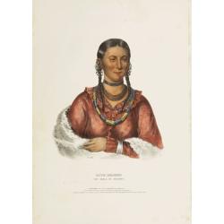
Hayne-Hudjihini the eagle of delight.
This hand-colored lithograph of Hayne-Hudjihini the eagle of delight, one of only eight women whose portraits appeared in this book. By contrast there were 111 men's port...
Place & Date: Philadelphia, circa 1836-1842
Selling price: $700
Sold in 2008
Tens-Kwau-Ta-Waw - The prophet.
A beautifully defined lithograph of a half-length portrait of Tenskwautawaw with right eye closed, wearing earrings, silver armband and necklace, red sash across his ches...
Place & Date: Philadelphia, circa 1836-1842
Selling price: $450
Sold in 2019
Tens-Kwau-Ta-Waw - The prophet.
A beautifully defined lithograph of a half-length portrait of Tenskwautawaw with right eye closed, wearing earrings, silver armband and necklace, red sash across his ches...
Place & Date: Philadelphia, circa 1836-1842
Selling price: $600
Sold in 2008
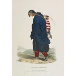
Chippeway Squaw & Child.
A beautifully defined lithograph of a Chippeway squaw and child, facing left. The woman is walking with head down, arms in blue blanket around her shoulders, child in car...
Place & Date: Philadelphia, circa 1836-1842
Selling price: $600
Sold in 2008
Kish-Kal-Wa. A Shawanoe chief.
A beautifully defined lithograph of a half-length portrait of Portrait of Kish Kal Wa, Shawanoe Chief. From McKenney & Hall's History of the Indian Tribes, perhaps th...
Place & Date: Philadelphia, circa 1836-1842
Selling price: $500
Sold in 2008
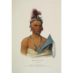
Red-Jacket A Seneca War chief.
A beautifully defined lithograph of a half-length portrait of the famous Seneca Indian Chief Red Jacket wearing his large-size, silver, oval 1792 Washington Peace Medal, ...
Place & Date: Philadelphia, circa 1836-1842
Selling price: $550
Sold in 2008
Waa-Pa-Shaw. A Sioux Chief.
A beautifully defined lithograph of a half-length portrait of Waa-Pa-Shaw, better known as Wabasha, he was chief of a Kiowa tribe of the Mdewakanton Sioux. He was treated...
Place & Date: Philadelphia, circa 1836-1842
Selling price: $450
Sold in 2008
Meta-Koosega. A chippeway warrior.
A beautifully defined lithograph of a half-length portrait of Meta-Koosega wearing an Indian Peace Medal, a blanket and black cravat. Disbound from McKenney and Hall's Hi...
Place & Date: Philadelphia, circa 1836-1842
Selling price: $450
Sold in 2008
Wat-Che-Mon-Ne, an Ioway Chief.
A beautifully defined lithograph of Wat-Che-Mon-Ne, an Ioway Chief from McKenney & Hall's History of the Indian Tribes, perhaps the most important work ever published...
Place & Date: Philadelphia, circa 1836-1842
Selling price: $390
Sold in 2008
Mar-Ko-Me-Te, a Menomene brave.
A beautifully defined lithograph of Mar-Ko-Me-Te, a Menomene brave from McKenney & Hall's History of the Indian Tribes, perhaps the most important work ever published...
Place & Date: Philadelphia, circa 1836-1842
Selling price: $440
Sold in 2008
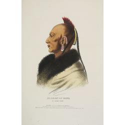
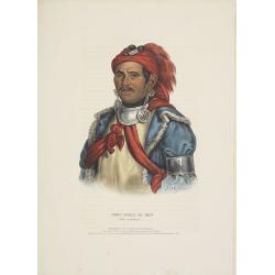
Le Soldat du Chene, an Osage Chief.
A beautifully defined lithograph of "Le Soldat du Chene, an Osage Chief " from McKenney & Hall’s History of the Indian Tribes, perhaps the most important ...
Place & Date: Philadelphia, circa 1836-1842
Selling price: $350
Sold in 2008
Stum-Ma-Nu, a Flat-Head boy.
A beautifully defined lithograph of Stum-Ma-Nu, a Flat-Head boy from McKenney & Hall's History of the Indian Tribes, perhaps the most important work ever published on...
Place & Date: Philadelphia, circa 1836-1842
Selling price: $390
Sold in 2008
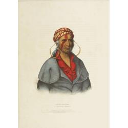
Nea-Math-La, a Seminole Chief.
A beautifully defined lithograph of Nea-Math-La, a Seminole Chief from McKenney & Hall's History of the Indian Tribes, perhaps the most important work ever published ...
Place & Date: Philadelphia, circa 1836-1842
Selling price: $460
Sold in 2008
Ahyouwaighs, Chief of the Six Nations.
A beautifully defined lithograph of Ahyouwaighs, Chief of the Six Nations from McKenney & Hall's History of the Indian Tribes, perhaps the most important work ever pu...
Place & Date: Philadelphia, circa 1836-1842
Selling price: $565
Sold in 2008
Tai-O-Mah, a Musquakee brave.
A beautifully defined lithograph of Tai-O-Mah, a Musquakee brave from McKenney & Hall's History of the Indian Tribes, perhaps the most important work ever published o...
Place & Date: Philadelphia, circa 1836-1842
Selling price: $630
Sold in 2008
Kee-Shes-Wa, a Fox Chief.
A beautifully defined lithograph of Kee-Shes-Wa, a Fox Chief from McKenney & Hall's History of the Indian Tribes, perhaps the most important work ever published on No...
Place & Date: Philadelphia, circa 1836-1842
Selling price: $490
Sold in 2008
Wa-Baun-See, a Pottawatomie Chief.
A beautifully defined lithograph of Wa-Baun-See, a Pottawatomie Chief from McKenney & Hall's History of the Indian Tribes, perhaps the most important work ever publis...
Place & Date: Philadelphia, circa 1836-1842
Selling price: $565
Sold in 2008
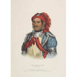
Le Soldat du Chene, an Osage Chief.
A beautifully defined lithograph of "Le Soldat du Chene, an Osage Chief " from McKenney & Hall’s History of the Indian Tribes, perhaps the most important ...
Place & Date: Philadelphia, circa 1836-1842
Selling price: $700
Sold in 2011
Mitchell's National Map of the American Republic or United States of North America Together with Maps of the Vicinities of Thirty -Two of the Principal Cities and Towns in the Union
Mitchell's National Map of the American Republic or United States of North America drawn by J.H. Young and engraved by J.H. Brightly. Map extends into the eastern part of...
Place & Date: 1843
Selling price: $1150
Sold in 2013
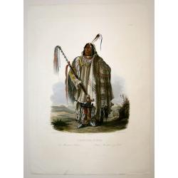
Pehriska-Ruhpa.
Aquatint from: 'Reise in das innere Nord-America in den Jahren 1832 - 1834' by Prince Maximilian of Wied-Neuwied, after paintings by Karl Bodmer, engraved by Paul Legrand...
Place & Date: Paris, 1837-1843
Selling price: $2200
Sold in 2015
North America.
A detailed map of North America, published by Charles Knight in London for the S.D.U.K. Country borders are in different outline colors, TX is seen as a republic. Map ext...
Place & Date: London ca 1843
Selling price: $65
Sold in 2019
North America.
A detailed map of North America, published by Charles Knight in London for the S.D.U.K. Country borders are in different outline colors, TX is seen as a republic. Map ext...
Place & Date: London ca 1843
Selling price: $95
Sold in 2019
North America.
This interesting transition map features Alaska as a part of Russia, California and Texas as a part of Mexico and Canada still "British Territories". Sidney H...
Place & Date: London, 1844
Selling price: $30
Sold in 2013
Mandan Chef. / Chef Mandan.
Original lithograph by J. Honegger, after an aquarell by Karl Bodmer, for Maximilian Prinz zu Wied's': "Reise in das innere Nord-America in den Jahren 1832 bis 1834&...
Place & Date: Zurich, 1845
Selling price: $450
Sold in 2015
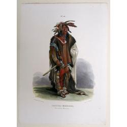
Dacota-Krieger./ Guerrier Dacota.
Original lithograph by J. Honegger, after an aquarell by Karl Bodmer, for Maximilian Prinz zu Wied's's: “Reise in das innere Nord-America in den Jahren 1832 bis 1834”...
Place & Date: Zurich, 1845
Selling price: $350
Sold in 2015
North America.
Sidney Hall's map of North America, showing Texas as a republic. Other interesting facts are that Alaska is still Russian Territory, Canada stretches down 'Western Territ...
Place & Date: London, ca 1845
Selling price: $75
Sold in 2020
Amérique septentrionale.
An uncommon map of North America prepared by N.Lorrain, who worked for Dépot de la Guerre. Showing the state of Texas as a republic. Mexico occupied the south west, and ...
Place & Date: Paris, 1845
Selling price: $70
Sold in 2020
![DIE VEREINIGTEN STAATEN VON NORD-AMERICA .. 1846 [Texas Republic]](/uploads/cache/85591-250x250.jpg)
DIE VEREINIGTEN STAATEN VON NORD-AMERICA .. 1846 [Texas Republic]
Rare late edition of Streit's fascinating map of the United States with inset maps of the region around Washington DC, Boston, Philadelphia, and New York. Very nice detai...
Place & Date: Leipzig, 1846
Selling price: $65
Sold in 2021
Amerique Septentrionale.
Beautiful map with the United States.
Place & Date: Paris, 1847
Selling price: $90
Sold in 2017
Amerique Septentrionale.
A beautiful map with the United States with Texas as a republic, and extending into present day Canada, Russia in control of Alaska, and Mexico's northern border defined ...
Place & Date: Paris, 1847
Selling price: $95
Sold in 2017
Amerique Septentrionale.
Beautiful map with the United States extending into present day Canada, Russia in control of Alaska and Mexico's northern border according to the Treaty of 1810. Surround...
Place & Date: Paris, 1847
Selling price: $120
Sold in 2019
North America.
Published by Chapman and Hall from "Sharpe's Corresponding Maps".
Place & Date: London, 1848
Selling price: $35
Sold in 2019
Amérique Septentrionale.
A very decorative map with the United States extending into present day Canada, Russia in control of Alaska and Mexico's northern border according to the Treaty of 1810. ...
Place & Date: Paris 1850
Selling price: $200
Sold
Amérique Septentrionale.
A nice map of the continent showing the national boundaries, but not the individual states and provinces.The United States is shown with its boundary with Canada complete...
Place & Date: Paris 1850
Selling price: $100
Sold
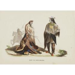
![Opperhoofd der Vos Indiaanen. [Fox indians]](/uploads/cache/23391-250x250.jpg)
Opperhoofd der Vos Indiaanen. [Fox indians]
Decorative, hand colored, woodcut engraving illustrating the chief of the Fox Indian tribe.After a war with the Illinois (c.1765), the Fox moved into Illinois territory. ...
Place & Date: Amsterdam, ca. 1850
Selling price: $20
Sold in 2016
Groep van Raven-Indiaanen.
Decorative, original hand colored, woodcut engraving illustrating a group of Native Americans belonging to the Raven tribe.
Place & Date: Amsterdam, ca. 1850
Selling price: $20
Sold in 2016
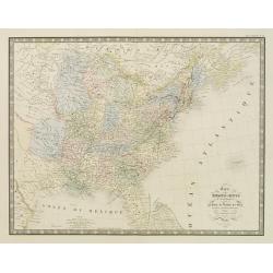
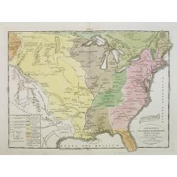
Carte des Etats-Unis d''''Amérique comprenant une Partie des Districts de l''''Ouest et de la Nouvelle Bretagne..
Map of the states east of the Mississippi and the adjacent Indian Territories to the west. Texas is shown as a separate state.Relief shown by hachures. From the Atlas cl...
Place & Date: Paris, 1850
Selling price: $150
Sold in 2020
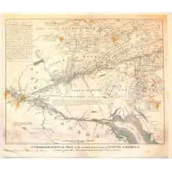
A Chorographical Map of the Northern department of North America.
A detailed map of the United States and Canada showing Lake Ontario and the St. Lawrence River at the bottom with New Hampshire at the top. This is a smaller edition of a...
Place & Date: New Haven, 1850
Selling price: $114
Sold in 2015
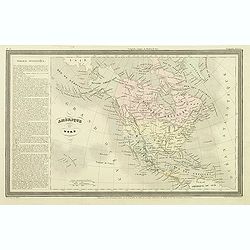
Amérique Septentrionale.
Important French map of North America, showing Texas as an independent republic. The population table lists Texas with 200.000 and the United States with 19.000.000 inha...
Place & Date: Paris, ca. 1850
Selling price: $100
Sold in 2018
Amerique Septentrionale.
A beautiful map of the United States with Texas as a Republic, and extending into present day Canada, Russia in control of Alaska, and Mexico's northern border defined ac...
Place & Date: Paris, ca 1850
Selling price: $95
Sold in 2018
United States, East..
A delightful small map of the eastern portion of the United States, by Alfred Adlard, published in his Vignette Modern School Atlas of the World. When looking at this map...
Place & Date: London, 1850
Selling price: $65
Sold in 2020
Amérique Septentrionale.
An important French map of North America, showing Texas within Mexico. The population table lists Texas with 200.000 and the United States with 19.000.000 inhabitants. Th...
Place & Date: Paris, ca 1850
Selling price: $62
Sold in 2018
Amerique Septentrionale.
A beautiful map of the United States with Texas as a Republic, and extending into present day Canada, Russia is in control of Alaska, and Mexico's northern border defined...
Place & Date: Paris, ca 1850
Selling price: $85
Sold in 2020
Amerique Septentrionale.
A beautiful map of the United States with Texas as a Republic, and extending into present day Canada, Greenland and the Arctic are shown, Russia is in control of Alaska, ...
Place & Date: Paris, ca 1850
Selling price: $100
Sold in 2020
Wa-Em-Boesh-Kaa, A Chippeway Chief
A beautifully defined lithograph of a Chippewa chief, from Mckeeney and Hall?s Indian Tribes of North America, perhaps the most important work ever published on North Ame...
Place & Date: Philadelphia, ca.1851
Selling price: $260
Sold
Amérique Septentrionale
Important French map of North America, showing Texas as an independent republic. The population table lists Texas with 200.000 and the United States with 19.000.000 inhab...
Place & Date: Paris 1851
Selling price: $200
Sold in 2008