Browse Listings in America > North America > North Pole
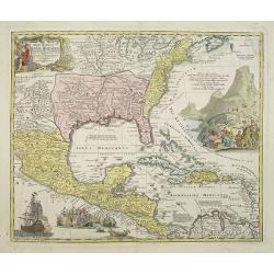
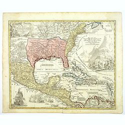
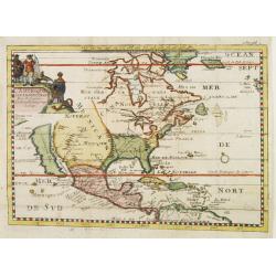
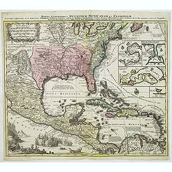
Regni Mexicani seu Novae Hispaniae, Floridae, Novae ..
The map shows the eastern sea board of America, the West Indies and the various estates and countries that border the Gulf of Mexico, with decorative cartouches. The map ...
Place & Date: Nuremberg 1720
Selling price: $1600
Sold in 2009
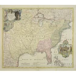
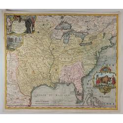
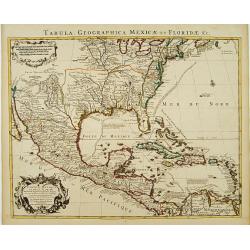
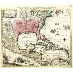
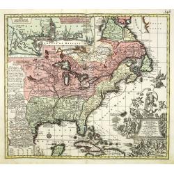
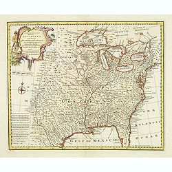
Amplissimae Regionis Mississipi,.. Provinciae Ludovicianae..
Attractive map of present-day U.S. from Nouveau Mexico to the Atlantic, centering on the French province of Louisiana, with the English colonies and Spanish Florida indic...
Place & Date: Nuremberg 1720
Selling price: $2530
Sold in 2009
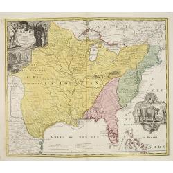
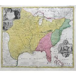
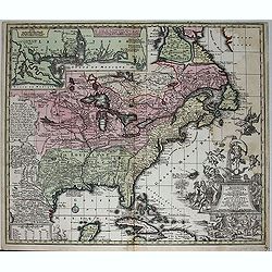
Amplissimae Regionis Mississipi,.. Provinciae Ludovicianae. . .
Attractive map of present-day U.S. from Nouveau Mexico to the Atlantic, centering on the French province of Louisiana, with the English colonies and Spanish Florida indic...
Place & Date: Nuremberg, 1720
Selling price: $2200
Sold in 2019
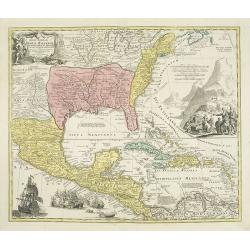
Regni Mexicani seu Novae Hispaniae, Floridae, Novae . . .
The map shows the eastern sea board of America, the West Indies and the various estates and countries that border the Gulf of Mexico, with decorative -uncolored- cartouch...
Place & Date: Nuremberg, 1720
Selling price: $1750
Sold in 2019
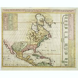
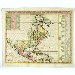
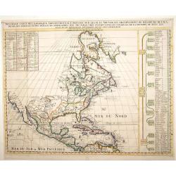
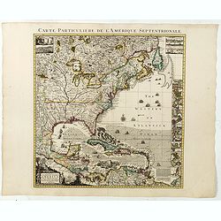
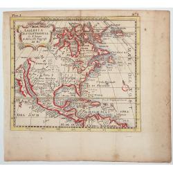
Nouvelle Carte de l\' Amerique Septentrionale Dressee sur les plus Nouvelles Observations de Messieurs de l\' Academie. . .
Great map of North America with well developed cartography in the Great Lakes and Mississippi River.It includes all of Central America and the West Indies. The English se...
Place & Date: Amsterdam, 1720
Selling price: $210
Sold in 2011
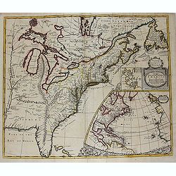
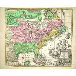
A new map of the English Empire in America. . .
This fine English map of eastern North America including Canada engraved by John Harris and first published by Robert Morden. John Senex acquired and made minor alteratio...
Place & Date: London, 1720
Selling price: $1400
Sold in 2013
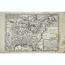
A new map of New France containing Canada, Louisiana &c. in N.th America. . .
A fine map of Canada, Great Lakes and most of South east New Foundland. For this edition the London meridian is used with Deg.West from London and Deg.East from London en...
Place & Date: London, c. 1720
Selling price: $255
Sold in 2013
Regni Mexicani seu Novae Hispaniae, Floridae, Novae ..
The map shows the eastern sea board of America, the West Indies and the various estates and countries that border the Gulf of Mexico, with decorative, uncolored cartouche...
Place & Date: Nuremberg, 1720
Selling price: $900
Sold in 2016
Regni Mexicani seu Novae Hispaniae, Floridae, Novae ..
The map shows the eastern sea board of America, the West Indies and the various estates and countries that border the Gulf of Mexico, with decorative -uncolored- cartouch...
Place & Date: Nuremberg, 1720
Selling price: $1050
Sold in 2016
Amplissimae Regionis Mississipi Seu Provinciae Ludovicianae. . .
An iconic copperplate Map of the Mississippi Valley (United States, Louisiana, Texas, British Colonies) by Johann Baptiste Homann in Nuremberg in 1720. This map is often ...
Place & Date: Nuremberg, 1720
Selling price: $850
Sold in 2017
Amplissimae Regionis Mississipi... (The Bufflao Map).
Homann's important and highly decorative map of the Mississippi River Valley and the Southeast USA. Extends from the Great Lakes until the Bahamas, including Louisiana an...
Place & Date: Nuremberg, c. 1720
Selling price: $850
Sold in 2017
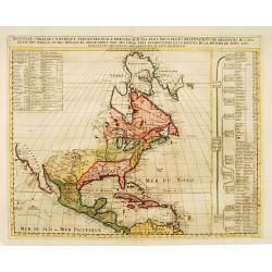
Nouvelle Carte de l' Amerique Septentrionale Dressee sur les plus Nouvelles Observations de Messieurs de l' Academie. . .
A superb map of North America with well developed cartography in the Great Lakes and Mississippi River.It takes in all of Central America and the West Indies. The English...
Place & Date: Amsterdam, 1720
Selling price: $630
Sold in 2020
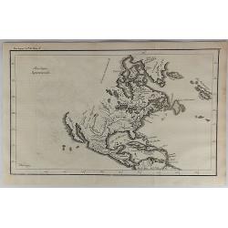
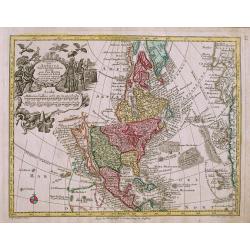
Amerique Septentrionale Par N.Sanson d\'Abbeville Geograph du Roy.
A general map of North America showing California as an island but with few names.From the book \"Nouvelle Relation, Contenant LES VOYAGES DE THOMAS GAGE dans la nou...
Place & Date: Amsterdam, 1721
Selling price: $326
Sold
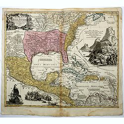
Carte du Mexique et de la Floride des Terres Angloises et des Isles Antilles. . .
Covens & Mortier's issue of Delisle's important map showing the south-eastern part of the United States, Mexico and the Caribbean Sea. It is credited with accurately ...
Place & Date: Amsterdam, c. 1722
Selling price: $900
Sold in 2016
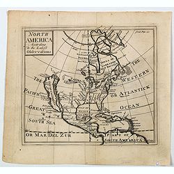
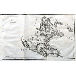
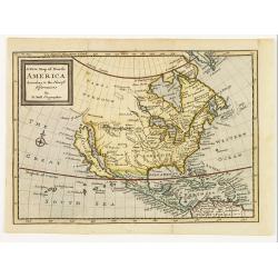
North America According to the Latest Observations.
State 1 with north latitude 60 deg. above the Arctic Circle. First issued in: Geography Anatomiz'd... The ninth edition. . . and a set of new maps by Mr. Senex / Patrick ...
Place & Date: London, ca 1722
Selling price: $130
Sold in 2023
L'Amérique Septentrionale suivant Mr. Delisle de l'Académie Royale des Sciences.
A copper engraving map of the North American continent from the atlas Science des personnes de la cour, a rare and richly illustrated handbook for aristocrats at the roya...
Place & Date: Amsterdam, 1723
Selling price: $50
Sold in 2018
Nouvelle Carte L'Amérique Septentrionale..
Map of Northern America, including northern Venezuela and Baffin Bay. All five of the Great Lakes are present: but Lake Erie is unnamed. The Ohio River is shown, but unna...
Place & Date: Amsterdam 1728
Selling price: $500
Sold
Nouvelle Carte L'Amérique Septentrionale..
Map of Northern America.
Place & Date: Amsterdam 1728
Selling price: $600
Sold
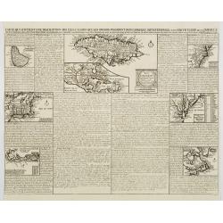
Carte qui contient..Iles & Terres..L'Amerique..Jamaique..
Eight maps on one sheet. From Chatelain's Atlas Historique et Méthodique. Including maps of Bermuda, Jamaica, New England with Long Island, Carolina, Chesapeake and Dela...
Place & Date: Amsterdam, 1728
Selling price: $420
Sold
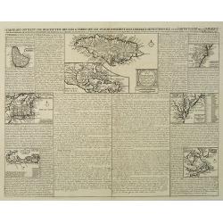
Carte qui contient une description des iles & terres que les anglois possedent dans L'Amerique Septentrionale . . . Jamaique. . .
Eight maps on one sheet showing the English colonies in North America including Barbados, Jamaica, New England, Bermuda, part of Canada showing the St. Lawrence River and...
Place & Date: Amsterdam, 1728
Selling price: $400
Sold in 2016

L'Amerique Septentrionale suivant les nouvelles observations ..
Splendid map of North America.These separately engraved border frames appear much more uncommon than the standard edition without border frames. From Galerie Agréable du...
Place & Date: Amsterdam 1729
Selling price: $850
Sold
Amerique Septentrionale.
An interesting map of North America, from “METHODE POUR ETUDIER L’HISTOIRE” by L’Abbe Lenglet du Fresnoy, published in Paris in 1729. The map is quite rare, and i...
Place & Date: Paris, 1729
Selling price: $425
Sold in 2017
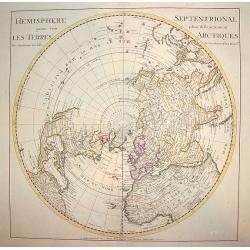
Hemisphere Septentrional pour voir plus.. les Terres..
The Covens & Mortier edition of this highly important map of the Northern Hemisphere. This work is the first to correctly place the west coast of North America by mov...
Place & Date: Amsterdam, ca. 1730
Selling price: $300
Sold
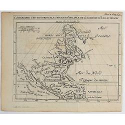
Accurata delineatio....Gallice Louisiane ol. Cauad' et Floridae
Full title: Accurata delineatio celeberrimae Regionis Ludovicianae vel Gallice Louisiane ol. Cauad' et Floridae adpellatione in Septemtrionali America. A beautiful map of...
Place & Date: Germany, 1730
Selling price: $2600
Sold
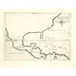
Descripcion de las Yndias des Norte. 2.
Rare map of the Americas, one of the very few Spanish printed maps of America, first published in the 1601 first edition of Herrera's Historia General, the present map ap...
Place & Date: Madrid, 1726, 1728, 1730
Selling price: $525
Sold in 2012
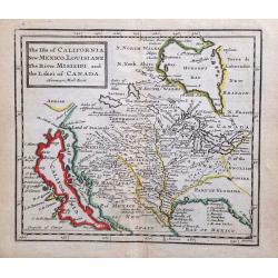
The Isle of California, New Mexico, Louisiane, The River Misisipi and the Lakes of Canada.
Printed in London, 1732. From Herman Moll's "A System of Geography." A scarce and remarkable map of California.California is as an island, with over a dozen pla...
Place & Date: London, 1732
Selling price: $400
Sold in 2014
Amerique Septentrionale
A scarce copper engraving of colonial North America. The map shows the area from Greenland until the northern part of South America. Extends until California, but with la...
Place & Date: Paris, 1734
Selling price: $80
Sold in 2021
Mappa Geographica Regionem Mexicanam et Floridam.
It covers Central America with the Caribbean and the eastern part of the United States to the Great Lakes and New Mexico. In the lower-left is a beautiful picture of a na...
Place & Date: Augsburg, 1735
Selling price: $1100
Sold in 2013
Accurata delineatio celeberrimae reg. Ludovicianae. . .
Includes the area from the Great Lakes to the Caribbean, in the center of the map the basin of the river Mississippi. In an inset part of Louisiana. With a very elaborate...
Place & Date: Augsburg, 1735
Selling price: $1900
Sold in 2010
Mappa Geographica Regionem Mexicanam et Floridam.
Covers Central America with the Caribbean and the eastern part of the United States to the Great Lakes and New Mexico. In lower left a beautiful picture of a naval battle...
Place & Date: Augsburg, 1735
Selling price: $850
Sold in 2012
Accurata delineatio celeberrimae reg. Ludovicianae. . .
Includes the area from the Great Lakes to the Caribbean, in the center of the map the basin of the river Mississippi. In an inset part of Louisiana. With a very elaborate...
Place & Date: Augsburg, 1735
Selling price: $2300
Sold
Accurata delineatio celeberrimae reg. Ludovicianae. . .
Includes the area from the Great Lakes to the Caribbean, in the center of the map the basin of the river Mississippi. In an inset part of Louisiana. With a very elaborate...
Place & Date: Augsburg, 1735
Selling price: $1300
Sold in 2012
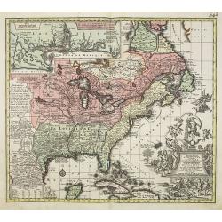
A Map of the British Empire in America with the French Spanish and Hollandish Possessions adjacent thereto by Henry Popple.
This is the one-sheet key map from the Dutch edition. 22 insets and views of various harbors and sights. This example is the rare FIRST state of the edition published by ...
Place & Date: Amsterdam, 1737
Selling price: $2000
Sold in 2020
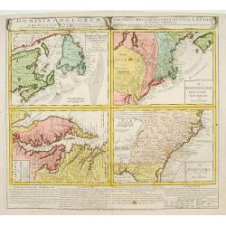
Dominia Anglorum in America Septentrionali/ Sie Gros-Brittanische Colonie Lænder in Nord-America. . .
Four maps on one sheet (Virginia und Maryland; Carolina nebsteinem Theil von Florida; New Engelland, New York, New Yersey und Pensilvania; and New Foundland, od. Terra No...
Place & Date: Nuremberg, 1740
Selling price: $600
Sold in 2015
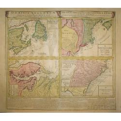
Dominia Anglorum in America Septentrionali.
Four maps on one sheet (New Foundland/ New England/ Virginia and Carolina/Florida) based on J.B.Homann\'s map, showing British possessions in North America. At bottom of ...
Place & Date: Nuremberg 1740
Selling price: $690
Sold in 2009
Nova Orbis Sive America Septentrionalis.
Oddly shaped, early 18th century German map of North America, with California as an island. Decorative cartouche with native Americans and birds.
Place & Date: Augsburg, c1740
Selling price: $450
Sold in 2014
AMERICA SETTENTRIONAL di N. Sanson (California Island)
Very rare old outline color example of Nicolas Sanson's map of North America. California is depicted as an island; McLaughlin notes: "California with indented northe...
Place & Date: NAPLES, ca 1740
Selling price: $190
Sold in 2020
![[7 sheets] A Map of the British Empire in America with the French Spanish and Dutch Possessions adjacent thereto by Henry Popple.](/uploads/cache/38145-250x250.jpg)
[7 sheets] A Map of the British Empire in America with the French Spanish and Dutch Possessions adjacent thereto by Henry Popple.
Seven map sheets, uncut, the first six with colored borders and outline coloring, each approximately 515 x 498 images (550 x 664 mm). Including the preliminary key map, f...
Place & Date: Amsterdam, 1742
Selling price: $10250
Sold in 2017
A new & accurate map of Louisiana, with part of Florida. . .
An English view of North America compiled from available French maps, especially those of Bellin used in Charlevoix's History of New Franc. English cartographers had litt...
Place & Date: London, 1744
Selling price: $800
Sold in 2020
A new map of North America according to the newest observations..
A very fine map of North America, including the West Indies and northern South America.With Straits of Anian and Mozeemlek to north and Gulf of California to east., the B...
Place & Date: London 1745
Selling price: $300
Sold