Browse Listings in America > North America > Great Lakes / Philadelphia
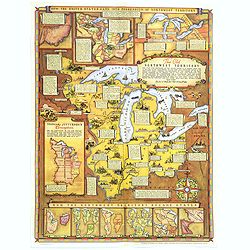
Historical Map of the Old Northwest Territory.
A large, folding lithographic map of the "Old Northwest Territory" in the time of Thomas Jefferson. This map seems to cover the states of Illinois, Indiana, Ohi...
Place & Date: Ohio, ca. 1940
Selling price: $255
Sold in 2016
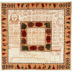
A Map of Downtown Chicago.
Silk map of Chicago’s Loop issued to celebrate the 100th anniversary of Marshall Field & Company.Though it nominally functions as a map of Chicago’s downtown, the...
Place & Date: United-states, 1952
Selling price: $200
Sold in 2021
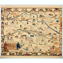
The Main Line. A Historical Map of Ye Outlying Regions . . .
A pictorial map depicting the geography, history and landmarks of the Main Line, the informal name for a group of western suburbs of Philadelphia, Pennsylvania. The area ...
Place & Date: Philadelphia, 1975
Selling price: $67
Sold in 2020
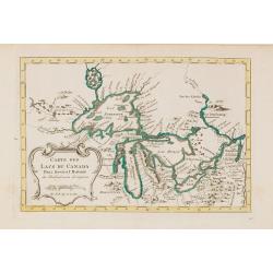
Carte des Lacs du Canada..
Scarce edition of this accurate map showing the all the Great Lakes in the traditional Bellin configuration.Kershaw does not mention this state with in lower right corner...
Place & Date: Amsterdam, 1773.
Selling price: $500
Sold in 2014